Weiβ, dass (expressing opinions) (translate weiβ as know & dass as that)
Dr. Kerstin Jochumsen Universität Hamburg Centrum für Erdsystemforschung und Nachhaltigkeit (CEN) Institut für Meereskunde Bundesstr. 53 D-20146 Hamburg Germany Phone +49 40 42838 7070 Fax +49 40 42838 7477
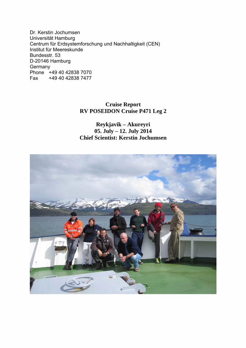
Cruise Report RV POSEIDON Cruise P471 Leg 2
Reykjavik – Akureyri
05. July – 12. July 2014 Chief Scientist: Kerstin Jochumsen
1. Objectives The purpose of the cruise was the collection of hydrographic and current data at high spatial resolution in the Denmark Strait region, as well as the exchange of moored instrumentation. The data will contribute to ongoing projects (BMBF RACE and EU NACLIM) on the variability of exchanges between the Atlantic and Arctic basins, and to the monitoring of the AMOC. The results will be combined with older data (e.g.P437-1, M82-1, MSM21-1b) to investigate the variability of the Denmark Strait Overflow Water (DSOW) plume. Goal 1: Observing the properties of DSOW in the Denmark Strait region The first objective of the cruise was to obtain high resolution hydrographic and current data from vessel operated systems (CTD/LADCP, vm-ADCP) covering the source region of the overflow and the DSOW distribution along the sill of the strait. Goal 2: Servicing the moorings in Denmark Strait The second purpose of the cruise was to recover the moorings and PIES monitoring the Denmark Strait overflow volume transport, which are used to maintain the time series of DSOW as established since 1996. One new, trawl-resistant mooring with an Acoustic Doppler Current Profiler (ADCP), one additional ‘standard’ ADCP mooring, and two current meter moorings were added to the ‘traditional’ array of two ADCP moorings. The additional instrumentation will improve the quality of the transport estimates of the overflow. Furthermore, the recovery of three current meter/ADCP and Microcat moorings was planned, which were measuring the fresh water transport in the East Greenland Current.
2. Cruise participants and crew
Scientific cruise participants
Kerstin Jochumsen IFM-CEN Chief scientist Detlef Quadfasel IFM-CEN Scientist, CTD and moorings Martin Moritz IFM-CEN Scientist, CTD and oxygen titration, PIES Christoph Rieper IFM-CEN Scientist, CTD and oxygen titration Andreas Welsch IFM-CEN Mooring technician Ulrich Drübbisch IFM-CEN Mooring technician Roald van der Heide NIOZ Mooring technician Lorendz Boom NIOZ Mooring technician
Institut für Meereskunde (IFM-CEN) Centrum für Erdsystemforschung und Nachhaltigkeit Universität Hamburg Bundesstr. 53 20146 Hamburg Germany http://www.ifm.uni-hamburg.de Royal Netherlands Institute for Sea Research (NIOZ) Landsdiep 4 1797 SZ 't Horntje (Texel) The Netherlands http://www.nioz.nl
Crew list Matthias Günther Master Theo Griese Chief Officer Sebastian Pengel 2nd Officer Kurre Klaas Kröger Chief Engineer Björn Brandt 2nd Engineer Joachim Mischker Bosun Bernd Rauh Ships Mechanics Sven Erber Ships Mechanics Marcel Deeke Ships Mechanics Niels Petersen Ships Mechanics Ronald Kuhn Able bodied Seaman Ralf Meiling Motorman Gerd Neitzel Electrician Klaus Peter Malchow Cook Sylvia Kluge Stewardess
3. Narrative RV Poseidon left the port of Reykjavik (Iceland) on July 5th at 11:45 UTC. The departure was delayed due to the bad weather conditions around Iceland; the ship observed still 20 m/s of wind speed and 8°C air temperature shortly after departure. The underway measurements were started at 13:10 UTC during the same day, at the position 64°13.9’N and 22°7.4’W. While the thermosalinograph measured without problems, the ADCP did not get any information from the ship’s heading and therefore had a malfunction. This problem could be solved during the evening. On Sunday evening (6th of July) RV Poseidon reached the first CTD station, which was located close to PIES DS1. The operating CTD was the instrument belonging to the University of Kiel, with two LADCPs from Hamburg attached to it. The CTD cast started at 19:32 UTC and ended 20:40 UTC. During the cast acoustic releases were tested and Microcats attached to the rosette frame were calibrated. When the rosette came back on deck, the upper LADCP made contact with the ship’s hull and was damaged visibly. The second CTD station was carried out only 5 nm away from the first, where another PIES was situated (PIES DS2). The weather had calmed and CTD work was no problem. Surprisingly the LADCPs were both working fine, despite the damage of beam 1. After the two CTDs PIES telemetry was started. The telemetry broke down three times during the night, but overall the readout was successful and finished at 7:45 UTC in the morning. At the end of the PIES telemetry the instrument was released at 8:04 UTC on Monday morning (7th of July). The recovery was completed at 9:11 UTC. Then the mooring DS2-13 was recovered, which was at a close by position (on deck at 9:44 UTC). The new mooring DS2-14 was deployed at 10:30 UTC. Only two miles away mooring DS20-14 was deployed (11:29 UTC). After a short transit (and lunch) a new bottom lander was deployed (DS21-14). The lander was in the water at 13:04 UTC, but had to be lowered slowly and was placed at the bottom at 14:31 UTC.
The lowering was done by a winch cable, which was connected to the lander with an acoustic release. When this release was back on deck, it was apparent that is was dredged along the sea floor, as there were stones in the transducer cage. Finally, a mooring with a Current Meter (RCM8) was brought into the water (DS22-14). It consisted only of one RCM and buoyancy and will be recovered in 2015 by dredging a bottom line. RV Poseidon then traveled back to the position of PIES DS1, where telemetry was started. When passing by the lander position, a release diagnostic was carried out. It showed that the release is in an upright position, as desired.
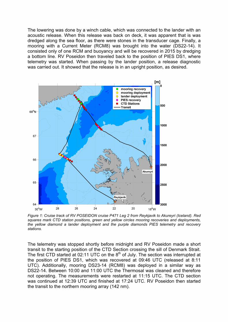
Figure 1: Cruise track of RV POSEIDON cruise P471 Leg 2 from Reykjavik to Akureyri (Iceland). Red squares mark CTD station positions, green and yellow circles mooring recoveries and deployments, the yellow diamond a lander deployment and the purple diamonds PIES telemetry and recovery stations. The telemetry was stopped shortly before midnight and RV Poseidon made a short transit to the starting position of the CTD Section crossing the sill of Denmark Strait. The first CTD started at 02:11 UTC on the 8th of July. The section was interrupted at the position of PIES DS1, which was recovered at 09:46 UTC (released at 8:11 UTC). Additionally, mooring DS23-14 (RCM8) was deployed in a similar way as DS22-14. Between 10:00 and 11:00 UTC the Thermosal was cleaned and therefore not operating. The measurements were restarted at 11:15 UTC. The CTD section was continued at 12:39 UTC and finished at 17:24 UTC. RV Poseidon then started the transit to the northern mooring array (142 nm).
On the 9th of July the position of mooring KGA12-3 (lander) was reached at 12:38 UTC. The release responded clearly so that a release command was send (at 12:41 UTC) although the sight was hindered by fog. The lander was successfully recovered at 12:57 UTC. The close by mooring KGA12-2 was recovered under the same conditions (on deck at 13:43 UTC). At the end of the recovery a machine shutdown occurred and RV Poseidon had to wait for a few hours until it was fixed. Before dinner the ship was fully operating again and resumed the working plan with the transit to the KOGUR CTD section (18 nm). The CTD section (stations 732-740) was completed at 7:00 UTC in the morning of the 10th of July. At 8:30 UTC the mooring KGA13-2 was reached and recovered (on deck at 9:04 UTC) under perfect weather conditions. At 12:44 UTC a calibration CTD was carried out for the recovered Microcats. In the afternoon several attempts were made to get in contact with mooring KGA11, which was deployed in 2012 and could not be recovered in 2013. Although several positions were tried, no contact with the release was possible. The mooring was supposedly dragged by an iceberg to a downstream position. The search for the mooring was abandoned at 17:00 UTC. RV Poseidon then started the transit to the position of a PIES located at the Icelandic shelf break (60 nm). PIES NIJ was reached at 1:35 UTC on 11th of July. Telemetry was carried out until the morning, when a calibration CTD was performed (6:30 UTC). At 7:36 UTC the PIES was released and at 8:16 UTC on deck. The following hours were spent with CTD work (Section NIJ, stations 745-750), until the weather was rough again. RV Poseidon then started the transit to Akureyri (170 nm). The station work was finished at 17:30 UTC on 11th of July. Underway measurements were taken until the 3 nm zone off Iceland was reached at 11: UTC on 12th of July.
4. Technical Information CTD/Rosette and water samples
In total 30 CTD stations were conducted during the cruise, using a SeaBird SBE911 plus CTD-O2 sonde, equipped with a pressure sensor, two pairs of Seabird temperature / conductivity sensors, two oxygen sensors and a fluorometer. The CTD was mounted on a rosette frame and attached to a SeaBird carousel water sampler with twelve bottles. A downward looking altimeter, with a range of approx. 100 m was installed, so that the distance to the bottom could be determined with a high accuracy. The CTD profiles usually ended 10 m above the sea floor. Data was recorded using the SeasaveV7.23.1 software, which takes time and position information from the ships’ NMEA. The whole CTD system is owned by GEOMAR, Kiel, and part of the ships’ equipment. The serial numbers of the CTD system are:
Instrument/Sensor Serial Number SBE 911plus 09P10108-0410 Temperature 1 SBE-3plus 4673 Conductivity 1 SBE-4C 3366 Pressure 410K-105 61184 Temperature 2 SBE-3plus 4547 Conductivity 2 SBE-4C 2512 Altimeter PSA 916 41840 Oxygen 1 SBE 43 1314 Oxygen 2 SBE 43 2591 Fluorometer 3219
At all stations 2-6 water samples were taken from selected depth levels within the water column, for analysing oxygen and salinity content. After collection, the oxygen samples were stored in darkness for 2 to 24 hours (minimum and maximum, respectively). The titrations were done by Martin Moritz and Christoph Rieper, using a Metrohm 848 Titrino plus system (SN 10304277), equipped with a Metrohm Pt Titrode (SN 01290932). A Dynamic Equivalence Point method was used to automatically determine the oxygen concentration of the samples. The salinity samples were analysed using a Guildline Autosal Salinometer (SN 59.083). The measurements were performed by Ulrich Drübbisch and Kerstin Jochumsen. Calibration during operation was done using IAPSO Standard Seawater (batch: P156, K15=0.99984, S=34.994), which was measured at the beginning of the salinometer use, as well as at the end of each session. Current measurements
Vertical profiles of horizontal currents were obtained by an LADCP system attached to the rosette water sampler. The system consisted of two ADCPs of the Workhorse type (WHM300) manufactured by RD instruments and operating at a frequency of 300 kHz. The serial numbers of the upward looking device was SN 14411 (SLAVE) and SN 14109 was downward looking (MASTER). The data were corrected for CTD movements in the processing procedure, which was done with the LDEO LADCP software (A. M. Turnherr, 2010)
Reference: Turnherr, A. M., 2010: A Practical Assessment of the Errors Associated with Full-Depth LADCP Profiles Obtained Using Teledyne RDI Workhorse Acoustic Doppler Current Profilers. Am. Met. Soc. DOI:10.1175/2010JTECHO708.1 Underway measurements
Underway temperature and salinity measurements were made with a SeaBird thermosalinograph installed in the ship’s port well. Additional water samples were taken for salinity calibration purposes, which were analysed with the same Autosal Salinometer as the CTD water samples (see above). Underway current measurements were obtained from a vessel-mounted 75 kHz Ocean Surveyor (ADCP) from RDI, covering approximately the top 500-700 m of the water column. The bin size was set to 16 m, the ADCP run in narrowband mode. The instrument was controlled by computers using the conventional VMDAS software under a MS Windows system. Pinging was set as fast as possible. The ADCP data was processed with the software package ossi17 (ocean surveyor sputum interpreter), developed by GEOMAR, Kiel, which also corrects for the misalignment angle, which was calculated to be approx. -4°.
5. Moorings
Mooring recoveries
Name Recovery (UTC) Latitude Longitude Depth IFM-CEN PIES NIJ-11
11.07.2014 08:16 67° 23.93’ N 25° 13.32’ W 612 m
IFM-CEN PIES DS2-11
07.07.2014 08:51 66° 06.99’ N 27° 16.65’ W 584 m
IFM-CEN PIES DS1-11
08.07.2014 09:42 66° 04.64’ N 27° 04.90’ W 657 m
IFM-CEN DS2-13
07.07.2014 09:36 66° 06.90’ N 27° 17.16’ W 556 m
NIOZ KGA 14-2
10.07.2014 09:04 68° 28.54’ N 25° 48.61’ W 322 m
NIOZ KGA 13-2
09.07.2014 13:43 68° 19.11’ N 25° 29.82’ W 303 m
NIOZ KGA 12-3
09.07.2014 12.57 68° 19.30’ N 25° 29.97’ W 304 m
UIB KGA-11
recovery failed 68° 10.92’ N 25° 13.32’ W 689 m
Mooring deployments (IFM-CEN)
Name Deployment (UTC) Description Latitude Longitude Depth
DS2-14 07.07.2014 10:13 ADCP+MC,
standard design 66° 07.25’ N 27° 16.72’ W 581 m
DS20-14 07.07.2014 11:29 ADCP+MC,
standard design 66° 06.11’ N 27° 10.27’ W 625 m
DS21-14 07.07.2014 14:31 Lander ADCP (“Schildkröte”)
66° 09.82’ N 27° 27.86’ W 491 m
DS22-14 07.07.2014 17:35 RCM+MC, bottom line
66° 13.40’ N 27° 43.52’ W 494 m
DS23-14 08.07.2014 11.35 RCM+MC, bottom line
66° 02.89’ N 26° 59.71’ W 621 m
6. Preliminary Results
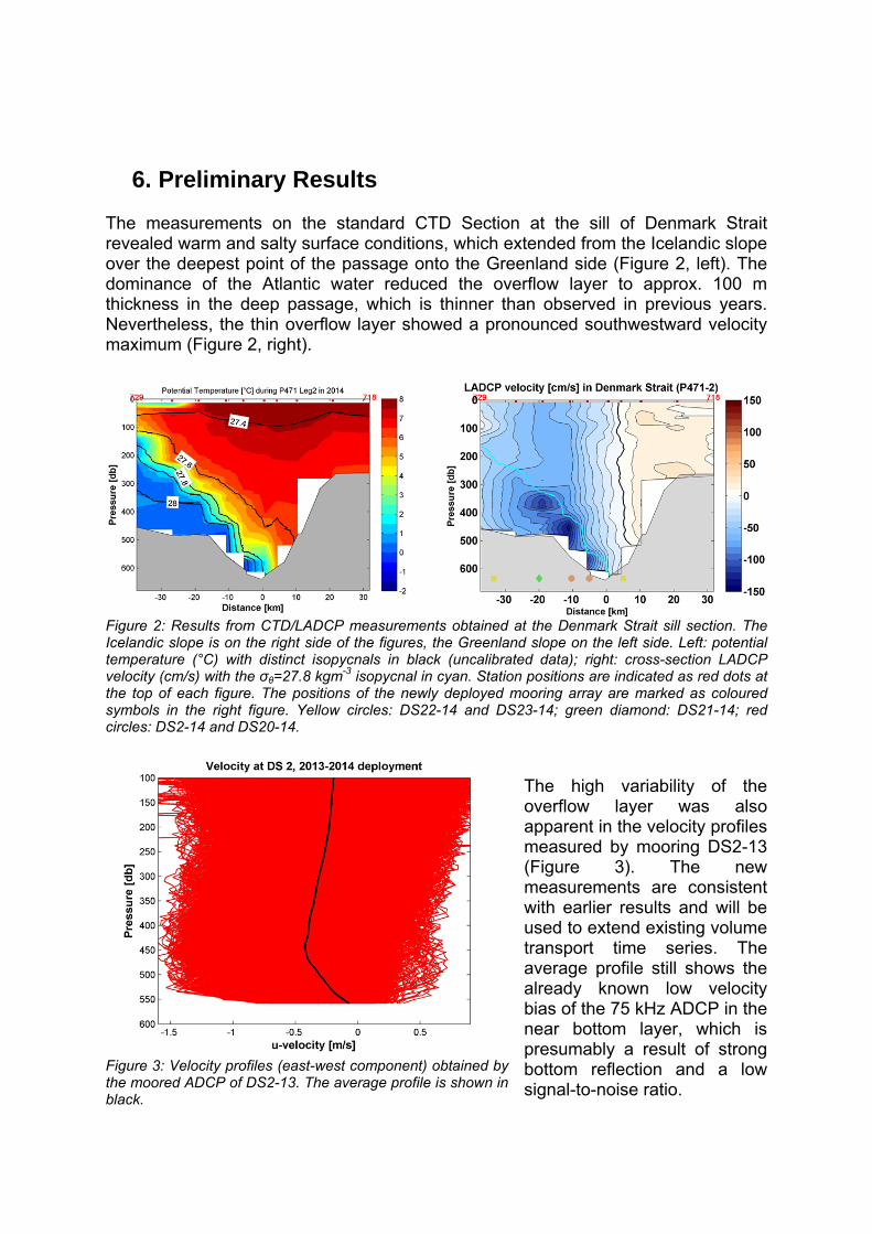
The measurements on the standard CTD Section at the sill of Denmark Strait revealed warm and salty surface conditions, which extended from the Icelandic slope over the deepest point of the passage onto the Greenland side (Figure 2, left). The dominance of the Atlantic water reduced the overflow layer to approx. 100 m thickness in the deep passage, which is thinner than observed in previous years. Nevertheless, the thin overflow layer showed a pronounced southwestward velocity maximum (Figure 2, right).
Figure 2: Results from CTD/LADCP measurements obtained at the Denmark Strait sill section. The Icelandic slope is on the right side of the figures, the Greenland slope on the left side. Left: potential temperature (°C) with distinct isopycnals in black (uncalibrated data); right: cross-section LADCP velocity (cm/s) with the σθ=27.8 kgm-3 isopycnal in cyan. Station positions are indicated as red dots at the top of each figure. The positions of the newly deployed mooring array are marked as coloured symbols in the right figure. Yellow circles: DS22-14 and DS23-14; green diamond: DS21-14; red circles: DS2-14 and DS20-14.
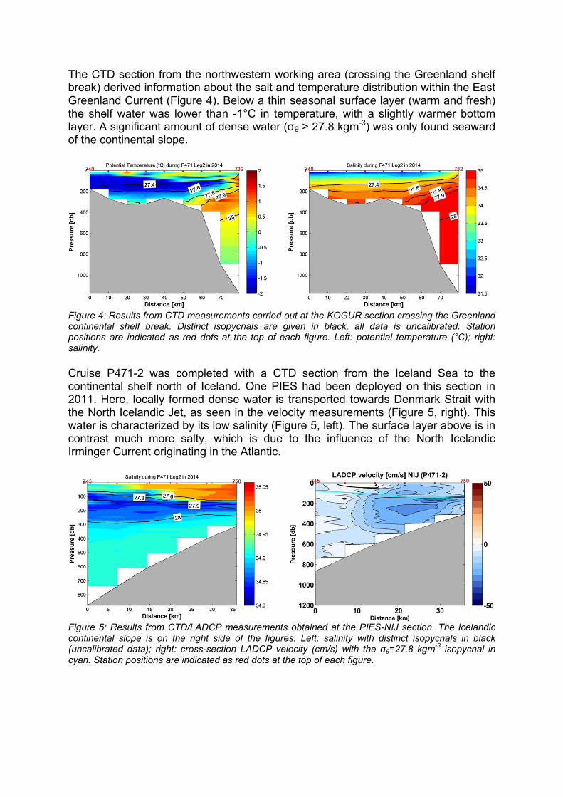
The high variability of the overflow layer was also apparent in the velocity profiles measured by mooring DS2-13 (Figure 3). The new measurements are consistent with earlier results and will be used to extend existing volume transport time series. The average profile still shows the already known low velocity bias of the 75 kHz ADCP in the near bottom layer, which is presumably a result of strong bottom reflection and a low signal-to-noise ratio.
Figure 3: Velocity profiles (east-west component) obtained by the moored ADCP of DS2-13. The average profile is shown in black.
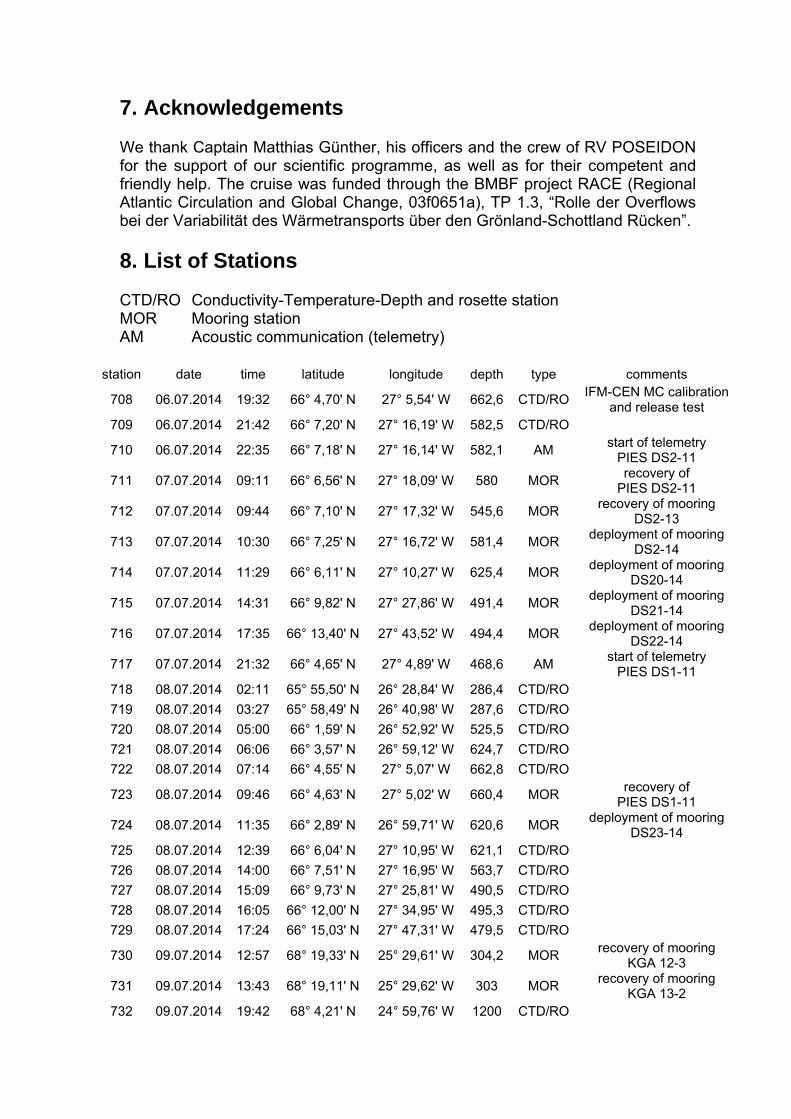
The CTD section from the northwestern working area (crossing the Greenland shelf break) derived information about the salt and temperature distribution within the East Greenland Current (Figure 4). Below a thin seasonal surface layer (warm and fresh) the shelf water was lower than -1°C in temperature, with a slightly warmer bottom layer. A significant amount of dense water (σθ > 27.8 kgm-3) was only found seaward of the continental slope.
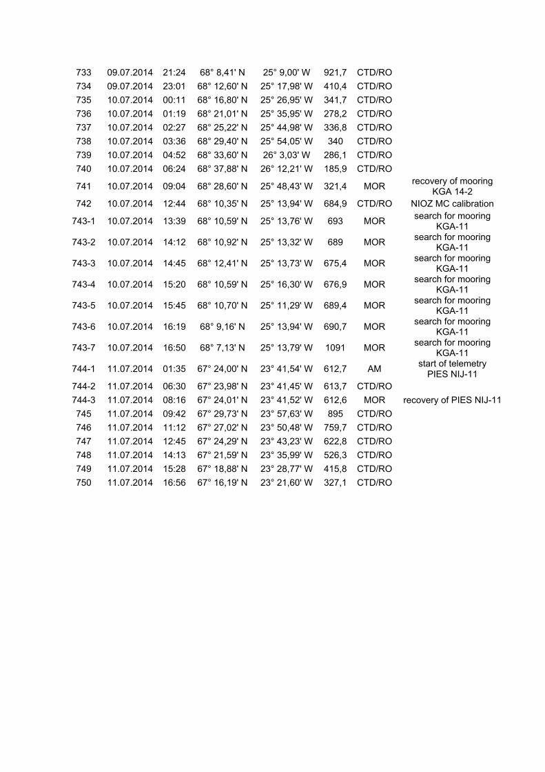
Figure 4: Results from CTD measurements carried out at the KOGUR section crossing the Greenland continental shelf break. Distinct isopycnals are given in black, all data is uncalibrated. Station positions are indicated as red dots at the top of each figure. Left: potential temperature (°C); right: salinity. Cruise P471-2 was completed with a CTD section from the Iceland Sea to the continental shelf north of Iceland. One PIES had been deployed on this section in 2011. Here, locally formed dense water is transported towards Denmark Strait with the North Icelandic Jet, as seen in the velocity measurements (Figure 5, right). This water is characterized by its low salinity (Figure 5, left). The surface layer above is in contrast much more salty, which is due to the influence of the North Icelandic Irminger Current originating in the Atlantic.
Figure 5: Results from CTD/LADCP measurements obtained at the PIES-NIJ section. The Icelandic continental slope is on the right side of the figures. Left: salinity with distinct isopycnals in black (uncalibrated data); right: cross-section LADCP velocity (cm/s) with the σθ=27.8 kgm-3 isopycnal in cyan. Station positions are indicated as red dots at the top of each figure.
7. Acknowledgements We thank Captain Matthias Günther, his officers and the crew of RV POSEIDON for the support of our scientific programme, as well as for their competent and friendly help. The cruise was funded through the BMBF project RACE (Regional Atlantic Circulation and Global Change, 03f0651a), TP 1.3, “Rolle der Overflows bei der Variabilität des Wärmetransports über den Grönland-Schottland Rücken”.
8. List of Stations CTD/RO Conductivity-Temperature-Depth and rosette station MOR Mooring station AM Acoustic communication (telemetry)
station date time latitude longitude depth type comments
708 06.07.2014 19:32 66° 4,70' N 27° 5,54' W 662,6 CTD/RO IFM-CEN MC calibration
and release test 709 06.07.2014 21:42 66° 7,20' N 27° 16,19' W 582,5 CTD/RO
710 06.07.2014 22:35 66° 7,18' N 27° 16,14' W 582,1 AM start of telemetry
PIES DS2-11
711 07.07.2014 09:11 66° 6,56' N 27° 18,09' W 580 MOR recovery of
PIES DS2-11
712 07.07.2014 09:44 66° 7,10' N 27° 17,32' W 545,6 MOR recovery of mooring
DS2-13
713 07.07.2014 10:30 66° 7,25' N 27° 16,72' W 581,4 MOR deployment of mooring
DS2-14
714 07.07.2014 11:29 66° 6,11' N 27° 10,27' W 625,4 MOR deployment of mooring
DS20-14
715 07.07.2014 14:31 66° 9,82' N 27° 27,86' W 491,4 MOR deployment of mooring
DS21-14
716 07.07.2014 17:35 66° 13,40' N 27° 43,52' W 494,4 MOR deployment of mooring
DS22-14
717 07.07.2014 21:32 66° 4,65' N 27° 4,89' W 468,6 AM start of telemetry
PIES DS1-11 718 08.07.2014 02:11 65° 55,50' N 26° 28,84' W 286,4 CTD/RO
719 08.07.2014 03:27 65° 58,49' N 26° 40,98' W 287,6 CTD/RO
720 08.07.2014 05:00 66° 1,59' N 26° 52,92' W 525,5 CTD/RO
721 08.07.2014 06:06 66° 3,57' N 26° 59,12' W 624,7 CTD/RO
722 08.07.2014 07:14 66° 4,55' N 27° 5,07' W 662,8 CTD/RO
723 08.07.2014 09:46 66° 4,63' N 27° 5,02' W 660,4 MOR recovery of
PIES DS1-11
724 08.07.2014 11:35 66° 2,89' N 26° 59,71' W 620,6 MOR deployment of mooring
DS23-14 725 08.07.2014 12:39 66° 6,04' N 27° 10,95' W 621,1 CTD/RO
726 08.07.2014 14:00 66° 7,51' N 27° 16,95' W 563,7 CTD/RO
727 08.07.2014 15:09 66° 9,73' N 27° 25,81' W 490,5 CTD/RO
728 08.07.2014 16:05 66° 12,00' N 27° 34,95' W 495,3 CTD/RO
729 08.07.2014 17:24 66° 15,03' N 27° 47,31' W 479,5 CTD/RO
730 09.07.2014 12:57 68° 19,33' N 25° 29,61' W 304,2 MOR recovery of mooring
KGA 12-3
731 09.07.2014 13:43 68° 19,11' N 25° 29,62' W 303 MOR recovery of mooring
KGA 13-2 732 09.07.2014 19:42 68° 4,21' N 24° 59,76' W 1200 CTD/RO
733 09.07.2014 21:24 68° 8,41' N 25° 9,00' W 921,7 CTD/RO
734 09.07.2014 23:01 68° 12,60' N 25° 17,98' W 410,4 CTD/RO
735 10.07.2014 00:11 68° 16,80' N 25° 26,95' W 341,7 CTD/RO
736 10.07.2014 01:19 68° 21,01' N 25° 35,95' W 278,2 CTD/RO
737 10.07.2014 02:27 68° 25,22' N 25° 44,98' W 336,8 CTD/RO
738 10.07.2014 03:36 68° 29,40' N 25° 54,05' W 340 CTD/RO
739 10.07.2014 04:52 68° 33,60' N 26° 3,03' W 286,1 CTD/RO
740 10.07.2014 06:24 68° 37,88' N 26° 12,21' W 185,9 CTD/RO
741 10.07.2014 09:04 68° 28,60' N 25° 48,43' W 321,4 MOR recovery of mooring
KGA 14-2 742 10.07.2014 12:44 68° 10,35' N 25° 13,94' W 684,9 CTD/RO NIOZ MC calibration
743-1 10.07.2014 13:39 68° 10,59' N 25° 13,76' W 693 MOR search for mooring
KGA-11
743-2 10.07.2014 14:12 68° 10,92' N 25° 13,32' W 689 MOR search for mooring
KGA-11
743-3 10.07.2014 14:45 68° 12,41' N 25° 13,73' W 675,4 MOR search for mooring
KGA-11
743-4 10.07.2014 15:20 68° 10,59' N 25° 16,30' W 676,9 MOR search for mooring
KGA-11
743-5 10.07.2014 15:45 68° 10,70' N 25° 11,29' W 689,4 MOR search for mooring
KGA-11
743-6 10.07.2014 16:19 68° 9,16' N 25° 13,94' W 690,7 MOR search for mooring
KGA-11
743-7 10.07.2014 16:50 68° 7,13' N 25° 13,79' W 1091 MOR search for mooring
KGA-11
744-1 11.07.2014 01:35 67° 24,00' N 23° 41,54' W 612,7 AM start of telemetry
PIES NIJ-11 744-2 11.07.2014 06:30 67° 23,98' N 23° 41,45' W 613,7 CTD/RO
744-3 11.07.2014 08:16 67° 24,01' N 23° 41,52' W 612,6 MOR recovery of PIES NIJ-11
745 11.07.2014 09:42 67° 29,73' N 23° 57,63' W 895 CTD/RO
746 11.07.2014 11:12 67° 27,02' N 23° 50,48' W 759,7 CTD/RO
747 11.07.2014 12:45 67° 24,29' N 23° 43,23' W 622,8 CTD/RO
748 11.07.2014 14:13 67° 21,59' N 23° 35,99' W 526,3 CTD/RO
749 11.07.2014 15:28 67° 18,88' N 23° 28,77' W 415,8 CTD/RO
750 11.07.2014 16:56 67° 16,19' N 23° 21,60' W 327,1 CTD/RO