Frühe kartographische Quellen zur Geschichte der Geologie in der
8
Berichte der Geologischen Bundesanstalt. ISSN 1017-8880, Band 35, Wien 1996 COOK Frühe kartographische Quellen zur Geschichte der Geologie in der Sammlung der British Library, London Early Geology Related Maps in the British Library, London Von / by Karen Severud COOK 59 mit 2 Abb. / with 2 fig. Schlüsselworte: Bergbaugeschichte Bibliotheksgeschichte British Museum British Library Geologie IGeschichte) Geologische Karten Großbritannien Indien Kartographie (Geschichte) London Manuskriptkarten Zusammenfassung: Das Britische Museum wurde 1753 gegründet, als die Sammlung des Arztes und Altertumsforschers Sir Hans SLOANE vom Staat erworben wurde. Vom An- fang an wurden für die Bibliothek des Museums Bü- cher und Karten zur Geologie gesammelt. Zunächst wurden die meisten geschenkt oder gekauft. Seit dem frühen 19. Jahrhundert wurden sie zusätzlich als Pflichtexemplare erworben. Seit 1973 eine selb- ständige Institution, stellt heute die British Library eine umfassende Forschungsbibliothek dar. Wegen der komplizierten Bestandsgeschichte ist es außeror- dentlich schwer, einschlägiges Material in den her- kömmlichen Katalogen zu identifizieren. Um dieses Hindernis bei meiner Forschungsarbeit zu frühen geologischen Karten zu überwinden, habe ich die Erwerbungssgeschichte der Bestände untersuchen müssen. Dabei war es unabdingbar, die Zusammen- stellung der verschiedenen Abteilungen zu begreifen. Zum Beispiel wurde bis 1968 die allgemeine Bücher- sammlung in Signaturreihen nach Sachgruppen auf- gesellt. Heute ist es möglich geworden, einschlägige Signaturgruppen maschinell zu untersuchen, da vor kurzem der Katalog gedruckter Bücher on-line zu- gänglich gemacht wurde. Auf diese Weise habe ich zahlreiche alte geologische Bücher identifizieren kön- nen, darunter einige, die geologische Karten enthalten. Die Konvertierung des Katalogs der Kartensamm- lung, an der zur Zeit gearbeitet wird, wird die Iden- tifizierung von blatt- und atlasförmigen Karten er- leichtern. In Verbindung mit diesem Automatisie- rungsprojekt wurde ein Register von handschriftli- chen Karten in der Sammlung der British Library zusammengestellt. Dieses Register enthält etwa 45 frühe Karten zum Bergbau bzw. zur Geologie. Es bleiben noch weitere Sammlungen in der British Library zu untersuchen, darunter die Bibliothek des ehemaligen Patentamtes sowie das Archiv des ehema- ligen Indienministeriums. Das Ziel dieser Forschungsarbeit wäre ein Gesamtka- talog der frühen geologischen Karten in allen Samm- lungen der British Library. Abstract: The British Museum and its library (now the separa- te British Library) were founded in 1753 when the collection of the physicisn and antiquary, Sir Hans SLOANE, was purchased for the nation after his death. Geology-related literature and maps have been acquired by the British Library throughout its histo- ry, at first largely by donation and purchase of royal or private collections. However, because the British Library is such a vast and complex general library, it can be difficult to locate older literature and maps on particular subjects, such as geology. Faced with this problem regarding my own research on early geological maps, I have found it useful to ex- plore the historical development of the British Library, its acquisition practices, and its various col- lections and departments. For example, the Depart- ment of Printed Books maintained subject-classified sequences of pressmarks until 1968. These press- mark sequences can now be searched by computer, using the recently automated British Library Catalo- gue, to locate old geological books, many of which in- clude geological maps. The ongoing automation of the British Library's map catalogues will also make it possible, by 1995, to locate geological maps and at- lases by on-line subject searching. Catalogue auto- mation at the British Library is thus making its older holdings almost as accessible by subject searching as are recent acquisitions. 1. Introduction The idea to produce a catalogue of early geology-related maps in the British Library was provoked by a conversati- on I overheard in 1989 at a symposium arranged by the Society for the History of Natural History in Bristol, Eng- land. The symposium met in memory of Victor and Joan EYLES, eminent historians of geology, whose collection of books and maps had recently been bequeathed to the Uni- versity of Bristol Library. As the participants crowded the exhibition of choice items from the bequest, someone remarked: 'This must be one of the most important col- lections of old geological maps and books in Great Bri- tain, along with the British Geological Survey Library, the Natural History Museum Library and the Geological 59 Anschrift der Verfasserin: COOK Karen S., Map Library, The British Library, Great Russell Street, London WCIB 3 DG, England Das kulturelle Erbe geo- und montanwissenschaftlicher Bibliotheken, Internationales Symposium, Freiberg (Sachsen) 71 ©Geol. Bundesanstalt, Wien; download unter www.geologie.ac.at
Transcript of Frühe kartographische Quellen zur Geschichte der Geologie in der
Berichte der Geologischen Bundesanstalt. ISSN 1017-8880, Band 35, Wien 1996 COOK
Frühe kartographische Quellen zur Geschichte der Geologie in
der Sammlung der British Library, London
Early Geology Related Maps in the British Library, London
Von / by
Karen Severud COOK 59
mit 2 Abb. / with 2 fig.
Schlüsselworte: Bergbaugeschichte Bibliotheksgeschichte British Museum British Library Geologie IGeschichte) Geologische Karten Großbritannien Indien Kartographie (Geschichte) London Manuskriptkarten
Zusammenfassung:
Das Britische Museum wurde 1753 gegründet, als die Sammlung des Arztes und Altertumsforschers Sir Hans SLOANE vom Staat erworben wurde. Vom Anfang an wurden für die Bibliothek des Museums Bücher und Karten zur Geologie gesammelt. Zunächst wurden die meisten geschenkt oder gekauft. Seit dem frühen 19. Jahrhundert wurden sie zusätzlich als Pflichtexemplare erworben. Seit 1973 eine selbständige Institution, stellt heute die British Library eine umfassende Forschungsbibliothek dar. Wegen der komplizierten Bestandsgeschichte ist es außerordentlich schwer, einschlägiges Material in den herkömmlichen Katalogen zu identifizieren.
Um dieses Hindernis bei meiner Forschungsarbeit zu frühen geologischen Karten zu überwinden, habe ich die Erwerbungssgeschichte der Bestände untersuchen müssen. Dabei war es unabdingbar, die Zusammenstellung der verschiedenen Abteilungen zu begreifen. Zum Beispiel wurde bis 1968 die allgemeine Büchersammlung in Signaturreihen nach Sachgruppen aufgesellt. Heute ist es möglich geworden, einschlägige Signaturgruppen maschinell zu untersuchen, da vor kurzem der Katalog gedruckter Bücher on-line zugänglich gemacht wurde. Auf diese Weise habe ich zahlreiche alte geologische Bücher identifizieren kön
nen, darunter einige, die geologische Karten enthalten.
Die Konvertierung des Katalogs der Kartensammlung, an der zur Zeit gearbeitet wird, wird die Identifizierung von blatt- und atlasförmigen Karten erleichtern. In Verbindung mit diesem Automatisierungsprojekt wurde ein Register von handschriftlichen Karten in der Sammlung der British Library zusammengestellt. Dieses Register enthält etwa 45 frühe Karten zum Bergbau bzw. zur Geologie. Es bleiben noch weitere Sammlungen in der British Library zu untersuchen, darunter die Bibliothek des ehemaligen Patentamtes sowie das Archiv des ehemaligen Indienministeriums.
Das Ziel dieser Forschungsarbeit wäre ein Gesamtkatalog der frühen geologischen Karten in allen Sammlungen der British Library.
Abstract: The British Museum and its library (now the separate British Library) were founded in 1753 when the collection of the physicisn and antiquary, Sir Hans SLOANE, was purchased for the nation after his death. Geology-related literature and maps have been acquired by the British Library throughout its history, at first largely by donation and purchase of royal or private collections. However, because the British Library is such a vast and complex general library, it can be difficult to locate older literature and maps on particular subjects, such as geology.
Faced with this problem regarding my own research on early geological maps, I have found it useful to explore the historical development of the British Library, its acquisition practices, and its various collections and departments. For example, the Department of Printed Books maintained subject-classified sequences of pressmarks until 1968. These pressmark sequences can now be searched by computer, using the recently automated British Library Catalogue, to locate old geological books, many of which include geological maps. The ongoing automation of the British Library's map catalogues will also make it possible, by 1995, to locate geological maps and atlases by on-line subject searching. Catalogue automation at the British Library is thus making its older holdings almost as accessible by subject searching as are recent acquisitions.
1. Introduction
The idea to produce a catalogue of early geology-related maps in the British Library was provoked by a conversation I overheard in 1989 at a symposium arranged by the Society for the History of Natural History in Bristol, England. The symposium met in memory of Victor and Joan EYLES, eminent historians of geology, whose collection of books and maps had recently been bequeathed to the University of Bristol Library. As the participants crowded the exhibition of choice items from the bequest, someone remarked: 'This must be one of the most important collections of old geological maps and books in Great Britain, along with the British Geological Survey Library, the Natural History Museum Library and the Geological
59 Anschrift der Verfasserin: COOK Karen S., Map Library, The British Library, Great Russell Street, London WCIB 3 DG, England
Das kulturelle Erbe geo- und montanwissenschaftlicher Bibliotheken, Internationales Symposium, Freiberg (Sachsen) 71
©Geol. Bundesanstalt, Wien; download unter www.geologie.ac.at
Berichte der Geologischen Bundesanstalt. ISSN 1017-8880. Band 35. Wien 1996 COOK
Society of London Library.' The British Library was omitted from the list, but I thought privately that it should have been included. Back in London this unspoken challenge led me to search the British Library's collections for older geology-related maps, a project still underway.
Another reason for compiling the catalogue is that London, despite its many libraries, offers relatively limited opportunities to see old geology-related maps. The most obvious location would be a specialist library. Of the ones already mentioned, the British Geological Survey Library, based at the Geological Museum in London until 1987, has been transferred to Survey headquarters near Nottingham and is now several hours distant. The Eyles Collection in the University of Bristol Library is equally remote from London. Although the libraries of the Natural History Museum and of the Geological Society of London hold some older geological material, access by outside researchers is limited. In contrast, the British Library is more readily accessible, but its vast general holdings are difficult to search for literature on a particular subject, such as geology. A catalogue of old geology-related maps in the British Library will be a useful finding aid.
2. Intended Coverage of the Catalogue
The catalogue will include geological maps and their precursors. Point symbols marking features like mineral deposits, mines or springs appeared on European maps from the Renaissance period onward. Large-scale plans of mine workings were also made. In the second half of the eighteenth century maps depicting the extent of different rocks by means of area outlines, patterns and colours became more common. The advance from differentiating rock types by composition alone to classifications also incorporating age and manner of origin led to the emergence of the modern geological map shortly after 1800. For geological maps, as for thematic cartography in general, the first half of the nineteenth century was an important formative period. The catalogue of early geology-related maps in the British Library will cover the period until 1850.
3. Map Collections in the British Library
Finding such maps requires detective work into the history and organization of the British Library collections. The British Museum was founded in 1753 when the vast private collection of natural specimens, human artefacts, graphic art, books and manuscripts gathered by the physician and naturalist, Sir Hans SLOANE, was purchased for the nation (BEER, pp. 176-223; BROOKS, pp. 108-153). The British Museum Library opened in 1759 and continued to grow by acquiring royal and private collections and individual items through donation, purchase and copyright deposit (STERNBERG, pp. 103-143; WEIMERSKIRCH, pp. 72-131). Maps formed a subordinate part of the British Museum Library's general collections, only becoming a separate Department of Maps and Charts briefly from 1867 to 1880. In 1892 the map holdings were divided between the Departments of Manuscripts and Printed Books. The Map Room stayed in the Department of Printed Books until after the British Library separated from the British Museum in 1973 (WAIÜS, pp. 17-18; MILLER,
1973, pp. 266-268, 271, 329). Re-named the Map Library, it became part of the new Special Collections directorate in 1987.
4. Map Library
Visitors to the British Library, unaware of the changing history of the map collections, come to the Map Library expecting to find that all maps are held there. Although this is not so, the Map Library's fifteen-volume Catalogue of Printed Maps, Charts and Plans (British Museum Catalogue) is still a good starting point when looking for early geology-related maps. A search of the catalogue for this purpose occupied several months of spare time. About 200 geology-related maps dated earlier than 1850 were found by looking under geographical headings and subject subheadings, such as 'ENGLAND: Geological maps' and 'AUSTRIA: Mining maps'. By 1995 the retrospective catalogue-automation project now underway will allow the rechecking of these findings by computer searching, as is already possible for cartographic material catalogued since 1975 (HUTT, pp. 8 - 9).
Of the early geology-related maps found in the Catalogue of printed maps, about 40% are English-language, 30% German, 20% French and the remaining 10% in other languages. The evidence of acquisition stamps and annotations on the items, as well as the surviving accession register for the period 1837 - 1849, indicates that that less than half of these maps were acquired before 1850 ([Accession] Register).
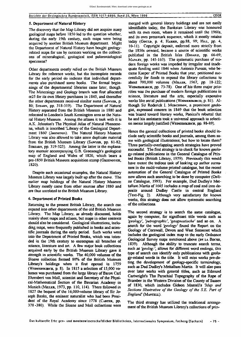
The earliest map acquisitions had come to the British Museum Library by donation or purchase. The Sloane Collection and other foundation collections included maps. However, the Topographical Collection of King George III, deposited in 1828, formed the main nucleus of a map collection, and its geographical arrangement became the model for organizing the general map collection thereafter. King George Ill's geopolitical concerns were evident in his collection of maps, atlases and views, which included much coverage of Britain, Europe and North America. One of the few 'thematic' maps he owned was Dr. Christopher PACKE'S 'Philosophico-chorogra-phical chart of East Kent', which represented the physical landscape as analogous to the human circulatory system and included some geological features (PACKE). The Kings Topographical Collection also includes the prospectus for Packe's map, which was published in 1743 (Text-Fig. 1).
During the 1830-s the Trustees of the British Museum instructed the Keeper of Printed Books, Antonio PAMZZL to purchase modern maps in order to improve and update the map collection. The purchases were mostly general geographical maps, although some British and German geological maps were purchased in the 1840s. Not until 1842 did the Copyright Act give the British Museum Library the right to receive new publications by legal deposit. As a result the earliest Ordnance Geological Survey maps of Cornwall, Devon and West Somerset, published in the 1830s, were not deposited in the British Museum Library at the time and have only recently been acquired by purchase ([DE LA BECBE, 1837 -1839).
Das kulturelle Erbe geo- und montanwissenschaftlicher Bibliotheken, Internationales Symposium, Freiberg (Sachsen) - 72 -
©Geol. Bundesanstalt, Wien; download unter www.geologie.ac.at

Berichte der Geologischen Bundesanstalt, ISSN 1017-8880, Band 35, Wien 1996 COOK
A
Fig. 1.
SPECIMEN crAc/o/op/icco c/wroarawAica/lCYlAKY
EAST-KENT
KJcalcL /ex ^tiauariiMfh.
c\S
Delineated and Prefented to the
R O Y A L SOCIETY j
C H R I S T O P H E R P A C K E MTX
PACKÜ, C: A specimen of a philosophico-chorographical chart of East-Kent as delineated and presented to the Royal Society by Christopher Packe, MD. - [London 1743]. The British Library Map Library: K.Top. 16.32-2. Reproduced by courtesy of the British Library.
Das kul turel le Erbe geo- und montanwissenschaft l icher Bib l iotheken, Internat ionales Symposium, Freiberg (Sachsen) - 73 -
©Geol. Bundesanstalt, Wien; download unter www.geologie.ac.at

©Geol. Bundesanstalt, Wien; download unter www.geologie.ac.at
Berichte der Geologischen Bundesanstalt, ISSN 1017-8880, Band 35. Wien 1996 COOK
5. Department of Natural History
The discovery that the Map Library did not acquire many geological maps before 1850 led to the question whether, during the early 19th century, such maps were being acquired by another British Museum department. Might the Department of Natural History have bought geology-related maps for use by curators working on the collections of mineralogical, geological and palaeontological specimens?
Other departments mostly relied on the British Museum Library for reference works, but the incomplete records for the early period do indicate that individual departments also purchased some books. The formal beginnings of the departmental libraries came later, though. The Mineralogy and Geology branch was first allocated oe25 for its own library purchases in 1845, and thereafter the other departments received similar sums (SAWYER, p. 80; STEARN, pp. 318-319). The Department of Natural History separated from the British Museum in 1880 and relocated to London's South Kensington area as the Natural History Museum. Among the atlases it took with it is A.K. Johnston's The Physical Atlas of Natural Phenomena, which is inscribed 'Library of the Geological Department I860' (JOHNSTON). The Natural History Museum Library was also allowed to take some duplicate material from the British Museum Library (SAWYER, pp. 81-82; STREARN, pp. 319-325). Among the latter is the explanatory memoir accompanying G.B. Greenough's geological map of England and Wales of 1820, which bears a pre-1850 British Museum acquisition stamp (GREENOUGH, 1820).
Despite such occasional examples, the Natural History Museum Library was largely built up after the move. The earlier map holdings of the Natural History Museum Library mostly came from other sources after 1880 and are thus unrelated to the British Museum Library.
6. Department of Printed Books
Returning to the present British Library, the search can expand into other departments of the old British Museum Library. The Map Library, as already discussed, holds mainly sheet maps and atlases, but maps in other contexts should also be considered. Geological illustrations, including maps, were frequently published in books and scientific journals during the early period. Such works went into the Department of Printed Books, which was intended in the 19th century to encompass all branches of science, literature and art. A few major book collections acquired early by the British Museum Library gave it strength in scientific works. The 40,000 volumes of the Sloane collection formed 80% of the British Museum Library's holdings when it first opened in 1759 (WEIMERSKKCH, p. 8). In 1815 a selection of 15,000 volumes was purchased from the large library of Baron Carl Ehrenbert von Moll, scientist and Secretary of the Physical-Mathematical Section of the Bavarian Academy in Munich (MUXER, 1973, pp. 110,114). There followed in 1827 the bequest of the 16,000-volume library of Sir Joseph Banks, the eminent naturalist who had been President of the Royal Academy since 1778 (CARTER, pp. 378 -380). While the Sloane and Moll collections were
merged with general library holdings and are not easily identifiable today, the Banksian Library was honoured with its own room, where it remained until the 1960s, and its own pressmark sequence, which it mostly retains today (GOULD, p. 4; HARRIS, pp.88, 99; HILL, pp. 4, 10-11). Copyright deposit, enforced more strictly from the 1850s onward, became a source of scientific works published in the British Isles (ESDAILE, pp. 66-69; MANLEY, pp. 145-163). The systematic purchase of modern foreign works was impeded by irregular and inadequate funding until 1846 when Antonio PANHZI, who became Keeper of Printed Books that year, petitioned successfully for funds to expand the library collections to about 700,000 volumes (MUXER, 1967, pp. 18-122; WEIMERSKIRCU, pp. 73-78). One of his three major priorities was the purchase of modern foreign publications in science, literature and the arts, especially expensive works like serial publications (WEEMERSKIRCH, p. 81). Although Sir Roderick I. MURCHKON, a prominent geologist, expressed concern in 1849 that the book selection was biased toward literary works, Panizzi's rebuttal that he and his assistants took a universal approach to selection seems largely justified (WEIMERSKIRCH, pp. 88-89).
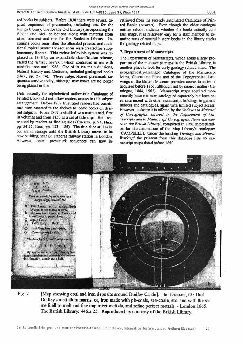
Hence the general collections of printed books should include early scientific books and journals, among them some with geological illustrations, but how to locate them? Three partially-overlapping search strategies have proved successful. The first strategy is to check for known geology-related publications in the General Catalogue of Printed Books (British Library, 1979). Previously this would have meant the tedious task of looking up author surnames in the multi-volume printed catalogue, but the recent automation of the General Catalogue of Printed Books now allows such searching to be done by computer (Online Catalogue, 1993). For example, Dud Dudley's Met-tallum Martis of 1665 includes a map of coal and iron deposits around Dudley Castle in central England (Text-Fig. 2). Although very satisfactory for known works, this strategy does not allow systematic searching of the collections.
The second strategy is to search the same catalogue, again by computer, for significant title words such as 'geology', 'petrographic', 'geognostische' and so on. A search for the word 'geology' found the Report on the Geology of Cornwall, Devon and West Somerset which includes the geological index map to the early Ordnance Geological Survey maps mentioned above (DE LA BECHE, 1839). Although the ability to truncate search terms, such as 'geolog:', allows for different word endings, this type of search can identify only publications with geology-related words in the title. It will miss works pre-da-ting the development of geology-specific terminology, such as Dud Dudley's Mettallum Martis. It will also pass over later works with general titles, such as Edmund Cartwright's The Parochial Topography of the Rape of Bramber in the Western Division of the County of Sussex of 1830, which includes Gideon Mantell's 'Map and Sections Illustrative of the Geology of the S.E. Part of England' (MANTELL).
The third strategy has utilized the traditional arrangement of the British Museum Library's collections of prin-
Das kulturelle Erbe geo- und montanwissenschaftlicher Bibliotheken, Internationales Symposium, Freiberg (Sachsen) - 75 -
©Geol. Bundesanstalt, Wien; download unter www.geologie.ac.at
Berichte der Geologischen Bundesanstalt, ISSN 1017-8880, Band 35, Wien 1996 COOK
ted books by subjects. Before 1838 there were several topical sequences of pressmarks, including one for the King's Library, one for the Old Library (incorporating the Sloane and Moll collections along with material from other sources) and one for the Banksian Library. Incoming books soon filled the allocated presses, and additional topical pressmark sequences were created for Supplementary Rooms. This rather inflexible system was replaced in 1848 by an expandable classification scheme, called the 'Elastic System', which continued in use with modifications until 1968. One of its ten main divisions, Natural History and Medicine, included geological books (HILL, pp. 2 - 74). These subject-based pressmark sequences survive today, although new books are no longer being placed in them.
Until recently the alphabetical author-title Catalogue of Printed Books did not allow readers access to this subject arrangement. Before 1807 frustrated readers had sometimes been escorted to the shelves to locate books on desired subjects. From 1807 a shelflist was maintained, first in volumes and from 1850 as a set of title slips. Both were used by readers as finding aids (CHAPLIN, p. 94; HILL,
pp. 54-55; KING, pp. 183 - 185). The title slips still exist but are in storage until the British Library moves to its new building near St. Pancras railway station in London. However, topical pressmark sequences can now be
retrieved from the recently automated Catalogue of Printed Books (ALSTON). Even though the older catalogue entries seldom indicate whether the books actually contain maps, it is relatively easy for a staff member to examine runs of natural history books in the library stacks for geology-related maps.
7. Department of Manuscripts
The Department of Manuscripts, which holds a large proportion of the manuscript maps in the British Library, is another place to look for early geology-related maps. The geographically-arranged Catalogue of the Manuscript Maps, Charts and Plans and of the Topographical Drawings in the British Museum provides access to material acquired before 1861, although not by subject matter (Catalogue, 1844, 1962). Manuscript maps acquired more recently have not been catalogued separately but have been intermixed with other manuscript holdings in general indexes and catalogues, again with limited subject access. However, a shortcut is offered by the 'Indexes to Material of Cartographic Interest in the Department of Manuscripts and to Manuscript Cartographic Items elsewhere in the British Library1, completed in 1991 in preparation for the automation of the Map Library's catalogues (CAMPBELL). Under the heading 'Geology and Mineral Working' the printout from this database lists 45 manuscript maps dated before 1850.
Fig. 2 [Map showing coal and iron deposits around Dudley Castle]. - In: DUDLEY, D.: Dud Dudley's mettallum martis: or, iron made with pit-coale, sea-coale, etc. and with the same fuell to melt and fine imperfect mettals, and refine perfect mettals. - London 1665. The British Library: 446.a.25. Reproduced by courtesy of the British Library.
Das kulturelle Erbe geo- und montanwissensehaftlicher Bibliotheken. Internationales Symposium. Freiberg (Sachsen) - 76 -
©Geol. Bundesanstalt, Wien; download unter www.geologie.ac.at
Berichte der Geologischen Bundesanstalt. ISSN 1017-8880, Band
8. Science Reference and Information Service
All of the departments and collections mentioned so far formed part of the original British Museum Library. More recently the British Library has acquired the libraries and archives of several other organizations, which have had separate acquisition histories and may equally hold early geological literature. The British Library's science division, known as the Science Reference and Information Service, focuses primarily on current scientific literature, but it also incorporates the older holdings of the former Patent Office Library. There is a printed multi-volume, author/title catalogue to the Patent Office Library, but more helpful to the present search is the topical arrangement of its pressmarks. As with the general library collections discussed above, it will be possible to examine runs of subject-based pressmarks for early geology books.
9. India Office Records
The India Office Records, now part of the Oriental and India Office Collections of the British Library, is also a possible source of early geology-related maps. The India Office Records comprises the archives of the East India Company and the British government in India, which were transferred from the Foreign Office to the British Library in 1971. The India Office map collection and official files certainly contain records of investigations into the geology of India. It is known, for example, that G.B. Greenough used information held in the India Office when compiling his geological map of India published in 1855 (GREENOUGH, 1855).
10. Conclusion
In conclusion, the contents of the British Library form a valuable resource for the history of the earth sciences, but conventional reader access through author/title catalogues is not the most efficient way to locate this material. Modern computer technology can probe the old catalogues in new ways, such as by searching for significant words and for subject-based pressmarks. Used to help create a catalogue of early geology-related maps in the British Library, automation is making the collections more accessible to historians of geology.
Acknowledgements
Thanks are due to colleagues, especially to Robin Alston for advice about computer searching subject-based pressmarks in the Department of Printed Books, to Peter Barber for guidance to finding aids in the Department of Manuscripts and to Graham Jefcoate for translating the abstract. I am also grateful to the British Library for providing the photographs for illustrations.
References
[Accession] Register. Maps, charts and plans. Feb. 11, 1837 to June 8, 1849. - [London (The British Museum Library)] 1837-1849. The British Library Map Library Archives.
ALSTON, R.C.: A topical guide to pressmarks in use in the British Museum Library (1823-1973) and the Bri-
Das kulturelle Erbe geo- und montanwissenschaftlicher Bibliotheken,
35, Wien 1996 COOK
tish Library (1973-1985). - 598 pp., [London (R.C. Aiston)] 1987.
The British Library general catalogue of printed books to 1975. - 360 vols., London (Clive Bingley; K.G. Saur) 1979.
The British Museum catalogue of printed maps, charts and plans ... complete to 1964. - 15 vols., London (The British Museum) 1967; Ten-year supplement 1965-1974. - 1 vol., London (The British Library) 1977.
BROOKS, E.St.J.: Sir Hans SLOANE: the great collector and his circle. - 234 p., [9 plates] London (Batchworth Press) 1954.
CAMPBELL, T.: Indexes to material of cartographic interest in the Department of Manuscripts and to manuscript cartographic items elsewhere in the British Library. - 1048 pp., London (The British Library Map Library) 1992.
CARTER, H.B.: Sir Joseph Banks 1743-1820. - 670 p., [80 plates] London (British Museum (Natural History)) 1988.
Catalogue of manuscript maps, charts and plans and of the topographical drawings in the British Museum. - 3 vols., London (The British Museum) 1844, 1962.
CHAPLIN, A.H.: GK: 150 years of the General catalogue of printed books in the British Museum. - 177 pp., [13 text-figs.] Aldershot (Scolar Press) 1987.
DE BEER, G.R.: Sir Hans Sloane and the British Museum. -192 p., [11 plates] London (Oxford University Press) 1953.
DELABECHE, H.T.: [Geological maps of Devon, Cornwall and West Somerset. - 2nd issue, partly 2nd. ed. -London (Ordnance Survey) 1837-1839]. The British Library Map Library: *2121.(24.).
DELABECHE, H.T.: Report on the geology of Cornwall, Devon and West Somerset. -[ 73 pp., fig. 1,] London (Longman & Co.) 1839. The British Library: B.S.38.Ga./l.(3.).
ESDAILE, A.: The British Museum Library: a short history and survey. - 388 p., London (George Allen & Un-win) 1946.
GOULD, A.: Named special collections in the Department of Printed Books. Reader guide No. 9. - 27 pp., London (The British Library), 1981.
GREENOUGH, G.B.: General sketch of the physical and geological features of British India. - London (E. Stanford) 1855. Natural History Museum: Map Library.
GREENOUGH, G.B.: Memoir of a geological map of England: to whihch are added, an alphabetical index to the hills arranged according to counties. -17. pp., London (Geological Society) 1820.
Internationales Symposium, Freiberg (Sachsen) - 77 -
©Geol. Bundesanstalt, Wien; download unter www.geologie.ac.at
Berichte der Geologischen Bundesanstalt. ISSN 1017-8880, Band 35. Wien 1996 COOK
HARRIS, PR.: The move of Printed Books from Montagu House, 1838-42. - In: HARRIS, P.R. (ed.): The Library of the British Museum: retrospective essays on the Department of Printed Books. - London (The British Library) 1991, pp. 75-101 [5 text-figs.].
HILL, F.J.: The shelving and classification of printed books. - In: HARRIS, P.R. (ed.): The Library of the British Museum: retrospective essays on the Department of Printed Books. - London (The British Library) 1991, pp. 1-74 [5 text-figs.].
HUTT, G.: Maps retroconversion in the British Library. -Mapping Awareness & G.I.S. in Europe, 6, No. 10, 8-9. London 1992.
JOHNSTON, A.K.: The physical atlas of natural phenomena. - 137 pp., [7 text-figs., 35 plates] Edinburgh and London (William Blackwood and Sons) 1856. Natural History Museum: Map Library.
KING, A.H.: The traditional maintenance of the General catalogue of printed books. - In: HARRIS, P.R. (ed.): The Library of the British Museum: retrospective essays on the Department of Printed Books. - London (The British Library) 1991, pp. 165-199 [6 text-figs.].
MANLEY, K.A.: The book wolf bites a Bohn: Panizzi, Henry Bohn and legal deposit. - In: HARRIS, P.R. (ed.): The Library of the British Museum: retrospective essays on the Department of Printed Books. - London (The British Library) 1991, pp. 145-164 [2 text-figs.].
MANTELL, G.A.: The geological structure of the Rape of Bramber. - In: CARTWRIGHT, E.: The parochial topography of the Rape of Bramber in the Western Division of the County of Sussex. - London (J.B. Nichols and Son) 1830, pp. i-xvi [1 map].
MILLER, E.: Prince of librarians: the life & times of Antonio Panizzi of the British Museum. - 356 pp., [8 plates]. London (Andre Deutsch) 1967.
MILLER, E.: That noble cabinet: a history of the British Museum. - 400 p., [16 plates] London (Andre Deutsch) 1973.
The online catalogue. - The British Library London Services - Bloomsbury newsletter, 7, Summer, [1-2], London 1993.
PACKE, C : A new philosophico-chorographical chart of East-Kent. - [London] 1743. The British Library Map Library: K.Top.l6.24.,ll.Tab.End.
Plan of the Library (in 1914). - In: HARRIS, P.R. (ed.): The Library of the British Museum: retrospective essays on the Department of Printed Books. - London (The British Library) 1991, pp. xii-xiii.
SAWYER, F.C.: A short history of the libraries and list of mansucripts and original drawings in the British Museum (Natural History). - Bulletin of the British Museum (Natural History) Historical, 4, no. 2, 1-201, [1 plate] London 1971.
STEARN, W.: The Natural History Museum at South Kensington. - 414 p., [88 plates] London (Heinemann) 1981.
STERNBERG, I.: The acquisitions policies and funding of the Department of Printed Books, 1837-1959. In: Harris, P.R. (ed.): The Library of the British Museum: retrospective essays on the Department of Printed Books. - London (The British Library) 1991, pp. 103-143 [3 text-figs.].
WALLIS, H.: The map collections of the British Museum Library. In: WALLIS, H. & TYACKE, S. (eds.): My head is a map: essays & memoirs in honour of R.V. Tooley. - London (Francis Edwards and Carta Press) 1953, pp. 3-20.
WETMERSKIRCH, J.P.: Antonio Panizzi's acquisition policies for the British Museum. - 339 p., New York (Columbia University, Ph.D. diss.) 1977.
Das kulturelle Erbe geo- und montanwissenschaftlicher Bibliotheken. Internationales Symposium. Freiberg (Sachsen) - 78 -
©Geol. Bundesanstalt, Wien; download unter www.geologie.ac.at