GEOGRAPHIC INFORMATION SYSTEM AND REMOTE SENSING …
8
GEOGRAPHIC INFORMATION SYSTEM AND REMOTE SENSING BASED DISASTER MANAGEMENT AND DECISION SUPPORT PLATFORM: AYDES İ. Keskin 1* , N. Akbaba 2 , M. Tosun 3 , M.K. Tüfekçi 4 , D. Bulut 5 , F. Avcı 6 , O.Gökçe 7 Republic of Turkey, Prime Ministry, Disaster and Emergency Management Authority (AFAD), Ankara, Turkey 1 [email protected] 2 [email protected] 3 [email protected] 4 [email protected] 5 [email protected] 6 [email protected] 7 [email protected] KEY WORDS: Disaster Management, Decision Support System, Geographic Information System, Remote Sensing, AYDES ABSTRACT: The accelerated developments in information technology in recent years, increased the amount of usage of Geographic Information Systems (GIS) and Remote Sensing (RS) in disaster management considerably and the access from mobile and web-based platforms to continuous, accurate and sufficient data needed for decision-making became easier accordingly. The Disaster Management and Decision Support System (AYDES) has been developed with the purpose of managing the disaster and emergency management processes effectively and creating a management model based on an IT infrastructure and a decision support system required for both pre-disaster risk reduction & preparation and post-disaster respond & recovery stages. The system is a holistic platform integrated with many internal and external systems and services, including desktop, mobile and web-based applications that utilize GIS and RS technologies. AYDES has been prepared especially according to the content of the National Disaster Response Plan of Turkey and designed to be easily used by the Disaster and Emergency Management Authority (AFAD), collaborative Ministries, private institutions and provincial organizations. AYDES is an integrated framework enabling the execution of processes effectively. AYDES already has approximately 6,200 active users from the central and provincial organizations of AFAD and other public institutions and organizations. AYDES consists of three core components with their sub components, namely "Incident Command System", "Spatial Information System" and "Recovery Information System". Mobile software tools that can deliver real-time information to the web-based core components of AYDES that consists of applications used for mapping during both post-disaster damage detection and pre-disaster risk reduction. Additionally, in case of a need to disaster event inventories, potentially vulnerable assets, hazard - risk data, affected areas of probable or actual disasters, damage detection results and such data and analyses, two software tools have been developed, namely AYDES-RS, a desktop image processing and analysis software and AYDES-CS, a web-based crowdsourcing software tool whereas two of them enable to allow the use of imagery acquired by remote (space/aerial) technologies for various analyses before and after a disaster. AYDES is a software, data and analysis platform that provide accurate and current disaster and emergency data, reports, statistics, job inspections, queries, analyses etc. at every stages before and after the disaster. 1. INTRODUCTION Disaster Management and Decision Support System (AYDES) is an information system which is developed for performing the processes of disaster and emergency management efficiently. The system is an integral platform connected to other internal and external systems and applications and composed of desktop software, GIS based web applications (2D and 3D) and mobile applications. AYDES is prepared properly to the content of Turkey Disaster Response Plan (TAMP). The system presents a holistic approach for effective and easy usage in disaster management processes and is designed to be used by Disaster and Emergency Management Presidency (AFAD), relevant ministries and provincial organizations. AYDES consists of three main components as “Incident Command System”, “Spatial Information System”, “Recovery Information System” and subcomponents belong to these (Figure 1). * Corresponding author Figure 1. System components of AYDES Mobile software tools that can deliver real-time information to the web-based main modules are developed in accordance with the field data collection and consist of applications used in mapping studies within the scope of risk mitigation as well as post-disaster damage detection. In addition, disaster event The International Archives of the Photogrammetry, Remote Sensing and Spatial Information Sciences, Volume XLII-3/W4, 2018 GeoInformation For Disaster Management (Gi4DM), 18–21 March 2018, Istanbul, Turkey This contribution has been peer-reviewed. https://doi.org/10.5194/isprs-archives-XLII-3-W4-283-2018 | © Authors 2018. CC BY 4.0 License. 283
Transcript of GEOGRAPHIC INFORMATION SYSTEM AND REMOTE SENSING …
GEOGRAPHIC INFORMATION SYSTEM AND REMOTE SENSING BASED
DISASTER MANAGEMENT AND DECISION SUPPORT PLATFORM: AYDES
İ. Keskin 1*, N. Akbaba 2 , M. Tosun 3 , M.K. Tüfekçi 4, D. Bulut 5, F. Avcı 6 , O.Gökçe 7
Republic of Turkey, Prime Ministry, Disaster and Emergency Management Authority (AFAD), Ankara, Turkey
1 [email protected] 2 [email protected] 3 [email protected]
4 [email protected] 5 [email protected]
6 [email protected] 7 [email protected]
KEY WORDS: Disaster Management, Decision Support System, Geographic Information System, Remote Sensing, AYDES
ABSTRACT:
The accelerated developments in information technology in recent years, increased the amount of usage of Geographic Information
Systems (GIS) and Remote Sensing (RS) in disaster management considerably and the access from mobile and web-based platforms
to continuous, accurate and sufficient data needed for decision-making became easier accordingly.
The Disaster Management and Decision Support System (AYDES) has been developed with the purpose of managing the disaster
and emergency management processes effectively and creating a management model based on an IT infrastructure and a decision
support system required for both pre-disaster risk reduction & preparation and post-disaster respond & recovery stages. The system
is a holistic platform integrated with many internal and external systems and services, including desktop, mobile and web-based
applications that utilize GIS and RS technologies. AYDES has been prepared especially according to the content of the National
Disaster Response Plan of Turkey and designed to be easily used by the Disaster and Emergency Management Authority (AFAD),
collaborative Ministries, private institutions and provincial organizations. AYDES is an integrated framework enabling the execution
of processes effectively. AYDES already has approximately 6,200 active users from the central and provincial organizations of
AFAD and other public institutions and organizations.
AYDES consists of three core components with their sub components, namely "Incident Command System", "Spatial Information
System" and "Recovery Information System". Mobile software tools that can deliver real-time information to the web-based core
components of AYDES that consists of applications used for mapping during both post-disaster damage detection and pre-disaster
risk reduction. Additionally, in case of a need to disaster event inventories, potentially vulnerable assets, hazard - risk data, affected
areas of probable or actual disasters, damage detection results and such data and analyses, two software tools have been developed,
namely AYDES-RS, a desktop image processing and analysis software and AYDES-CS, a web-based crowdsourcing software tool
whereas two of them enable to allow the use of imagery acquired by remote (space/aerial) technologies for various analyses before
and after a disaster. AYDES is a software, data and analysis platform that provide accurate and current disaster and emergency data,
reports, statistics, job inspections, queries, analyses etc. at every stages before and after the disaster.
1. INTRODUCTION
Disaster Management and Decision Support System (AYDES)
is an information system which is developed for performing the
processes of disaster and emergency management efficiently.
The system is an integral platform connected to other internal
and external systems and applications and composed of desktop
software, GIS based web applications (2D and 3D) and mobile
applications. AYDES is prepared properly to the content of
Turkey Disaster Response Plan (TAMP). The system presents a
holistic approach for effective and easy usage in disaster
management processes and is designed to be used by Disaster
and Emergency Management Presidency (AFAD), relevant
ministries and provincial organizations. AYDES consists of
three main components as “Incident Command System”,
“Spatial Information System”, “Recovery Information System”
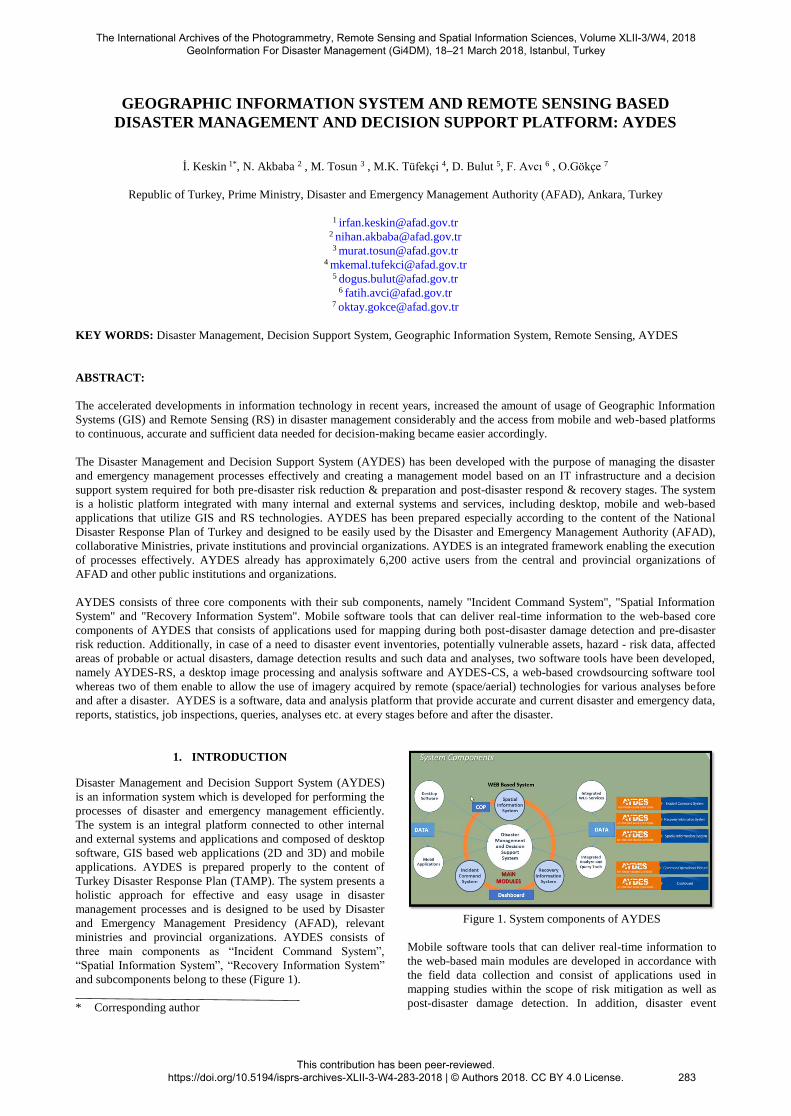
and subcomponents belong to these (Figure 1).
* Corresponding author
Figure 1. System components of AYDES
Mobile software tools that can deliver real-time information to
the web-based main modules are developed in accordance with
the field data collection and consist of applications used in
mapping studies within the scope of risk mitigation as well as
post-disaster damage detection. In addition, disaster event
The International Archives of the Photogrammetry, Remote Sensing and Spatial Information Sciences, Volume XLII-3/W4, 2018 GeoInformation For Disaster Management (Gi4DM), 18–21 March 2018, Istanbul, Turkey
This contribution has been peer-reviewed. https://doi.org/10.5194/isprs-archives-XLII-3-W4-283-2018 | © Authors 2018. CC BY 4.0 License.
283
inventories, potentially vulnerable assets, hazard - risk data,
areas of probable or actual disasters, etc. AYDES-RS "desktop
image processing and analysis software and AYDES – Crowd
Sourcing software have been developed for the use of remote
(space / air) sensing technologies in various analyses before and
after disasters.
AYDES is a software and data platform that provide accurate
and current disaster and emergency data, reports, statistics, job
inspections, queries, analyses etc. at every stages before and
after the disaster.
2. MAIN COMPONENTS
The main features and scope of the AYDES main components
are summarized below.
2.1 Incident Command System
Incident Command System (ICS) is an AYDES component
which allows the holistic management of the processes of
disaster preparation, planning and response phases that are
described in TAMP. Software based management model
supports disaster and emergency preparedness and response
activities at the local and national level through the main
management processes (resource management, transport,
demand management) flexibly and effectively. When a disaster
event occurs at national or local level, event notifications can be
sent to teams by SMS and e-mail so that via the instant
messaging and e-mail, service groups (defined as part of
TAMP) can remain in continuous interaction and
communication. Data pool and data analysis framework was set
up so that 28 service groups could process the processes related
to their own specialization fields and data that could be needed
in the management of service groups could be entered into the
system during various stages of disaster.
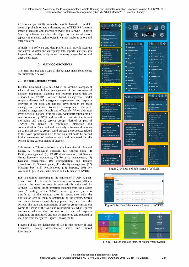
Sub-menus in ICS are as follows: (1) Incident identification and
listing, (2) Organization structure, (3) Address book, (4)
Facility management, (5) TAMP documentation, (6) Service
Group Recovery procedures, (7) Resource management, (8)
Demand management, (9) Transportation and transfer
operations, (10) Scenario panel, (11) Identity management, (12)
Message box, (13) Notifications, (14) Reports, (16) My
Account. Figure 2 shows the menus and sub-menus of AYDES.
ICS is designed according to the content of TAMP. A post-
disaster use of ICS can be summarized as follows. After a
disaster, the need estimate is automatically calculated by
AYDES ICS using the information obtained from the disaster
area. According to the TAMP, service groups system is
transferred to the disaster area in accordance with the
notification sent to them automatically by the system. Search
and rescue teams demand the equipment they need from the
system. The tasks and transactions of service groups carried out
within the scope of the tasks and responsibilities, what requests
are made, whether they are met or not and all response
operations are monitored and can be monitored and reported in
real time from the system. Figure 3 shows the ICS.
Figures 4 shows the dashboards of ICS for the number of total
evacuated, identity determination status and injured
information.
Figure 2. Menus and Sub-menus of AYDES
Figure 3. Incident Management System of AYDES
Figure 4. Dashboards of Incident Management System
The International Archives of the Photogrammetry, Remote Sensing and Spatial Information Sciences, Volume XLII-3/W4, 2018 GeoInformation For Disaster Management (Gi4DM), 18–21 March 2018, Istanbul, Turkey
This contribution has been peer-reviewed. https://doi.org/10.5194/isprs-archives-XLII-3-W4-283-2018 | © Authors 2018. CC BY 4.0 License.
284
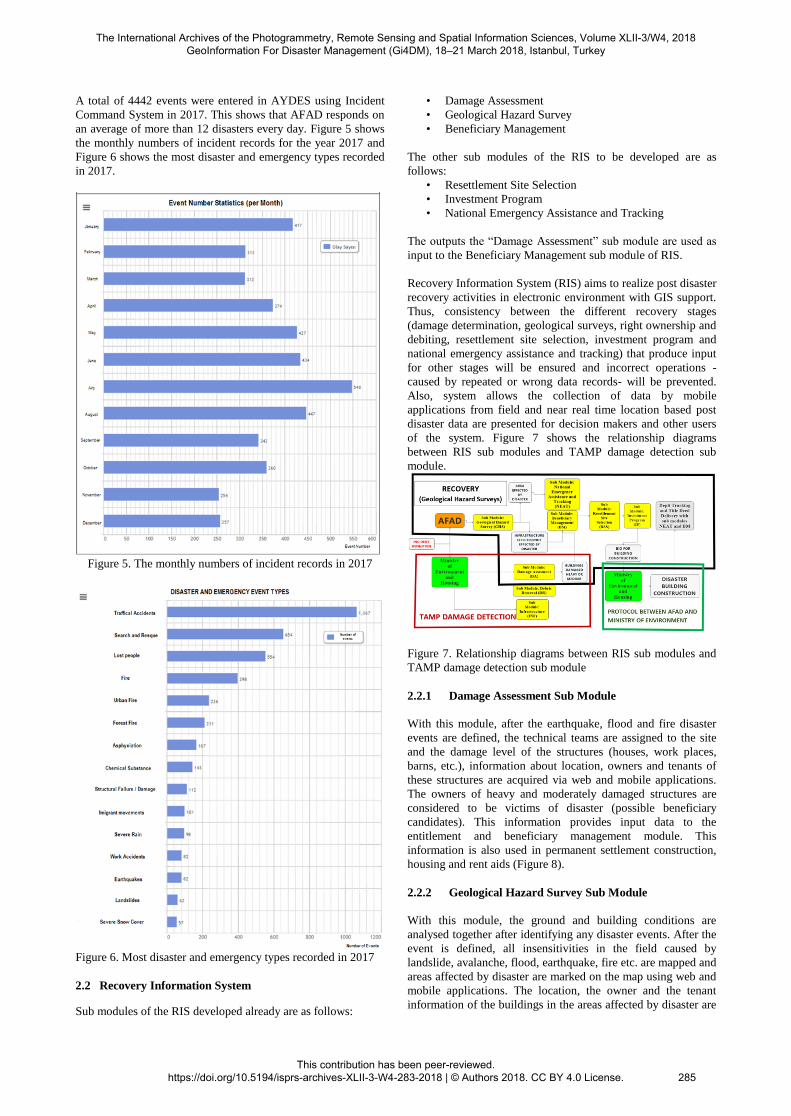
A total of 4442 events were entered in AYDES using Incident
Command System in 2017. This shows that AFAD responds on
an average of more than 12 disasters every day. Figure 5 shows
the monthly numbers of incident records for the year 2017 and
Figure 6 shows the most disaster and emergency types recorded
in 2017.
Figure 5. The monthly numbers of incident records in 2017
Figure 6. Most disaster and emergency types recorded in 2017
2.2 Recovery Information System
Sub modules of the RIS developed already are as follows:
• Damage Assessment
• Geological Hazard Survey
• Beneficiary Management
The other sub modules of the RIS to be developed are as
follows:
• Resettlement Site Selection
• Investment Program
• National Emergency Assistance and Tracking
The outputs the “Damage Assessment” sub module are used as
input to the Beneficiary Management sub module of RIS.
Recovery Information System (RIS) aims to realize post disaster
recovery activities in electronic environment with GIS support.
Thus, consistency between the different recovery stages
(damage determination, geological surveys, right ownership and
debiting, resettlement site selection, investment program and
national emergency assistance and tracking) that produce input
for other stages will be ensured and incorrect operations -
caused by repeated or wrong data records- will be prevented.
Also, system allows the collection of data by mobile
applications from field and near real time location based post
disaster data are presented for decision makers and other users
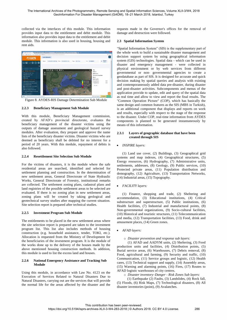
of the system. Figure 7 shows the relationship diagrams
between RIS sub modules and TAMP damage detection sub
module.
Figure 7. Relationship diagrams between RIS sub modules and
TAMP damage detection sub module
2.2.1 Damage Assessment Sub Module
With this module, after the earthquake, flood and fire disaster
events are defined, the technical teams are assigned to the site
and the damage level of the structures (houses, work places,
barns, etc.), information about location, owners and tenants of
these structures are acquired via web and mobile applications.
The owners of heavy and moderately damaged structures are
considered to be victims of disaster (possible beneficiary
candidates). This information provides input data to the
entitlement and beneficiary management module. This
information is also used in permanent settlement construction,
housing and rent aids (Figure 8).
2.2.2 Geological Hazard Survey Sub Module
With this module, the ground and building conditions are
analysed together after identifying any disaster events. After the
event is defined, all insensitivities in the field caused by
landslide, avalanche, flood, earthquake, fire etc. are mapped and
areas affected by disaster are marked on the map using web and
mobile applications. The location, the owner and the tenant
information of the buildings in the areas affected by disaster are
The International Archives of the Photogrammetry, Remote Sensing and Spatial Information Sciences, Volume XLII-3/W4, 2018 GeoInformation For Disaster Management (Gi4DM), 18–21 March 2018, Istanbul, Turkey
This contribution has been peer-reviewed. https://doi.org/10.5194/isprs-archives-XLII-3-W4-283-2018 | © Authors 2018. CC BY 4.0 License.
285
collected via the interfaces of this module. This information
provides input data to the entitlement and debit module. This
information also provides input data to the entitlement and debit
module. This information is also used in housing, housing and
rent aids.
Figure 8. AYDES-RIS Damage Determination Sub Module
2.2.3 Beneficiary Management Sub Module
With this module, Beneficiary Management commission,
created by AFAD’s provincial directorate, evaluates the
beneficiary management of the disaster victims using the
outputs of damage assessment and geological hazard survey
modules. After evaluation, they prepare and approve the name
lists of the beneficiary disaster victims. Disaster victims who are
deemed as beneficiary shall be debited for no interest for a
period of 20 years. With this module, repayment of debits is
also followed.
2.2.4 Resettlement Site Selection Sub Module
For the victims of disasters, it is the module where the safe
residential areas are searched, identified and selected for
settlement planning and construction. In the determination of
new settlement areas, General Directorate of State Hydraulic
Works, General Directorate of Forestry, institutional remarks
are collected. The settlement zoning plans, cadastral plans and
land registries of the possible settlement areas to be selected are
evaluated. If there is no zoning plan in new settlement areas,
zoning plans will be created by taking geological and
geotechnical survey studies after mapping the current situation.
Site selection report is prepared after technical studies.
2.2.5 Investment Program Sub Module
The entitlements to be placed in the new settlement areas where
the site selection report is prepared are taken to the investment
program list. This list also includes methods of housing
construction (e.g. household assistance, tender, TOKI, etc.).
Allocation is requested from the Ministry of Development for
the beneficiaries of the investment program. It is the module of
the works done up to the delivery of the houses made by the
above mentioned housing construction methods. In addition,
this module is used to list the excess land and houses.
2.2.6 National Emergency Assistance and Tracking Sub
Module
Using this module, in accordance with Law No. 4123 on the
Execution of Services Related to Natural Disasters Due to
Natural Disasters, carrying out are the services that will provide
the normal life for the areas affected by the disaster and the
requests made in the Governor's offices for the removal of
damage and destruction were followed.
2.3 Spatial Information System
“Spatial Information System” (SIS) is the supplementary part of
the whole work to build a sustainable disaster management and
decision support system by using geographical information
system (GIS) technologies. Spatial data - which can be used in
disaster and emergency management - were collected in
physical environment or by web services from different
governmental or non- governmental agencies to create a
geodatabase as part of SIS. It is designed for accurate and quick
decision making by spatial queries and analysis with existing
and contemporaneously added data pre-disaster, during disaster
and post-disaster activities. Subcomponents and menus of the
application provide to update, edit and query of the spatial data
as real time and allow to view and report the final results. The
"Common Operation Picture" (COP), which has basically the
same design and common features as the SIS (MBS in Turkish),
is an additional component that displays and reports on work
and results, especially with respect to the stage of the response
to the disaster. Under COP, real-time information from AYDES
components is planned to be generated instantaneously by
means of this information.
2.3.1 Layers of geographic database that have been
created through SIS
INSPIRE layers:
(1) Land use cover, (2) Buildings, (3) Geographical grid
systems and map indexes, (4) Geographical structures, (5)
Energy resources, (6) Hydrography, (7) Administrative units,
settlements, addresses, (8) Geology, (9) Public services, (10)
Protected private areas, (11) Population distribution and
demography, (12) Agriculture, (13) Transportation Networks,
(14) Industrial areas, (15) Topography.
FACILITY layers:
(1) Finance, shopping and trade, (2) Sheltering and
accommodation, (3) Educational institutions, (4) Critical
substructure and superstructure, (5) Public institutions, (6)
Health facilities, (7) Industrial and manufactural points, (8)
Non-governmental organizations, (9) Socio-cultural facilities,
(10) Historical and touristic structures, (11) Telecommunication
and media, (12) Transportation facilities, (13) Food, drink and
amusement places, (14) Green zones.
AFAD layers:
o Disaster prevention and response sub layers:
(1) AFAD and AADYM units, (2) Sheltering, (3) Food
production units and facilities, (4) Distribution points, (5)
Burial service areas, (6) Warehouses, (7) Debris removal, (8)
Food, agricultural and farming, (9) Security and traffic, (10)
Communication, (11) Service groups and logistic, (12) Health
cares, (13) Technical support and supply, (14) Assembly areas,
(15) Warning and alarming points, (16) Fires, (17) Routes to
AFAD logistic warehouses of city centres.
o Disaster inventory–Danger - Risk Zones Sub layers:
(1) Earthquake (2) Faults, (3) Landslides, (4) Rock fall,
(5) Floods, (6) Risk Maps, (7) Technological disasters, (8) All
disaster inventories (point), (9) Avalanches.
The International Archives of the Photogrammetry, Remote Sensing and Spatial Information Sciences, Volume XLII-3/W4, 2018 GeoInformation For Disaster Management (Gi4DM), 18–21 March 2018, Istanbul, Turkey
This contribution has been peer-reviewed. https://doi.org/10.5194/isprs-archives-XLII-3-W4-283-2018 | © Authors 2018. CC BY 4.0 License.
286
2.3.2 Main characteristics of the SIS sublayer
• Map Tools: with map tools you can use functions such as
get info, zoom in, zoom out, clear map, layer control, active
layer, go to coordinate, preview window, scale tool, coordinate
system selection tool.
• Address Search Bar: provides an option to search for an
address or facility on the map.
• Search & Query Menu: provides an option to make an
inquiry from disaster preparation data, structural data, inspire
data and also from the events that occurred.
• Geographic Analysis Menu: makes an inquiry by creating a
buffer zone for disaster preparation and some analysis processes
such as proximity analysis, linear proximity analysis, inspire
buffer zone analysis and analysis by drawing inspire areas.
• Geographical Data Entry Menu: provides an option to
entry geographical data to layer of buildings, disaster inventory
risk zones, also primary damage and primary influence area risk
analyses.
• Geographical Tool Menu: provides an option to load data
and to view kml, shp files.
• Services Menus: provides an option to reach services such
as YAHOO meteorology, EUMSTAT, KGM, YUVAM,
TRAFFIC WFS, AFKEN tent areas and AFAD logistic
warehouses.
• Earthquakes Menu: provides an option to view all
earthquake information on the map which have been supplied
by Earthquake Department of AFAD.
• Layers Menu: provides an option to reach layers of
orthophoto, vector tile, Google earth, Bing aerial, Turksat
Satellite, World imagery, Landsat 2000.
• Event Dependent Layer Menus: provides an option to
matchup event dependent layers and to view layers that
matchup depending on events.
• Layer Management Tools: provide an option to view the
metadata of layers.
• Events menu: provides an option to search for disaster and
emergency situations and locate them on map.
• Time Chart: provides an option to search for disaster and
emergency situations and locate them on map.
• Service Groups Menu: provides an option to view the
special info of data that have been entered by command module
of COP module.
• Planning Tools Menu: provides an option to make
geographical planning on map and record it.
• Route Tools: provide an option to determine and draw the
route between two locations by selecting start & finish points on
the map.
• Preliminary Impact Analysis/Preliminary Damage Locating
Menus: provide an option to view the estimated distribution of
earthquake damage made by AFAD-RED, the remote sensing
analysis results, the analysis of damaged buildings.
2.3.3 Web services Through SIS component
• REGISTRY & CADASTER (integrates spatial land/parcels
data to SIS by using title parcels services and land registry)
• KGM (displays the roads that are closed or under
construction with the help of web services supplied by the
General Directorate of Roads)
• GEZGİN (connects to services that shows metadata and
coverage service Ares of RASAT satellite images.)
• TRAFİK WFS (integrates up-to-date data of traffic
situation, roads, real-time speeds and speed limits in Turkey that
have been acquired by Başarsoft web services by using 4
different colours according to the traffic density)
• NVİ-UAVT (connects National Address Database (UAVT)
to SIS to locate the address of the user)
• METEOROLOJİ (integrates weather forecast that have been
acquired by meteorology to SIS.)
• YAHOO (integrates YAHOO weather forecasts data to
SIS.)
• EUMETSAT (integrates EUMETSAAT weather forecasts
data to SIS)
• GOOGLE SATELLITE (integrates Google Satellite data)
• GOOGLE PHYSICAL (integrates Google satellite, Google
Street, Google physical data)
• GOOGLE STREET (integrates Google Street data)
• BING SATELITE (integrates BING satellite maps)
• TÜRKSAT (integrates TURKSATMAPS satellite, physical,
land data)
• VECTOR TILE (integrates vector tile maps to SIS.)
• VECTOR LAYERS (integrates vector layer maps to SIS.)
• ORTHO-PHOTO (integrates raster data that have been
acquired by General Directorate of Registry and Cadaster
(TKGM) in 2009,2010,2011,2011,2013)
• WORLD IMAGERY (views the ESRI map layers)
• LANDSAT 2000 (integrates Landsat satellite images)
• SETTLEMENT SUITABILITY SERVICE (integrates the
data of settlement sustainability areas that acquired by
settlement sustainability service which were created by
settlement sustainability (YUVAM) project)
• DISASTER AFFECTED ZONES SERVICE (integrates the
data of disaster affected zones that have created by settlement
sustainability (YUVAM) project)
• AFKEN TENT POINTS (integrates the data of tent points
that acquired by AFKEN web application)
• CONTAINER TRACKING (integrates the data of container
tracking that have been acquired by logistic warehouse systems
applications)
• AFAD LOGOSTIC WAREHOUSES (integrates the spatial
data of AFAD logistic warehouse layers with their attributes)
The International Archives of the Photogrammetry, Remote Sensing and Spatial Information Sciences, Volume XLII-3/W4, 2018 GeoInformation For Disaster Management (Gi4DM), 18–21 March 2018, Istanbul, Turkey
This contribution has been peer-reviewed. https://doi.org/10.5194/isprs-archives-XLII-3-W4-283-2018 | © Authors 2018. CC BY 4.0 License.
287
Although SIS and COP menus look alike, they differ in purpose
of use and user profiles. COP is a supplementary component for
disaster response. Disaster and emergency events that have
happened in our country can be viewed by these component.
Both components have analysis and query modules. Flood
domains, real-time estimations of seismic intensities of
earthquakes that happened, interpretation, analyses and queries
can be made by these components. Screenshots of components
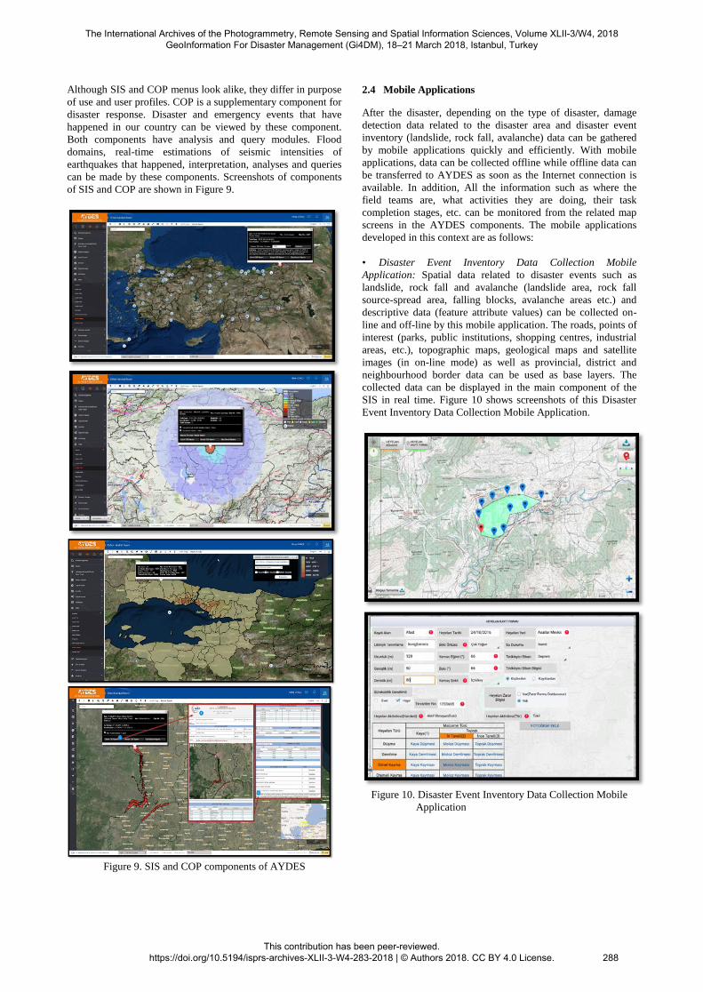
of SIS and COP are shown in Figure 9.
Figure 9. SIS and COP components of AYDES
2.4 Mobile Applications
After the disaster, depending on the type of disaster, damage
detection data related to the disaster area and disaster event
inventory (landslide, rock fall, avalanche) data can be gathered
by mobile applications quickly and efficiently. With mobile
applications, data can be collected offline while offline data can
be transferred to AYDES as soon as the Internet connection is
available. In addition, All the information such as where the
field teams are, what activities they are doing, their task
completion stages, etc. can be monitored from the related map
screens in the AYDES components. The mobile applications
developed in this context are as follows:
• Disaster Event Inventory Data Collection Mobile
Application: Spatial data related to disaster events such as
landslide, rock fall and avalanche (landslide area, rock fall
source-spread area, falling blocks, avalanche areas etc.) and
descriptive data (feature attribute values) can be collected on-
line and off-line by this mobile application. The roads, points of
interest (parks, public institutions, shopping centres, industrial
areas, etc.), topographic maps, geological maps and satellite
images (in on-line mode) as well as provincial, district and
neighbourhood border data can be used as base layers. The
collected data can be displayed in the main component of the
SIS in real time. Figure 10 shows screenshots of this Disaster
Event Inventory Data Collection Mobile Application.
Figure 10. Disaster Event Inventory Data Collection Mobile
Application
The International Archives of the Photogrammetry, Remote Sensing and Spatial Information Sciences, Volume XLII-3/W4, 2018 GeoInformation For Disaster Management (Gi4DM), 18–21 March 2018, Istanbul, Turkey
This contribution has been peer-reviewed. https://doi.org/10.5194/isprs-archives-XLII-3-W4-283-2018 | © Authors 2018. CC BY 4.0 License.
288
• Damage Assessment Mobile Application: On-line and off-
line, geo-located damage detection data can be collected using
damage detection forms in different detail. Unauthorized
transactions are prevented by interrogating the personnel
information to be assigned to the damage assessment studies
during the data entry. In practice, it can be used as a base by
taking the roads, important points (parks, public institutions,
shopping centres, industrial areas, etc.), topographic maps and
satellite images - on-line - on the mobile device memory as well
as provincial, district and neighbourhood data. The collected
data can be displayed in real-time on the relevant screens of SIS
and Recovery components. Figure 11 shows screenshots of this
Damage Assessment Mobile Application.
Figure 11. Damage Assessment Mobile Application
Other mobile applications planned to be developed under
AYDES are as follows:
• Geological Hazard Survey Reports Mobile Application:
Spatial data (survey area, landslide area, area exposed to hazard
etc.) determined in geological hazard survey reports and related
descriptive data (disaster victim list, disaster situation etc.) will
be collected on-line and off-line. The collected data can be
displayed on the relevant screens of the SIS and Recovery
components in real time.
• Resettlement Site Selection Mobile Application: This
software will allow the collection of spatial data (parcel, area,
etc. determined for site selection) and relevant descriptive data
(feature attribute values) specified in the site selection protocols
and works. The collected data can be displayed on the relevant
screens of the SIS and Recovery components in real time.
3. IMAGE PROCESSING ANA ANALYSIS SOFTWARE
TOOLS INTEGRATED TO AYDES
Before or after disasters, it’s important to access the needed
information urgently and economically for potential analysis
about the terrain besides its accuracy and reliability. Herein,
remote sensing technology provides an important data source
that can be used in disaster management. A lot and various data
and evaluations related with disaster event inventory, vulnerable
assets, hazard-risk, disaster prone areas, and damage assessment
results etc. are needed in context of disaster management and
decision support systems. For this purpose, AYDES-RS and
AYDES-CS software have been developed to use in processing
and evaluating the images provided by remote sensing
(space/aerial) technology for several disaster managements
related analyses in terms of Disaster and Emergency
Management Authority (AFAD)’s needs. Evaluation results are
integrated directly to AYDES and shared publicly by AFAD
web site.
3.1 AYDES-RS
AYDES-RS (AYDES-UZAL in Turkish) is a desktop geospatial
imagery analysis and processing that enables synthetic aperture
radar (SAR) electro-optic (EO) satellite image / aerial photo
processing and analysing. The software is designed especially
for AFAD’s special needs related with disaster management.
Technically, it is developed in Java language by using ESA’s
open source libraries. Software contains specific applications
for identifying preliminary affected area and hazard / damage
assessment caused by disasters like earthquake, flood and forest
fire. In addition to these, different applications and algorithms
also provide change detection, supervised/unsupervised
classification, object based image analysis and fabric analysis
that are integrated into the software to use for before/after
disaster related remote sensing based image analysis. The
primary aim of AYDES-RS is to offer an integrated software
solution of visualizing, processing, analysing remote sensed
data, presenting and exporting results into disaster management
and decision support systems (Figure 12, Figure 13).
3.2 AYDES-CS (Crowd-Sourcing) Platform
AYDES-CS (AYDES-KITLEKAYNAK in Turkish) is a web
based crowd - sourcing platform. Especially, while automatic
image processing algorithms produce no results or obtained
results need to be confirmed, manual assessment of post-
disaster images could be required. For this purpose, post
disaster images are divided into little pieces and tiled by the
application and then sent to previously identified users called as
crowd through the web. Users fulfil their duties by examining
the images and marking on them according to type of operation.
Same image tile can be sent more than one user. Consequently,
system examines the markings of users and produce a final
report automatically by using statistical algorithms to evaluate
the markings of users. The results might be related with
information about number, location of damaged buildings,
location of closed roads, wrecks and landslide flood prone areas
etc. can be acquirable in minutes (Figure 14).
The International Archives of the Photogrammetry, Remote Sensing and Spatial Information Sciences, Volume XLII-3/W4, 2018 GeoInformation For Disaster Management (Gi4DM), 18–21 March 2018, Istanbul, Turkey
This contribution has been peer-reviewed. https://doi.org/10.5194/isprs-archives-XLII-3-W4-283-2018 | © Authors 2018. CC BY 4.0 License.
289
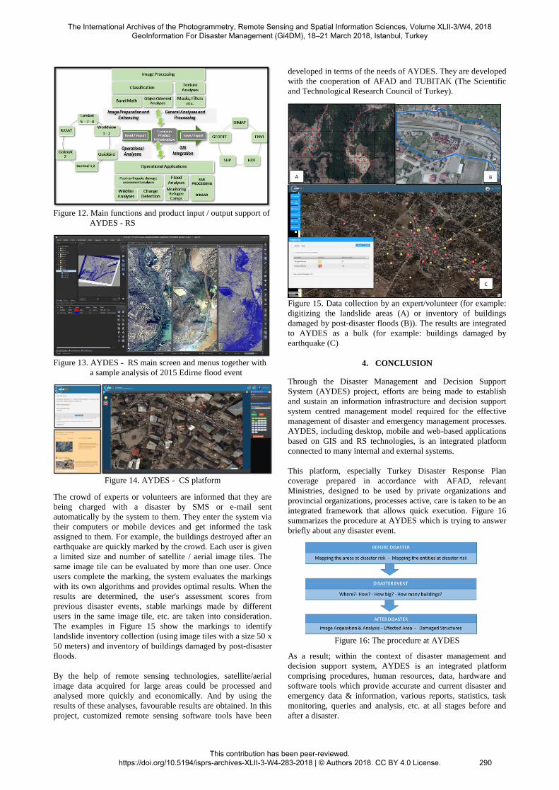
Figure 12. Main functions and product input / output support of
AYDES - RS
Figure 13. AYDES - RS main screen and menus together with
a sample analysis of 2015 Edirne flood event
Figure 14. AYDES - CS platform
The crowd of experts or volunteers are informed that they are
being charged with a disaster by SMS or e-mail sent
automatically by the system to them. They enter the system via
their computers or mobile devices and get informed the task
assigned to them. For example, the buildings destroyed after an
earthquake are quickly marked by the crowd. Each user is given
a limited size and number of satellite / aerial image tiles. The
same image tile can be evaluated by more than one user. Once
users complete the marking, the system evaluates the markings
with its own algorithms and provides optimal results. When the
results are determined, the user's assessment scores from
previous disaster events, stable markings made by different
users in the same image tile, etc. are taken into consideration.
The examples in Figure 15 show the markings to identify
landslide inventory collection (using image tiles with a size 50 x
50 meters) and inventory of buildings damaged by post-disaster
floods.
By the help of remote sensing technologies, satellite/aerial
image data acquired for large areas could be processed and
analysed more quickly and economically. And by using the
results of these analyses, favourable results are obtained. In this
project, customized remote sensing software tools have been
developed in terms of the needs of AYDES. They are developed
with the cooperation of AFAD and TUBITAK (The Scientific
and Technological Research Council of Turkey).
Figure 15. Data collection by an expert/volunteer (for example:
digitizing the landslide areas (A) or inventory of buildings
damaged by post-disaster floods (B)). The results are integrated
to AYDES as a bulk (for example: buildings damaged by
earthquake (C)
4. CONCLUSION
Through the Disaster Management and Decision Support
System (AYDES) project, efforts are being made to establish
and sustain an information infrastructure and decision support
system centred management model required for the effective
management of disaster and emergency management processes.
AYDES, including desktop, mobile and web-based applications
based on GIS and RS technologies, is an integrated platform
connected to many internal and external systems.
This platform, especially Turkey Disaster Response Plan
coverage prepared in accordance with AFAD, relevant
Ministries, designed to be used by private organizations and
provincial organizations, processes active, care is taken to be an
integrated framework that allows quick execution. Figure 16
summarizes the procedure at AYDES which is trying to answer
briefly about any disaster event.
Figure 16: The procedure at AYDES
As a result; within the context of disaster management and
decision support system, AYDES is an integrated platform
comprising procedures, human resources, data, hardware and
software tools which provide accurate and current disaster and
emergency data & information, various reports, statistics, task
monitoring, queries and analysis, etc. at all stages before and
after a disaster.
The International Archives of the Photogrammetry, Remote Sensing and Spatial Information Sciences, Volume XLII-3/W4, 2018 GeoInformation For Disaster Management (Gi4DM), 18–21 March 2018, Istanbul, Turkey
This contribution has been peer-reviewed. https://doi.org/10.5194/isprs-archives-XLII-3-W4-283-2018 | © Authors 2018. CC BY 4.0 License.
290