PostGIS Workshop Einführung in Geodatenbanken mit PostGIS · | PostGIS Einführung, FOSSGIS...
33
<[email protected]> | <[email protected]> PostGIS Einführung, FOSSGIS 2011, Heidelberg - Seite 1 PostGIS Workshop Einführung in Geodatenbanken mit PostGIS 05.04.2011, FOSSGIS 2011, Heidelberg
Transcript of PostGIS Workshop Einführung in Geodatenbanken mit PostGIS · | PostGIS Einführung, FOSSGIS...

<[email protected]> | <[email protected]> PostGIS Einführung, FOSSGIS 2011, Heidelberg - Seite 1
PostGIS WorkshopEinführung in Geodatenbanken mit PostGIS
05.04.2011, FOSSGIS 2011, Heidelberg

<[email protected]> | <[email protected]> PostGIS Einführung, FOSSGIS 2011, Heidelberg - Seite 2
Beispieldaten
● Die im Workshop verwendeten Beispieldaten sind unter der folgenden URL zu beziehen:
● http://ftp.intevation.de/users/stephan/fossgis-2011/ws/postgis/postgis-fossgis2011.tar.gz

<[email protected]> | <[email protected]> PostGIS Einführung, FOSSGIS 2011, Heidelberg - Seite 3
Über die Referenten
● Stephan Holl, – Intevation GmbH
– http://www.intevation.de/geospatial
● Harald Schwenk,– agentur geoinfo
– http://www.agentur-geoinfo.de

<[email protected]> | <[email protected]> PostGIS Einführung, FOSSGIS 2011, Heidelberg - Seite 4
PostgreSQL
● Features– AKID (Atomar, Konsistent, Isoliert, Dauerhaft)– SQL 92, Query Optimizer– Volltext-Suche– Seperation, Replikation– Hot-Backup, Write-ahead Logs / PITR– Stored Procedures– Trigger / Rules
● Freie Software: BSD
<[email protected]> | <[email protected]> PostGIS Einführung, FOSSGIS 2011, Heidelberg - Seite 5
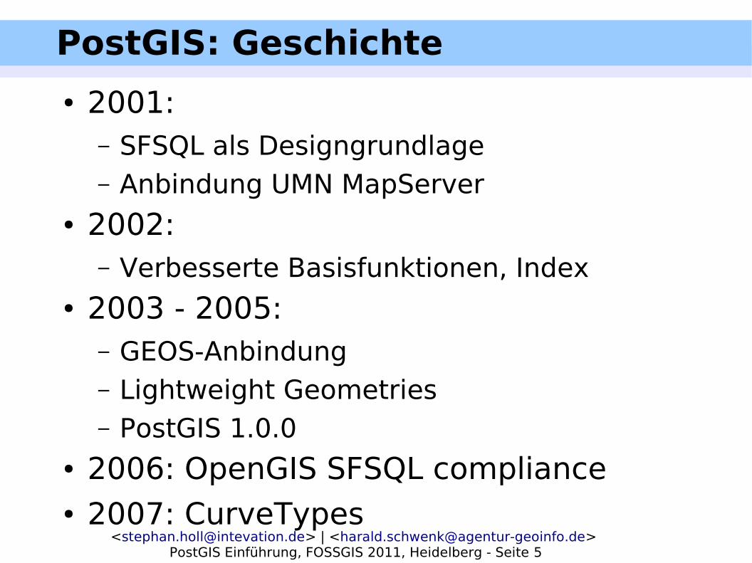
PostGIS: Geschichte
● 2001: – SFSQL als Designgrundlage– Anbindung UMN MapServer
● 2002: – Verbesserte Basisfunktionen, Index
● 2003 - 2005: – GEOS-Anbindung– Lightweight Geometries– PostGIS 1.0.0
● 2006: OpenGIS SFSQL compliance● 2007: CurveTypes

<[email protected]> | <[email protected]> PostGIS Einführung, FOSSGIS 2011, Heidelberg - Seite 6
PostGIS: Geschichte
● 2009– Performance-Optimierungen– Stabilitätsoptimierungen
● 2010– PostGIS 1.5.2, Septermber 24
● 2011– PostGIS 2.0: Raster-Support– PostGIS 2.0: 3D– Idealer Release: Juni 2011

<[email protected]> | <[email protected]> PostGIS Einführung, FOSSGIS 2011, Heidelberg - Seite 7
PostGIS Installation GNU/Linux● Distributionen liefern Pakete für
PostgreSQL● Ab PostGIS 1.1.0 vereinfachte Installation:
– Vorbedingungen:● PostgreSQL Laufzeitsystem● PostgreSQL Entwicklungspaket● PostGIS Quellen
– Installieren:● ./configure [weitere Optionen]● make● make install
● Ab PostGIS 1.5.0 Geometry-Types

<[email protected]> | <[email protected]> PostGIS Einführung, FOSSGIS 2011, Heidelberg - Seite 8
Einrichtung einer Datenbank
● createdb <datenbankname>● createlang plpgsql <datenbankname>● psql -f lwpostgis.sql <datenbankname>● psql -f spatial_ref_sys.sql
<datenbankname>
<[email protected]> | <[email protected]> PostGIS Einführung, FOSSGIS 2011, Heidelberg - Seite 9
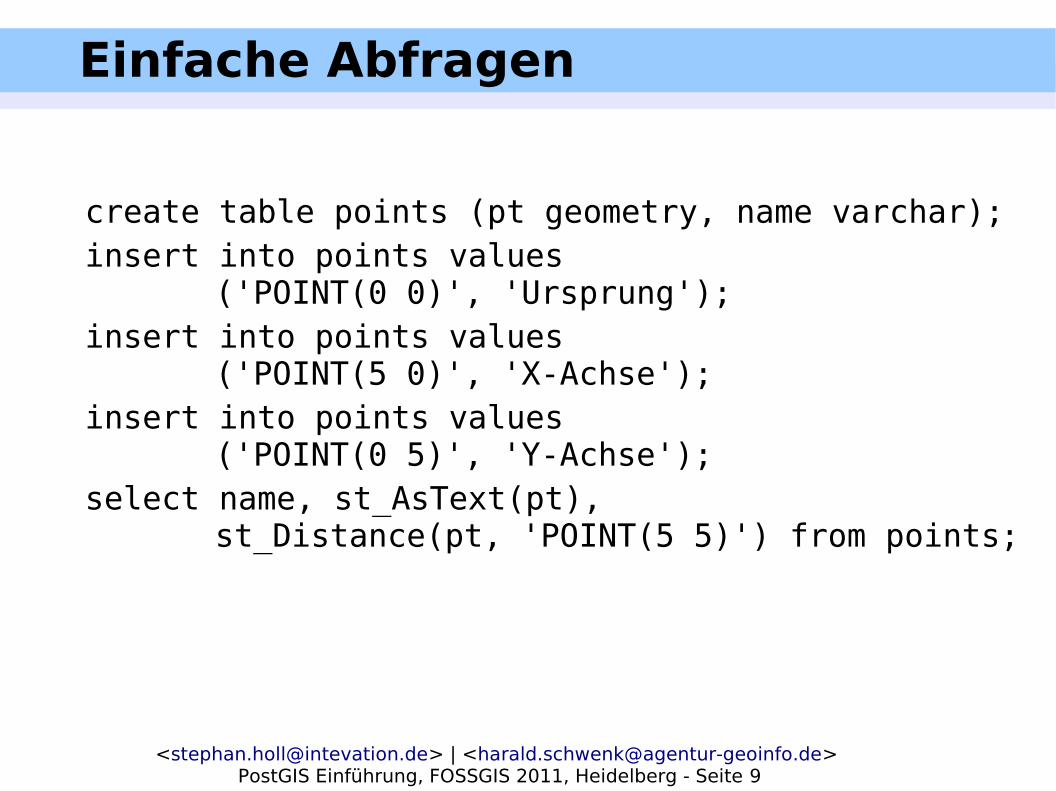
Einfache Abfragen
create table points (pt geometry, name varchar);insert into points values
('POINT(0 0)', 'Ursprung');insert into points values
('POINT(5 0)', 'X-Achse');insert into points values
('POINT(0 5)', 'Y-Achse');select name, st_AsText(pt),
st_Distance(pt, 'POINT(5 5)') from points;

<[email protected]> | <[email protected]> PostGIS Einführung, FOSSGIS 2011, Heidelberg - Seite 10
Einfache Abfragen
POINT(5 0)
POINT(0 5)
POINT(0 0)
SELECT name, st_AsText(pt), st_Distance(pt, 'POINT(5 5)') from
points;
POINT(5 5)
5
57.07

<[email protected]> | <[email protected]> PostGIS Einführung, FOSSGIS 2011, Heidelberg - Seite 11
PostGIS Geometrietypen
1. Punkte
2. Linien
3. Polygone
4. MultiPunkte
5. MultiLinien
6. MultiPolygone
7. Kollektionen
8. Kurventypen
9. 3D-Typen

<[email protected]> | <[email protected]> PostGIS Einführung, FOSSGIS 2011, Heidelberg - Seite 12
PostGIS Geometrietypen I
● POINT(5 5)● LINESTRING(0 5, 5 0);● POLYGON((0 0, 2 0, 0 2, 0 0))● MULTIPOINT((5 3), (2 5));● MULTILINESTRING ...● MULTIPOLYGON ...● GEOMETRYCOLLECTION(
POINT(...),LINESTRING(...), ...
)

<[email protected]> | <[email protected]> PostGIS Einführung, FOSSGIS 2011, Heidelberg - Seite 13
PostGIS Geometrietypen II
● CIRCULARSTRING(0 0,1 1,1 0)● COMPOUNDCURVE(CIRCULARSTRING(0
0,1 1,1 0),1 0,0 1))● CURVEPOLYGON(CIRCULARSTRING(0 0,4
0,4 4,0 4,0 0),(1 1,3 3,3 1,1 1))● MULTICURVE((0 0,5 5),CIRCULARSTRING(4
0,4 4,8 4))● MULTISURFACE(CURVEPOLYGON(CIRCULA
RSTRING()))
<[email protected]> | <[email protected]> PostGIS Einführung, FOSSGIS 2011, Heidelberg - Seite 14
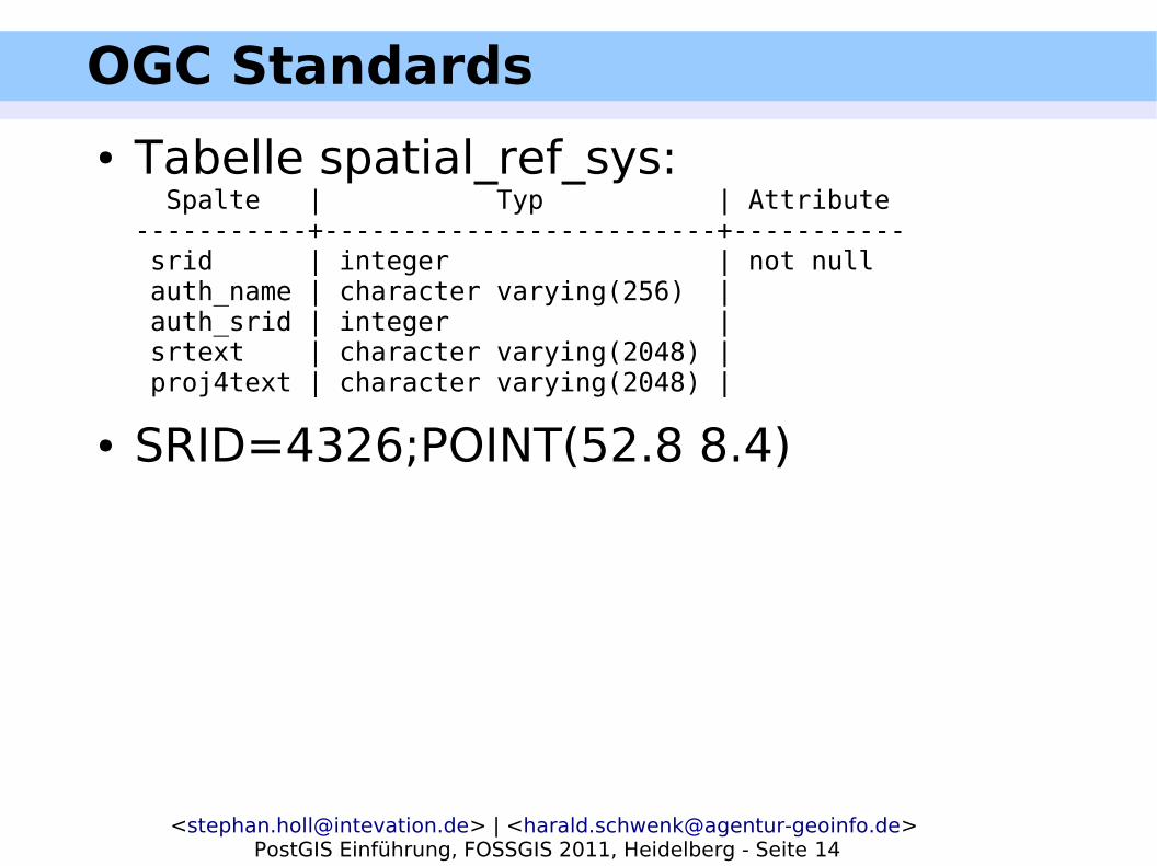
OGC Standards
● Tabelle spatial_ref_sys: Spalte | Typ | Attribute-----------+-------------------------+----------- srid | integer | not null auth_name | character varying(256) | auth_srid | integer | srtext | character varying(2048) | proj4text | character varying(2048) |
● SRID=4326;POINT(52.8 8.4)

<[email protected]> | <[email protected]> PostGIS Einführung, FOSSGIS 2011, Heidelberg - Seite 15
OGC Standards
● Tabelle geometry_columns: Spalte | Typ | Attribute-------------------+------------------------+----------- f_table_catalog | character varying(256) | not null f_table_schema | character varying(256) | not null f_table_name | character varying(256) | not null f_geometry_column | character varying(256) | not null coord_dimension | integer | not null srid | integer | not null type | character varying(30) | not null
● Funktion AddGeometryColumns:AddGeometryColumn(<schema_name>, <tabellen_name>, <spalten_name>, <srid>, <type> <dimension>)
● Ohne <schema_name> aktuelles SchemaSELECT AddGeometryColumn('roads', 'geom', 423, 'LINESTRING', 2);

<[email protected]> | <[email protected]> PostGIS Einführung, FOSSGIS 2011, Heidelberg - Seite 16
OGC Standards
● Validierung der Geometrien– Simple Feature beschränkt Varianten– PostGIS Funktion:
● isvalid(<geom>)● liefert als NOTICE Hinweise bzgl. Invalidität
– keine automatische Prüfung beim Einfügen– explizit anlegen:
● ALTER TABLE roads ADD CONSTRAINT geometrie_valide_check CHECK (isvalid(geom));

<[email protected]> | <[email protected]> PostGIS Einführung, FOSSGIS 2011, Heidelberg - Seite 17
Import von Geo-Daten
● Shp2pgsql <shapefile> <tabelle>– Optionen:
● -s: SRID● -D: Postgresql COPY (Bulk load)● -I: GiST-Index
– Ausgabe SQL-Skript– Möglichkeit einer Pipe: „| psql .....“

<[email protected]> | <[email protected]> PostGIS Einführung, FOSSGIS 2011, Heidelberg - Seite 18
Export von Geo-Daten
● Pgsql2shp <opts> <db> <tabelle>– Optionen:
● -f <Ausgabefile>● -h, -p ...●
● Beschränkungen im Zielformat beachten!

<[email protected]> | <[email protected]> PostGIS Einführung, FOSSGIS 2011, Heidelberg - Seite 19
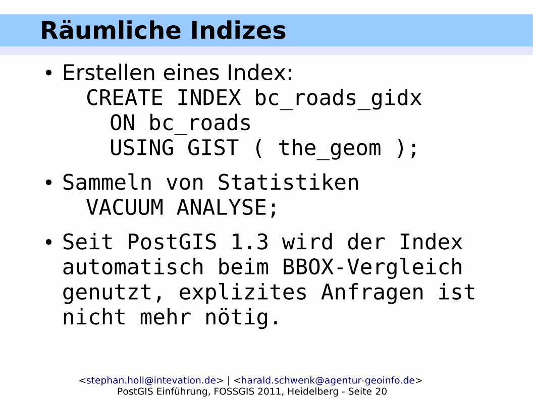
Räumliche Indizes
<[email protected]> | <[email protected]> PostGIS Einführung, FOSSGIS 2011, Heidelberg - Seite 20
Räumliche Indizes
● Erstellen eines Index:CREATE INDEX bc_roads_gidx ON bc_roads USING GIST ( the_geom );
● Sammeln von StatistikenVACUUM ANALYSE;
● Seit PostGIS 1.3 wird der Index automatisch beim BBOX-Vergleich genutzt, explizites Anfragen ist nicht mehr nötig.

<[email protected]> | <[email protected]> PostGIS Einführung, FOSSGIS 2011, Heidelberg - Seite 21
Spatial Analysis
● Gesamtlänge aller Straßen in BC in Kilometern?
SELECT sum(st_length(the_geom))/1000FROM bc_roads;

<[email protected]> | <[email protected]> PostGIS Einführung, FOSSGIS 2011, Heidelberg - Seite 22
Spatial Analysis
● Welches ist die größte Stadt, nach Fläche?
SELECT name FROM bc_municipality WHERE st_area(the_geom) = (SELECT max(st_area(the_geom))
FROM bc_municipality);● Alternative:SELECT name, st_area(the_geom) AS area FROM bc_municipality ORDER by area DESC LIMIT 1;

<[email protected]> | <[email protected]> PostGIS Einführung, FOSSGIS 2011, Heidelberg - Seite 23
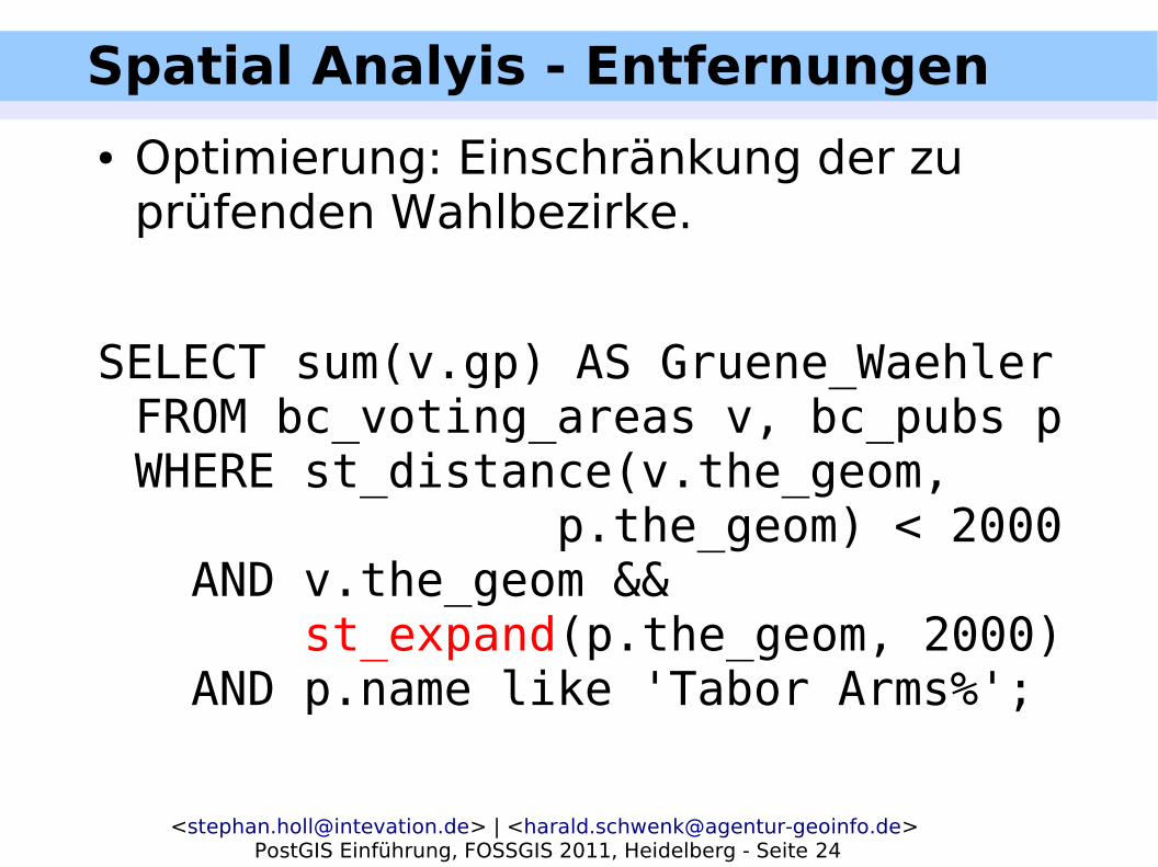
Spatial Analyis - Entfernungen
● Wieviele Wähler der Grünen Partei leben in einem höchstens 2 Kilometer vom Pub 'TABOR ARMS' entfernten Wahlbezirk?
SELECT sum(v.gp) AS Gruene_WaehlerFROM bc_voting_areas v, bc_pubs pWHERE st_distance(v.the_geom, p.the_geom) < 2000 AND p.name like 'Tabor Arms%';
<[email protected]> | <[email protected]> PostGIS Einführung, FOSSGIS 2011, Heidelberg - Seite 24
Spatial Analyis - Entfernungen
● Optimierung: Einschränkung der zu prüfenden Wahlbezirke.
SELECT sum(v.gp) AS Gruene_WaehlerFROM bc_voting_areas v, bc_pubs pWHERE st_distance(v.the_geom, p.the_geom) < 2000 AND v.the_geom && st_expand(p.the_geom, 2000) AND p.name like 'Tabor Arms%';

<[email protected]> | <[email protected]> PostGIS Einführung, FOSSGIS 2011, Heidelberg - Seite 25
Spatial Joins
● Verknüpfung zweier Tabellen anhand Beziehung zwischen Geometrien
● Alle Pubs, die näher als 250 m an einem Krankenhaus liegen:
SELECT h.name, p.nameFROM bc_hospitals h, bc_pubs pWHERE st_distance(h.the_geom,
p.the_geom) < 250;

<[email protected]> | <[email protected]> PostGIS Einführung, FOSSGIS 2011, Heidelberg - Seite 26
Spatial Joins
● Zusammenführung von Datenbeständen:– Alle Wahlkreise in 'PRINCE GEORGE':
SELECT v.idFROM bc_voting_areas v,
bc_municipality mWHERE st_intersects(v.the_geom,
m.the_geom)AND m.name = 'PRINCE GEORGE';

<[email protected]> | <[email protected]> PostGIS Einführung, FOSSGIS 2011, Heidelberg - Seite 27
Räumliche Prädikate
● Verschiedene Prädikate, um Beziehung zwischen Geometrien zu untersuchen:– st_equals(geometry, geometry)*
● Linie(0 0, 10 10), Linie(0 0, 5 5, 10 10)
– st_disjoint(geometry, geometry)*– st_intersects(geometry, geometry)*– st_touches(geometry, geometry)*
● Polygon((0 0, 1 0, 1 1, 0 0)) und● Polygon((1 1, 1 0, 2 0, 1 1))
– st_Crosses()*– st_Within()*

<[email protected]> | <[email protected]> PostGIS Einführung, FOSSGIS 2011, Heidelberg - Seite 28
Räumliche Prädikate
– st_Overlaps(geometry, geometry)*– st_Contains(geometry, geometry)*– st_Covers(geometry, geometry)*– st_CoveredBy(geometry, geometry)*– st_Relate(geometry, geometry,
intersectionPatternMatrix)*– st_Relate(geometry, geometry)*
● Dimensionally Extended 9 Intersection Model (DE-9IM)

<[email protected]> | <[email protected]> PostGIS Einführung, FOSSGIS 2011, Heidelberg - Seite 29
Verschneidungen
● Methoden zur Analyse / Erzeugung neuer Geometrien
● Prozentuale Anteile der Gemeinde Hudson's Hope an Wahlkreisen:SELECT v.id, v.region, st_Area(st_Intersection(v.the_geom, m.the_geom))/ st_Area(v.the_geom)*100 as anteilFROM bc_voting_areas v, bc_municipality mWHERE v.the_geom && m.the_geom AND m.name = 'HUDSON''S HOPE';

<[email protected]> | <[email protected]> PostGIS Einführung, FOSSGIS 2011, Heidelberg - Seite 30
Verschneidungen
● st_Intersection(geometry, geometry)*● st_Difference(geometry A, geometry B)*● st_SymDifference(geometry, geometry)*● st_Union(geometry, geometry)*● Auch als Aggregat:
– st_Union(geometry set)– st_MemUnion(geometry set)
<[email protected]> | <[email protected]> PostGIS Einführung, FOSSGIS 2011, Heidelberg - Seite 31
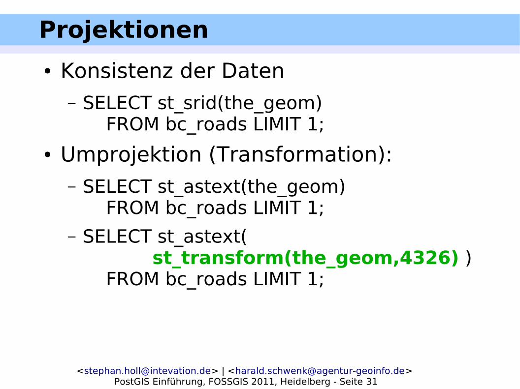
Projektionen
● Konsistenz der Daten– SELECT st_srid(the_geom)
FROM bc_roads LIMIT 1;
● Umprojektion (Transformation):– SELECT st_astext(the_geom)
FROM bc_roads LIMIT 1;– SELECT st_astext(
st_transform(the_geom,4326) )FROM bc_roads LIMIT 1;
<[email protected]> | <[email protected]> PostGIS Einführung, FOSSGIS 2011, Heidelberg - Seite 32
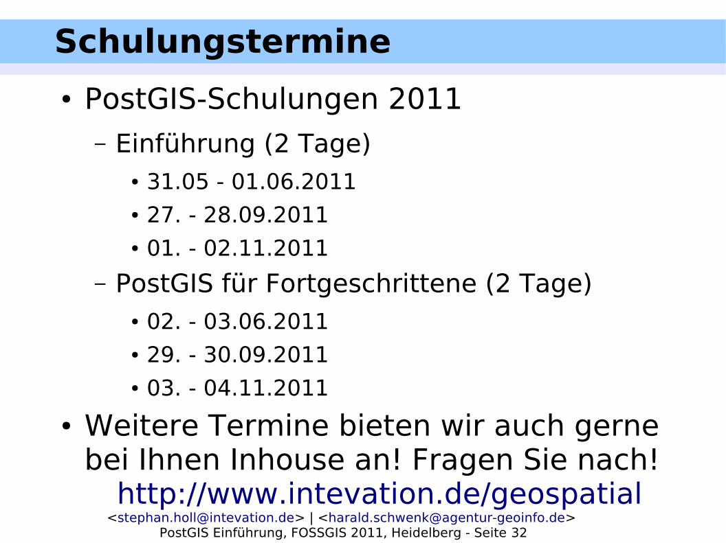
Schulungstermine
● PostGIS-Schulungen 2011– Einführung (2 Tage)
● 31.05 - 01.06.2011● 27. - 28.09.2011● 01. - 02.11.2011
– PostGIS für Fortgeschrittene (2 Tage)● 02. - 03.06.2011● 29. - 30.09.2011● 03. - 04.11.2011
● Weitere Termine bieten wir auch gerne bei Ihnen Inhouse an! Fragen Sie nach!
http://www.intevation.de/geospatial

<[email protected]> | <[email protected]> PostGIS Einführung, FOSSGIS 2011, Heidelberg - Seite 33
www.postgis.org
www.postgresql.org
Stephan Holl <[email protected]>
www.intevation.de/geospatial
Harald Schwenk <[email protected]>
www.agentur-geoinfo.de