Red Drum Essential Fish Habitat (EFH) · 82°W 82°W 83°W 83°W 84°W 84°W 85°W 85°W 86°W...
1
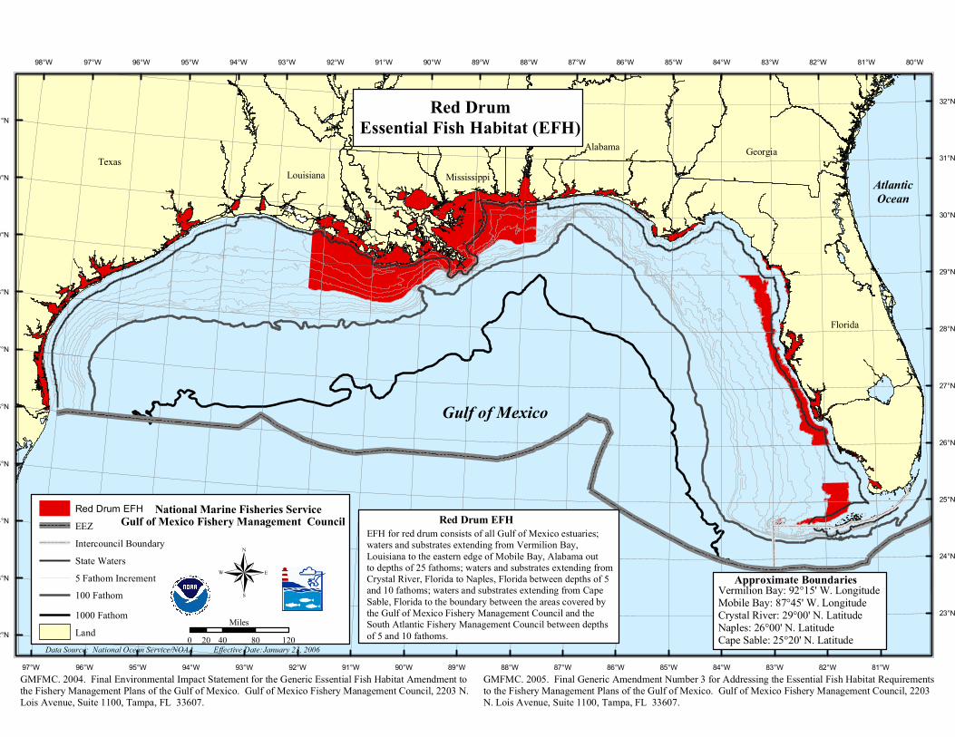
80°W 81°W 81°W 82°W 82°W 83°W 83°W 84°W 84°W 85°W 85°W 86°W 86°W 87°W 87°W 88°W 88°W 89°W 89°W 90°W 90°W 91°W 91°W 92°W 92°W 93°W 93°W 94°W 94°W 95°W 95°W 96°W 96°W 97°W 97°W 98°W 32°N 1°N 31°N 0°N 30°N 9°N 29°N 8°N 28°N 7°N 27°N 6°N 26°N 5°N 25°N 4°N 24°N 3°N 23°N 2°N Texas Florida Red Drum EFH EEZ Intercouncil Boundary State Waters 5 Fathom Increment 100 Fathom 1000 Fathom Land ® Data Source: National Ocean Service/NOAA Effective Date: Louisiana Alabama Mississippi Red Drum Essential Fish Habitat (EFH) 0 40 80 120 20 Miles National Marine Fisheries Service Gulf of Mexico Fishery Management Council January 23, 2006 Gulf of Mexico Atlantic Ocean Georgia GMFMC. 2004. Final Environmental Impact Statement for the Generic Essential Fish Habitat Amendment to the Fishery Management Plans of the Gulf of Mexico. Gulf of Mexico Fishery Management Council, 2203 N. Lois Avenue, Suite 1100, Tampa, FL 33607. GMFMC. 2005. Final Generic Amendment Number 3 for Addressing the Essential Fish Habitat Requirements to the Fishery Management Plans of the Gulf of Mexico. Gulf of Mexico Fishery Management Council, 2203 N. Lois Avenue, Suite 1100, Tampa, FL 33607. EFH for red drum consists of all Gulf of Mexico estuaries; waters and substrates extending from Vermilion Bay, Louisiana to the eastern edge of Mobile Bay, Alabama out to depths of 25 fathoms; waters and substrates extending from Crystal River, Florida to Naples, Florida between depths of 5 and 10 fathoms; waters and substrates extending from Cape Sable, Florida to the boundary between the areas covered by the Gulf of Mexico Fishery Management Council and the South Atlantic Fishery Management Council between depths of 5 and 10 fathoms. Red Drum EFH Vermilion Bay: 92°15' W. Longitude Mobile Bay: 87°45' W. Longitude Crystal River: 29°00' N. Latitude Naples: 26°00' N. Latitude Cape Sable: 25°20' N. Latitude Approximate Boundaries
Transcript of Red Drum Essential Fish Habitat (EFH) · 82°W 82°W 83°W 83°W 84°W 84°W 85°W 85°W 86°W...
80°W
81°W
81°W
82°W
82°W
83°W
83°W
84°W
84°W
85°W
85°W
86°W
86°W
87°W
87°W
88°W
88°W
89°W
89°W
90°W
90°W
91°W
91°W
92°W
92°W
93°W
93°W
94°W
94°W
95°W
95°W
96°W
96°W
97°W
97°W98°W
32°N
31°N
31°N
30°N
30°N
29°N
29°N
28°N
28°N
27°N
27°N
26°N
26°N
25°N
25°N
24°N
24°N
23°N
23°N
22°N
Texas
Florida
Red Drum EFHEEZIntercouncil BoundaryState Waters5 Fathom Increment100 Fathom1000 FathomLand
®Data Source: National Ocean Service/NOAA Effective Date:
Louisiana
Alabama
Mississippi
Red DrumEssential Fish Habitat (EFH)
0 40 80 12020Miles
National Marine Fisheries ServiceGulf of Mexico Fishery Management Council
January 23, 2006
Gulf of Mexico
AtlanticOcean
Georgia
GMFMC. 2004. Final Environmental Impact Statement for the Generic Essential Fish Habitat Amendment to the Fishery Management Plans of the Gulf of Mexico. Gulf of Mexico Fishery Management Council, 2203 N. Lois Avenue, Suite 1100, Tampa, FL 33607.
GMFMC. 2005. Final Generic Amendment Number 3 for Addressing the Essential Fish Habitat Requirements to the Fishery Management Plans of the Gulf of Mexico. Gulf of Mexico Fishery Management Council, 2203 N. Lois Avenue, Suite 1100, Tampa, FL 33607.
EFH for red drum consists of all Gulf of Mexico estuaries; waters and substrates extending from Vermilion Bay, Louisiana to the eastern edge of Mobile Bay, Alabama out to depths of 25 fathoms; waters and substrates extending fromCrystal River, Florida to Naples, Florida between depths of 5 and 10 fathoms; waters and substrates extending from Cape Sable, Florida to the boundary between the areas covered by the Gulf of Mexico Fishery Management Council and the South Atlantic Fishery Management Council between depths of 5 and 10 fathoms.
Red Drum EFH
Vermilion Bay: 92°15' W. LongitudeMobile Bay: 87°45' W. LongitudeCrystal River: 29°00' N. LatitudeNaples: 26°00' N. LatitudeCape Sable: 25°20' N. Latitude
Approximate Boundaries