Satellite-Based Real-Time Thunderstorm Nowcasting for Strategic...
12
Satellite-Based Real-Time Thunderstorm Nowcasting for Strategic Flight Planning En Route Caroline Forster ∗ DLR, Deutsches Zentrum für Luft- und Raumfahrt, 82234 Wessling, Germany Andreas Ritter † Deutsche Lufthansa AG, 60546 Frankfurt, Germany and Steffen Gemsa, ‡ Arnold Tafferner, § and Dennis Stich ¶ DLR, Deutsches Zentrum für Luft- und Raumfahrt, 82234 Wessling, Germany DOI: 10.2514/1.D0055 The added value of a satellite-based thunderstorm detection and nowcasting system with respect to flight safety and efficiency is shown by comparing onboard observations carried out by Deutsche Lufthansa AG and Deutsches Zentrum für Luft- und Raumfahrt pilots to the detection and nowcasting information in both postflight analyses and in real time. For the first time, detection and nowcasting data could be successfully uplinked into the cockpit of aircraft during flight in real time, thereby demonstrating that these data are in good agreement with the returns of the onboard radar, and furthermore provide an overview of the thunderstorm situation around the aircraft and along the aircraft’s flight track. Pilots can use the detection and nowcasting information to strategically plan their route up to 1 h ahead in time. The result is safer flight routes that avoid inadvertent flights through areas where thunderstorm- related hazards like turbulence, icing, and hail occur. In addition, the improved strategic planning enables smarter flight routes, resulting in fuel savings, reduced delays, and less deviations to alternates. I. Introduction T HUNDERSTORMS and their accompanying phenomena (like turbulence, icing, heavy precipitation, hail, and lightning) are among the most hazardous weather events for aviation. Pilots prefer to avoid thunderstorms whenever possible. En route, and especially during nighttime over the ocean, the only information source about the current weather situation is the onboard weather radar. The reliable range of the onboard radar, however, is only limited to typically 150 n miles (corresponding to about 20 min of flight time) and can only scan a limited sector in front of the aircraft. Pilots can therefore not see whether there are thunderstorms behind and sideways to the aircraft, which is critical when they have to fly avoidance maneuvers. In addition, the precipitation in strong thunder cells attenuates the onboard radar beam with the consequence that further thunder cells located behind are not detected, thus providing an incomplete picture of the thunderstorm hazard [1]. Ice crystals in the upper parts of the thunder cells (i.e., at levels where aircraft fly) are another problem, as they cause only weak radar returns, with the effect that the cells might not be recognized. Another source of uncertainty for assessing the thunderstorm threat arises from the nature of the storms, as they are quickly developing phenomena with typical lifetimes of only 30 min [2]. All these constraints make it difficult for pilots to find the safest possible route through regions with thunderstorm activity and increase the stress level in the cockpit. The results are detours leading to increased fuel burn, delays, and diversions, as well as inadvertent flights through convective cells, with all resulting in considerable costs [3–5]. For flight planning, pilots mainly rely on weather charts according to the International Civil Aviation Organization’ s (ICAO’ s) Annex 3, provided by the World Area Forecast Centers (WAFCs). Examples are significant weather charts (SIGWXs) and turbulence and icing forecasts. During flight, no updates of these charts are available, and weather information can only be provided through oral conversations with the air traffic control and other aircraft, as well as with encoded text messages like meteorological aerodrome reports, significant meteorological phenomena (SIGMETs), and terminal aerodrome forecasts (TAFs) transmitted over the Aircraft Communications Addressing and Reporting System (ACARS). Weather charts are thus outdated when used, especially during long-haul flights. In addition, weather forecast charts lack sufficient detail in space and time, and they provide only a rough estimate of the future atmospheric state. The content of these charts is generated from the output of global numerical weather prediction models that calculate the atmospheric state hours and days in advance, based on physical equations describing the thermodynamic state of the atmosphere. The initial state for such calculations is not exactly known, as observations of the atmospheric state are not available everywhere on the globe in the necessary density. Furthermore, the grid resolution of global models is only about 25 to 50 km, which is by far not enough to resolve small- scale features like convection and turbulence. Therefore, weather forecasts from these models cannot predict the exact location and time of the occurrence of thunderstorms and are not suitable to adjust flight routes. For example, Fig. 1 displays a SIGWX issued by the Washington WAFC valid for flight levels (FLs) 250–630 at 06 United Time Coordinated (UTC) on 18 August 2015 and the corresponding Meteosat infrared (IR) 10.8 μm observation valid for this time overlaid with thunderstorms as detected by a cumulonimbus tracking and monitoring system (Cb-TRAM; described in detail in Sec. II) on top. The area of the Meteosat observation corresponds to the area marked by the rectangle. Mature thunderstorms and rapidly intensifying thunderclouds are indicated by contours. The SIGWX indicates a huge area with embedded thunderstorms over the Central Atlantic between about 5 to 40°W and 5 to 15°N. Indeed, thunderstorm activity was observed west of 30°W at this time, but only a few small thunderstorms occurred between 20 and 30°W. In Received 30 September 2016; revision received 24 January 2017; accepted for publication 2 February 2017; published online 13 March 2017. Copyright © 2017 by the American Institute of Aeronautics and Astronautics, Inc. All rights reserved. All requests for copying and permission to reprint should be submitted to CCC at www.copyright.com; employ the ISSN 2380-9450 (online) to initiate your request. See also AIAA Rights and Permissions www.aiaa.org/randp. *Scientist, Institut für Physik der Atmosphäre, Oberpfaffenhofen; caroline. [email protected]. † Aircraft Captain and Head of Flight Operations Procedures and Technology Group Airlines, LH-Basis; [email protected]. ‡ Test Pilot, Flugexperimente, Oberpfaffenhofen; [email protected]. § Scientist, Institut für Physik der Atmosphäre, Oberpfaffenhofen; arnold. [email protected]. ¶ Scientist, Institut für Physik der Atmosphäre, Oberpfaffenhofen; dennis. [email protected]. 113 JOURNAL OF AIR TRANSPORTATION Vol. 24, No. 4, October 2016 Downloaded by American Institute of Aeronautics and Astronautics on April 6, 2017 | http://arc.aiaa.org | DOI: 10.2514/1.D0055
Transcript of Satellite-Based Real-Time Thunderstorm Nowcasting for Strategic...
Satellite-Based Real-Time Thunderstorm Nowcastingfor Strategic Flight Planning En Route
Caroline Forsterlowast
DLR Deutsches Zentrum fuumlr Luft- und Raumfahrt 82234 Wessling Germany
Andreas Ritterdagger
Deutsche Lufthansa AG 60546 Frankfurt Germany
and
Steffen GemsaDagger Arnold Taffernersect and Dennis Stichpara
DLR Deutsches Zentrum fuumlr Luft- und Raumfahrt 82234 Wessling Germany
DOI 1025141D0055
The added value of a satellite-based thunderstormdetection andnowcasting systemwith respect to flight safety and
efficiency is shown by comparing onboard observations carried out by Deutsche Lufthansa AG and Deutsches
Zentrum fuumlr Luft- undRaumfahrt pilots to the detection and nowcasting information in both postflight analyses and
in real time For the first time detection andnowcastingdata couldbe successfully uplinked into the cockpit of aircraft
during flight in real time therebydemonstrating that thesedata are in goodagreementwith the returns of the onboard
radar and furthermore provide an overview of the thunderstorm situation around the aircraft and along the
aircraftrsquos flight track Pilots can use the detection and nowcasting information to strategically plan their route up to
1 h ahead in time The result is safer flight routes that avoid inadvertent flights through areas where thunderstorm-
related hazards like turbulence icing and hail occur In addition the improved strategic planning enables smarter
flight routes resulting in fuel savings reduced delays and less deviations to alternates
I Introduction
T HUNDERSTORMS and their accompanying phenomena (like
turbulence icing heavy precipitation hail and lightning) are
among the most hazardous weather events for aviation Pilots prefer
to avoid thunderstorms whenever possible En route and especially
during nighttime over the ocean the only information source about
the current weather situation is the onboard weather radar The
reliable range of the onboard radar however is only limited to
typically 150 n miles (corresponding to about 20 min of flight time)
and can only scan a limited sector in front of the aircraft Pilots can
therefore not see whether there are thunderstorms behind and
sideways to the aircraft which is critical when they have to fly
avoidance maneuvers In addition the precipitation in strong
thunder cells attenuates the onboard radar beam with the
consequence that further thunder cells located behind are not
detected thus providing an incomplete picture of the thunderstorm
hazard [1] Ice crystals in the upper parts of the thunder cells (ie at
levels where aircraft fly) are another problem as they cause only
weak radar returns with the effect that the cells might not be
recognized Another source of uncertainty for assessing the
thunderstorm threat arises from the nature of the storms as they are
quickly developing phenomena with typical lifetimes of only 30 min
[2] All these constraints make it difficult for pilots to find the safest
possible route through regions with thunderstorm activity and
increase the stress level in the cockpit The results are detours
leading to increased fuel burn delays and diversions as well as
inadvertent flights through convective cells with all resulting in
considerable costs [3ndash5]
For flight planning pilots mainly rely on weather charts according
to the International Civil Aviation Organizationrsquos (ICAOrsquos) Annex 3
provided by the World Area Forecast Centers (WAFCs) Examples
are significant weather charts (SIGWXs) and turbulence and icing
forecasts During flight no updates of these charts are available and
weather information can only be provided through oral conversations
with the air traffic control and other aircraft as well as with encoded
text messages like meteorological aerodrome reports significant
meteorological phenomena (SIGMETs) and terminal aerodrome
forecasts (TAFs) transmitted over the Aircraft Communications
Addressing andReporting System (ACARS)Weather charts are thus
outdated when used especially during long-haul flights In addition
weather forecast charts lack sufficient detail in space and time and
they provide only a rough estimate of the future atmospheric state
The content of these charts is generated from the output of global
numerical weather prediction models that calculate the atmospheric
state hours and days in advance based on physical equations
describing the thermodynamic state of the atmosphere The initial
state for such calculations is not exactly known as observations of the
atmospheric state are not available everywhere on the globe in the
necessary density Furthermore the grid resolution of global models
is only about 25 to 50 kmwhich is by far not enough to resolve small-
scale features like convection and turbulence Therefore weather
forecasts from these models cannot predict the exact location and
time of the occurrence of thunderstorms and are not suitable to adjust
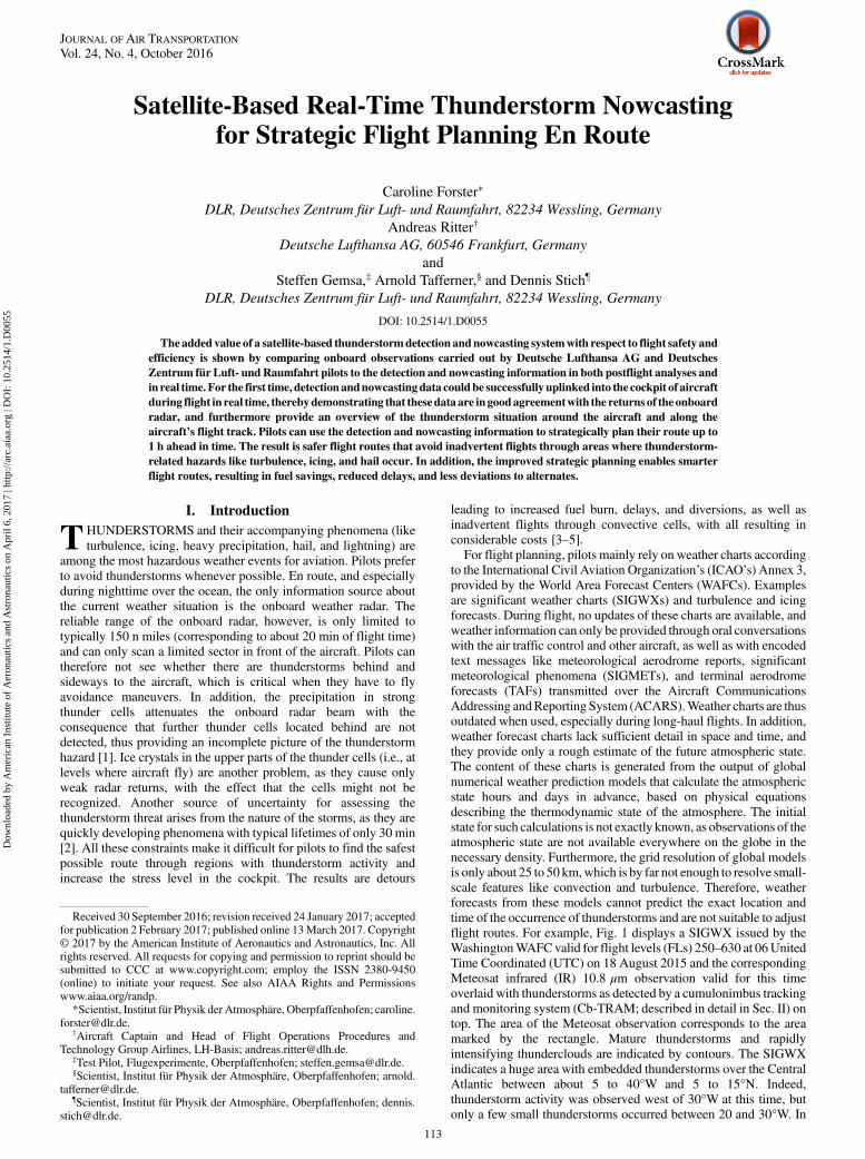
flight routes For example Fig 1 displays a SIGWX issued by the
WashingtonWAFCvalid for flight levels (FLs) 250ndash630 at 06United
Time Coordinated (UTC) on 18 August 2015 and the corresponding
Meteosat infrared (IR) 108 μm observation valid for this time
overlaid with thunderstorms as detected by a cumulonimbus tracking
and monitoring system (Cb-TRAM described in detail in Sec II) on
top The area of the Meteosat observation corresponds to the area
marked by the rectangle Mature thunderstorms and rapidly
intensifying thunderclouds are indicated by contours The SIGWX
indicates a huge area with embedded thunderstorms over the Central
Atlantic between about 5 to 40degW and 5 to 15degN Indeed
thunderstorm activity was observed west of 30degW at this time but
only a few small thunderstorms occurred between 20 and 30degW In
Received 30 September 2016 revision received 24 January 2017 acceptedfor publication 2 February 2017 published online 13March 2017 Copyrightcopy 2017 by the American Institute of Aeronautics and Astronautics Inc Allrights reserved All requests for copying and permission to reprint should besubmitted to CCC at wwwcopyrightcom employ the ISSN 2380-9450(online) to initiate your request See also AIAA Rights and Permissionswwwaiaaorgrandp
Scientist Institut fuumlr Physik der Atmosphaumlre Oberpfaffenhofen carolineforsterdlrde
daggerAircraft Captain and Head of Flight Operations Procedures andTechnology Group Airlines LH-Basis andreasritterdlhde
DaggerTest Pilot Flugexperimente Oberpfaffenhofen steffengemsadlrdesectScientist Institut fuumlr Physik der Atmosphaumlre Oberpfaffenhofen arnold
taffernerdlrdeparaScientist Institut fuumlr Physik der Atmosphaumlre Oberpfaffenhofen dennis
stichdlrde
113
JOURNAL OF AIR TRANSPORTATIONVol 24 No 4 October 2016
Dow
nloa
ded
by A
mer
ican
Ins
titut
e of
Aer
onau
tics
and
Ast
rona
utic
s on
Apr
il 6
201
7 | h
ttp
arc
aiaa
org
| D
OI
10
2514
1D
0055
particular the SIGWX could not depict the location of the thundercells and the gaps in betweenMany efforts have been undertaken in order to improve
thunderstorm forecasts for aviation Expert systems have beendeveloped that combinemodel forecastswith satellite radar lightningand further ground-based observations in order to get a more completepicture of the current weather situation thereby improving its forecastfor the next hours Examples are the Integrated Terminal WeatherSystem [6] an auto-nowcast system [7] and the Weather ForecastUser-Oriented System Including Object Nowcasting (WXFUSION)[89] Most of these systems provide thunderstorm detectionsdeterministic forecasts of thunderstorm cells up to the first hour and aprobability or likelihood of thunderstorm occurrence beyondDeterministic thunderstorm forecasts are based on technologies thatextrapolate observations from (for example) radar or satellites up to 1 hinto the future (called nowcasting) Several radar-based nowcastingsystems have been developed [10ndash13] While these are limited toapplications over land where ground weather radar measurements areavailable satellite-based systems cover much larger areas and can beapplied over the ocean and regions where other observations are rareA variety of algorithms have been developed in the past with somefocusing on the convection initiation stage [14ndash17] andothers focusingon the detection tracking and nowcasting of mature thunderstorms[18ndash24]Satellite-based detection and nowcasting systems are very useful
for the situational awareness of hazards for pilots en route becausethey provide a precise overview on the location of currently activethunderstorm cells and their movement in the near future in regionswhere other observational data are rare (eg over the oceans and
Africa) In particular the information provided extends the onboardradar range If this information was uplinked into the cockpit ofaircraft in real time pilots could strategically plan and eventuallyadjust their flight route in time instead of searching for gaps betweenthe thunder cells The benefits are increased flight safety increasedcomfort for passengers and crew and less detours and diversionsresulting in fuel savings and reduced costs The added value of real-time weather information in the cockpit has already been shown inseveral studies (eg [13425]) and projects like FLYSAFE [26]Weather Technology in the Cockpit (WTIC) [27] and eFlightOps[28] These studies highlighted the potential for cost savings andflight safety in particular the advantage of the overview provided bya graphical display instead of a text message and the commonsituational awareness if the information is shared among pilots anddispatchersAlthough the technical feasibility of the groundndashair datalink of
graphical weather hazard information has already been demonstratedin the past (eg [3]) the display of this information in primary flightdisplays is still within the domain of research and developmentMany hurdles related to institutional issues like regulationcertification and quality management have to be overcome beforeground-based weather information can be part of avionic systemsHowever the increasing use of electronic flight bags (EFBs) andiPads in the cockpit offers newopportunities because they are not partof the avionic systems Originally EFBs and iPads were introducedto replace the extensive paperwork (manuals flight charts etc) in thecockpit but in combinationwith Internet protocols (IPs) andmodernsatellite communication links via (for example) Iridium andInmarsat they can also be used to display up-to-the-minute
Fig 1 SIGWX overlaid with corresponding Meteosat observation including Cb-TRAM contours
114 FORSTER ETAL
Dow
nloa
ded
by A
mer
ican
Ins
titut
e of
Aer
onau
tics
and
Ast
rona
utic
s on
Apr
il 6
201
7 | h
ttp
arc
aiaa
org
| D
OI
10
2514
1D
0055
information uplinked from the groundNow activities are going on toequip more aircraft cockpits with satellite-connected EFBs Next toflight-relevant data like actual position reporting flight level andspeed changes and notices to airmen (NOTAMs) the connectivity ofthe EFBs shall be used to also send real-timeweather information andgraphically display it to the pilots Lufthansa is one of the firstcommercial airlines in terms of developing the necessary airside andgroundside data transmission infrastructures required for establish-ing a datalink system into the cockpit This system was used totransmit Cb-TRAM data to an EFB in real time as describedin Sec IVIn this paper we focus on the merit of thunderstorm information
from Cb-TRAM with regard to flight safety and fuel savings and weexplain in detail how Cb-TRAM data can help to optimize the flightrouting in combination with the onboard radar We present postflightanalyses aswell as observations fromone researchandone commercialflight where Cb-TRAM data have been uplinked in real time forthe first time by using modern satellite communication technologiesThe paper is structured as follows Sec II provides a description ofCb-TRAM Sec III introduces some postflight validations ofCb-TRAM in close cooperation with Lufthansa pilots in Sec IV thereal-time in-flight datalink tests are presented followed by discussionand conclusions in Secs Vand VI respectively
II Cb-TRAM
One of the goals in several research projects at the DeutschesZentrum fuumlr Luft- und Raumfahrt (DLR) was the development ofthunderstorm information systems specifically tailored to the needsof users in the aviation sector One of them is Cb-TRAM Duringthunderstorm situations aviation stakeholders have to make quickand appropriate decisions in order to mitigate the thunderstormrsquosimpact on the operational procedures and to guarantee flight safety ie they need information that is easy to interpret at a glance Inaddition because satellite communication techniques still offer onlylimited bandwidths (eg Iridium on the order of a few bits persecond Inmarsat on the order of 05 Mbits∕s) and the costs for theup- and downlink of data packages are high the thunderstorminformation to be uplinked has to be reduced to small data amountsand packed in formats that are highly compressible To meet all theserequirements thunderstorms are rendered as simple objects in Cb-TRAM representing hazardous areas for aircraft Analyses andnowcasts of thunderstorm objects as well as specific attributes likemoving speed moving direction top height and trend are output in astandard extensible markup language (XML) format [29] which isextendable compatible with any displays and systems allows fastselectable reading and can be compressed to small data amounts of afew kilobytes enabling inexpensive uplink to the flight deckCb-TRAM uses spectral channel data from the geostationary
meteorological satellite Meteosat-10 (Fig 2) which covers Europethe Middle East Africa the South Atlantic parts of the NorthAtlantic and parts of South America and it provides data for thisviewing area with an update rate of 15 min [2324] Two infrared(IR 108 μm and IR 120 μm) onewater vapor (WV62 μm) and thehigh-resolution visible (HRV) channel are combined in order toidentify three different stages of thunderstorms as illustrated in Fig 3for a thunderstorm situation overGermany and neighboring countrieson 5 July 2016 at 1645 UTC clouds that potentially grow to athunderstorm (development stage 1 yellow contours) rapidlyvertical developing clouds (development stage 2 orange contours)and mature stage (development stage 3 red contours) The trackingand nowcasting up to 1 h of the thunderclouds (dashed contours inFig 3) are based on a sophisticated image-matching technique thatdoes not only account for the overall movement of the clouds but alsofor their individual development including growth and decay Notethat Cb-TRAM does not simply encompass the whole anvil area butthe most active parts of the thunderclouds ie those areas whereturbulence and lightning can be expected The accuracy of Cb-TRAM has been verified by a comparison with lightning data overEurope and South Africa for several months [24] The algorithmprovides robust results for these very different climate regions with a
probability of detection up to 95 for the analysis and up to 70 forthe 1 h nowcastFigure 4 emphasizes the value of the Cb-TRAM information for
pilots It shows a Meteosat-10 IR 108 μm image with Cb-TRAMdetections and nowcasts over the equatorial Atlantic displayed as inFig 3 Let us assume that an aircraft is on theway on its planned flightroute along thewhite dashed line during nighttime and has just passedwaypoint VUKIR The range of the onboard radar is indicated by theoutlined yellow sector In this case the pilot can most probably seethe thunder cell located in the front left of the aircraft at about05degS∕295degW and hemay also recognize the rapidly developing cellclose to waypoint DIGOR on his onboard radar under favorablecircumstances However he does not yet see the thunderstormclusters coming up between 2 and 3degN If he had Cb-TRAMdisplayed in the cockpit as additional information on an EFB at thistime he could plan an alternate route also taking into account themoving direction and the development of these cells For instance hecould divert to the flight route along BODAK-RAKUD further to thewest and ask for clearance of this alternate route without timepressure instead of following his original route until the thunder cellsappear on the onboard radar and not until then start searching for gapsbetween the thunder cells
III Validation of Cb-TRAM with Postflight Analyses
In close cooperation with Lufthansa Cb-TRAM detections andnowcasts of thunderstorms have beenvalidated in postflight analyses
Fig 2 Meteosat coverage area Source EUMETSAT
Fig 3 Meteosat-10 HRV observation with Cb-TRAM detections andnowcasts
FORSTER ETAL 115
Dow
nloa
ded
by A
mer
ican
Ins
titut
e of
Aer
onau
tics
and
Ast
rona
utic
s on
Apr
il 6
201
7 | h
ttp
arc
aiaa
org
| D
OI
10
2514
1D
0055
During flights over the South Atlantic and over the Mediterranean
area Lufthansa pilots documented the thunderstorm activity on their
flight route with photographs of the thunderstorms onboard radar
images and notes eg on position and time of occurrence of the
thunderstorms The documentationwas then compared toCb-TRAM
results and the accuracy and added value ofCb-TRAMwas assessed
Two of these validations are presented next
The first onewas performed for a flight from Frankfurt (Germany)
to Rio de Janeiro (Brazil) during the night from 14 to
15 February 2014 The SIGWX from the briefing package at
0600 UTC on 15 February 2014 (Fig 5) warned of isolated
embedded thunderstorms (ISOL EMBD CB) to the west and
occasional thunderstorms (OCNL CB) to the east of the planned
flight route (black line) both up to FL450 in the region between 4degN
and 4degS of the equator This area was crossed between 545 and
628 UTC exactly at the applicability of this chart
At 545UTCwhen the aircraft was at 5degN 35degWat FL340 the first
thunderstormswere visible on the onboard radar (Fig 6a) about 200 n
miles ahead of the aircraft and located directly on the planned flight
route toward way point JOBER at 095degS∕3705degW (dashed line in
Fig 6a) According to the onboard radar the gap to the west seemed
larger therefore the pilots asked for permission to deviate 30 n miles
to the west At this time the onboard radar was the only information
available to the pilots No SIGMET warning was issued for flight
information region (FIR) ldquoAtlanticordquo where they were currently
flying through There was a SIGMET for the FIR ldquoReciferdquo further to
the south but this was misleading because the coordinates of the
SIGMET warning region closely followed the boundaries of FIR
Recife although thunderstorms existed in the neighboring FIR
Atlantico too When the aircraft was as close as 60 n miles to the
thunderstorms the onboard radar image confirmed that the decision
to deviate to the west was correct At 0554 UTC at a distance of
Fig 4 Meteosat-10 IR 108 μm image with Cb-TRAM contours as well as flight routes and waypoints
Fig 5 SIGWX flight route and waypoints (triangles) The unmarked triangle just south of the equator is waypoint JOBER
116 FORSTER ETAL
Dow
nloa
ded
by A
mer
ican
Ins
titut
e of
Aer
onau
tics
and
Ast
rona
utic
s on
Apr
il 6
201
7 | h
ttp
arc
aiaa
org
| D
OI
10
2514
1D
0055
about 30 n miles from the thunderstorm cells the onboard radar
returns got weaker because the radar beam still tilted at 175 deg
down started to sweep over the thunderstorm tops The pilots
observed cloud tops at altitudes slightly lower than the cruising height
of the aircraft (FL340)Figure 6b shows the Cb-TRAMpostanalysis at 0552 UTC which
is the closest corresponding time to the onboard radar image in
Fig 6a The overview of the situation shows a mature thunderstorm
on the original flight route at 3degN 355degW which was forecast to
propagate in a northeasterly direction within the next hour and
rapidly developing cells located at 3degN 365degWand 25degN 35degW All
these cells were confirmed by the onboard radar which reflected the
situation from a NorthndashSouth perspective (Fig 6a) The leftmost line
indicates the deviation that was flownwith aircraft positions at 0545
0554 and 0601 UTCLooking at the Cb-TRAM image that was valid about 40 min
before the thunderstorms appeared on the onboard radar it can be
seen that the mature thunderstorm at 3degN 355degW was already there
and was forecast to move in a northeasterly direction within the next
hour (Fig 7) If this information would have been available during
flight the pilots would have been aware of the existence of the
thunderstorm well in advance Moreover the Cb-TRAM images
would have shown much earlier than the onboard radar that a
deviation to thewest was the right choice given the indicatedmovingspeed and moving direction of the mature thunder cell and the rapiddevelopments to the eastAbout half an hour later during this flight between 0615 and
0630UTC further but smaller thunder cells appeared on the onboardradar especially west of the waypoint JOBER (Fig 8a) The pilotsestimated the cloud tops to be below FL340 Indeed these cells weredetected by Cb-TRAM as not yet mature but rapidly intensifyingcells (Fig 8b) and they could finally be confirmed by a photographout of the cockpit (Fig 9) the cells were growing but had not yetdeveloped the anvil which is a typical signature of a maturethunderstormThe second validation was done for a Lufthansa flight from Accra
(Ghana Africa) to Frankfurt (Germany) during the night from 24 to25 July 2014 Over the Mediterranean Sea thunder cells appearedin the onboard radar and were visible by a view out of thewindow (Fig 10)The onboard radar image at 0117 UTC about 2 min before the
photograph in Fig 10was taken shows several thunder cells about 30to 40 n miles ahead of the aircraft (Fig 11a) All these cells were alsodetected by Cb-TRAM partly asmature storms and partly as rapidlydeveloping cells (Fig 11b) Even the cell 10 n miles at the right-handside of the aircraft (Fig 11a) was identified as a rapidly developingthunderstorm (Cb-TRAM contour at 384degN 55degE in Fig 11b) Aninspection of the Cb-TRAM analyses and nowcasts 1 h before (notshown) revealed that the thunderstorms seen at 0117 UTC rapidlydeveloped within a strong westerly flow and propagated eastwardwith a moving speed of about 15 m∕s Also in this example Cb-TRAMwould have raised the pilotsrsquo awareness of the thunderstormstheir development and their moving direction and speed in advanceif the Cb-TRAM data would have been available in the cockpit
IV Real-Time Uplink of Cb-TRAM into the Cockpit
For the uplink into the cockpit Cb-TRAM provides analyses andnowcasts in real time based on the latest available Meteosatobservation Thereby the typical latency between the Meteosatobservation of one region (the time of the scan of that region) and theavailability of the Cb-TRAM output for that region is typically 7 minwith a variability of ∕ minus 1min depending on the number ofthunderstorms occurring in the area Both theXMLdata and graphicswere provided on a ftphttp site at DLR Users could either pick upand transfer the data to their own systems and displays or if theypreferred directly view the graphics in a Web browser
Fig 6 Representations of a) photograph of the onboard radar displayand b) Meteosat-10 IR 108 μm with Cb-TRAM contours and flightroutes
Fig 7 Same as Fig 6b but for 0507 UTC observation time
FORSTER ETAL 117
Dow
nloa
ded
by A
mer
ican
Ins
titut
e of
Aer
onau
tics
and
Ast
rona
utic
s on
Apr
il 6
201
7 | h
ttp
arc
aiaa
org
| D
OI
10
2514
1D
0055
The very first uplink test with Cb-TRAM was successfullyperformed during a research flight of the DLR High-Altitude andLong-Range Research Aircraft (referred to as HALO) which is amodified Gulfstream G-VSP (G550) aircraft Although HALO is
equippedwith an Iridiumdatalink this link could not be used becausethere was no device connected that could display the Cb-TRAMXML or graphic data However the gimballed limb observer forradiance imaging of the atmosphere measurement instrument(GLORIA) was on board in the cabin and its own Iridium datalinkwas used to control the instrument from the ground In the aircraft alaptop was coupled to this datalink providing the opportunity toconnect to the Internet and display the Cb-TRAM real-time graphicswith a Web browser This opportunity was used on the way throughthe Intertropical Convergence Zone (ITCZ) from the Cape VerdeIslands to Cape Town on 11 September 2012 Shortly after takeoffwhen HALO had just passed waypoint RAMOL and headed towardwaypoint MOGSA at 0807 UTC the pilots saw a thunderstorm inthe front right of the onboard radar image in about a 250 n miledistance (Fig 12) The thunderstorm was only partly detected by theonboard radar due to its limited scanning sector in front of the aircraftThe captain of the aircraft then went into the cabin and started todownload the latest Cb-TRAM real-time image at about 41000 ftaltitude by using the GLORIA Iridium link Due to the limitedbandwidth of the Iridium connection the image with a size of about200 kB (satellite image overlaid with Cb-TRAM contours) tookabout 4 min to be uplinked at 0815 UTC It showed the Meteosat IR108 μm satellite image at 0745 UTC with a big thunderstormsystem detected by Cb-TRAM between 10 to 20degN and 22 to 24degWwhich was predicted to grow within the next hour (Fig 13)Compared to the onboard radar image (Fig 12) Cb-TRAM gave thebigger picture thereby not only showing the whole extent of thethunderstorm but also the development of this storm within the nexthour and that the planned flight route was not affected bythunderstorms beyond the waypoints MOGSA and TITORFurther successful datalink tests have been performed in
cooperation with Lufthansa SITA and Lufthansa Systems inFall 2012 and Spring 2013within the Lufthansa GroundAir DatalinkCommunication project The goal of this project was the deploymentof a new eEnabling communication infrastructure for LH by usingmedia independent aircraft messaging which is a communicationstandard allowing the exchange of binary data over ACARS and IPcommunication links Three different links were implemented totransmit data from a LH ground server to EFBs on board an aircraft1) cell-phone IP for 3G∕3G-equipped LH Cityline aircraft whilethey are on the ground 2) FlyNet IP for FlyNet-equippedLHaircraftwhile they are flying above 10000 ft (FlyNet is the satellitecommunication link originally developed for cabin entertainment inLufthansa aircraft) and 3) ACARS when feasible (dependent onbandwidth requirements)First Cb-TRAM images were picked up in real time by LH from
the DLR ftphttp site transmitted to the LH ground server and thensent to the EFB via the 3G cell-phone IP linkwhile the aircraft was onthe ground (Fig 14) Next Cb-TRAMXMLdatawere integrated and
Fig 8 Same as Fig 6 but for 0616 UTC in a) and 0622 UTC in b)
Fig 9 Photograph out of the window to the west about 20 n miles northof JOBER at 0627 UTC
Fig 10 Photograph out of the window to the northwest at 3840degN 525degE on 25 July 2014 at 0119 UTC
118 FORSTER ETAL
Dow
nloa
ded
by A
mer
ican
Ins
titut
e of
Aer
onau
tics
and
Ast
rona
utic
s on
Apr
il 6
201
7 | h
ttp
arc
aiaa
org
| D
OI
10
2514
1D
0055
displayed in the LH eRouteManual (eRM) where they could be
overlaid with other flight-relevant data and maps and then uplinked
in flight via FlyNet IP or ACARS Figure 15 shows an example
screenshot The darkest areas represent Cb-TRAM-detected regions
that were currently affected by thunderstorms the lightest areas
represent regions that were predicted to be affected by thunderstorms
within the next hour and arrows indicate themoving direction withinthe next hourFor the uplink only those Cb-TRAM thunder cells were extracted
that were relevant for the respective flight and the resulting
information was highly compressed For instance 54 thunder cells
with a total of 451 coordinate points describing their contours could
be reduced to about 1 kB and easily sent to the aircraft evenvia ACARSIn February 2013 the first in-flight real-time uplink tests with Cb-
TRAMXMLdatawere performed via FlyNet over the SouthAtlantic
in a series of four flights Again Cb-TRAM XML data were picked
up in real time byLH from theDLR ftphttp site and transmitted to the
LH ground server On request by the pilot the latest data were thenuplinked via FlyNet and displayed in the eRM on the EFB During
one flight from Rio de Janeiro to Frankfurt on 4 February 2013 thewhole uplink chain could successfully be demonstrated and thevalue of the Cb-TRAM information for flight safety and fuel savingscould be shown According to the SIGWXs (Fig 16) thunderstorm
activity was expected in the area of the Cape Verde Islands Aroundthe equator in the ITCZ however thunderstorms were predictedmainly west of the flight route The captain calculated that at around03 UTC they would encounter the margins of the large cloud system
moving into their flight path from the west which could be easilycircumnavigated with a minor deviation and that they would only befacing thunderstorms much later over the Cape Verde IslandsTherefore he decided to take his mandatory rest during the first part
of the flight and leave the navigation to his two copilots until theyapproached the Cape Verde Islands where he intended to uplink andvalidate the Cb-TRAM data By the time the aircraft approached theITCZ at around 03 UTC the onboard radar showed that they were
heading straight into an extensive area of thunderstorms with intensethunder cells Having in mind the SIGWX forecast with the
Fig 11 Same as Fig 6 but for 25 July 2014 at a) 0117 UTC and b) 0115 UTC
Fig 12 Photograph of the onboard radar display in HALO on11 September 2012 at 0807 UTC
Fig 13 Photograph of the GLORIA laptop screen on board of the DLRHALO on 12 September 2012 at 0815 UTC
FORSTER ETAL 119
Dow
nloa
ded
by A
mer
ican
Ins
titut
e of
Aer
onau
tics
and
Ast
rona
utic
s on
Apr
il 6
201
7 | h
ttp
arc
aiaa
org
| D
OI
10
2514
1D
0055
thunderstorm activity predicted mainly to thewest of the flight route
the copilots asked the air traffic control for a deviation to the east for
which they got clearance at 0321UTCWhen the captain waswoken
up by his copilots as planned at 0335 UTC the copilots had already
deviated from the original flight path to 120 deg which had taken
them completely off their original course of 90 deg and in the
direction of South Africa (Fig 17) The captain quickly uplinked
the latest Cb-TRAM data to the Lufthansa eRM at 0355 UTC and
was provided with a much broader picture 1 min later (Fig 18) At
this time the aircraft was at the position indicated by the mouse
cursor in Fig 18 The overview provided by Cb-TRAM showed
that earlier on they had missed a gap between the thunder cells
(flight route along waypoints ORAROndashTASIL) that would have
allowed them to stay much closer to their original course The
Fig 14 Photograph of Lufthansa EFB with a Cb-TRAM image on board of a Lufthansa A340 aircraft on 1 October 2012
Fig 15 Screenshot of the LH eRM with Cb-TRAM data displayed on an aeronautical chart (nautical miles shown as ldquoNMrdquo in figures)
120 FORSTER ETAL
Dow
nloa
ded
by A
mer
ican
Ins
titut
e of
Aer
onau
tics
and
Ast
rona
utic
s on
Apr
il 6
201
7 | h
ttp
arc
aiaa
org
| D
OI
10
2514
1D
0055
onboard radar had not detected this gap due to its limited rangeHowever the captain also saw from the Cb-TRAM overview thatthere was another gap coming up that was also not observed by theonboard radar He decided to take this opportunity planned thesafest route according to Cb-TRAM and flew it tactically bylooking at the onboard radar ie he verified with the onboardradar that the route was as safe as Cb-TRAM had predicted itIndeed the gap between the thunder cells could be confirmed withthe onboard radar when they turned the aircraft by 90 deg to theleft The area of thunderstorms could safely be passed and theflight to Frankfurt could be continuedIn total the aircraft flew a deviation of 300 n miles (Fig 19 line
with triangles) and the circumnavigation of the thunderstormsreduced the fuel reserve by 30 tons If the aircraft had continued thecourse of 120 deg just a few more minutes a stopover in Paris wouldhave been necessary for refueling In a postanalysis the captaincalculated that they could have saved more than 2 tons of fuel if theyhad uploaded Cb-TRAM a few minutes earlier and had seen andflown the first gap which was closer to their original course (flightroute along waypoints ORAROndashTASIL)
V Discussion
The cases presented in this study demonstrate that Cb-TRAM is avaluable tool to provide pilots an overview of the currentthunderstorm situation and its development in the next hour beyondthe onboard radar range However Cb-TRAM can never replace theuse of onboard radars There is always a latency of about 7 minbetween the observation by satellite and the Cb-TRAM dataavailability and display in the cockpit which is partly due to thetransmission of the satellite data down to Earth to the Cb-TRAMoperation center (about 5 min) and the Cb-TRAM processing time(about 2 min) Because thunderstorms are quickly developingphenomena the details of the thunderstorm situation might changewithin this period In contrast the onboard weather radar reflects thecurrent observation immediately in front of the aircraft Thereforethe primary information for tactical maneuvers (ie seconds up tominutes ahead)must still be the onboard radar whereas Cb-TRAM issuitable for the strategic planning of the flight route 10ndash60min aheadThe Lufthansa flight described in Sec IV is an example of how pilotscan use the combined information from the onboard radar and Cb-TRAM Cb-TRAM provides the overview of the situation thus itcan act as a pathfinder which is then verified with the onboard radarfor the tactical flight maneuversThe information provided by Cb-TRAM is not only useful when
uplinked into the cockpit but also when available at the ground Forinstance flight dispatchers flight followers and air traffic controllerscan use the Cb-TRAM information inweather displays on the groundto advise pilots en route via ACARS or voice regarding appropriateavoidance maneuvers if the planned flight route crosses areas withthunderstorm activity Moreover if Cb-TRAM information wasavailable to all aviation stakeholders on the ground and in the air thecommon situational awareness of thunderstorm impacts in the nearfuture could facilitate the discussion about mitigation strategies Thiscan potentially reduce the workload of the decision makers andsupport collaborative decision making (CDM) in the manner of theSESAR (Europe) NextGen (United States) and CARATS (Japan)programsNote that the onboard radar observes other aspects of a thunder cell
than Cb-TRAM Cb-TRAM detects the thunderclouds as seen fromspace ie it marks areaswith towering clouds that quickly growwithtime and have a texture exceeding a critical threshold In these areasheavy turbulence icing lightning and heavy rain (or even hail) canbe expected In contrast the onboard radar detects only theprecipitation of the thunderclouds For this reason the most intenseprecipitation cores (as indicated by red colors in the onboard radardisplay in Fig 17) indicating heavy rain and hail cover much smallerareas than theCb-TRAMobjects which also include other hazardousfeatures Thus Cb-TRAM helps the pilot to not only keep a safe
Fig 16 SIGWXs valid on 4 February 2013 at a) 00 UTC and b) 06 UTC
Fig 17 Photograph of the onboard radar display on 4 February 2013 at0354 UTC
FORSTER ETAL 121
Dow
nloa
ded
by A
mer
ican
Ins
titut
e of
Aer
onau
tics
and
Ast
rona
utic
s on
Apr
il 6
201
7 | h
ttp
arc
aiaa
org
| D
OI
10
2514
1D
0055
distance to the heavy precipitation cores but also to the other hazards
related to a thunderstorm
The present study presents only a few cases illuminating the
potential the accuracy and the merit of Cb-TRAM Fortunately the
Lufthansa flight fromRio de Janeiro to Frankfurt described in Sec IV
was equipped with an in-service aircraft for a global observing
system (IAGOS) measurement instrument that measured different
meteorological parameters like temperature water vapor and ice
particle number concentrations These measurements provided
further evidence that the flown route was safe with regard tothunderstorm-related hazards The IAGOS database covers a largenumber of flights and offers the opportunity for an ongoing study tosystematically proof the validity of Cb-TRAM [30]
VI Conclusions
Cb-TRAM is an algorithm for the detection tracking andforecasting of thunderstorms up to 1 h (called nowcasting) based on
Fig 18 Photograph of the EFB with Cb-TRAM data at 0330 UTC and the onboard radar display at 0356 UTC
Fig 19 Photograph of the EFB with Cb-TRAM data in the eRM from 4 February 2013 at 0415 UTC
122 FORSTER ETAL
Dow
nloa
ded
by A
mer
ican
Ins
titut
e of
Aer
onau
tics
and
Ast
rona
utic
s on
Apr
il 6
201
7 | h
ttp
arc
aiaa
org
| D
OI
10
2514
1D
0055
geostationary satellite data In contrast to numerical weatherforecasts which can only give a rough estimate on when and wherethunderstorms might occur Cb-TRAM provides an overview onwhen and where thunderstorms are currently occurring and how theywill develop in the near future This is an ideal prerequisite for the useof Cb-TRAM in the cockpit of aircraft because it enables strategicflight planning 1 h ahead instead of just minutes ahead based on theout-of-window view and the limited range of the onboard radar Inclose cooperation with pilots from Lufthansa and DLR flightexperiments Cb-TRAM has been validated by comparing it toonboard observations both in postflight analyses and in real timeFrom this comparison the following conclusions can be drawn1) The Cb-TRAM detections and nowcasts are in good agreement
with the onboard radar images ie Cb-TRAM enhances thesituational awareness of the flight crew and allows for strategic flightroute planning2) In contrast to the onboard radar Cb-TRAM provides a much
broader picture of the thunderstorm situation around the aircraft andon the flight route ahead ie the pilot can avoid the tactical searchingfor gaps between the thunder cells and plan and adjust the flight routewell in advance without stress3) The improved situational awareness results in a foresighted
strategic planning and helps to increase flight safety turbulenceicing hail and lightning encounters and eventually aircraft incidentsand accidents can be better avoided4) The foresighted strategic planning enables cost-efficient flying
smarter flight routes lead to fuel savings reduced delays less holdingpatterns and less deviations to alternates5) To enable the uplink of data from ground stations to the aircraft
different technologies can be used and combined if possibledepending on whether the aircraft is on the ground (cell-phone IP) orin the air (FlyNet IP or ACARS when feasible)6) With modern datalink technologies and strong compressible
data formats resulting in a few kilobytes of data per up-link anuplink of Cb-TRAM data into the cockpit of an aircraft is feasibleclose to real timeIt is evident from the current study that Cb-TRAMwould add even
larger value to aviation safety and efficiency if it was available on aglobal scale Currently work is in progress to extend Cb-TRAM toCb-global with the goal to provide real-time thunderstorminformation for all flight routes worldwide [31]
Acknowledgments
This study was supported by the Deutsches Zentrum fuumlr Luft- undRaumfahrt (DLR) Projekt Wetter und Fliegen (2008ndash2011) and theDLRrsquos Vorhaben Wetter-Optimierter Luftverkehr We are grateful toErik Kretschmer of the Karlsruher Institut fuumlr Technologie for beingthe person in charge of the gimballed limb observer for radianceimaging of the atmosphere (GLORIA) measurement instrument andfor enabling the uplink of cumulonimbus tracking and monitoringCb-TRAM images via the Iridium link in GLORIA
References
[1] Tafferner A Forster C Hagen M Hauf T Lunnon B Mirza AGuillou Y and Zinner T ldquoImproved Thunderstorm WeatherInformation for Pilots Through Ground and Satellite Based ObservingSystemsrdquo American Meteorological Society [Online Proceedings]Jan 2010 Paper 161186 httpsamsconfexcomams90annualwebprogramPaper161186html [retrieved 18 Jan 2010]
[2] Tafferner A and Forster C ldquoWeather Nowcasting and Short TermForecastingrdquo Atmospheric Physics edited by Schumann U SpringerndashVerlag Berlin 2012 pp 363ndash380doi101007978-3-642-30183-4
[3] National Center of Atmospheric Research ldquoTurbulence Research andDevelopmentrdquo Research Applications Laboratory Annual Report2006 (online) httpwwwralucaredular2006priorities423php[cited 28 Feb 2017]
[4] Campbell S Ishutkina M andMcPartland M ldquoBenefits Analysis ofGround-Sourced Convective Weather Alerting in the Cockpitrdquo 15th
AIAA Aviation Technology Integration and Operations Conference
AIAA Paper 2015-3396 June 2015doi10251462015-3396
[5] ldquoPerformance Review Report 2010 An Assessment of Air TrafficManagement in Europe During the Calendar Year 2010rdquo EURO-CONTROL Performance Review Commission Final Report BrusselsBelgium 2011
[6] Evans J and Ducot E ldquoThe Integrated Terminal Weather System(ITWS)rdquoLincolnLaboratory Journal Vol 7No 2 1994 pp 449ndash474
[7] Mueller C Saxen T Roberts R Wilson J Betancourt T DettlingS Oien N and Yee J ldquoNCAR Auto-Nowcast Systemrdquo Weather
Forecast Vol 18 No 4 2003 pp 545ndash561doi1011751520-0434(2003)018lt0545NASgt20CO2
[8] Tafferner A Forster C Hagen M Keil C Zinner T and VolkertH ldquoDevelopment and Propagation of Severe Thunderstorms in theUpper Danube Catchment Area Towards an IntegratedNowcasting andForecasting System Using Real-Time Data and High-ResolutionSimulationsrdquo Meteorology and Atmospheric Physics Vol 101 No 32008 pp 211ndash227doi101007s00703-008-0322-7
[9] Forster C and Tafferner A ldquoAn Integrated User-Oriented WeatherForecast System for Air Traffic Using Real-Time Observations andModel Datardquo CEAS 2009 European Air amp Space Conference Royal
Aeronautical Society Conference Proceedings [CD-ROM] Oct 2009[10] Dixon M and Wiener G ldquoTITAN Thunderstorm Identification
Tracking Analysis and NowcastingmdashA Radar-Based MethodologyrdquoJournal of Atmospheric and Oceanic Technology Vol 10 No 6 1993pp 785ndash797doi1011751520-0426(1993)010lt0785TTITAAgt20CO2
[11] Pierce C E Hardaker P J Collier C G and Hagget C MldquoGANDOLF A System for Generating Automated Nowcasts ofConvective Precipitationrdquo Meteorological Applications Vol 7 No 42000 pp 341ndash360doi101017S135048270000164X
[12] Lang P Ploumlrer O Munier H and Riedl J ldquoKONRAD einOperationelles Verfahren zur Analyse von Gewitterzellen und DerenZugbahnen Basierend auf Wetterradarproduktenrdquo Deutschen Wetter-dienstes Rept 222 Offenbach Germany 2003
[13] Kober K and Tafferner A ldquoTracking and Nowcasting of ConvectiveCells Using Remote Sensing Data from Radar and SatelliterdquoMeteorologische Zeitschrift Vol 1 No 18 2009 pp 75ndash84
[14] Mecikalski J R and Bedka K-M ldquoForecasting ConvectiveInitiation by Monitoring the Evolution of Moving Convection inDaytime GOES Imageryrdquo Monthly Weather Review Vol 134 No 12006 pp 49ndash78doi101175MWR30621
[15] Walker J R MacKenzie W M Mecikalski J R and Jewett C PldquoAn Enhanced Geostationary Satellite-Based Convective InitiationAlgorithm for 0ndash2 Hour Nowcasting with Object Trackingrdquo Journal
of Applied Meteorology and Climatology Vol 51 No 11 2012pp 1931ndash1949doi101175JAMC-D-11-02461
[16] World Meteorological Organization ldquoDeveloping Support for NationalMeteorological and Hydrological Services in Satellite Data Productsand Trainingrdquo RA II Pilot Project Newsletter Vol 3 No 3 July 2012httpwwwwmointpagesprogsatdocumentsRA-2-PP_Newsletter-Vol3-N3pdf [retrieved 28 Feb 2017]
[17] Stich D ldquoConvection InitiationmdashDetection and Nowcasting withMultiple Data Sourcesrdquo PhD Dissertation LMU Muumlnchen Fakultaumltfuumlr Physik 2013 p 141
[18] Carvalho L and Jones C ldquoA Satellite Method to Identify StructuralProperties of Mesoscale Convective Systems Based on the MaximumSpatial Correlation Tracking Technique (MASCOTTE)rdquo Journal of
Applied Meteorology Vol 40 No 10 2001 pp 1683ndash1701doi1011751520-0450(2001)040lt1683ASMTISgt20CO2
[19] Mosher F R ldquoDetection of Deep Convection Around the GloberdquoPreprints 10th Conference Aviation Range Aerospace MeteorologyAmerican Meteorological Soc Boston MA 2002 pp 289ndash292
[20] Vila D A Machado L A T Laurent H and Velasco I ldquoForecastand Tracking the Evolution of Cloud Clusters (ForTraCC) UsingSatellite Infrared Imagery Methodology and ValidationrdquoWeather and
Forecasting Vol 23 No 2 2008 pp 233ndash245doi1011752007WAF20061211
[21] Morel C and Seacuteneacutesi S ldquoA Climatology of Mesoscale ConvectiveSystems over EuropeUsing Satellite Infrared Imagery IMethodologyrdquoQuarterly Journal of the Royal Meteorological Society Vol 128No 584 2002 pp 1953ndash1971doi101256003590002320603485
[22] Guillou Y ldquoAlgorithm Theoretical Basis Document for lsquoRapidDevelopment Thunderstormsrsquo (RDT-PGE11 v22)rdquo SAFNWC
FORSTER ETAL 123
Dow
nloa
ded
by A
mer
ican
Ins
titut
e of
Aer
onau
tics
and
Ast
rona
utic
s on
Apr
il 6
201
7 | h
ttp
arc
aiaa
org
| D
OI
10
2514
1D
0055
CDOPMFTSCIATBD11 No 2 Rev 2 2010 httpwwweumetrainorgdata2274mediaflashSAF-NWC-CDOP-MFT-SCI-ATBD-11_v22pdf [retrieved 28 Feb 2017]
[23] Zinner T Mannstein H and Tafferner A ldquoCb-TRAM Tracking andMonitoring Severe Convection from Onset over Rapid Development toMaturePhaseUsingMultichannelMeteosat-8SEVIRIDatardquoMeteorology
and Atmospheric Physics Vol 101 Nos 3ndash4 2008 pp 191ndash210doi101007s00703-008-0290-y
[24] Zinner T Forster C de Coning E and Betz H-D ldquoValidation of theMeteosat Storm Detection and Nowcasting System Cb-TRAM withLightning Network DatamdashEurope and South Africardquo Atmospheric
Measurement Techniques Vol 6 No 6 2013 pp 1567ndash1583doi105194amt-6-1567-2013
[25] Lindholm T Kessinger C Blackburn G and Gaydos A ldquoWeatherTechnology in the Cockpit Transoceanic Human-Over-The-LoopDemonstrationrdquo Journal of Air Traffic Control Vol 55 No 1 2013pp 18ndash21
[26] Lunnon R W Hauf T Gerz T and Josse P ldquoFLYSAFE-Meteorological Hazard Nowcasting Driven by the Needs of the PilotrdquoAmerican Meteorological Society [Online Proceedings] AugndashSept 2009 Paper 103462 httpsamsconfexcomamspdfpapers103462pdf [retrieved 28 Feb 2017]
[27] Kessinger C Frazier E Blackburn G Lindholm T and Rehak NldquoA Demonstration to Validate the Minimum Weather Services forOceanic and Remote Airspacerdquo American Meteorological Society
[Online Proceedings] Jan 2015 Paper 268598 httpsams
confexcomams95AnnualwebprogramPaper268598html [retrieved28 Feb 2017]
[28] Kessinger C Blackburn G Rehak N Ritter A Milczewski KSievers K Wolf D Olivo J andMcParland T ldquoDemonstration of aConvective Weather Product into the Flight Deckrdquo American
Meteorological Society [Online Proceedings] 2015 Paper 269015httpsamsconfexcomams95AnnualwebprogramPaper269015html[retrieved 28 Feb 2017]
[29] Mirza A Pageacute C and Geindre S ldquoFLYSAFEmdashAn Approach toFlight SafetymdashUsing GMLXML Objects to Define HazardousVolumes Space forAviationrdquoAmericanMeteorological Society [OnlineProceedings] New Orleans 2008 Paper 134030 httpsamsconfexcomamspdfpapers134030pdf [retrieved 28 Feb 2017]
[30] Stich D Forster C Tafferner A Saueressig G Beswick K andPetzold A ldquoValidation of the Satellite-Based Thunderstorm Detectionand Nowcasting System Cb-Global with IAGOS Onboard Measure-mentsrdquo Journal of Applied Meteorology and Climatology (to bepublished)
[31] Stich D Forster C Tafferner A KoehlerM Soelch I andGerz TldquoInformation on Thunderstorm Initiation Nowcast and Forecast forAviation Safety and Efficiencyrdquo 1st ECATS Conference 2013 httpwwwecats-networkeueventspast-eventsconferencepresentations
J KrozelAssociate Editor
124 FORSTER ETAL
Dow
nloa
ded
by A
mer
ican
Ins
titut
e of
Aer
onau
tics
and
Ast
rona
utic
s on
Apr
il 6
201
7 | h
ttp
arc
aiaa
org
| D
OI
10
2514
1D
0055
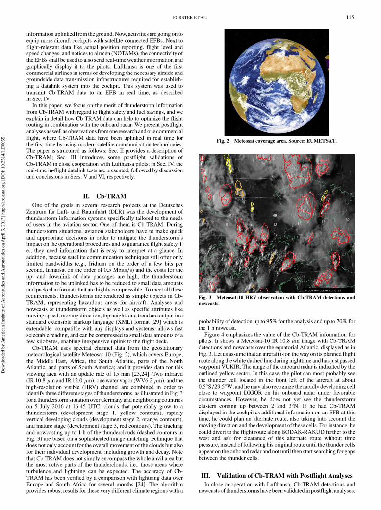
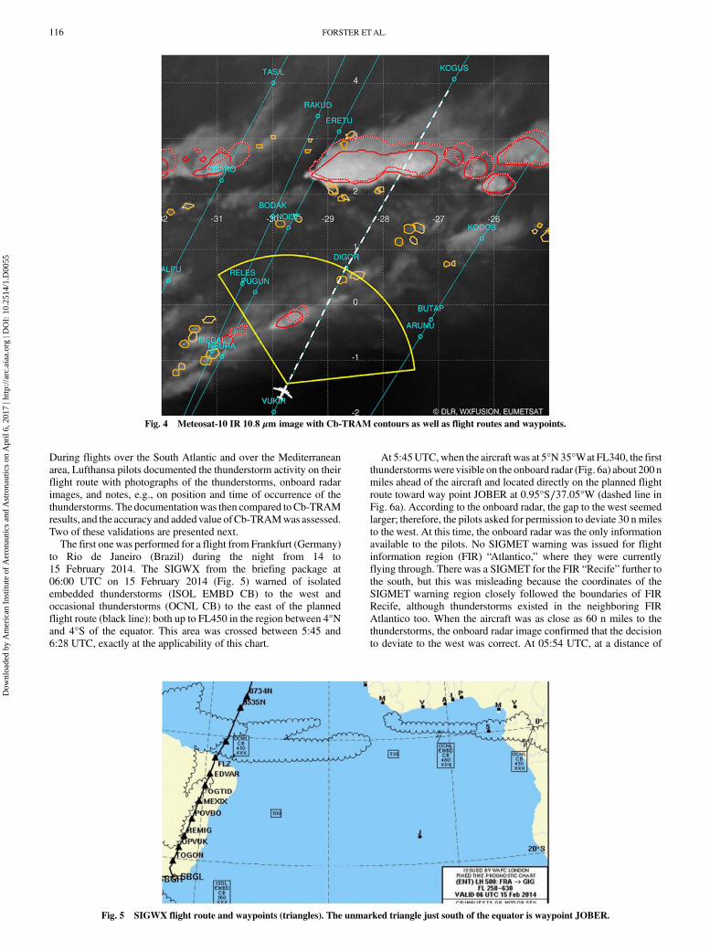
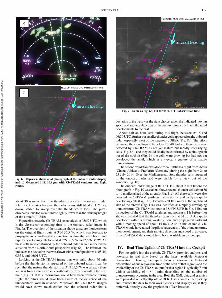
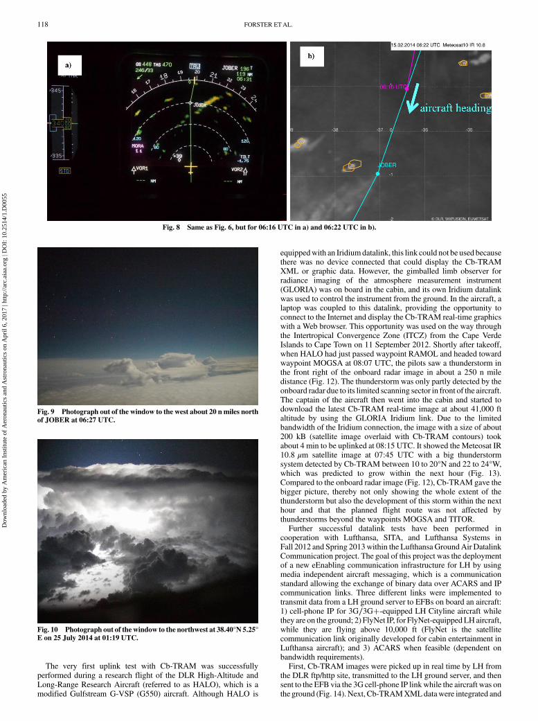
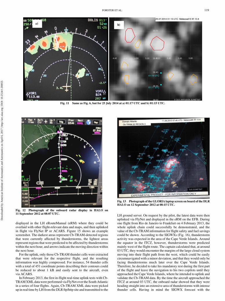
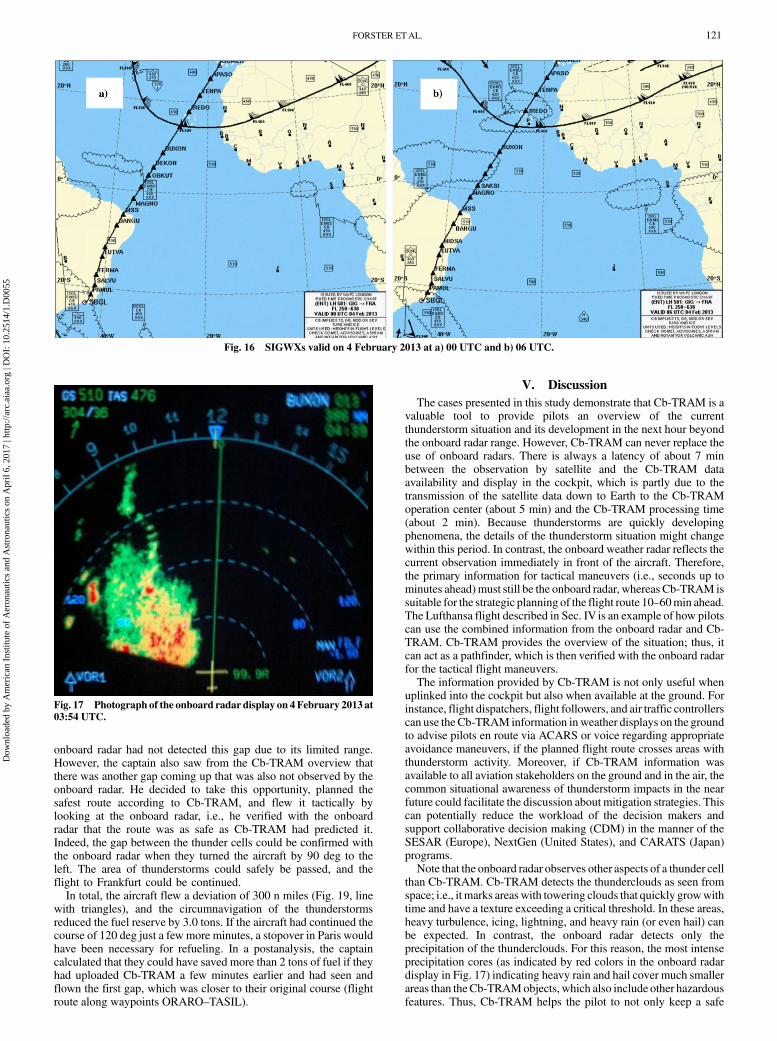
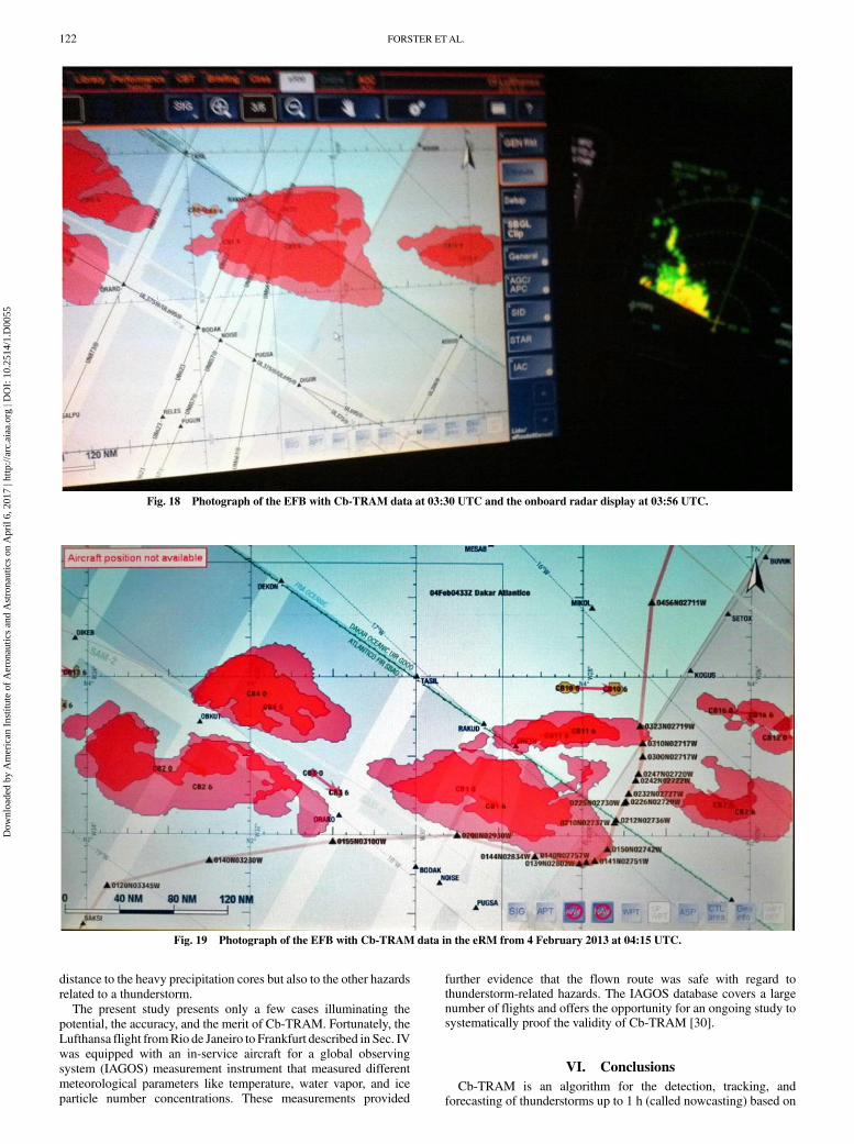
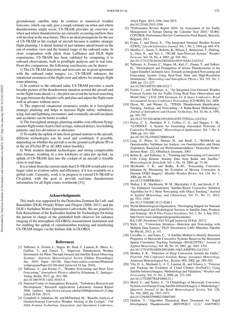