The Tectonic Evolution of Nares Strait: Implications of ... · total opening of Baffin Bay, ......
8
Sedimentbecken nachgezeichnet und zwar genau in dem Gebiet, in dem die Grönland-Platte durch den eozänen bis oligozänen Eureka-Faltengürtel über- schoben wurde. In dieser Region und weiter nordwestlich an Land können die Spuren der Blattverschiebung durch die spätere Kompression verhüllt worden sein. Im südlichen Abschnitt der Nares Strait ist es schwieriger, eine schlüssige Interpretation zu finden. Die aeromagnetischen Daten über dem Kane Basin zeigen in diesem Meeresbecken selbst keinen Versatz. Es wird aber diskutiert, ob sie einen solchen entlang der Ellesmere-Küste zulassen. Spaltspuren- Ergebnisse zeigen, dass das Gebiet zur fraglichen Zeit tektonisch aktiv war, und seismische Ergebnisse südlich des Smith Sound liefern Hinweise auf Lateralbewegungen. Es ist zur Zeit noch nicht möglich, die Aufteilung der Bewegung zwischen der Nares Strait selbst und dem Innern der nordamerika- nischen Platte abzuschätzen. Ein diskutierter Alternativ-Verlauf der Wegener- Störung westlich des Inglefield Uplifts im südlichen Ellesmere Island trifft auf Probleme bei der nötigen Verbindung zur ozeanischen Baffin Bay im Gebiet von Grisefjord. INTRODUCTION It is perhaps paradoxical that a feature that appears at first sight to be a clear case of simple lateral continental motion, and was interpreted as such by both T AYLOR (1910) and WEGENER (1912) in developing the hypothesis of continental drift, should turn out to be so complex and controversial (DAWES & KERR 1982). We believe that the work described in the papers of this volume makes a major contribution to resol- ving some of the problems of the area, although there are still many unanswered questions. Here, we summarise some of the most significant results, and attempt a synthesis for the entire Strait. It should be noted that this is not intended to be a complete summary of the work carried out in connection with the Nares 2001 project; the contributions in fields such as surficial marine geology, oceanography and geodesy are important especially for the recent glacial history of the area, but do not bear directly on its tectonic evolution. In addition, observations can often be interpreted in various ways, and in some cases our attempt to take an overall view results in an interpretation that differs to some extent from that of the authors of the individual papers. TECTONIC SETTING The history of plate motion between Greenland and North America is well constrained by magnetic anomaly patterns in the North Atlantic and Arctic Oceans, as well as the Labrador Sea (HINZ et al. 1979, SRIVASTAVA 1985, SRIVASTAVA & T APS- COTT 1986, ROEST & SRIVASTAVA 1989, CHALMERS & LAURSEN 1995). Greenland, as part of Eurasia, separated from Labrador and Baffin Island in the early stages of North Atlantic opening, with implied strike-slip motion in the present Nares Strait region (Fig. 1). Subsequent development of the North Atlantic spreading axis to the east of Greenland resulted in a 191 Polarforschung 74 (1-3), 191 – 198, 2004 (erschienen 2006) The Tectonic Evolution of Nares Strait: Implications of New Data by Franz Tessensohn 1 , Ruth H. Jackson 2 and Ian D. Reid 3 Abstract: The plate tectonic setting of the research area is well constrained by magnetic anomaly patterns in the surrounding oceans. Greenland as part of Eurasia separated from North America during the Late Cretaceous and the Paleocene, which implied sinistral strike-slip motion in the present Nares Strait region. The direct field evidence for this postulated transform, the Wegener Fault, however, was not very convincing. We provide new data acquired during the Nares Geocruise 2001 and mapping activities on Elles- mere Island in the seasons before. In the northern part of Nares Strait, from the Lincoln Sea to Dobbin Bay, there is consistent evidence for substantial strike-slip motion between Greenland and Ellesmere Island, i.e. for the existence of the Wegener Fault. Onshore, a significant sinistral fault system has been mapped, and dated as Paleocene, i.e. as having been active at the time of Greenland – North America plate motion. Pull-apart basins associated with this fault system can be traced offshore, and the aeromagnetic data also indicate a crustal boundary west of Nares Strait. However, the motion along these faults is not sufficient to accommodate the total opening of Baffin Bay, and intra-plate extension and deformation within the North American Plate is suggested as the source of the remainder. In the Kennedy Channel region, the plate boundary is delineated by a down-faulted sedimentary basin along the coast of Ellesmere Island, where the Greenland Plate is over-thrust by the Eocene to Oligocene Eurekan fold belt. In this region, and in the onshore area to the NW, evidence for strike-slip motion may have been over-ridden by subsequent convergence. In the southern part of the region, it is more difficult to reach a consistent interpretation. The aeromagnetic data from Kane Basin show that there is no significant offset within the basin itself. Whether they permit such an offset along the Ellesmere Island coast remains a matter for discussion. Fission track data suggest that the area was subject to tectonic activity, and seismic data south of Smith Sound also provides evidence in favour of strike-slip motion. It is not yet possible to resolve definitively how motion was partitioned between the Strait itself and the interior of the present North American Plate. A possible alternate route of the Wegener Fault west of the Inglefield Uplift encounters major problems in the Grisefjord area for the structural link with the oceanic Baffin Bay. Zusammenfassung: Der plattentektonische Rahmen des Untersuchungsge- biets ist durch die magnetischen Lineationsmuster in den umgebenden Ozeanen klar umrissen. In der obersten Kreide und im Paläozän trennte sich Grönland als Teil Eurasias von Nordamerika. Dieser Vorgang erforderte eine sinistrale Seitenverschiebung im Gebiet der heutigen Nares Strait. Direkte Feldbelege für die postulierte „Wegener-Transform-Störung“ waren jedoch schwer zu finden. Wir präsentieren hier neue Ergebnisse von einer Messfahrt in der Nares Strait 2001 und von Kartierarbeiten auf dem benachbarten Elles- mere Island in den Jahren zuvor. Im nördlichen Abschnitt der Nares Strait zwischen Lincoln Sea und Dobbin Bay gibt es schlüssige Belege für eine bedeutende Lateralbewegung zwischen Grönland und Ellesmere Island, d.h. für die Existenz der Wegener-Störung. An Land wurde ein größeres sinistrales Blattverschiebungssystem paläozänen Alters kartiert, das zeitlich in die Spanne der Plattenbewegung zwischen Grönland und Nordamerika passt. Pull-apart-Becken, die an diese Störungen gebunden sind, können unter dem Wasser der Nares Strait geophysikalisch verfolgt werden. Die aeromagnetischen Daten deuten außerdem auf eine Krustengrenze im Gebiet unmittelbar westlich der Nares Strait hin. Der Versatz an diesen Störungen ist jedoch nicht groß genug, um den Öffnungsbe- trag der Labrador-See auszugleichen. Hierfür wird Intraplatten-Deformation in der nordamerikanischen Platte vorgeschlagen. Im Kennedy Channel wird die Plattengrenze auf der Seite der Ellesmere Island durch ein küstenparalleles ____________ 1 Bundesanstalt für Geowissenschaften und Rohstoffe, Stilleweg 2, Postfach 30655 Han- nover, Germany. 2 Geological Survey of Canada (Atlantic), Bedford Institute of Oceano-graphie, P.O. Box 1006, Nova Scotia, B2Y 4A2, Canada. 3 Geological Institute, University of Copenhagen, Øster Voldgade 10, 1350 Copenhagen K, Denmark. Manuscript received 15 October 2005, accepted 28 July 2006
Transcript of The Tectonic Evolution of Nares Strait: Implications of ... · total opening of Baffin Bay, ......
Sedimentbecken nachgezeichnet und zwar genau in dem Gebiet, in dem dieGrönland-Platte durch den eozänen bis oligozänen Eureka-Faltengürtel über-schoben wurde. In dieser Region und weiter nordwestlich an Land können dieSpuren der Blattverschiebung durch die spätere Kompression verhüllt wordensein.Im südlichen Abschnitt der Nares Strait ist es schwieriger, eine schlüssigeInterpretation zu finden. Die aeromagnetischen Daten über dem Kane Basinzeigen in diesem Meeresbecken selbst keinen Versatz. Es wird aber diskutiert,ob sie einen solchen entlang der Ellesmere-Küste zulassen. Spaltspuren-Ergebnisse zeigen, dass das Gebiet zur fraglichen Zeit tektonisch aktiv war,und seismische Ergebnisse südlich des Smith Sound liefern Hinweise aufLateralbewegungen. Es ist zur Zeit noch nicht möglich, die Aufteilung derBewegung zwischen der Nares Strait selbst und dem Innern der nordamerika-nischen Platte abzuschätzen. Ein diskutierter Alternativ-Verlauf der Wegener-Störung westlich des Inglefield Uplifts im südlichen Ellesmere Island trifftauf Probleme bei der nötigen Verbindung zur ozeanischen Baffin Bay imGebiet von Grisefjord.
INTRODUCTION
It is perhaps paradoxical that a feature that appears at firstsight to be a clear case of simple lateral continental motion,and was interpreted as such by both TAYLOR (1910) andWEGENER (1912) in developing the hypothesis of continentaldrift, should turn out to be so complex and controversial(DAWES & KERR 1982). We believe that the work described inthe papers of this volume makes a major contribution to resol-ving some of the problems of the area, although there are stillmany unanswered questions. Here, we summarise some of themost significant results, and attempt a synthesis for the entireStrait. It should be noted that this is not intended to be acomplete summary of the work carried out in connection withthe Nares 2001 project; the contributions in fields such assurficial marine geology, oceanography and geodesy areimportant especially for the recent glacial history of the area,but do not bear directly on its tectonic evolution. In addition,observations can often be interpreted in various ways, and insome cases our attempt to take an overall view results in aninterpretation that differs to some extent from that of theauthors of the individual papers.
TECTONIC SETTING
The history of plate motion between Greenland and NorthAmerica is well constrained by magnetic anomaly patterns inthe North Atlantic and Arctic Oceans, as well as the LabradorSea (HINZ et al. 1979, SRIVASTAVA 1985, SRIVASTAVA & TAPS-COTT 1986, ROEST & SRIVASTAVA 1989, CHALMERS & LAURSEN
1995). Greenland, as part of Eurasia, separated from Labradorand Baffin Island in the early stages of North Atlanticopening, with implied strike-slip motion in the present NaresStrait region (Fig. 1). Subsequent development of the NorthAtlantic spreading axis to the east of Greenland resulted in a
191
Polarforschung 74 (1-3), 191 – 198, 2004 (erschienen 2006)
The Tectonic Evolution of Nares Strait: Implications of New Data
by Franz Tessensohn1, Ruth H. Jackson2 and Ian D. Reid3
Abstract: The plate tectonic setting of the research area is well constrained bymagnetic anomaly patterns in the surrounding oceans. Greenland as part ofEurasia separated from North America during the Late Cretaceous and thePaleocene, which implied sinistral strike-slip motion in the present NaresStrait region. The direct field evidence for this postulated transform, theWegener Fault, however, was not very convincing. We provide new dataacquired during the Nares Geocruise 2001 and mapping activities on Elles-mere Island in the seasons before.In the northern part of Nares Strait, from the Lincoln Sea to Dobbin Bay, thereis consistent evidence for substantial strike-slip motion between Greenlandand Ellesmere Island, i.e. for the existence of the Wegener Fault. Onshore, asignificant sinistral fault system has been mapped, and dated as Paleocene, i.e.as having been active at the time of Greenland – North America plate motion.Pull-apart basins associated with this fault system can be traced offshore, andthe aeromagnetic data also indicate a crustal boundary west of Nares Strait.However, the motion along these faults is not sufficient to accommodate thetotal opening of Baffin Bay, and intra-plate extension and deformation withinthe North American Plate is suggested as the source of the remainder. In theKennedy Channel region, the plate boundary is delineated by a down-faultedsedimentary basin along the coast of Ellesmere Island, where the GreenlandPlate is over-thrust by the Eocene to Oligocene Eurekan fold belt. In thisregion, and in the onshore area to the NW, evidence for strike-slip motion mayhave been over-ridden by subsequent convergence.In the southern part of the region, it is more difficult to reach a consistentinterpretation. The aeromagnetic data from Kane Basin show that there is nosignificant offset within the basin itself. Whether they permit such an offsetalong the Ellesmere Island coast remains a matter for discussion. Fission trackdata suggest that the area was subject to tectonic activity, and seismic datasouth of Smith Sound also provides evidence in favour of strike-slip motion. Itis not yet possible to resolve definitively how motion was partitioned betweenthe Strait itself and the interior of the present North American Plate. Apossible alternate route of the Wegener Fault west of the Inglefield Upliftencounters major problems in the Grisefjord area for the structural link withthe oceanic Baffin Bay.
Zusammenfassung: Der plattentektonische Rahmen des Untersuchungsge-biets ist durch die magnetischen Lineationsmuster in den umgebendenOzeanen klar umrissen. In der obersten Kreide und im Paläozän trennte sichGrönland als Teil Eurasias von Nordamerika. Dieser Vorgang erforderte einesinistrale Seitenverschiebung im Gebiet der heutigen Nares Strait. DirekteFeldbelege für die postulierte „Wegener-Transform-Störung“ waren jedochschwer zu finden. Wir präsentieren hier neue Ergebnisse von einer Messfahrtin der Nares Strait 2001 und von Kartierarbeiten auf dem benachbarten Elles-mere Island in den Jahren zuvor. Im nördlichen Abschnitt der Nares Strait zwischen Lincoln Sea und DobbinBay gibt es schlüssige Belege für eine bedeutende Lateralbewegung zwischenGrönland und Ellesmere Island, d.h. für die Existenz der Wegener-Störung. AnLand wurde ein größeres sinistrales Blattverschiebungssystem paläozänenAlters kartiert, das zeitlich in die Spanne der Plattenbewegung zwischenGrönland und Nordamerika passt. Pull-apart-Becken, die an diese Störungengebunden sind, können unter dem Wasser der Nares Strait geophysikalischverfolgt werden. Die aeromagnetischen Daten deuten außerdem auf eineKrustengrenze im Gebiet unmittelbar westlich der Nares Strait hin. DerVersatz an diesen Störungen ist jedoch nicht groß genug, um den Öffnungsbe-trag der Labrador-See auszugleichen. Hierfür wird Intraplatten-Deformationin der nordamerikanischen Platte vorgeschlagen. Im Kennedy Channel wirddie Plattengrenze auf der Seite der Ellesmere Island durch ein küstenparalleles
____________1 Bundesanstalt für Geowissenschaften und Rohstoffe, Stilleweg 2, Postfach 30655 Han-
nover, Germany.2 Geological Survey of Canada (Atlantic), Bedford Institute of Oceano-graphie, P.O. Box
1006, Nova Scotia, B2Y 4A2, Canada.3 Geological Institute, University of Copenhagen, Øster Voldgade 10, 1350 Copenhagen
K, Denmark.
Manuscript received 15 October 2005, accepted 28 July 2006
change of motion, with northward motion of Greenland produ-cing convergence and compression between Greenland andEllesmere Island, which is manifested geologically in theEurekan fold belt to the northwest of Nares Strait.
The plate reconstructions themselves show that the interpreta-tion of the Strait as a simple strike-slip fault, the “WegenerFault” of WILSON (1965) is an oversimplification. It is there-fore not surprising that the geological evidence for such a faultis, at best, fragmentary. HARRISON (this vol. 2006) provides anoverview of the geological evidence for and against lateraloffsets, and finds significant differences between the northernand southern parts of the Strait. Since these were the tworegions that were particularly investigated by the Nares 2001project, we will consider the new geophysical and geologicaldata from each of these separately, before attempting anoverall synthesis.
NORTHERN NARES STRAIT
Strike-slip faults with a substantial amount of sinistral offsethave been identified on northeast Ellesmere Island (MAYR &DEVRIES 1982, MAYR et al. in press). Based on a number ofassumptions, HARRISON (this vol. 2006) estimates the totalamount of slip on the Judge Daly fault system to be 65-75 km,and interprets it as the local geological expression of theWegener Fault. An implication of this interpretation is that part
of the Greenland plate is in fact exposed on Ellesmere Island.If this is the case, the basement of northern Nares Strait, in theKennedy Channel region, should be continuous with that ofGreenland.
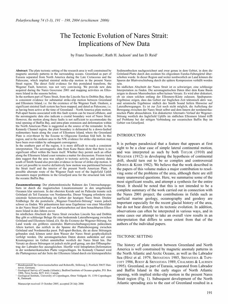
The new geophysical data (DAMASKE & OAKEY this vol. 2006)provides strong evidence in favour of this interpretation. Theaeromagnetic survey shows a systematic variation in theamplitude of the regional magnetic anomalies (Fig. 2). Theyare positive over Greenland and as far west as the coast ofEllesmere Island. These anomalies have been attributed toArchean basement rocks overlain by nonmagnetic Silurian andDevonian carbonates. The contrasting negative magneticanomalies of Ellesmere Island suggest a different basement.The change in amplitudes from positive to negative can beinterpreted as supporting evidence of a crustal boundary inNares Strait. This boundary can be traced from the LincolnSea to the vicinity of Franklin Island in Kennedy Channel.
The magnetic data also provide evidence for offshore exten-sion of the Judge Daly fault system. Geological investigationsof the region associated with two parallel linear magneticanomalies on the Judge Daly Promontory found that basalticclasts in sedimentary basins bounded by sinistral faults areresponsible for the anomalies. These linear anomalies and, byimplication, the associated fault-bounded basins, can be
192
Fig. 1: Plate Tectonic Setting during the Late Cretaceous to Paleocene. Duringopening of Labrador Sea and Baffin Bay, the Greenland plate as part of theEuasian plate moved to the NE, causing sinistral strike-slip faults in the areaof Davis and Nares straits.
Fig. 2: Aeromagnetic map of the Hall Basin area from DAMASKE & OAKEY
(this vol. 2006), combined with selected geological features (inset) onshore.Paleocene sedimentary basins (crosshatched) contain volcanogenic sandsto-nes with strong magnetic signature, which continues offshore to the north andsouth. The signature stops in the southernmost (Cape Back) basin, where thicklimestone conglomerates replace the sandstone facies.
readily traced offshore. They have a shallow source of a kilo-metre or less, and are located to the east of the transition frommainly positive to mainly negative anomalies that is inter-preted as the crustal boundary. The association of the magneticlineations with onshore sinistral strike-slip faults, and datingof the clasts as Paleocene, provide a sharp delineation in spaceand time of the distal edge of the Ellesmere Island plate.
Fission track measurements from the Judge Daly Promontory(GRIST & ZENTILLI this vol. 2006) provide valuable informa-tion on the timing of the movements. The fission track agesfrom the Pavy Formation of Cape Back are indistinguishablefrom volcanic provenance ages of 58.5-61.2 Ma (ESTRADA etal. in press), and are consistent with active volcanism thatcould be related to rift transform volcanism. The fault-bounded Pavy River system may therefore represent theexposed portion of the Wegener Fault system, parts of which
may be thrust-overridden further south. The fission track dataare compatible with extensive strike-slip motion during thelate Paleocene (GRIST & ZENTILLI this vol. 2006).
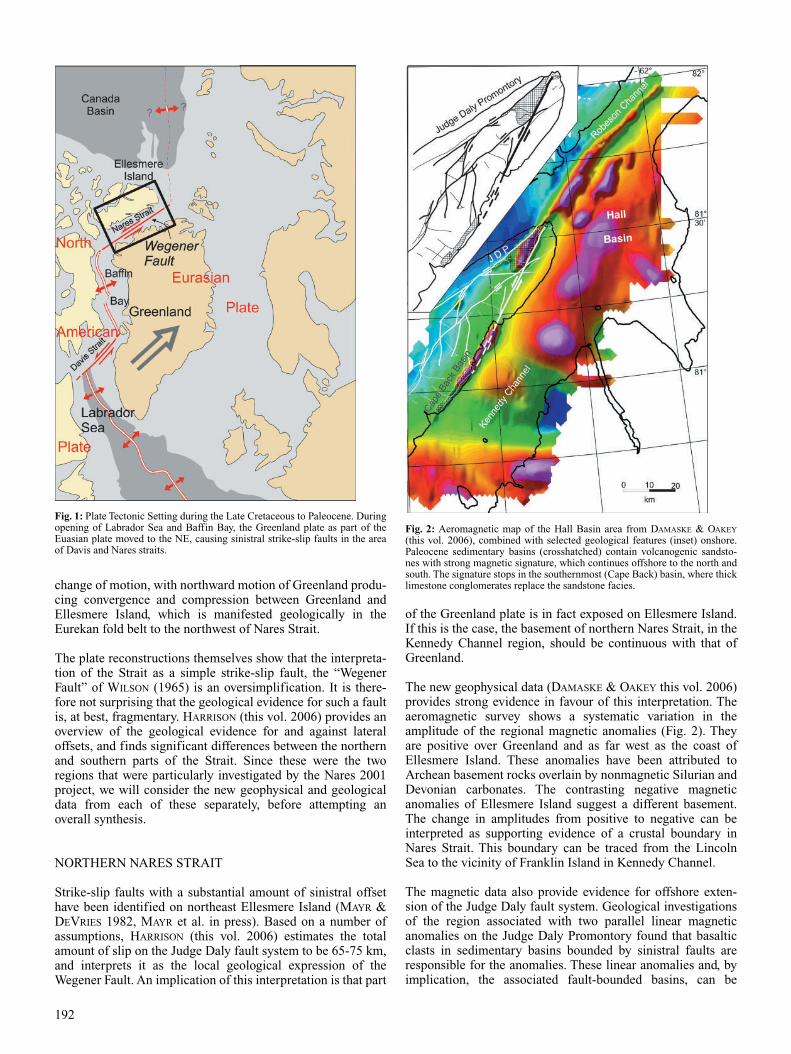
Seismic data are obviously crucial for determining the natureof the Nares Strait basement and the location of any offshorefaults. The seismic reflection survey completed during thisproject (JACKSON et al. this vol. 2006) succeeded in determi-ning several important characteristics of the seabed and sub-sea floor in north-eastern Kane Basin, Kennedy Channel andHall Basin (Fig. 3). Adjacent to the coast of Ellesmere Islandat Cape Lawrence, a continuation of the Franklin Pierce sedi-mentary basin is present (Fig. 3b). The basin is fault-boundedand asymmetric, deepest near the Ellesmere Island coast. Avertical throw of over a kilometre is required on the coastalfault scarp. Industry seismic data (RENDELL & CRAIG 1976)show that the Franklin Pierce Basin in north western Kane
193
Fig. 3: Selected seismic lines in Kennedy Channel after JACKSON, DEHLER et al. (this vol. 2006). Line BGR 09 shows contact between front thrust of Ellesmeriansystem in contact with carbonate platform of Greenland side. Line BGR 21-21a runs almost N–S, but crosses diagonally an offshore sedimentary basin south ofCape Lawrence. Line 15 from RENDELL & CRAIG (1976) crosses the same basin near Dobbin Bay.
Basin is also asymmetric, and deepest near the EllesmereIsland coast (Fig. 3c). A steep coastal fault terminates theEurekan thrusts sheets in the Dobbin Bay area.
Ice conditions further north in Kennedy Channel preventedsurveying near the Ellesmere Island coast, so it was notpossible to establish the presence of a corresponding basinhere. In the area surveyed, the Strait is underlain by a reflectorwith a hard surface and no internal structure. Refraction data(FUNCK, DEHLER et al. this vol. 2006) indicate velocities of 5.8km s-1 at the surface in the east of the area and 6.1 km s-1 in thewest. These velocities are consistent with a carbonate plat-form, dipping away from the Greenland coast that extendsacross most of the channel (Fig. 3a). Carbonate platform andreefal mounds are exposed on Hans Island and along theGreenland coast. In the central and eastern part of KennedyChannel there is no evidence of faulting. The reflection andrefraction results support the interpretation that the crustacross most of Nares Strait is of Greenland affinity.
The new geophysical information: magnetics, seismic reflec-tion and refraction profiles, together with fission track dataand recent publications on the geology of the Judge DalyPromontory (MAYR et al. in press), allow the faulted contactbetween Greenland and Ellesmere Island crust to be tracedalong the coast of Ellesmere Island from the Lincoln Sea intonorth-eastern Kane Basin. The observed sinistral offset of theJudge Daly Fault System supports identification of this as aprimary locus of strike-slip motion along the Strait. However,the 65-75 km offset suggested by HARRISON (this vol. 2006) isnot sufficient to account for the offset required for the openingof Baffin Bay. HARRISON (this vol. 2006) suggests that theremainder of the offset may be taken up further inland, in theSverdrup Basin, and by extension across Lancaster and JonesSounds, effectively decoupling Ellesmere Island from the restof North America. There is also the possibility that much ofthe evidence for strike-slip motion was obliterated by the thru-sting associated with convergence of the Eurekan orogeny.
Nevertheless, this feature, which matches most closely theoriginal definition of the Wegener Fault, can be identified withsome confidence in the nothern part of Nares Strait.
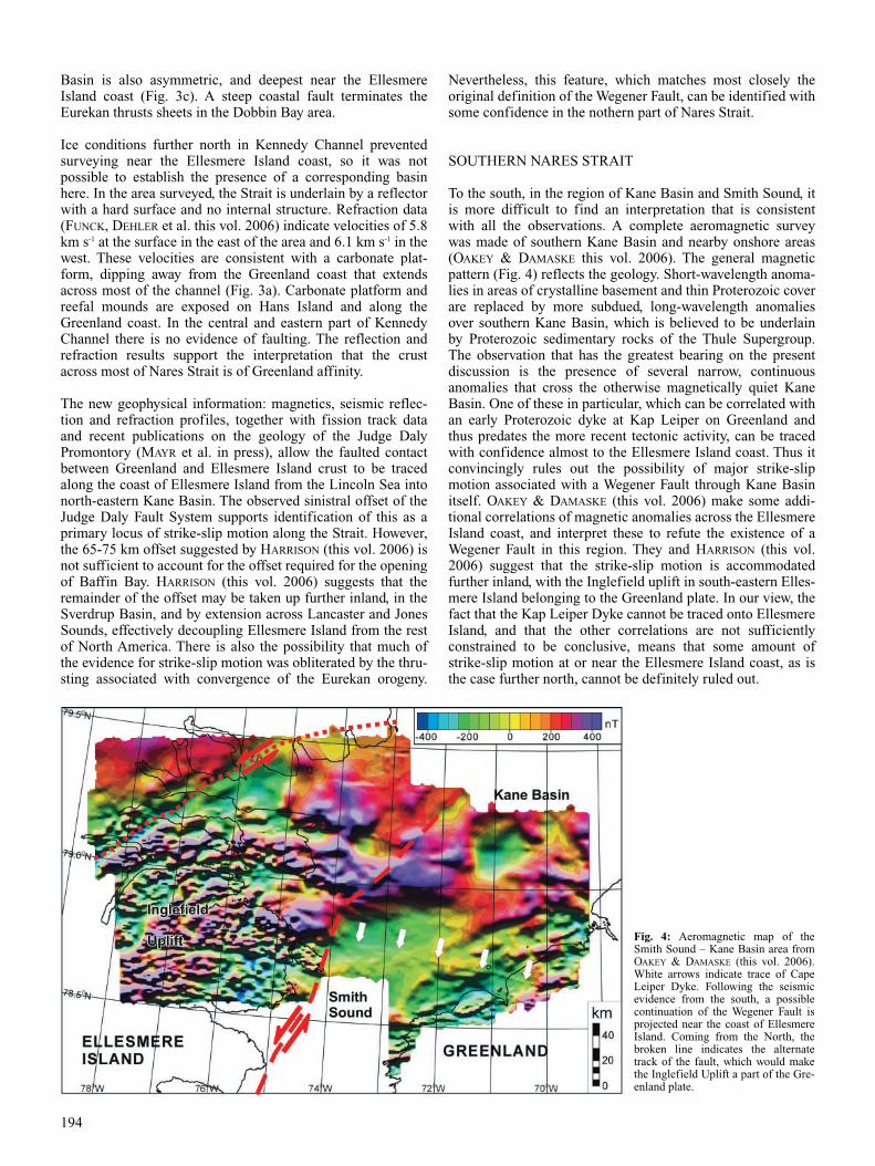
SOUTHERN NARES STRAIT
To the south, in the region of Kane Basin and Smith Sound, itis more difficult to find an interpretation that is consistentwith all the observations. A complete aeromagnetic surveywas made of southern Kane Basin and nearby onshore areas(OAKEY & DAMASKE this vol. 2006). The general magneticpattern (Fig. 4) reflects the geology. Short-wavelength anoma-lies in areas of crystalline basement and thin Proterozoic coverare replaced by more subdued, long-wavelength anomaliesover southern Kane Basin, which is believed to be underlainby Proterozoic sedimentary rocks of the Thule Supergroup.The observation that has the greatest bearing on the presentdiscussion is the presence of several narrow, continuousanomalies that cross the otherwise magnetically quiet KaneBasin. One of these in particular, which can be correlated withan early Proterozoic dyke at Kap Leiper on Greenland andthus predates the more recent tectonic activity, can be tracedwith confidence almost to the Ellesmere Island coast. Thus itconvincingly rules out the possibility of major strike-slipmotion associated with a Wegener Fault through Kane Basinitself. OAKEY & DAMASKE (this vol. 2006) make some addi-tional correlations of magnetic anomalies across the EllesmereIsland coast, and interpret these to refute the existence of aWegener Fault in this region. They and HARRISON (this vol.2006) suggest that the strike-slip motion is accommodatedfurther inland, with the Inglefield uplift in south-eastern Elles-mere Island belonging to the Greenland plate. In our view, thefact that the Kap Leiper Dyke cannot be traced onto EllesmereIsland, and that the other correlations are not sufficientlyconstrained to be conclusive, means that some amount ofstrike-slip motion at or near the Ellesmere Island coast, as isthe case further north, cannot be definitely ruled out.
194
Fig. 4: Aeromagnetic map of theSmith Sound – Kane Basin area fromOAKEY & DAMASKE (this vol. 2006).White arrows indicate trace of CapeLeiper Dyke. Following the seismicevidence from the south, a possiblecontinuation of the Wegener Fault isprojected near the coast of EllesmereIsland. Coming from the North, thebroken line indicates the alternatetrack of the fault, which would makethe Inglefield Uplift a part of the Gre-enland plate.
Thermal models for samples from sea level dykes from aroundSmith Sound suggest a period of Late Cretaceous – Paleoceneheating prior to the final cooling during the Paleocene (GRIST
& ZENTILLI this vol. 2006). These observations tend to opposethe implication of HARRISON’s (this vol. 2006) model, in whichSmith Sound is entirely within the Greenland plate, andremote from any tectonic activity at this time.
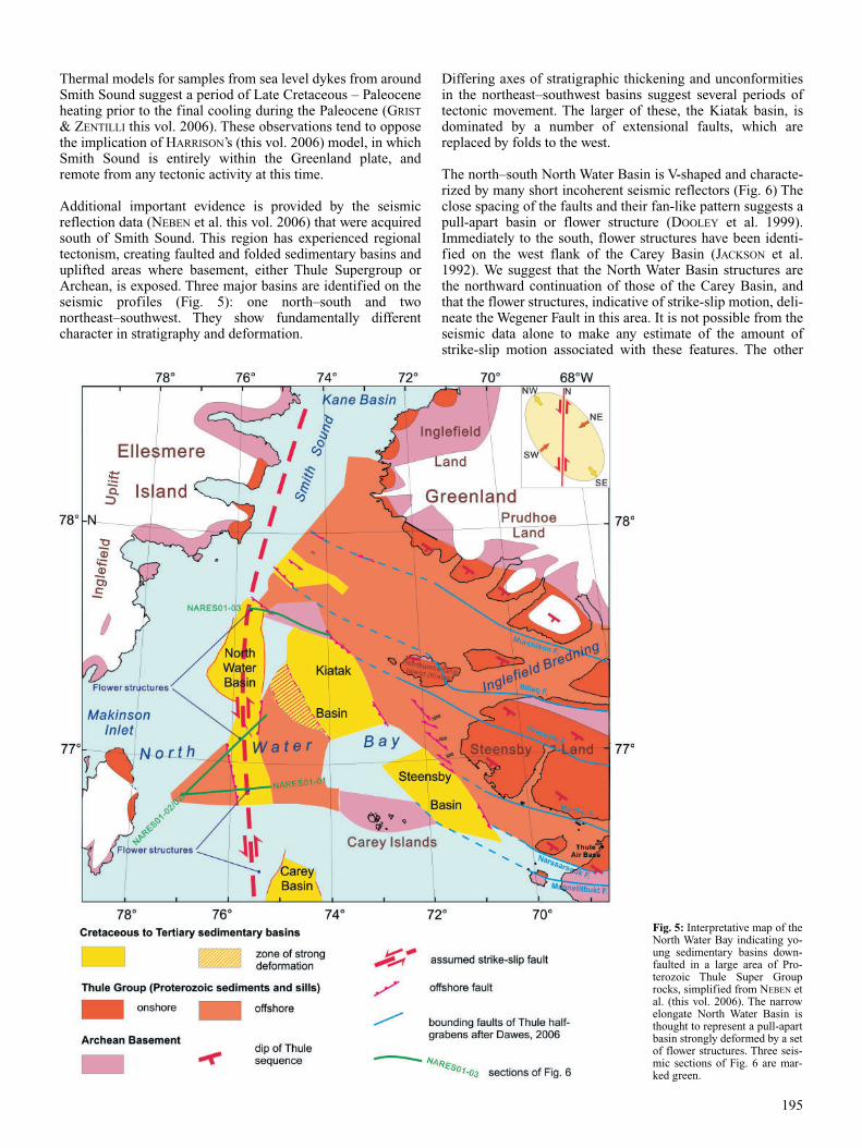
Additional important evidence is provided by the seismicreflection data (NEBEN et al. this vol. 2006) that were acquiredsouth of Smith Sound. This region has experienced regionaltectonism, creating faulted and folded sedimentary basins anduplifted areas where basement, either Thule Supergroup orArchean, is exposed. Three major basins are identified on theseismic profiles (Fig. 5): one north–south and twonortheast–southwest. They show fundamentally differentcharacter in stratigraphy and deformation.
Differing axes of stratigraphic thickening and unconformitiesin the northeast–southwest basins suggest several periods oftectonic movement. The larger of these, the Kiatak basin, isdominated by a number of extensional faults, which arereplaced by folds to the west.
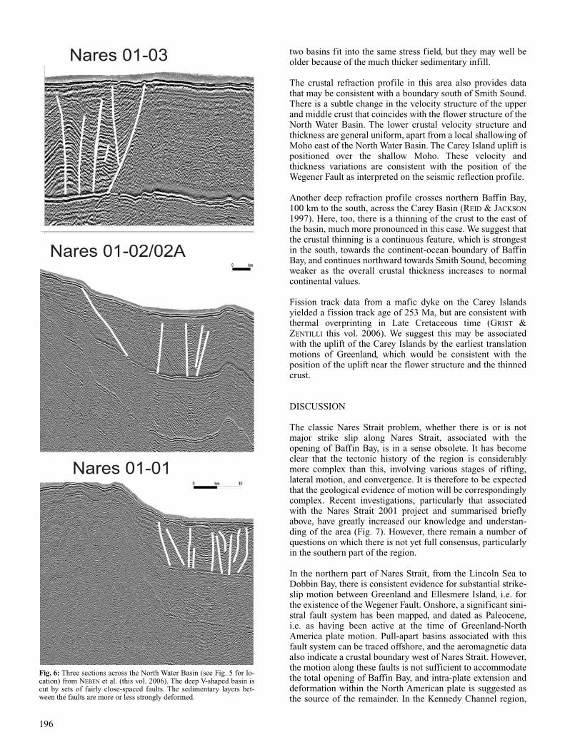
The north–south North Water Basin is V-shaped and characte-rized by many short incoherent seismic reflectors (Fig. 6) Theclose spacing of the faults and their fan-like pattern suggests apull-apart basin or flower structure (DOOLEY et al. 1999).Immediately to the south, flower structures have been identi-fied on the west flank of the Carey Basin (JACKSON et al.1992). We suggest that the North Water Basin structures arethe northward continuation of those of the Carey Basin, andthat the flower structures, indicative of strike-slip motion, deli-neate the Wegener Fault in this area. It is not possible from theseismic data alone to make any estimate of the amount ofstrike-slip motion associated with these features. The other
195
Fig. 5: Interpretative map of theNorth Water Bay indicating yo-ung sedimentary basins down-faulted in a large area of Pro-terozoic Thule Super Grouprocks, simplified from NEBEN etal. (this vol. 2006). The narrowelongate North Water Basin isthought to represent a pull-apartbasin strongly deformed by a setof flower structures. Three seis-mic sections of Fig. 6 are mar-ked green.
two basins fit into the same stress field, but they may well beolder because of the much thicker sedimentary infill.
The crustal refraction profile in this area also provides datathat may be consistent with a boundary south of Smith Sound.There is a subtle change in the velocity structure of the upperand middle crust that coincides with the flower structure of theNorth Water Basin. The lower crustal velocity structure andthickness are general uniform, apart from a local shallowing ofMoho east of the North Water Basin. The Carey Island uplift ispositioned over the shallow Moho. These velocity andthickness variations are consistent with the position of theWegener Fault as interpreted on the seismic reflection profile.
Another deep refraction profile crosses northern Baffin Bay,100 km to the south, across the Carey Basin (REID & JACKSON
1997). Here, too, there is a thinning of the crust to the east ofthe basin, much more pronounced in this case. We suggest thatthe crustal thinning is a continuous feature, which is strongestin the south, towards the continent-ocean boundary of BaffinBay, and continues northward towards Smith Sound, becomingweaker as the overall crustal thickness increases to normalcontinental values.
Fission track data from a mafic dyke on the Carey Islandsyielded a fission track age of 253 Ma, but are consistent withthermal overprinting in Late Cretaceous time (GRIST &ZENTILLI this vol. 2006). We suggest this may be associatedwith the uplift of the Carey Islands by the earliest translationmotions of Greenland, which would be consistent with theposition of the uplift near the flower structure and the thinnedcrust.
DISCUSSION
The classic Nares Strait problem, whether there is or is notmajor strike slip along Nares Strait, associated with theopening of Baffin Bay, is in a sense obsolete. It has becomeclear that the tectonic history of the region is considerablymore complex than this, involving various stages of rifting,lateral motion, and convergence. It is therefore to be expectedthat the geological evidence of motion will be correspondinglycomplex. Recent investigations, particularly that associatedwith the Nares Strait 2001 project and summarised brieflyabove, have greatly increased our knowledge and understan-ding of the area (Fig. 7). However, there remain a number ofquestions on which there is not yet full consensus, particularlyin the southern part of the region.
In the northern part of Nares Strait, from the Lincoln Sea toDobbin Bay, there is consistent evidence for substantial strike-slip motion between Greenland and Ellesmere Island, i.e. forthe existence of the Wegener Fault. Onshore, a significant sini-stral fault system has been mapped, and dated as Paleocene,i.e. as having been active at the time of Greenland-NorthAmerica plate motion. Pull-apart basins associated with thisfault system can be traced offshore, and the aeromagnetic dataalso indicate a crustal boundary west of Nares Strait. However,the motion along these faults is not sufficient to accommodatethe total opening of Baffin Bay, and intra-plate extension anddeformation within the North American plate is suggested asthe source of the remainder. In the Kennedy Channel region,
196
Fig. 6: Three sections across the North Water Basin (see Fig. 5 for lo-cation) from NEBEN et al. (this vol. 2006). The deep V-shaped basin iscut by sets of fairly close-spaced faults. The sedimentary layers bet-ween the faults are more or less strongly deformed.
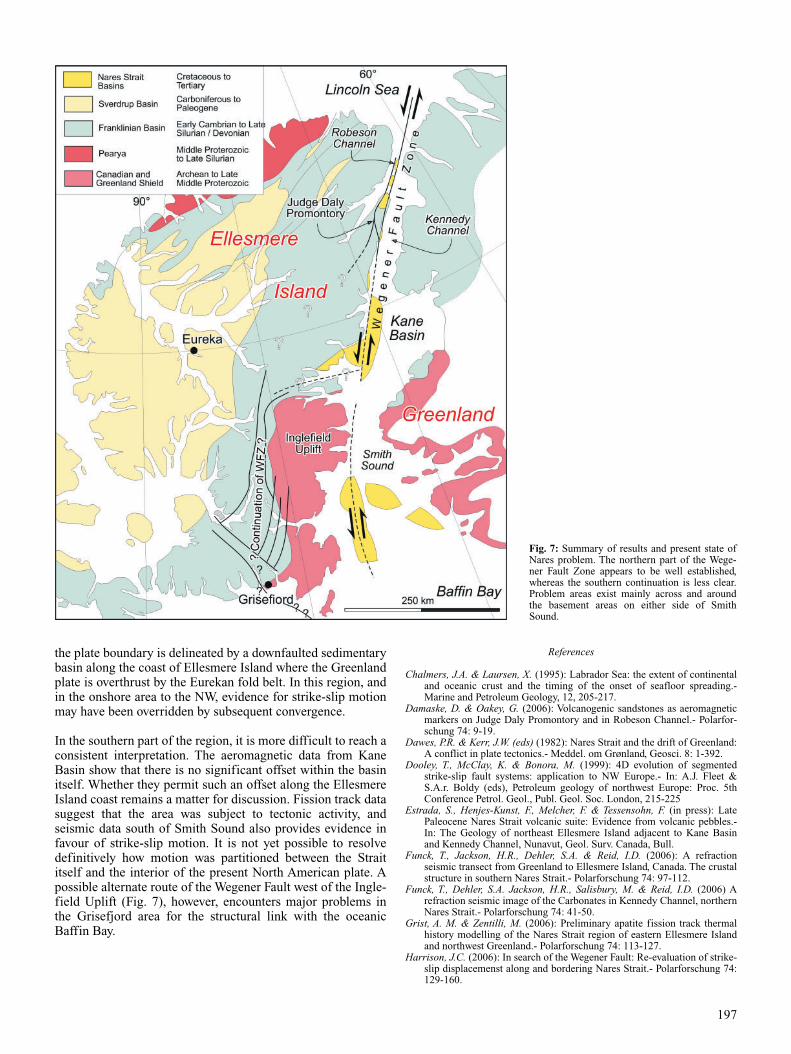
the plate boundary is delineated by a downfaulted sedimentarybasin along the coast of Ellesmere Island where the Greenlandplate is overthrust by the Eurekan fold belt. In this region, andin the onshore area to the NW, evidence for strike-slip motionmay have been overridden by subsequent convergence.
In the southern part of the region, it is more difficult to reach aconsistent interpretation. The aeromagnetic data from KaneBasin show that there is no significant offset within the basinitself. Whether they permit such an offset along the EllesmereIsland coast remains a matter for discussion. Fission track datasuggest that the area was subject to tectonic activity, andseismic data south of Smith Sound also provides evidence infavour of strike-slip motion. It is not yet possible to resolvedefinitively how motion was partitioned between the Straititself and the interior of the present North American plate. Apossible alternate route of the Wegener Fault west of the Ingle-field Uplift (Fig. 7), however, encounters major problems inthe Grisefjord area for the structural link with the oceanicBaffin Bay.
References
Chalmers, J.A. & Laursen, X. (1995): Labrador Sea: the extent of continentaland oceanic crust and the timing of the onset of seafloor spreading.-Marine and Petroleum Geology, 12, 205-217.
Damaske, D. & Oakey, G. (2006): Volcanogenic sandstones as aeromagneticmarkers on Judge Daly Promontory and in Robeson Channel.- Polarfor-schung 74: 9-19.
Dawes, P.R. & Kerr, J.W. (eds) (1982): Nares Strait and the drift of Greenland:A conflict in plate tectonics.- Meddel. om Grønland, Geosci. 8: 1-392.
Dooley, T., McClay, K. & Bonora, M. (1999): 4D evolution of segmentedstrike-slip fault systems: application to NW Europe.- In: A.J. Fleet &S.A.r. Boldy (eds), Petroleum geology of northwest Europe: Proc. 5thConference Petrol. Geol., Publ. Geol. Soc. London, 215-225
Estrada, S., Henjes-Kunst, F., Melcher, F. & Tessensohn, F. (in press): LatePaleocene Nares Strait volcanic suite: Evidence from volcanic pebbles.-In: The Geology of northeast Ellesmere Island adjacent to Kane Basinand Kennedy Channel, Nunavut, Geol. Surv. Canada, Bull.
Funck, T., Jackson, H.R., Dehler, S.A. & Reid, I.D. (2006): A refractionseismic transect from Greenland to Ellesmere Island, Canada. The crustalstructure in southern Nares Strait.- Polarforschung 74: 97-112.
Funck, T., Dehler, S.A. Jackson, H.R., Salisbury, M. & Reid, I.D. (2006) Arefraction seismic image of the Carbonates in Kennedy Channel, northernNares Strait.- Polarforschung 74: 41-50.
Grist, A. M. & Zentilli, M. (2006): Preliminary apatite fission track thermalhistory modelling of the Nares Strait region of eastern Ellesmere Islandand northwest Greenland.- Polarforschung 74: 113-127.
Harrison, J.C. (2006): In search of the Wegener Fault: Re-evaluation of strike-slip displacemenst along and bordering Nares Strait.- Polarforschung 74:129-160.
197
Fig. 7: Summary of results and present state ofNares problem. The northern part of the Wege-ner Fault Zone appears to be well established,whereas the southern continuation is less clear.Problem areas exist mainly across and aroundthe basement areas on either side of Smith Sound.
Hinz, K., Schlüter, H-U., Grant, A.C., Srivastava, S.P., Umpleby, D.,& Wood-side, J. (1979): Geophysical transects of the Labrador Sea: Labrador tosouthwest Greenland.- Tectonophysics 59: 151-183.
Jackson, H.R., Dickie, K. & Marillier, F. (1992): A seismic reflection study ofnorthern Baffin Bay: Implication for tectonic evolution.- Can. J. EarthSci. 29: 2353-2369.
Jackson,H.R., Hannon, T., Neben, S., Piepjohn, K. & Brent (2006): Seismicreflection profiles from Kane to Hall Basin, Nares Strait: Evidence forfaulting.- Polarforschung 74: 21-39.
Mayr, U. & de Vries, C.D.S. (1982): Reconnaissance of the Tertiary structuresalong Nares Strait, Ellesmere Island, Canadian Arctic Archipelago.- In:P.R. DAWES & J.W. KERR (eds), Nares Strait and the drift of Greenland:A conflict in plate tectonics.- Meddel. om Grønland, Geosci. 8: 167-175.
Mayr, U., Tessensohn, F., Buggisch, W., de Freitas, T., Dewing, K., Estrada, S.,von Gosen, W., Harrison, J.C., Henjes-Kunst, F., Lee, C., Lehnert, O.,Melcher, F., Nowlan, G.S., Piepjohn, K., Saalmann, K. & Sweet, A.R. (inpress): The Geology of northeast Ellesmere Island adjacent to Kane Basinand Kennedy Channel, Nunavut.- Geol. Surv. Canada Bull.
Neben, S., Damm, V., Brent, T. & Tessensohn, F. (2006): New multichannelseismic reflection data from North Water Bay, Nares Strait: Indicationsfor pull-apart tectonics.- Polarforschung 74: 77-96.
Oakey, G. & Damaske, D. (2006): Structural elements of the Kane Basin
region of Nares Strait, constrained by aeromagnetic data.- Polarforschung74: 51-62.
Reid, I.D. & Jackson, H.R. (1997): Crustal structure of northern Baffin Bay.Seismic refraction results and tectonic implications.- J. Geophys. Res.102: 523-542.
Rendell, G. & Craig, R.W. (1976): Seismic report for Kane Basin, offshoreEllesmere Island.- Dept. Indian & Northern Affairs, Rep. 076-09-10-34:1-19.
Roest ,W. & Srivastava, S.P. (1989): Seafloor spreading in the Labrador Sea: Anew reconstruction.- Geology 17: 1000-1003.
Srivastava, S.P. (1985): Evolution of the Eurasian Basin and its implications tothe motion of Greenland along Nares Strait.- Tectonophysics 114: 29-53.
Srivastava, S.P. & Tapscott, C.R. (1986): Plate kinematics of the NorthAtlantic.- In: P.R.VOGT & B.E. TUCHOLKE (eds), The western NorthAtlantic region.- Geol. Soc. Amer., The Geology of North America, vol.M: 379-404.
Taylor, F.B. (1910): Bearing on Tertiary Mountain belts and on the origin ofthe earth’s plan.- Bull. Geol. Soc. Amer. 21: 179-226.
Wegener, A. (1912): Die Entstehung der Kontinente.- Geol. Rundschau 3: 276-292.
Wilson, J.T. (1965): A new class of faults and their bearing on continentaldrift.- Nature 207: 343-347.
198