( P R Ä S E N T A T I O N S T A R T E T S E L B S T S T Ä N D I G )
!!
!
!
!
!
!
!!
!
!
!
!
!
!
!
!!
!
!
!
!!
!
!
!!
!
!!
!
!
! !! !
!
! !!
!!
!
!
!!
!
!
!
!
!
!!
!!
!
!
!!
!
!
!
!
!
!
!!
!
!
!
!
!
!
!
!!
!
!
!
!
!
!
!
!!
!!
!
!
!
!!
!!
!
!
!
!
!
!!
!!
! !
!
!
!
!
!
!!
!
!
!
!!
!!
!!
!
!
!
!!
!
!
!
!
!
!
!!
!
!!
!
!
!
!!
!
!!
!
!
!
!
!!!!!
!
!!
!
!
!
!
!!
!!
!
!
!
!
!
!
!
!
!
! !
!
! !
!
!
!
!
!
!
! !
!!
!
!!
!!
!!
!
!
!
!
!
!
!
!
!
!
!
!
!
!
! !
!
!
!
!
!
!
!
!
!
! !
!
!
!
!!
!
!
!
!!
!
!
!!
!
!
!
!!
!
!
! !
!
!
!
!
!
!!
!
!!
!
!
!
!
!
!
!!
!
!
!!
!
! !
! !
!!
!!
!!
!
!
!
!
!!
! !
! ! !
!
!
!!
!
!
!
!
!!
!!
!
!
!
!!
!
!!
! !
! !
!!
!
!
!
!
!
!
!
!
!
!!
!!
!!
!
! !
!
!
! !
!
!
!
!!
!
!!
!!!
!!
!!!
!
!
!!
!!!!!
!!
! ! ! ! !
!
!!!!!!
!!
!
! !
!!
!
!
!
!!
!
!
!
!
!
!
!
!
!
!
!
!
!
!
!!!!!!
!!
!!
!
! !
!!
!!
!
!
!
!
!
!
!
!
!!!!!!!
!!
!!
! ! ! ! !
!!
!!
!
! ! ! ! !
!!
!!
!
! ! ! ! !
!!
!!
!
!!!!!!!
!!
!
!!!!!!!
!!
!
! !
!
!
!
!
! !
!
!
!
!
!!
!
!
!
!
!
!
!
!
!!
!!
!!
!!
!!
!
!!!!!!!!!
! ! ! !
!!
!
!
!
!
!
!!
!!
!
!
!
!!
!
!!
!
!
!
!
!
!
!
!
!!
!
!
!
!
!!
!
!
!
!
!!
!
! ! !!
!
! ! !!
!!
!!
! ! ! ! !
!!
!!
!
! ! ! ! !
!!
!!
!!
!
!
!
!!!!
!!
!!
!
! ! ! !
!!
! !
!!
! ! ! ! ! !
!!
!!
!
!!!!!!!!!!
!!
!!
!
!!!!!!!
!!
!
!!!!!
!!
!!
!
!!!
!!
!!
!
! !
!!
!
!
!! ! ! ! !
!
! ! ! ! ! ! ! ! ! ! ! !
!!
!!
!
! ! !
!!
! ! !
!
!!
!
!!
! ! ! ! ! ! ! !
!!
!!
! !!
!
!
! ! !
!! ! ! ! ! ! ! ! ! !
!!
!!!
!
!
!
!!
!
! ! !
!
!!
!!!!!!!
!!
!!
!!!
!
!!!
!!
!
!!!!!
!!
!!
!
!!
!
!
!!
!
!
!!
!!
!
!
!!!
!!
!!
!
!
!
!!!
!
!!
!!
!!!!!
!!
!
!
!
!
!
!
!
!
!!
!
!
!
!
!
!
!
!
!!!
!!
!!
!!
!!
! !
!
!!!
!
! ! ! ! !
!!
!
!!
! ! ! ! ! !
!!
!!
!!!!!!
!!
!!
!
!!
!!
!
! ! ! ! !
!!
!!
!
!!!!!
!!!
!
! ! !
!!
!!
!!
! !!
!
!
!
!!
!
!
!
!!!
!
!
!!!
!
!!
!
!
!
!
!
!
!
!
!
!
!
!
!
!
!!
!
!!
!
!
!
!
!
!
!
!
!
!
!
!
!
&'
AlpineFalls
Burn
Creek
Maloney
Cree k
AnthraciteCreek
AlpineCreek
FossRiver
Creek
Johnson
Creek
ProfittsPond
Cass PondTye
Carro
llCr
eek
JakesLake
BerthaLake
Mt FernowPotholes
Eagle
Beckler
River
Tye
River
MaloneyLakes
River
SouthFork Skykomish
5500
5000
4000
3500
2500
20004000
350030002500
1500
4500400035003000
2500
35003000
2000
35003000
2500
2000
4500
4500
4000
4500
4000
4500
2000
4500
4000
4000
1000
1500
1069
1062
1067
1058
15 14 13
1112
2 13
10 8
5
1514
13
10 11
19 20 21 22
23
18 1716
7 912
6 4 1
34 35 36
27 26 25
11
3 2
35
30
32 33 3431
15
24
13
26
23
14
34 35
27
1
22
10 12
4 36
1516 1418
7
5
23
28
3332
2627
2019
31
17
2930
2221
8 119 10
2
Skykomish
6800-900
6 830-1
50
6512-105
6800-120
6500-11
5
6830 -140
6830-310
6846
-310
ßÀ6066 ßÀ6066
ßÀ6522
ßÀ6510
ßÀ6512
ßÀ6835ßÀ6800
ßÀ6500ßÀ6520
ßÀ6810
ßÀ6435
ßÀ6846
ßÀ6525
ßÀ6800
ßÀ6067
R. 11 E. R. 12 E.
R. 11 E. R. 12 E.T.
25 N
.T.
26 N
.T.
27 N
.
T. 25
N.
T. 26
N.
T. 27
N.
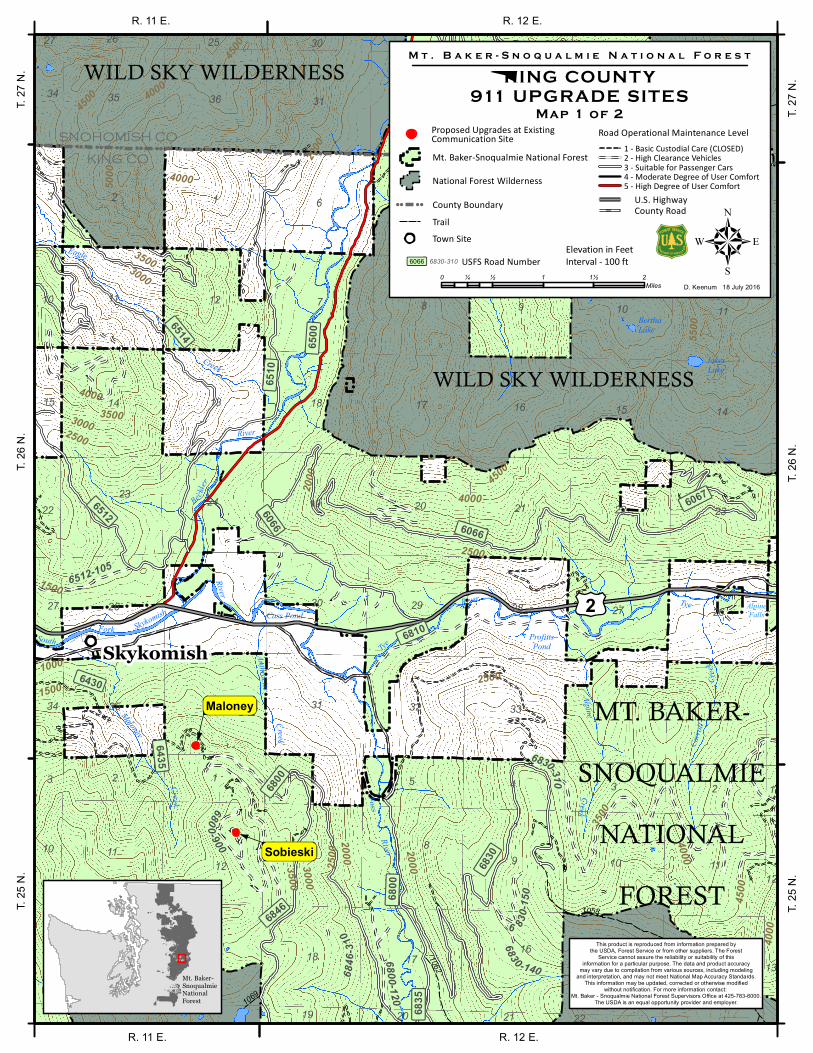
This product is reproduced from information prepared bythe USDA, Forest Service or from other suppliers. The Forest
Service cannot assure the reliability or suitability of thisinformation for a particular purpose. The data and product accuracy
may vary due to compilation from various sources, including modelingand interpretation, and may not meet National Map Accuracy Standards.
This information may be updated, corrected or otherwise modifiedwithout notification. For more information contact:
Mt. Baker - Snoqualmie National Forest Supervisors Office at 425-783-6000.The USDA is an equal opportunity provider and employer.
£¤2
MT. BAKER-SNOQUALMIE
NATIONALFOREST
0 ½ 1 1½ 2¼Miles5
D. Keenum 18 July 2016
M t . B a k e r - S n o q u a l m i e N a t i o n a l F o r e s t
KING COUNT Y911 UPGRADE SITES
&
Road Operational Maintenance Level
County RoadU.S. Highway
ßÀ6514ßÀ6430
WILD SKY WILDERNESS
SNOHOMISH CO
KING CO
Mt. Baker-SnoqualmieNationalForest
Elevation in FeetInterval - 100 ft
WILD SKY WILDERNESS
Maloney
Sobieski
Map 1 of 2
5 - High Degree of User Comfort 4 - Moderate Degree of User Comfort
1 - Basic Custodial Care (CLOSED) 2 - High Clearance Vehicles 3 - Suitable for Passenger Cars
!
!
! ! National Forest Wilderness
!
!
!
! Mt. Baker-Snoqualmie National Forest
Trail! !! ! County Boundary
&' Town Site
ßÀ6830
USFS Road Number6830-310ßÀ6066
Proposed Upgrades at ExistingCommunication Site

! ! !
!!
!!
!
! ! ! !
!
!
!!
!!
!!!!!
!!
!!
!
! ! ! ! !
!!
!!
!
!!!!!!!
!!
!!
!!!
!
!!
!
!
!
!
!
!
!
!
!
!!!
!!
!
!
!
!
!!
!
!
!
!
!
!
!
!
!!
!
!
!
!
!
!
!!!
!
!
!!
!!
!
!
!
!
!!
!!
!
!
!
!
!
!!
!
!
!
!
! !
!
!
!
!
!
!
!
!!
!!
!!!!!
!!
!!
!
!!!!!
!!
!!
!
!!!!!
!
!!
!
!
!!
!!
!
! ! ! ! !
!!
!!
!
!!
!!
! !
!
!
! ! ! !
!
!
!
!!!
!!
!
!!!!!!!
!!
!
!
!
!
!
!
!!
!
!!!
!
!
!
!
!!!
!!!!!
!!
!
!!!!
!
!!
!!
!
!
!!
!!
!
!!!
!
!!!!!!!
!
!
!!
!!
!
!
!
!
!
!!
! ! !
!
!
!
!
!!
!
!
!
!
!
!!
!
! ! !!
!
!
!
!
!
!
!
!
!
!!
!!
!!
!!
!!
!!
!
!!!
!!
!!!
!!
!!
!
! ! !!
!
! !
!!
!!
!!
!!
!!!!
!
! !
!!
!!
!
!!
!!
!!
!
!!!!!!!
!
!!
!
!
!
!
!
!
!
!
!
!
!
!
!
!
!
!!
!
!
!
!
!
!
!
!
!
!
!
!
!
!
!
!
!
!
!! !
!
!
!
!
!!
!
!
!
!
!
!
!
!!
!
!
!
!
!!
! !
!
!!
!
!
!
!
!
!
!
!
!
! ! !
!!
!!!
!!
!
!
!!
!
!
!
!!
!
!!
!
!!
!
!
!!
!
!
!
!
!
!
!
!
!!
!
!
!
!
!
!
!!
!!
! ! ! !
!!
!
!!
!
!
!!!
!!
!
!
!
!
!
!
!
!!
!
!
!
!
!
!
!
!
!
!
!
! !
!
!
!
!
!
!
!
! ! ! ! !! !
! ! !!
!
!!
!!
!
!
!
! !
!
!!
! ! !
!
!
!
! !
!
!
!
!!
!!
!!!
!!
!
!!
!
!
!
!!!
!!
!!
!
!
!
!
!
!
!
!!
!!
!
!
!!!
!
!
!
!!!!
!
!
!!
!!
!!
!
!!!
!
!
!
!
!
!
!
!!
!
!
!
!
!
!
!
!!
!
!
! !
! ! !
!
!
!! !
!
!
!
!
!
!!
!
!!
! !
!!
!
!
!
!
!!
!
!!
!
!
!
!!
!
!
!!
!!!!!
!!
!!
!
!!!!!
!!
!!
!
!!!!!
!
!
!
! !
!
!
!
!! !
!
!
!
!
!
!!
!
!
! ! !
!!
!!
!
!!
! ! ! ! !
!!
!!
!
! ! ! ! !
!!
!!
!
!!!!!
!!
!!
!
! ! !!
!!
!
!!!
! !
!
!
!
!
!
!!
!!
!!!!!!!
!!
!
!!!!
!!
!!
!!
! !
!
! !
!
!
!!
! !!!!!!
!
!!
!
! ! !
!!
!!
!
!!
! !!
!
! ! !
! !
!!
!
!!!!!
!!
! ! !
!
!
!! !
!
!!!!
!!
!
!!
!!!!
! ! !
!
!!
!
! !
!
!
!
!!
!
!!
!!
!!
!
!!
! !
!!
!
!
!
!!
!
! ! !
!
!!
!
!!!
!
!
!
!
!
!
!
!
!
!
!
!
!
! !
!
!
!
!
!
!
CREST
PACI
FICCR
EST
NATIO
NAL
SCEN
IC
TRAIL
NATION A L
&'
GravelLake
Alaska Lake
Kendall PeakLakes
Silver Creek
Gold
WolfeCreek
Resort CreekPond
Col d
Burnboot Cre ek
Goat
Creek
Pratt River
SOUTH FORK SNOQUALMIE RIVER
Hyak Cre ek
Tunnel Creek
SO UTH FORK
SNOQ U A LMIERIV
ER
Mill Creek
Gold
Creek
Creek
LakeCaroline
Hump
back
Twin Lakes
KEECHELUS LAKE
DerrickLake
UpperWildcat Lake
LowerWildcat Lake
GemLake
Chair PeakLake
FrozenLake
KaleetanLake
UpperMelakwa Lake
MelakwaLakeMy
Lake
SourceLake
LowerTuscohatchie Lake
TuscohatchieLake
DennyLake
CadLakeCrystal
Lake
LodgeLake
DivideLake
SurveyorsLake
RockdaleLake
HyakLake
MardeeLake
Rock
Creek
Thun
der
Creek
1003.4
1013.2
1007
1344
1021
1250
1036
1010
1 023
1030
1314
1012
1033
1007
1010
1011
1016
1019
1013
1013.3
1014
1003
15
10
1413
26
11
23 1
12
2322
25
15
8
35
27 26
23 24
7
17 16
1110
3433
9
19
18 14
32
13
36
12
31
292830 25
20 21 22
26
23
14
11 12
24
13
10
3534 36
2527
22
15
5
17
8
18
4
13
24
11
2
31 32
30
19
14
35
26
23
15
6
34
16
20
27
22
7
33
29 28
9
3 1
36
12
21
10
9070-110
9000
-220
9090-01
0
ßÀ9035
ßÀ9050
ßÀ9034
ßÀ9090
ßÀ5590
ßÀ9040
ßÀ4832
ßÀ5500
ßÀ9070ßÀ5800
R. 10 E. R. 11 E.
R. 10 E. R. 11 E.T.
22 N
.T.
23 N
.
T. 22
N.
T. 23
N.
This product is reproduced from information prepared bythe USDA, Forest Service or from other suppliers. The Forest
Service cannot assure the reliability or suitability of thisinformation for a particular purpose. The data and product accuracy
may vary due to compilation from various sources, including modelingand interpretation, and may not meet National Map Accuracy Standards.
This information may be updated, corrected or otherwise modifiedwithout notification. For more information contact:
Mt. Baker - Snoqualmie National Forest Supervisors Office at 425-783-6000.The USDA is an equal opportunity provider and employer.
SNOQUALMIEPASS
0 ½ 1 1½ 2¼Miles5
D. Keenum 18 July 2016
M t . B a k e r - S n o q u a l m i e N a t i o n a l F o r e s t
KING COUNT Y911 UPGRADE SITES
&
Road Operational Maintenance Level
County RoadU.S. Highway
WENATCHEENATIONAL FOREST
KING CO
KITTITAS CO
Mt. Baker-SnoqualmieNationalForest
Elevation in FeetInterval - 100 ft
ALPINE LAKESWILDERNESS
Dodge Ridge
Map 2 of 2
5 - High Degree of User Comfort 4 - Moderate Degree of User Comfort
1 - Basic Custodial Care (CLOSED) 2 - High Clearance Vehicles 3 - Suitable for Passenger Cars
!
!
! ! National Forest Wilderness
!
!
!
! Mt. Baker-Snoqualmie National Forest
Trail! !! ! County Boundary
&' Town SiteUSFS Road Number6830-310ßÀ6066
MT. BAKER- SNOQUALMIE
NATIONAL FOREST
Proposed Upgrades at ExistingCommunication Site
§̈¦90