Institute of Remote Sensing Methods for Geology (NIIKAM ... · 1 Modern sedimentation processes...
16
1 Modern sedimentation processes within the coastal zone of the Kurortny District of St.Petersburg (eastern Gulf of Finland) Daria Ryabchuk, Elena Nesterova, Mikhail Spiridonov, Leontina Sukhacheva, Vladimir Zhamoida Rуabchuk, D., Nesterova, E., Spiridonov, M., Sukhacheva, L., Zhamoida V., 2007. Modern sedimentation processes within the coastal zone of the Kurortny District of St.Petersburg (eastern Gulf of Finland). Baltica, Vol.20 (1-2), 5-12. Vilnus. ISSN 3067-3064. Abstract. As a result of investigation carried out in 2005-2006 in the northern coastal zone of the Russian part of the Gulf of Finland the new data on geological history and modern sedimentation processes have been obtained. For the first time the side-scan-mosaic scheme of investigated area was developed. Side-scan sonar data analysis permits to distinguish some important features of the bottom structure such as glacial till ridges, dynamic sands (with ripples on the surface) zones, sand waves, erosion margins (valleys), technogenic relief and objects. Keywords: eastern Gulf of Finland, coastal zone dynamics, bottom relief Daria Ryabchuk [[email protected]]; Elena Nesterova; Mikhail Spiridonov; Vladimir Zhamoida, A.P.Karpinsky Russian Research Geological Institute (VSEGEI), 74 Sredny prospect, 199106, St.Petersburg, Russia; Leontina Sukhacheva, Institute of Remote Sensing Methods for Geology (NIIKAM). Laboratory of Coastal zone research. Birzhevoy pr.6, 199034, St.Petersburg, Russia. Manuscript submitted 4 April 2007; accepted INTRODUCTION Kurortny District of St.Petersburg is located along the northern coast of the Gulf of Finland to the west of St.Petersburg Flood Protective Dam (Fig.1). It has a special importance as a unique recreation zone of the North-West of Russia. Sandy beaches and comfort climate caused the construction of many sanatoria, hotels and entertainment centers. Two protected natural territories – sandy beach with dunes in Komarovo village and oak park “Dubki” founded by Peter I – are situated here. The coastal erosion is one of the most urgent problems in this area.
Transcript of Institute of Remote Sensing Methods for Geology (NIIKAM ... · 1 Modern sedimentation processes...
1
Modern sedimentation processes within the coastal zone of the Kurortny District
of St.Petersburg (eastern Gulf of Finland)
Daria Ryabchuk, Elena Nesterova, Mikhail Spiridonov, Leontina Sukhacheva, Vladimir
Zhamoida
Rуabchuk, D., Nesterova, E., Spiridonov, M., Sukhacheva, L., Zhamoida V., 2007. Modern
sedimentation processes within the coastal zone of the Kurortny District of St.Petersburg (eastern
Gulf of Finland). Baltica, Vol.20 (1-2), 5-12. Vilnus. ISSN 3067-3064.
Abstract. As a result of investigation carried out in 2005-2006 in the northern coastal zone of
the Russian part of the Gulf of Finland the new data on geological history and modern
sedimentation processes have been obtained. For the first time the side-scan-mosaic scheme of
investigated area was developed. Side-scan sonar data analysis permits to distinguish some
important features of the bottom structure such as glacial till ridges, dynamic sands (with ripples
on the surface) zones, sand waves, erosion margins (valleys), technogenic relief and objects.
Keywords: eastern Gulf of Finland, coastal zone dynamics, bottom relief
Daria Ryabchuk [[email protected]]; Elena Nesterova; Mikhail Spiridonov; Vladimir
Zhamoida, A.P.Karpinsky Russian Research Geological Institute (VSEGEI), 74 Sredny prospect,
199106, St.Petersburg, Russia; Leontina Sukhacheva, Institute of Remote Sensing Methods for
Geology (NIIKAM). Laboratory of Coastal zone research. Birzhevoy pr.6, 199034, St.Petersburg, Russia.
Manuscript submitted 4 April 2007; accepted
INTRODUCTION
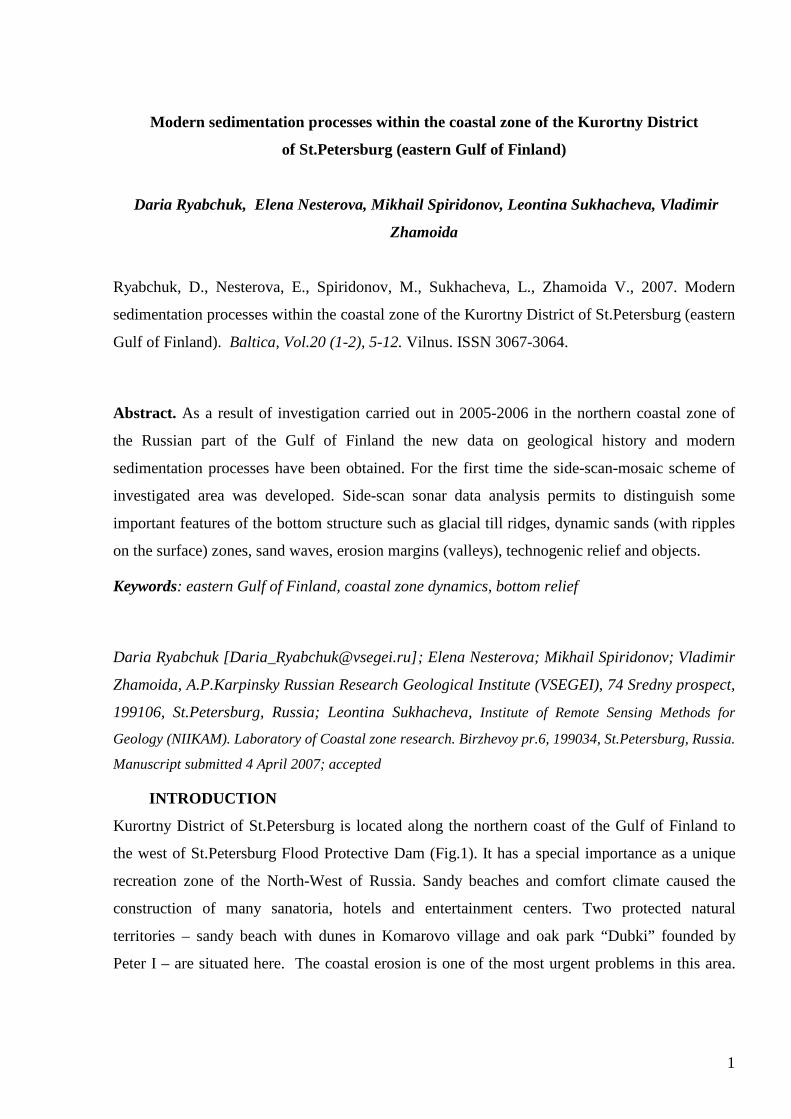
Kurortny District of St.Petersburg is located along the northern coast of the Gulf of Finland to
the west of St.Petersburg Flood Protective Dam (Fig.1). It has a special importance as a unique
recreation zone of the North-West of Russia. Sandy beaches and comfort climate caused the
construction of many sanatoria, hotels and entertainment centers. Two protected natural
territories – sandy beach with dunes in Komarovo village and oak park “Dubki” founded by
Peter I – are situated here. The coastal erosion is one of the most urgent problems in this area.
2
Clear understanding of the recent coastal development, that is the main objective of the study, is
extremely needed for elaboration of the coast protective measurements.
Fig.1. Investigated area.
Investigated coastal zone – which includes both shore and nearshore areas - has some
special features of geological structure and history. It is situated in the transitional zone of the
Baltic Shield and the Russian Plate. Pre-Quaternary rocks are represented mainly by Vend
terrigenous deposits and migmatite garnet-biotite gneisses displaying in erosive palaeo-valleys
100–115 meters deep. These rocks are totally covered by Quaternary deposits up to 20-40 meters
thick (Spiridonov & Pitulko 2002). The history of the Baltic Sea water basin development in the
late Pleistocene – Holocene as a whole is accepted by geological society (Raukas & Hyvarinen
1992). The main features of the recent coastal zone were formed during degradation of the last
glacial cover and essentially transformed during post-glacial period characterized by the
alteration of marine, continental and lake conditions. In spite of this fact many details of the
eastern Gulf of Finland geological history such as migration of ancient coastal lines (especially
below the modern sea level) are still debatable.
As it is well-known, after the Weichselian ice sheet melting the local glacial lakes were
formed in the investigated area. About 12 000 years ago they united in the Baltic Ice Lake
(Raukas & Hyvarinen 1992; Spiridonov et al. 1988). The most wide spread type of distal facies
of the lacustrine-glacial deposits consists of varved clays (local ice lakes), laminated and
The Gulf of Finland
A.Amantov, 2005
3
homogenous brownish-grey clays (Baltic Ice Lake). In the investigated area these sediments
don’t differ from their analogues in the other parts of the gulf bottom. On the contrary Holocene
sediments (Ancylus and Yoldia stages, Litorina and Limnea seas) are represented mainly by
sands of near-shore facies. According to former VSEGEI submarine drilling data the thickness of
Holocene sands in some sampling sites achieves 1.50–1.60 meters. These data are partly
corresponded to the palaeo-reconstructions of the Holocene coastal lines (Raukas & Hyvarinen
1992; Raukas 1994).
Nowadays the coastal zone of the eastern Gulf of Finland is characterized by a specific
regime of litho- and morphodynamics caused by sharp periodic fluctuations of the sea level,
seasonal ice-forming processes, intensive and various anthropogenic activities. As a result the
investigated coastal zone is characterized by very complicated (“mosaic”) distribution of the
sediments and specific geomorphological features. It is possible to observe the alteration of the
erosion and accumulation zones, different forms of dynamic accumulation, longshore sand drift,
aeolian transformation, etc.
MATERIALS AND METHODS
Since 1981 the Department of Regional Geoecology and Marine Geology of Russian Research
Geological Institute (VSEGEI) has carried out complex studies for State geological mapping and
geoenvironmental investigations in the eastern Gulf of Finland. As a result of these works the set
of geological maps of the sea-bed (maps of bedrock, Quaternary sediments, superficial
sediments, etc.) was compiled at 1:200 000 scale (Spiridonov & Zhamoida 2004; Zhamoida et
all. 2006). Since 2000 a special attention has been paid to the coastal zone dynamics processes.
In 2005-2006 VSEGEI and Institute of Remote Sensing Data for Geology (NIIKAM) with the
financial support of “Morzashita” (Department of St.Petersburg Government) fulfilled
multipurpose investigations of the northern coastal zone of the eastern Gulf of Finland (between
capes Lautaranta and Dubovskoy) (Fig.1). The study included the on-land field observations,
depth measuring, sediment sampling of the beaches and near-shore sea bottom. The side-scan
sonar profiling accompanied by bottom sediment sampling (box-corer and Lauri-Niemisto
gravity-corer) was mostly effective and useful method for investigation of the bottom relief and
distribution of the superficial sediments as well as the study of technogenic objects. During two
years more than 400 km of side-scan survey (including 100 km of repeated profiling) were
carried out in the near-shore zone (water depths 2–10 meters). The range of side-scan (CM-2 C-
MAX.Ltd) was about 100 meters, acoustic frequency 102 kHz. The distance between profiles
4
(186 meters) permits to receive continuous acoustic picture of all investigated sea bottom area.
Repeated survey of three parts of near-shore zone (in front of villages Komarovo, Repino and
Solnechnoye) allowed studying development of the bottom relief and sediment distribution.
RESULTS AND INTRERPRETATION
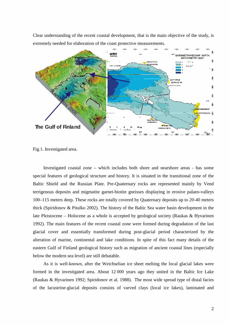
The investigated part of the coasts of the gulf from Zelenogorsk to the Dam can be subdivided
into five subtypes – moraine erosion (34% of investigated coastal zone extension), stable with
periodic erosion of sandy beach (25%), sand accretion or silty-clay accumulative (38%) and
technogenic (artificial) (less that 3%) (Fig.2). The waves and along-shore currents are the most
important factors controlling the litho-dynamics processes. The highest waves affected the coast
are observed during western and southwestern wind direction.
Fig.2. Map of the coastal
zone subtypes distribution
(Kurort District, northern
coastal zone of the Gulf of
Finland).
Each type of the coastal zone has its typical features. In erosion zone as a result of intensive
sand drift in the eastern direction and sediment starvation a boulder-pebble bench is being
formed both at the beach and near-shore zone. The upper part of the shoreface profile of this type
5
55
5
10
5
10
10
5
5
60 10
29 50
29 50
29 4
0
0
29 58.2 0
0
0
60 11.55 0
0
60 05 0
0
60 10 0
60 11.55 0
29 4
0 0
0
29 58.2 0
60 05 0
60 01,450 60 01,450
Legend:
- moraine erosion
- stable with periodic erosion of sandy beach
- sand accretion
- mud accumulative with water plants at the nearshore zone
- technogenic
Coastal zone subtypes:Coasts alighning with erosion and accretion processes:
- sand accretion
Coasts alighned with accretion processes:
Developed by D.Ryabchuk,E.Nesterova, G,Suslov et al.
0.00 5.00 10.00Scale in Kilometers
cape Tarkala
cape Dubovskoy
Sestroretsk
Solnechnoye
Repino
KomarovoZelenogorsk

5
is represented by a gently descending boulder-cobble bench sometimes with irregular sand spots
which are not exibited in bottom relief (Fig.3).
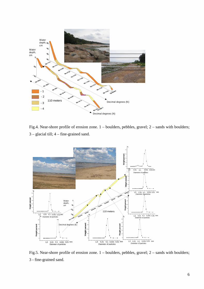
Fig.3. Near-shore profile of erosion zone. 1 – boulders, pebbles, gravel; 2 – sands with boulders;
3 – glacial till; 4 – fine-grained sand.
At the straight coast sections with narrow sandy beaches, coastal line is more or less stable,
but during storm periods erosion processes take place here as well. During sea level rise
accompanied by storm waves sand beaches are washed out there. The coastal slope profile is
characterized by a well developed longshore sand bars at the boulder-pebble bench surface
(Fig.4).
Within the areas of sand accretion which are situated to the east of Solnechnoye village,
where coastal line changes its direction from longitudinal to latitudinal – sandy beach is as wide
as 100 meters. In the near-shore zone both sand ridges and runnels between them are formed by
fine grained sand (Fig.5).
The measurements of the coastal slope depths have shown that the bathymetry profiles in
the near-coastal zone are very much changeable and depend on hydro meteorological factors.
The bathymetric profiles of the down part of the coastal slope (3–10 meters water depth) are
much more stable.
- 1
- 2
- 3
- 4
110 meters
Water depth, cm
Decimal degrees (N)
Water depth, cm
Decimal degrees (N)
6
Fig.4. Near-shore profile of erosion zone. 1 – boulders, pebbles, gravel; 2 – sands with boulders;
3 – glacial till; 4 – fine-grained sand.
110 meters
Water depth, cm
Decimal degrees (E)
0
10
20
30
40
mm0,010,0310,10,311,0
%
Diameter of particles
0
10
20
30
40
mm0,010,0310,10,311,0
%
Diameter of particles
0
10
20
30
40
50
mm0,010,0310,10,311,0
%
Diameter of particles
0
10
20
30
40
50
mm0,010,0310,10,311,0
%
Diameter of particles
0
10
20
30
40
50
mm0,010,0310,10,311,0
%
Diameter of particles
0
10
20
30
40
mm0,010,0310,10,311,0
%
Diameter of particles
0
10
20
30
40
50
mm0,010,0310,10,311,0
%
Diameter of particles
Fig.5. Near-shore profile of erosion zone. 1 – boulders, pebbles, gravel; 2 – sands with boulders;
3 - fine-grained sand.
- 1
- 2
- 3
- 4
110 meters
Water depth, cm
Decimal degrees (N)
Water depth, cm
Decimal degrees (N)

7
For submarine part of the coastal zone the main features of the sea-bottom relief and
distribution of the bottom sediments were recognized, and detailed sea-bed map (scale 1:50 000)
of studied area was developed. The coarse-grained sediments (boulders, pebbles, sands with
gravel) are spread in the areas of submarine erosion of glacial till. It is possible to distinguish
five different types of sands formed by modern erosion and accumulative processes caused by
wave and current activity, and some relict sandy forms. Modern silty-clay mud is accumulated
within the sea depths more than 10 meters (Fig.6).
Fig.6. Map of the bottom
sediments (near-shore of the
Kurort District).
1 – sands with gravel; 2 – sands
with gravel and boulders; 3 –
sands with boulders; 4 –
unsorted sands; 5 – coarse to
medium sands; 6 – medium to
fine sands; 7 – fine sands; 8 –
silty sands; 9 – clayey silts; 10
– silty-clay mud; 11 –
technogenic sediments
(dumping place); 12 – sand
ridges; 13 – erosion valleys; 14
– technogenically transformed
relief; 15 – fairways; 16 – crib-
bars; 17 – areas of high
accumulation; 18 – crib-bars,
covered with sediments; 19 –
sunken vessels.
Study of the modern silty-clay mud accumulation zone has shown that the modern mud
thickness has not been increasing in investigated area during the last 10-15 years. In the marginal
zones of mud accumulative area modern sediments thickness has not changed, in the central part
of sedimentation basin the silty clay mud thickness has decreased during last 15 years and in
some sediment cores the sandy layers have been observed. These facts allow to suppose weak
5
Zelenogorsk
Komarovo
Repino
Solnechnoye
Sestroretsk
cape Tarkala
Cape Dubobskoy
60 0060 00
60 10
29 50
29 50
29 4
0
0
0
0
0
60 050
29 4
00
60 050
60 100
- 1- 2- 3- 4- 5
- 6- 7- 8- 9
- 10- 11- 12- 13- 14
- 15- 16- 17- 18- 19
Developed by: M.Spiridonov,D.Ryabchuk, S.Manuylov et al.
8
erosion processes within this area. Modern sediment cores indicate a frequent changing of both
sedimentological and geochemical environments.
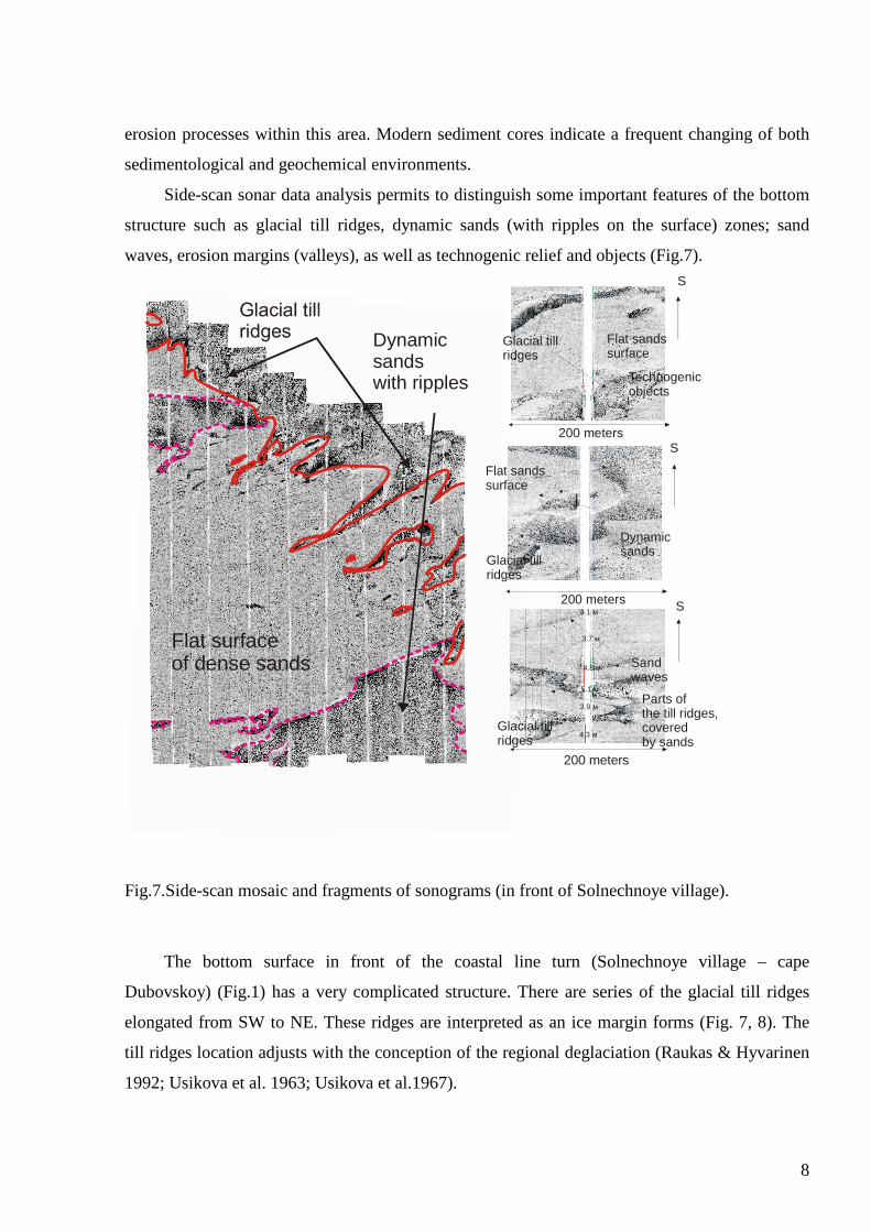
Side-scan sonar data analysis permits to distinguish some important features of the bottom
structure such as glacial till ridges, dynamic sands (with ripples on the surface) zones; sand
waves, erosion margins (valleys), as well as technogenic relief and objects (Fig.7).
Fig.7.Side-scan mosaic and fragments of sonograms (in front of Solnechnoye village).
The bottom surface in front of the coastal line turn (Solnechnoye village – cape
Dubovskoy) (Fig.1) has a very complicated structure. There are series of the glacial till ridges
elongated from SW to NE. These ridges are interpreted as an ice margin forms (Fig. 7, 8). The
till ridges location adjusts with the conception of the regional deglaciation (Raukas & Hyvarinen
1992; Usikova et al. 1963; Usikova et al.1967).
Dynamicsandswith ripples
Flat surfaceof dense sands
200 м
Dynamicsands
200 meters
S
Glacial tillridges
Flat sandssurface
Technogenicobjects
200 meters
200 meters
Sandwaves
Parts of the till ridgescoveredby sands
,
3.9 м
4.3 м
5.1 м
4.8 м
3.7 м
4.1 м
S
S
Flat sandssurface
Glacial tillridges
Glacial tillridges
9
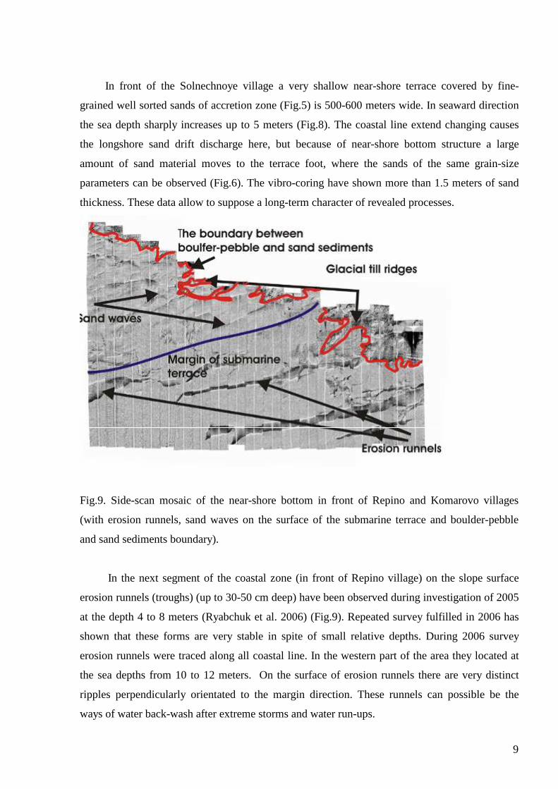
In front of the Solnechnoye village a very shallow near-shore terrace covered by fine-
grained well sorted sands of accretion zone (Fig.5) is 500-600 meters wide. In seaward direction
the sea depth sharply increases up to 5 meters (Fig.8). The coastal line extend changing causes
the longshore sand drift discharge here, but because of near-shore bottom structure a large
amount of sand material moves to the terrace foot, where the sands of the same grain-size
parameters can be observed (Fig.6). The vibro-coring have shown more than 1.5 meters of sand
thickness. These data allow to suppose a long-term character of revealed processes.
Fig.9. Side-scan mosaic of the near-shore bottom in front of Repino and Komarovo villages
(with erosion runnels, sand waves on the surface of the submarine terrace and boulder-pebble
and sand sediments boundary).
In the next segment of the coastal zone (in front of Repino village) on the slope surface
erosion runnels (troughs) (up to 30-50 cm deep) have been observed during investigation of 2005
at the depth 4 to 8 meters (Ryabchuk et al. 2006) (Fig.9). Repeated survey fulfilled in 2006 has
shown that these forms are very stable in spite of small relative depths. During 2006 survey
erosion runnels were traced along all coastal line. In the western part of the area they located at
the sea depths from 10 to 12 meters. On the surface of erosion runnels there are very distinct
ripples perpendicularly orientated to the margin direction. These runnels can possible be the
ways of water back-wash after extreme storms and water run-ups.
10
On the coastal slope in front of Zelenogorsk and Komarovo villages the system of sand
ridges (sand waves) and runnels within the sea depth from 3 to 5 meters was traced (Fig.9). An
important feature of sand waves is their elongation with the angle of 40-50 degrees to the coastal
line in contrast to the longshore bars located in first 200-500 meters from the shore. Alongshore
bar system is very good visible at the satellite pictures. New data analysis permits to establish
that sand waves are situated on the submarine terrace surface which locates at the sea depths
about 4 meters (Fig.10). The terrace is up to 2.5 km wide and 17 km long, its foot is located at
the sea depths of 8-9 meters. It is formed by medium- to coarse grained sand.
DISCUSSION
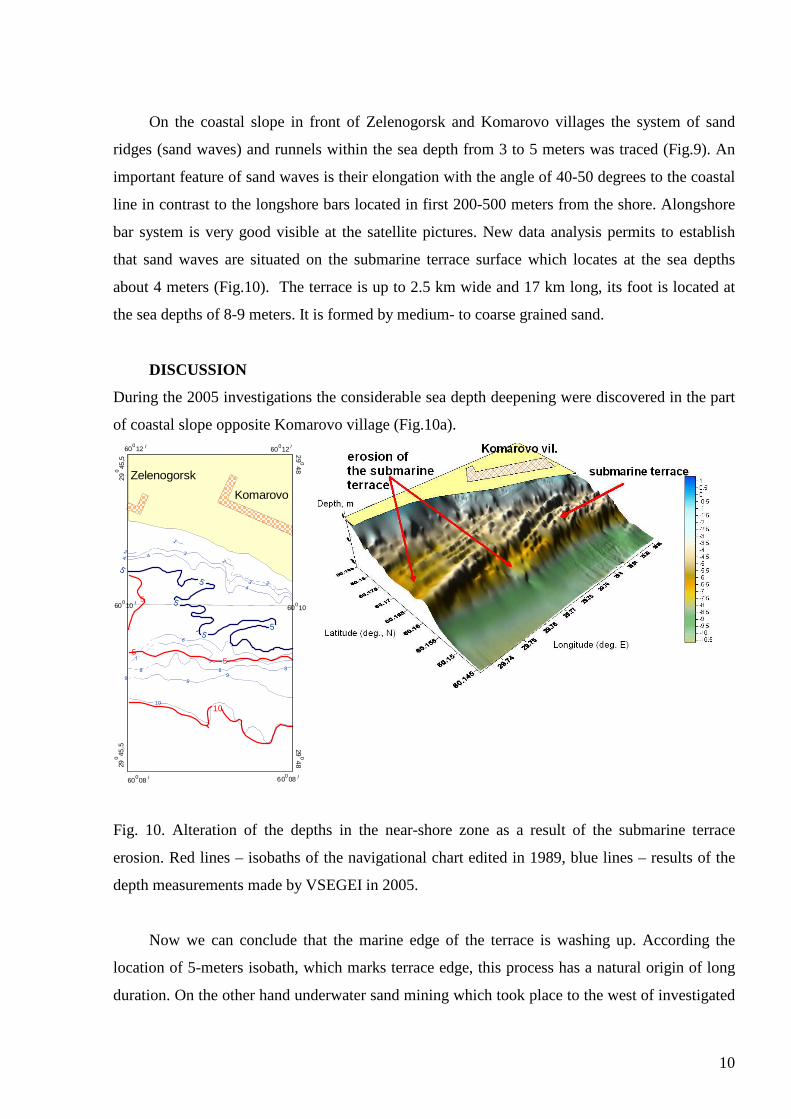
During the 2005 investigations the considerable sea depth deepening were discovered in the part
of coastal slope opposite Komarovo village (Fig.10a).
Fig. 10. Alteration of the depths in the near-shore zone as a result of the submarine terrace
erosion. Red lines – isobaths of the navigational chart edited in 1989, blue lines – results of the
depth measurements made by VSEGEI in 2005.
Now we can conclude that the marine edge of the terrace is washing up. According the
location of 5-meters isobath, which marks terrace edge, this process has a natural origin of long
duration. On the other hand underwater sand mining which took place to the west of investigated
5
10
5
5
Zelenogorsk
Komarovo
60 100 /60 100 /
29
45,5
29
480
0
60 120 /
60 080 /
60 080 /
60 120 /
29 480
29 4
5,5
0
34
24
5
1
2
34
5 2
9
8
7
99
8
7
6
5
5
8
5
10

11
area in 1969-1992 can be supposed as one of the possible reasons of this process intensification.
About 140-160 millions m3 of sand were excavated from this area. The sand were mined within
the submarine terrace of Litorina Sea situated at the sea depth 6-12 meters, but because of the
violation of technology the sands of nearshore zone were affected as well (Moskalenko et al.
2004).
The question of the submarine terrace age and genesis are not clear yet. It should be
mentioned that the Pleistocene and Holocene ancient coastal line location on the mainland of the
northern coast of the Gulf is well known (Auslender et al. 2002) as well as submarine ancient
coastal line positions for many regions of the Baltic Sea (Boldyrev & Blazhchishin, 1982;
Uscinowicz 2003). In the same time such investigations have not been done for the shorelines
existed during the Holocene regressions in the eastern Gulf of Finland.
According to the modern conception (Dolotov et al. 2001) such big accumulative bodies
can be formed during slow relative decreasing of the sea water level and uninterrupted
sedimentation with enough sand material quantity on the smooth coastal slope. It should be
mentioned that to the west of investigated area (between capes Flotsky and Peschany) there is
another submarine terrace with the surface situated at the sea depths 8-12 meters. During pre-
exploration works with the sand prospect drilling made here by VSEGEI in 1982 and 1992, the
hypothesis of the terrace formation during early Holocene sea regression was advanced.
Unfortunately, there were no enough geological data for such a preposition. Besides, the terrace
can be partly washed out during subsequent sea level rising.
The other possible assumption of the submarine terrace formation in front of Zelenogorsk –
Komarovo village is corresponded to V.Zenkovitch (1962) scheme. In accordance with it the
sand accumulative body is usually formed near the marine edge of the bench during erosion
processes. In such a case the mentioned terrace could be formed during the maximum of Litorina
transgression when the sea level was about 6 meters higher, so the water depth above the terrace
surface was about 10 meters (Auslender et al. 2002). The cliffs up to 40 meters high were
worked out at that time in glacio-fluvial sandy os relief forms. But both hypothesis don’t explain
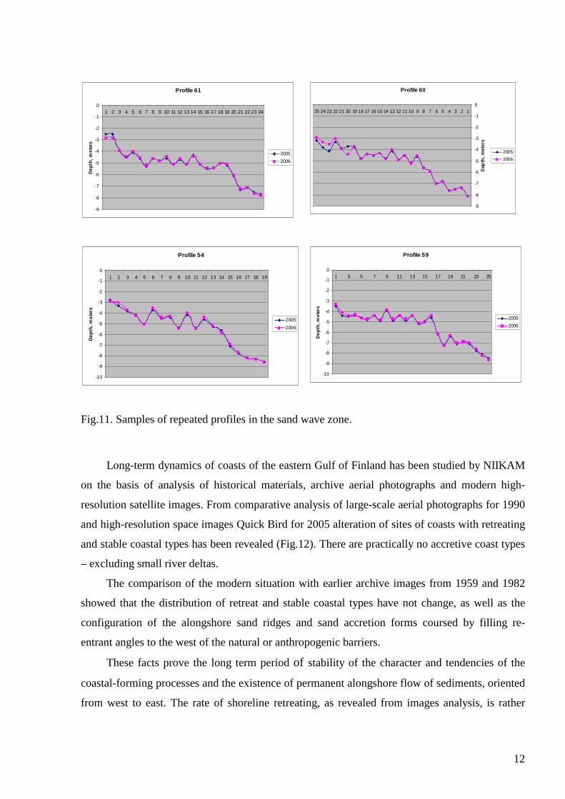
the sand ridges formation which are not parallel neither modern nor ancient shorelines. Repeated
survey has shown (Fig.11) that sand waves are rather stable. So it is possible to assume their
dynamic equilibrium and inconformity to the modern hydro dynamics processes.
12
Fig.11. Samples of repeated profiles in the sand wave zone.
Long-term dynamics of coasts of the eastern Gulf of Finland has been studied by NIIKAM
on the basis of analysis of historical materials, archive aerial photographs and modern high-
resolution satellite images. From comparative analysis of large-scale aerial photographs for 1990
and high-resolution space images Quick Bird for 2005 alteration of sites of coasts with retreating
and stable coastal types has been revealed (Fig.12). There are practically no accretive coast types
– excluding small river deltas.
The comparison of the modern situation with earlier archive images from 1959 and 1982
showed that the distribution of retreat and stable coastal types have not change, as well as the
configuration of the alongshore sand ridges and sand accretion forms coursed by filling re-
entrant angles to the west of the natural or anthropogenic barriers.
These facts prove the long term period of stability of the character and tendencies of the
coastal-forming processes and the existence of permanent alongshore flow of sediments, oriented
from west to east. The rate of shoreline retreating, as revealed from images analysis, is rather
Profile 61
-9
-8
-7
-6
-5
-4
-3
-2
-1
01 2 3 4 5 6 7 8 9 10 11 12 13 14 15 16 17 18 19 20 21 22 23 24
De
pth
, m
ete
rs
2005
2006
Profile 60
-9
-8
-7
-6
-5
-4
-3
-2
-1
012345678910111213141516171819202122232425
Dep
th,
met
ers
2005
2006
Profile 54
-10
-9
-8
-7
-6
-5
-4
-3
-2
-1
01 2 3 4 5 6 7 8 9 10 11 12 13 14 15 16 17 18 19
Dep
th,
me
ters
2005
2006
Profile 59
-10
-9
-8
-7
-6
-5
-4
-3
-2
-1
01 3 5 7 9 11 13 15 17 19 21 23 25
De
pth
, m
ete
rs2005
2006

13
insignificant – the average value is about 0.5 m/year, maximal - up to 2 m/year (at the beach of
settlement Solnechnoye).
Fig.12. Coastal zone dynamics of Kurortny
Districte of St. Petersburg revealed from
analysis of the large-scale aerial photographs
from 1990 and satellite Quick Bird images
from 2005 (for areas Smolyachkovo-
Zelenogorsk and Zelenogorsk – Sestroretsk.
But from the point of view of high recreation value of the beaches – it can be dangerous in
any case. One of the important results of conducted investigations is the conclusion that the
system of constructions for coastal protection is not effective and continuously destroying by
waves.
The autumn storms rework even the widest beaches (100-140 meters) in Solnechnoye and
Zelenogorsk. Progressive washing up of the dunes along the Protected Natural Area in
Komarovo is the most hazardous process (Pogrebov & Sagitov 2006).
The most intensive beaches destruction was observed in Komarovo village after the storm
and flooding in 11 of January, 2007. In contrast to the eastern part of the investigated coastal
zone, there was no ice here yet. In such a case the ice could protect beaches against the washing
up.
14
The beaches conditions are very threatened and the destruction of the submarine terrace
margin – which can intensify the processes - is hazardous for the coast.
CONCLUSIONS
Within the investigated part of the coastal zone of the gulf from Zelenogorsk to Solnechnoye
village which is characterized by latitudinal coastal line extension the erosion processes
dominate. The deposits at the shore and coastal slope of the capes are represented by boulders
and pebbles as a result of glacial till erosion. At the relatively straight parts of the coast in the
area of Komarovo and Repino villages erosion of sandy beaches occurs. The sediment drift in
the form of underwater sandy ridges has an eastern direction.
In the area of Solnechnoye village the coast line turns to the south that forms conditions
favorable for sand accumulation at the coast and coastal slope. But sandy accretion and beach
growing does not occur due to narrow (500-600 meters width) shallow near-shore terrace. The
main part of incoming sediments follows to the terrace foot.
On the coastal slope in front of Zelenogorsk and Komarovo village the terrace (2.5 km
wide and 17 km long) is located. The bottom relief of terrace is characterized by the system of
sand ridges (sand waves) within the sea depth from 3 to 5 meters. Repeated survey has shown
their stability. Taking into account their orientation it is possible to assume their inconformity to
the modern hydro dynamics processes. Seaward margin of terrace is actively eroded. At the foot
of terrace at the sea depths from 8 to 12 meters the erosion runnels were traced. The runnels are
served as the ways of water back-wash and sediment outflow after extreme storms and water
run-ups.
The series of the ridges, which were interpreted as ice margin forms, were fixed in front of
the coastal line turn (Solnechnoye village – cape Dubovskoy).
Acknowledgments
The authors wish to thank VSEGEI colleagues G.Suslov and S. Manuilov for their help and
fruitful comments, as well as Dr. P.Šinkūnas for his valuable review of the manuscript.
References
Auslender, V.G., Yanovsky A.S., Kabakov L.G., Pleshivtseva E.S. 2002. New facts in the
geology of St.Petersburg. Mineral, N 1 (4), 51-58. In Russian.

15
Boldyrev, V.L., Blazhchishin, A.I. 1982. Ancient shorelines and shore formations in the south-
eastern part of the Baltic Sea. Baltica, Vilnus, 57-65. In Russian, summary in English.
Dolotov, Yu.S., Zhindarev, L.A., Kaplin, P.A., Nikiforov, L.G., Lukyanova S.A., Rychagov G.I.
2001. Development of sand coasts of seas without tides under the sea level oscillation
conditions: The mankind and the coastal zone of the World Ocean in XXI century. Moscow,
GEOS, 28-40 (In Russian, summary in English)
Moskalenko, P.E., Zhamoida, V.A., Manuylov, S.F., Spiridonov, M.A 2004. The geological
structure, history of geological development and potential mineral resources of the eastern
the Gulf of Finland. Mineral resources of the Baltic Sea – exploration, exploitation and
sustainable development. Hanover, 135-145.
Pogrebov V.B., Sagitov R.A.(eds.). 2006. Nature Conservation Atlas of the Russian Part of the
Gulf of Finland. St.Petersburg, “Tuscarora”, 60 p.
Raukas, A. 1994. Yoldia stage – the least clear interval in the Baltic Sea history. Baltica, vol. 8,
5-14.
Raukas A., Hyvarinen H. (eds). 1992. Geology of the Gulf of Finland. Tallinn, 422 p.
Ryabchuk, D.V., Spiridonov, M.A., Malysheva, N.B., Manuylov, S.F., Shakchverdov V.A. 2006.
Geoenvironmental monitoring study of the coastal zone and sedimentative processes near
St.Petersburg Flood Protective Dam. Abstracts of VII International Environmental Forum
“Baltic Sea Day”. St.Petersburg, “Dialog”, 234-237.
Spiridonov M., Pitulko V. (eds.), 2002. Geoecological atlas of the eastern part of Gulf of
Finland. St.Petersburg. 50 p.
Spiridonov, M.A., Rybalko, A.E., Butylin, V.P., Spiridonova, E.A., Zhamoida, V.A.,
Moskalenko, P.E. 1988. Modern data, facts and views on the geological evolution of the
Gulf of Finland. In: B.Winterhalter (ed.), The Baltic Sea. Geological Survey of Finland
Special Paper 6, 95-100.
Spiridonov, M.A., Zhamoida, V.A. 2004. The natural and anthropogenic features of the coastal
zone of the eastern Gulf of Finland. Proceedings of the conference “Rapid transgression
into semi-enclosed basins”, May 8-10, 2003. Gdansk-Jastarnia, Poland, 71-76.
Usikova, T.V., Kleimenova, G.J., Jinoridze, R.N. 1963. The history of the Leningrad district
development in the late- and post-glacial times. Baltica, N 1, Vilnius, 150-173 (in Russian,
summary in English and German).
Usikova, T.V., Kleimenova, G.J., Jinoridze, R.N. 1967. On the question of the Baltic Sea
development in the Leningrad area during the late-glacial time. Baltica, N 3, Vilnius, 43-
16
60 (in Russian, summary in English and German).
Uscinowicz, S. 2003. Relative sea level changes, glacio-isostatic rebound and shoreline
displacement in the southern Baltic. Polish Geological Institute Special Paper, 10.
Warszawa, 80 p.
Zenkovitch, V.P., 1962. The base of the coast investigation. Moscow, USSR Academy of
Science, 710 p.
Zhamoida, V., Ryabchuk, D., Spiridonov, M., Shakhverdov V. 2006. GIS-Atlas of geological
and geoecological maps of the Russian Sector of the Baltic Sea and its coastal zone. The
Baltic Sea Geology: The Ninth Marine Geological Conference, Riga, 120-121.