Play Fairway Analysis for Geothermal Exploration in ... · Lindsey et al. 2 The United States...
15
Proceedings World Geothermal Congress 2020 Reykjavik, Iceland, April 26 – May 2, 2020 1 Play Fairway Analysis for Geothermal Exploration in Northwest Argentina: Initial Data Compilation and Review Cary R. Lindsey 1 , Gabriel Asato 2 , Virginia Naón 2 , Cintia Marquetti 2 , Raul Seggiaro 2 , Noelia Carrizo 2 , Nicolas Larcher 2 , Bridget Ayling 1 , Alejandro Conde Serra 2 , Javier Peroni 2 , Federico Carballo 2 , Manuela Elissondo 2 , Johanna Kaufman 2 , Adriana Balbi 2 , Silvia Castro Godoy 2 , Verónica Castano, Diego Azcurra 2 , Mark Coolbaugh 1 , and James Faulds 1 1 Great Basin Center for Geothermal Energy, University of Nevada, Reno, USA 2 Servicio Geológico Minero, Argentina [email protected] Keywords: Argentina, geothermal, Play Fairway, geostatistics, exploration ABSTRACT In 2017, the Great Basin Center for Geothermal Energy (GBCGE) received funding from the United States Department of State’s Bureau of Energy Resources to take the geothermal play fairway approach global under the Geothermal Development (GEODE) initiative. This initiative aims to increase the capacity of foreign governments to develop their geothermal resources via collaborative knowledge transfer and training, and deployment of innovative methods such as geothermal play fairway analysis to evaluate regional geothermal potential and reduce exploration risk. The first country selected for collaborative work under GEODE was Argentina. The collaboration in Argentina is with Servicio Geológico Minero Argentino (SEGEMAR), Argentina’s national geological survey, who are tasked with producing and housing geological, mining, and environmental information for the sustained development of Argentina’s natural resources and mitigation of geological hazards. Working with the GBCGE team, SEGEMAR geoscientists identified a target area for the project to apply and develop geothermal play fairway analysis workflows that are appropriate for the local geological setting and regional data availability. The study area is in the Salta and Jujuy Provinces of northwestern Argentina in the central Andes (Puna plateau) and is approximately 45,000 km² in area. It encompasses multiple thermal areas including the Cerro Tuzgle and Coranzulí volcanic centers as well as many geothermal areas associated with the Calama-Olacapato-Toro transverse lineament. The primary datasets identified for use in the project include: 1) spring locations and associated data such as temperature and geochemistry; 2) fault locations with additional attributes such as slip rate and fault recency; 3) earthquake data including depth and magnitude; 4) relative age of volcanism; and 5) hydrothermal alteration type and age. The team from SEGEMAR and GBCGE completed compilation of available, prioritized datasets as identified during initial meetings. The resulting maps offer insight to the geothermal potential and provide direction for future refinement, weighting, and completion of the play fairway analysis. 1. INTRODUCTION Geothermal resource evaluation has been occurring in Argentina for decades. It has been suggested that with proper development, 20% of Argentina’s electricity needs could be powered by geothermal energy (Gawell et al., 1999), and with today’s technology produce as much as 2010 MWe (Battocletti et al., 1999). In the 1950s, the Argentine government commissioned the evaluation of potential prospects, resulting in the identification of several high-interest locations spanning multiple provinces. Among these were the Tuzgle-Tocomar area, Domuyo, and Copahue. Despite the identification of potential resources, significant activity did not begin again until the 1970s when the national government, supported by the United Nations Development Program (UNDP), carried out another investigation into potential resources. Several resources were again identified and subsequently the National Commission of Geothermal Studies was created in 1974 to continue research and exploration. In 1979, the Government prepared a plan, along with the support of international cooperation programs, for the development of geothermal energy, the Geothermal Realization 1979. Pre- feasibility was assessed in several provinces but focused on three primary sites - Tuzgle-Tocomar, Copahue, and Domuyo (Bona and Coviello, 2016). In 1982, a geothermal survey project was developed by Universidad Nacional de Salta specialists covering part of the southern Puna (UNdS, 1982). In 1985, the Regional Center for Geothermal Energy of Neuquén (CREGEN) was created, and a small pilot plant of 0.67 MWe was commissioned in 1988 at Copahue. Concurrently, the feasibility study with the support of the Agency of International Cooperation of Japan (JICA) was completed. CREGEN also developed hydrogeological and geochemical studies in Tuzgle-Tocomar in Salta and Jujuy, Famatina in La Rioja, and Termas de Rio Hondo (Tucumán and Santiago del Estero) (Bona and Coviello, 2016). In 1992, the feasibility study ended at Copahue and production ceased (Mas, 2005). In December 2006, Law 26.190 established national policy to promote the use of renewable sources. The law mandated a contribution of 8% to the national electricity consumption for 2017 and an increase to 20% by 2025, and in recent years there has been an emergence of provincial initiatives to revive the geothermal electric sector (Neuquén, San Juan, Mendoza, Jujuy, and Salta) (Bona and Coviello, 2016). The current energy demand, renewable mandates, and abundance of geothermal resources in Argentina led to the current collaborative project, funded by the United States Department of State, between the Great Basin Center for Geothermal Energy, and SEGEMAR, the Servicio Geológico Minero Argentino, Argentina’s national geologic survey. The current project is styled after recent United States Department of Energy-funded Geothermal Play Fairway Analysis (PFA) projects. The term “play fairway” originates in the oil and gas industry. The objective of a PFA is to compile data that are related to resource potential, and then weight and compile those layers to identify areas that are prospective and of lower risk for future exploration.
Transcript of Play Fairway Analysis for Geothermal Exploration in ... · Lindsey et al. 2 The United States...
Proceedings World Geothermal Congress 2020
Reykjavik, Iceland, April 26 – May 2, 2020
1
Play Fairway Analysis for Geothermal Exploration in Northwest Argentina: Initial Data
Compilation and Review
Cary R. Lindsey1, Gabriel Asato2, Virginia Naón2, Cintia Marquetti2, Raul Seggiaro2, Noelia Carrizo2, Nicolas Larcher2, Bridget
Ayling1, Alejandro Conde Serra2, Javier Peroni2, Federico Carballo2, Manuela Elissondo2, Johanna Kaufman2, Adriana Balbi2,
Silvia Castro Godoy2, Verónica Castano, Diego Azcurra2, Mark Coolbaugh1, and James Faulds1
1Great Basin Center for Geothermal Energy, University of Nevada, Reno, USA
2Servicio Geológico Minero, Argentina
Keywords: Argentina, geothermal, Play Fairway, geostatistics, exploration
ABSTRACT
In 2017, the Great Basin Center for Geothermal Energy (GBCGE) received funding from the United States Department of State’s
Bureau of Energy Resources to take the geothermal play fairway approach global under the Geothermal Development (GEODE)
initiative. This initiative aims to increase the capacity of foreign governments to develop their geothermal resources via collaborative
knowledge transfer and training, and deployment of innovative methods such as geothermal play fairway analysis to evaluate regional
geothermal potential and reduce exploration risk. The first country selected for collaborative work under GEODE was Argentina.
The collaboration in Argentina is with Servicio Geológico Minero Argentino (SEGEMAR), Argentina’s national geological survey,
who are tasked with producing and housing geological, mining, and environmental information for the sustained development of
Argentina’s natural resources and mitigation of geological hazards. Working with the GBCGE team, SEGEMAR geoscientists
identified a target area for the project to apply and develop geothermal play fairway analysis workflows that are appropriate for the
local geological setting and regional data availability. The study area is in the Salta and Jujuy Provinces of northwestern Argentina
in the central Andes (Puna plateau) and is approximately 45,000 km² in area. It encompasses multiple thermal areas including the
Cerro Tuzgle and Coranzulí volcanic centers as well as many geothermal areas associated with the Calama-Olacapato-Toro transverse
lineament. The primary datasets identified for use in the project include: 1) spring locations and associated data such as temperature
and geochemistry; 2) fault locations with additional attributes such as slip rate and fault recency; 3) earthquake data including depth
and magnitude; 4) relative age of volcanism; and 5) hydrothermal alteration type and age.
The team from SEGEMAR and GBCGE completed compilation of available, prioritized datasets as identified during initial meetings.
The resulting maps offer insight to the geothermal potential and provide direction for future refinement, weighting, and completion
of the play fairway analysis.
1. INTRODUCTION
Geothermal resource evaluation has been occurring in Argentina for decades. It has been suggested that with proper development,
20% of Argentina’s electricity needs could be powered by geothermal energy (Gawell et al., 1999), and with today’s technology
produce as much as 2010 MWe (Battocletti et al., 1999). In the 1950s, the Argentine government commissioned the evaluation of
potential prospects, resulting in the identification of several high-interest locations spanning multiple provinces. Among these were
the Tuzgle-Tocomar area, Domuyo, and Copahue. Despite the identification of potential resources, significant activity did not begin
again until the 1970s when the national government, supported by the United Nations Development Program (UNDP), carried out
another investigation into potential resources. Several resources were again identified and subsequently the National Commission of
Geothermal Studies was created in 1974 to continue research and exploration. In 1979, the Government prepared a plan, along with
the support of international cooperation programs, for the development of geothermal energy, the Geothermal Realization 1979. Pre-
feasibility was assessed in several provinces but focused on three primary sites - Tuzgle-Tocomar, Copahue, and Domuyo (Bona and
Coviello, 2016). In 1982, a geothermal survey project was developed by Universidad Nacional de Salta specialists covering part of
the southern Puna (UNdS, 1982).
In 1985, the Regional Center for Geothermal Energy of Neuquén (CREGEN) was created, and a small pilot plant of 0.67 MWe was
commissioned in 1988 at Copahue. Concurrently, the feasibility study with the support of the Agency of International Cooperation
of Japan (JICA) was completed. CREGEN also developed hydrogeological and geochemical studies in Tuzgle-Tocomar in Salta and
Jujuy, Famatina in La Rioja, and Termas de Rio Hondo (Tucumán and Santiago del Estero) (Bona and Coviello, 2016). In 1992, the
feasibility study ended at Copahue and production ceased (Mas, 2005).
In December 2006, Law 26.190 established national policy to promote the use of renewable sources. The law mandated a contribution
of 8% to the national electricity consumption for 2017 and an increase to 20% by 2025, and in recent years there has been an
emergence of provincial initiatives to revive the geothermal electric sector (Neuquén, San Juan, Mendoza, Jujuy, and Salta) (Bona
and Coviello, 2016). The current energy demand, renewable mandates, and abundance of geothermal resources in Argentina led to
the current collaborative project, funded by the United States Department of State, between the Great Basin Center for Geothermal
Energy, and SEGEMAR, the Servicio Geológico Minero Argentino, Argentina’s national geologic survey.
The current project is styled after recent United States Department of Energy-funded Geothermal Play Fairway Analysis (PFA)
projects. The term “play fairway” originates in the oil and gas industry. The objective of a PFA is to compile data that are related to
resource potential, and then weight and compile those layers to identify areas that are prospective and of lower risk for future
exploration.

Lindsey et al.
2
The United States Department of Energy funded the PFA initiative in 2014, and since then, multiple multi-phase geothermal play
fairway projects were carried out in the U.S.A (Weathers et al., 2015). Phase three (the final phase) projects culminated in 2019 with
geothermal gradient drilling to validate the various PFA workflows that were developed in earlier project phases. While some projects
are still in the final phases of completion as of July 2019, initial results indicate the success of at least two projects. In 2018 and 2019,
the Nevada Bureau of Mines and Geology completed drilling of temperature gradient wells of two blind geothermal systems in
Nevada that were identified as prospective using the PFA workflow (Faulds et al., 2015; 2016). At one location (Gabbs Valley),
temperatures of 120 °C were reached at a depth of approximately 150 m (Craig, 2018) and are interpreted to reflect intersection with
a shallow geothermal outflow plume.
Eager to apply this predictive approach in Argentina, teams of scientists at SEGEMAR encompassing several disciplines, as well as
scientists from the Great Basin Center for Geothermal Energy, have worked to compile and organize available data and create
preliminary data maps that will ultimately be weighted and layered to create a play fairway analysis of an area in northwestern
Argentina. Here, we present the work conducted to date to locate, compile, visually represent, and interpret the available data, which
are the necessary precursors to conducting a PFA.
2. REGIONAL SETTING
2.1 Geological Background
The Argentine Puna within the central Andes is bounded to the west by the Cordillera Occidental in Chile, which includes the
Miocene-Holocene magmatic arc, and to the east by the Cordillera Oriental and Sierras Pampeanas geological provinces. The plateau
has an average elevation of 3,700 m above sea level, north-south length of 1,800 km, and width of approximately 350-400 km. It
includes part of the Andean orogeny, where the Nazca plate subducted, with an inclination of approximately 30°E, for more than 200
million years under the South American plate (Allmendinger et al., 1983; Isacks, 1988; Allmendinger et al., 1997). The high elevation
of the Puna is attributed to the thick crust generated by tectonic shortening and to the magmatic inflation associated with Miocene
volcanism (Allmendinger et al., 1997; Isacks, 1988). Regional kinematic and chronological studies suggest that uplift of the Puna
took place between the Eocene and the middle to late Miocene (Allmendinger et al., 1983; Jordan and Alonso, 1987; Quade et al.,
2015; Perkins, 2016).
The structural and volcanic framework of the region is complex. Andean tectonics produced systems of thrust and reverse faults,
some of which reactivated normal faults corresponding to a Cretaceous intracontinental rift (e.g. Grier et al., 1991; Mon and Salfity,
1995) or older Paleozoic tectonism (Salfity et al., 1976; Hongn et al., 2010; Seggiaro et al., 2017b).The current relief of the region is
characterized by north-trending mountain ranges separated by valleys that in many cases contain salt salars, the product of evaporitic
basins with internal drainage. The ranges are generally bound by thrust or reverse faults. Also within the study area are the
Coyahuaima and Calama-Olacapato-Toro (COT) lineaments, on which the Coranzulí (Seggiaro, 1994) and Aguas Calientes
(Petrinovic, 1994) calderas lie, respectively. Many hot springs in the area are associated with the transverse lineaments, indicating
that these areas host high secondary permeability that reaches relatively deep levels within the crust. Records of transcurrent
displacements in Quaternary volcanic and sedimentary deposits (Lanza et al., 2013; Giordano et al., 2013 Seggiaro et al., 2016))
suggest neotectonic activity as a likely trigger for some eruptions of the Tocomar (0.5 Ma) (Petrinovic et al., 1999), San Jerónimo
(0.78 Ma), Negro de Chorrillos (0,2 Ma) (Aquater, 1980) and Tuzgle (0.5 Ma) (Aquater, 1980) volcanic centers.
2.2 Known Geothermal Potential of the Puna
Cerro Tuzgle is an active volcanic center along the Jujuy/Salta provincial border, about 10 km west of San Antonio de los Cobres.
Early geophysical studies in the Tuzgle-Tocomar area, including magnotelluric and gravimetric surveys, indicated the presence of a
young, active magma chamber (<0.5 Ma) with an upper depth of approximately 8 km beneath Tuzgle (Aquater, 1980; Coira, 1995).
This magma chamber is the presumed source of geothermal activity in the area (Giordano et al., 2013). Studies by Aquater (1980)
also indicated a possible 100-600 m thick shallow geothermal reservoir (varying from 50 m to 200 m deep) hosted by Trinchera
ignimbrite (10 Ma) and capped by the Miocene-Pliocene Pastos Chicos sedimentary formation. This was later confirmed by Coira
(1995), and a second, deeper reservoir was indicated with a depth range of approximately 2 to 3.6 km and hosted in fractured
Ordovician rocked capped by the Cretaceous Pirgua Subgroup sediments (Giordano et al., 2013).
South of Tuzgle along the COT lineament is the Tocomar geothermal field. Linear hydrothermal features dot the area, with surface
fluids depositing both sinter and travertine (Pesce, 1999). The Tocomar and Tuzgle fields are often categorized together. However,
hydro-chemical differences in the surface fluids surrounding Tuzgle and those in the Tocomar field support the existence of a physical
separation between the fields associated with the COT (Tocomar and others) and Tuzgle (Giordano, 2013).
Currently, both fields are under exploration by the private sector companies Andean Geothermal Power Inc. (Canada) and British
Columbia (Pesce, 2015; Lahsen et al., 2015). In 2015, Andean Geothermal Power Inc. completed prefeasibility studies at Tuzgle.
The company reported geothermometry values of 180 °C to 200 °C (type of geothermometer not reported) and suggested a minimum
capacity of 16 MWe to 34 MWe with 50% probability via Monte Carlo simulation modeling, and higher values ranging from 35
MWe (90% probability) to 70 MWe (50% probability) based on geophysical studies. According to the company’s website, the
Tocomar fault geothermal project is ongoing (http://geotermiandina.com.ar/e/saltajujuy1/).
Another area with known geothermal potential is Coranzulí in the northern part of the project area. The main geologic structure in
the Coranzulí area is a collapsed caldera at the intersection of the NW-trending Coyaguayma and the NE-trending Rachaite lineaments
(Seggiaro and Hongn, 1994; Peralta et al., 2017). The area has active surface thermal manifestations, but is less well explored than
the Tuzgle-Tocomar geothermal area. Hydrochemical evaluation of the fluids in the Coranzulí area do suggest the occurrence of a
deep hydrothermal reservoir of mature alkali-chloride fluids (Peralta et al., 2017). Coranzulí is also home to lithium mining operations
that could benefit from geothermal energy production in the area.
Apart from these larger volcanic systems, many smaller systems are known in the Argentine Puna. In the northern Puna (in the Jujuy
province), these include Agua Caliente de Orosmayo, Agua Caliente de Rachaite, Agua Caliente del Oratorio, Agua Caliente Mina
Pirquitas, Agua Caliente Rosario de Coyaguayma, Mina Betty, Mina Libertad, Pozo Verde, and Susques. In the southern Puna (in

Lindsey et al.
3
the Salta province), there are Antuco, Baños de Pompeya, Incachule, Aguas Calientes, El Macón La Salinita, Quebrada del Porongo,
Quebrada Paya, Santa Elena, and Salar de Rincón.
3. METHODS
3.1 Area selection
In fall of 2018 during meetings in Buenos Aires, team members from SEGEMAR and the GBCGE began defining the project scope.
The initial objective was to define an area with geothermal potential and available data to serve as the play fairway study area. The
area selected encompasses Cerro Tuzgle, an active volcanic center, and Tocomar, a hydrothermal zone with surface manifestations
associated with the COT. Both are areas of active geothermal research in Argentina, making data availability more favorable. To the
north of Tuzgle and Tocomar is Coranzulí, a volcanic center with active surface manifestations. In addition to these areas with obvious
surface indications of geothermal potential, it is likely that blind geothermal systems also exist that are currently undiscovered and
could be identified through conducting a PFA. Thus, an area encapsulating all three areas was chosen as Area 1 for a PFA in Argentina
(Figure 1). It encompasses approximately 44,000 km2.
Figure 1: Study area (red outline) in north-western Argentina, with country inset.
3.2 Data Availability and Compilation
As the PFA requires a compilation of datasets, the team identified the minimum requisite datasets for the project. Geothermal systems
require three characteristics to be productive – heat, fluid, and permeability, so in identifying the datasets, the team worked to ensure
that each characteristic could be represented in the datasets that were compiled. The primary datasets identified as being integral to
the success of the project were hot spring information (to include location, geochemistry, temperatures, and geothermometry),
structural data (to include Quaternary faults and attributes such as recency, dip, and slip sense), earthquakes (date, depth, and
magnitude), and volcanism (relative or absolute age). Other datasets that were investigated included hydrothermal alteration, gravity,
well log information, and detailed structural setting.
Currently, geologic data are dispersed among various universities, SEGEMAR branches, other government agencies, and private
organizations in Argentina. Dedicated teams within SEGEMAR were established for each dataset to compile, QA/QC, and report the
available data so that it can be used for the PFA and also centrally-housed for future research projects in SEGEMAR. The final
datasets acquired were earthquake data including data, depth, and magnitude; hydrothermal alteration; volcanic ages, hot spring data
including location as well as some geochemistry and physical characteristics; structural data including fault traces with some
attributes, caldera locations, and favorable structural setting; horizontal gravity gradient; magnetic anomalies and lineaments,
geothermometry; and ASTER thermal data. While we were able to compile more data than originally anticipated, data scarcity and
disparity are challenges for this project and will likely require some innovative adaptations of the PFA workflow.
3.2 Geostatistics and Analysis
We processed each separate dataset as a layer in ArcGIS to develop individual map products. Some data remained as point data such
as hot spring location and geothermometry while others were treated with statistical methods to account for data density and spatial
distribution. As many data sets such as gravity and include some degree of spatial correlation, those layers were treated with
geostatistics and interpolation methods to create contours. Some data were plotted as lines with a buffer zone of a given distance (e.g.
such as the Quaternary faults). Density plots were created for layers such as earthquakes. Each layer was treated individually to best
represent the associated geothermal characteristic – heat, fluid, or permeability.

Lindsey et al.
4
4. RESULTS
4.1 Structural Settings
4.1.1 Calderas
Calderas are commonly associated with geothermal activity (Cole et al., 2005; Saemundsson, 2013). Calderas can provide not only a
heat source but enhanced permeability as well. Inflation, eruption, and deflation of calderas create signature ring fractures around
caldera margins increasing permeability in these zones and parent magmas associated with caldera-forming events commonly persist
after caldera eruption and cool slowly. Caldera systems with current geothermal operations include the Long Valley Caldera in
California (Suemnitch and Sorey, 2005; Hurwitz et al, 2010), parts of the Taupo Volcanic Zone in New Zealand (Spinks et al., 2005),
and Krafla in Iceland (Nielsen et al., 2000) among others.
For this study, caldera structures were identified from SEGEMAR geologic maps (Blasco et al., 1996 and Seggiaro et al., 2015) and
plotted in Google Earth (Google Earth Pro, v. 7.3.2.5776). The resulting kmz files were imported to ArcGIS and the caldera structures
presented as polygons (Figure 2). Three main caldera structures were identified: Coranzulí, Aquas Calientes, and Negra Muerta.
Other structures in Area 1 have been identified as possible calderas – Pairique, Pan de Azucar, Tuzgle, and Ramada. These four have
not been confirmed in current literature but are included, although for the final play fairway model the uncertainty will be taken into
consideration.
The Coranzulí caldera is a part of the Coranzulí Complex volcanic area in the northern part of Area 1. Its location is associated with
the intersection of the NW-striking Coyaguayma fault and the NE-striking Rachaite fault (Seggiaro and Hongn, 1994). Four
pyroclastic events formed the caldera, three large and one small, beginning approximately 6.6 Ma. The pyroclastic sequences are
moderately to intensely welded, crystal-rich dacite containing vesicular pumice fragments. The deposits cover 1900 km2 with a
volume of 400 km3 (Seggiaro et al., 2014). The caldera has a diameter of 5 km (Kay et al., 2008).
Aquas Calientes, south of Tuzgle, is a major caldera located on the Calama-Olacapato-El Toro lineament. The caldera had two major
eruptive events: 1) the 350 km3, 10.3 Ma Tajamar Ignimbrite; and 2) the 17.5 Ma Verde Ignimbrite with a volume of 140-300 km3
(Petrinovic et al., 2010). As is the case with Coranzulí, Aquas Calientes caldera is thought to be structurally controlled.
The Negra Muerta caldera, in the southeast corner of Area 1, is also along the Calama-Olacapato-El Toro fault zone. The caldera
straddles the eastern margin of the Puna plateau. The caldera formation consisted of two eruptive episodes, the first of which deposited
K-rich, calc-alkaline volcanic rocks. The second episode had two pulses that produced rhyolitic then andesitic volcanic rocks. An
unwelded matrix with lithic fragments of metapelite and subvolcanic rhyolite and quartz and biotite-rich pumice characterizes the
rhyolitic episode. The second pulse created a 300 m thick sequence of andesitic flows that are hydrothermally altered at the caldera
margin (Riller et al., 2001).
Figure 2: Favorable structural settings including (a) faults, Quaternary faults with buffer zones, calderas, and identified
favorable structural areas; and (b) favorable settings by type.
Lindsey et al.
5
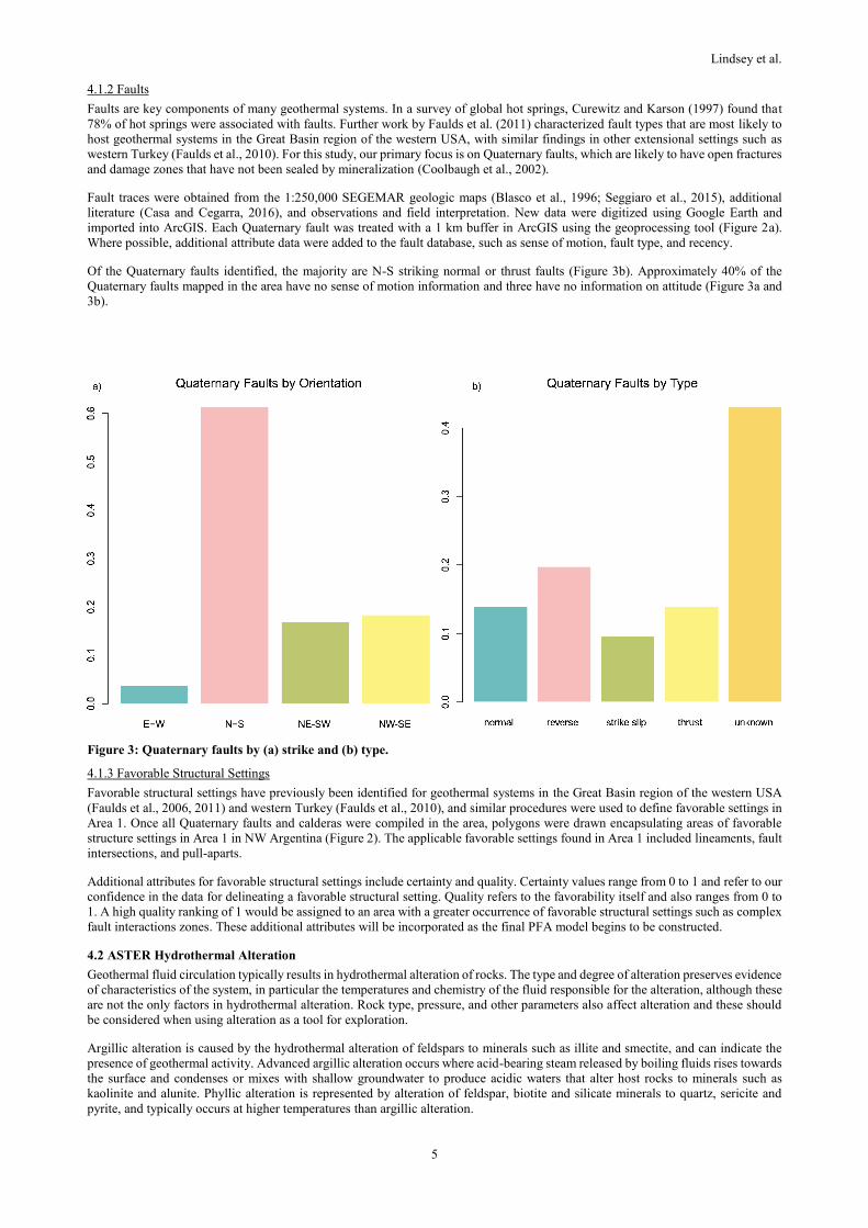
4.1.2 Faults
Faults are key components of many geothermal systems. In a survey of global hot springs, Curewitz and Karson (1997) found that
78% of hot springs were associated with faults. Further work by Faulds et al. (2011) characterized fault types that are most likely to
host geothermal systems in the Great Basin region of the western USA, with similar findings in other extensional settings such as
western Turkey (Faulds et al., 2010). For this study, our primary focus is on Quaternary faults, which are likely to have open fractures
and damage zones that have not been sealed by mineralization (Coolbaugh et al., 2002).
Fault traces were obtained from the 1:250,000 SEGEMAR geologic maps (Blasco et al., 1996; Seggiaro et al., 2015), additional
literature (Casa and Cegarra, 2016), and observations and field interpretation. New data were digitized using Google Earth and
imported into ArcGIS. Each Quaternary fault was treated with a 1 km buffer in ArcGIS using the geoprocessing tool (Figure 2a).
Where possible, additional attribute data were added to the fault database, such as sense of motion, fault type, and recency.
Of the Quaternary faults identified, the majority are N-S striking normal or thrust faults (Figure 3b). Approximately 40% of the
Quaternary faults mapped in the area have no sense of motion information and three have no information on attitude (Figure 3a and
3b).
Figure 3: Quaternary faults by (a) strike and (b) type.
4.1.3 Favorable Structural Settings
Favorable structural settings have previously been identified for geothermal systems in the Great Basin region of the western USA
(Faulds et al., 2006, 2011) and western Turkey (Faulds et al., 2010), and similar procedures were used to define favorable settings in
Area 1. Once all Quaternary faults and calderas were compiled in the area, polygons were drawn encapsulating areas of favorable
structure settings in Area 1 in NW Argentina (Figure 2). The applicable favorable settings found in Area 1 included lineaments, fault
intersections, and pull-aparts.
Additional attributes for favorable structural settings include certainty and quality. Certainty values range from 0 to 1 and refer to our
confidence in the data for delineating a favorable structural setting. Quality refers to the favorability itself and also ranges from 0 to
1. A high quality ranking of 1 would be assigned to an area with a greater occurrence of favorable structural settings such as complex
fault interactions zones. These additional attributes will be incorporated as the final PFA model begins to be constructed.
4.2 ASTER Hydrothermal Alteration
Geothermal fluid circulation typically results in hydrothermal alteration of rocks. The type and degree of alteration preserves evidence
of characteristics of the system, in particular the temperatures and chemistry of the fluid responsible for the alteration, although these
are not the only factors in hydrothermal alteration. Rock type, pressure, and other parameters also affect alteration and these should
be considered when using alteration as a tool for exploration.
Argillic alteration is caused by the hydrothermal alteration of feldspars to minerals such as illite and smectite, and can indicate the
presence of geothermal activity. Advanced argillic alteration occurs where acid-bearing steam released by boiling fluids rises towards
the surface and condenses or mixes with shallow groundwater to produce acidic waters that alter host rocks to minerals such as
kaolinite and alunite. Phyllic alteration is represented by alteration of feldspar, biotite and silicate minerals to quartz, sericite and
pyrite, and typically occurs at higher temperatures than argillic alteration.

Lindsey et al.
6
ASTER data for Area 1 were used to identify zones of hydrothermal alteration. The ASTER L1T images (14 bands per scene) were
orthorectified and corrected for any crosstalk effect present in the SWIR bands of ASTER. The images were then converted from
radiance to reflectance by applying an atmospheric correction using the FLAASH module of the ENVI program. Identification of the
hydrothermal alteration zones was made through the application of algebra and logical relations between bands with the establishment
of thresholds using the Band Math tool in ENVI (Exelis Visual Information Solutions, Boulder, Colorado) following the methodology
of Mars (Mars and Rowan, 2006; Mars, 2013). Hydrothermal alteration types identified were argillic, phyllic, propylitic, and silicic.
Subsequently, a mosaic was generated for each type of alteration. The results were then exported to a shapefile format after
elimination of false positives.
Upon comparison of the alteration layer and the volcanic ages layer, it was determined that further refinement of the alteration ages
could be achieved by cross-referencing the alteration ages with the ages of the volcanic units the alteration coincides with. This work
was completed in ArcGIS. Alteration was plotted as type of alteration (Figure 4a) as well as approximate age of alteration (Figure
4b), which was determined from regional geology.
In this PFA, age of alteration may be an indication of remnant heat being present, especially with Quaternary age alteration. Alteration
of this age is found near Quaternary age calderas such as Aguas Calientes and Coranzulí as well as near Cerro Tuzgle. Further
refinements of age of alteration will be accomplished using information from more recent geologic mapping efforts. This work is
expected to continue.
Of the four types of alteration inferred from the ASTER data, two are used for this study – phyllic and argillic. Silica alteration can
be valuable when it is associated with young silicification; however, the silica mapped is most likely associated with silica-rich rocks
such as quartzite and sandstone and thus is not very useful. Propylitic alteration is used to characterize the heart of many high-
temperature geothermal systems, but to see this type of alteration at the surface often signifies extinct, eroded, and exposed cores of
geothermal systems. It is unexpected to see this type of alteration at the surface of an active system and when it is found it is more
indicative of a breached system that may no longer be producible.
Argillic alteration appears to be the most common of the alteration types identified in Area 1. Mapped areas of phyllic alteration
appear around all identified geothermal areas and surface manifestations. There is also a large area of phyllic alteration in one of the
salars to the east of Cerro Tuzgle that we interpret as salt deposits. Argillic with some silicic alteration is predominant in Aguas
Caliente and other smaller thermal areas that fall along the COT moving off to the southeast (Figure 4a).
Figure 4: Surface hydrothermal alteration map by (a) type derived from ASTER images and (b) approximate age.
4.4 Volcanic Ages
Heat flow data are scarce in Area 1; therefore, other datasets that give some indication of heat were necessary. Here, we used the age
of volcanism as an indicator of current and/or past presence of heat. Area 1 has multiple areas of volcanics less than 5 Ma. The Cerro
Tuzgle-Tocomar area as well as Aguas Caliente in the south are primarily in this age range. Coranzulí has relatively young, late
Miocene volcanics with younger (< 5 Ma) volcanic units to the west along the Ramallo and Coyaguayma fault zones.

Lindsey et al.
7
Type of rock was also collected for the project (5b). Volcanic units were subdivided into felsic, intermediate, and mafic. We inferred
that felsic volcanic rocks are more likely to be a heat source for geothermal systems in the Puna, due to larger volumes and greater
crustal interaction (vs the simple, mono-genetic basaltic cinder cones in the area).
Igneous geology was gathered from SEGEMAR 1:250,000 GIS products (Blasco et al., 1996; Seggiaro et al., 2015). Absolute ages
for the volcanic units were gathered from the Andean Igneous and Non-Igneous Datasets (Pilger, 2018) (Figure 5a). Rock types for
all volcanic units less than 5 Ma are also plotted (Figure 5b).
Figure 5: Volcanic units by (a) absolute age and (b) rock type.
4.5 Hot Springs
Hot springs and other surface manifestations are often the first indication of the presence of a geothermal system. The presence of
springs can provide information regarding all three components of a geothermal system – heat, fluid, and permeability. For these
reasons, spring data were identified as compulsory for the study.
Hot spring data were compiled from a catalog of manifestations published by SEGEMAR (Pesce and Miranda, 2003). The catalog
contained duplicate values for some locations, disparate quality of location values, and was missing some newly identified springs.
The catalog was supplemented with spring data from various researchers (Aquater, 1981; Sierra and Pedro, 1988; Dames and Moore,
1999; Salusso and Moraña, 2015; Carrizo, 2015; Carrizo, 2015b; Carrizo, 2016a; Carrizo, 2016b; and Peralta et al., 2016) Springs
were plotted as points, and for the purposes of the future PFA, were mapped with a 2.5 kilometer buffer zone as the heat, fluid, and/or
permeability likely extends some distance from the point location of the spring itself (Figure 6a).
As expected, many of the springs fall around identified geothermal areas. A southern cluster is associated with Cerro Tuzgle,
Tocomar, and Aguas Caliente. Northward toward Coranzulí, the springs follow a N-S trend and move off to the west following the
faults that bound the Coranzulí caldera. It should be noted that this is not an exhaustive list of thermal springs in Area 1 but represents
those documented to date.
Over 50% of the springs fell into two categories, 15-30 °C or 40-55 °C, and six springs in the area had recorded field temperatures
of over 65 °C. All springs with measured temperatures over 65 °C were south of Tuzgle in the Tocomar geothermal area. Most of the
measured temperatures around Coranzulí were low temperature (< 30 °C), but there were higher temperature springs west of
Coranzulí associated with the two major lineaments in the area (the Coyaguayma and Rachaite lineaments).

Lindsey et al.
8
.
Figure 6: Springs temperatures (a) and geothermometry with a 2.5 km buffer zone
4.6 Geochemistry
4.6.1 Geochemistry
Geochemical data for Area 1 were compiled from various published and unpublished sources. Key sources include Panarello et al.
(1992), Pesce and Miranda, (2003), Carrizo (2015a), and Peralta et al. (2016). In total, 132 geochemical analyses of spring or stream
waters were available; however, of these, only 113 had an ionic charge balance within 10% and were used for subsequent
interpretation and evaluation. Samples were obtained from the following geothermal areas: Aguas Calientes, Antuco, Aritzar, Baños
de Pompeya, Baños de Incachule, Cerro Tuzgle, Cono Panizo, Coranzulí, Mina Pirquitas, Olaroz, Orosmayo, Pairique, Queñual,
Rachaite, Salar de Rincón, Tocomar and Vilama. Review of the data indicates that most fluids are alkali-chloride or bicarbonate
waters – only a couple of samples are sulfate-dominated (Figure 7). Total dissolved solids range from less than 1000 mg/l, to over
300,000 mg/l. Most samples contain less than 10,000 mg/l.
4.6.2 Geothermometry
For the purposes of the PFA of Area 1, the geochemistry data were reviewed to evaluate which geothermometers were appropriate to
apply to the samples to estimate reservoir equilibration temperatures. Many of the samples are not classified as mature alkali-chloride
fluids (Figure 7), thus it is not appropriate to apply traditional cation geothermometers to these samples, and our initial evaluations
thus used the SiO2 geothermometer to estimate sub-surface temperatures. Additionally, for some locations there were several spring
and stream samples collected for an area. The samples chosen for SiO2 geothermometry were those collected from the hottest springs
in an area, as we infer that these are the most representative of the deep geothermal system, and should thus be more reliable. We
applied the conductive quartz geothermometer to these representative measurements initially: if the quartz (conductive)
geothermometer estimated temperatures less than 120 °C, the chalcedony (conductive) geothermometer was used instead. The results
indicate that the highest estimated equilibration temperature was 172 °C at the Tocomar geothermal system. Similar temperatures
were estimated at Cerro Tuzgle, and Queñual. Geothermometry values are plotted with the same 2.5 kilometer buffer as used with
the hot springs (Figure 6b).
Future efforts will perform multiple-component equilibrium geothermometry calculations to evaluate reservoir equilibration
temperatures, and see how these compare to the silica geothermometry.

Lindsey et al.
9
Figure 7: Ternary plots of the fluid chemistry samples compiled for the target PFA area in the Puna, NW Argentina. (a) Cl-
SO4-HCO3, (b) Cl-F-B, (c) Cl vs SO4 cross plot (d) Total Dissolved Solids vs Cl.
4.7 Geophysics
4.7.1 Magnetic Data
The magnetometry information compiled for this project corresponds to the combination of the Puna Norte and Salta-Catamarca
geophysical datasets, belonging to SEGEMAR. These data were processed with two filters: first vertical derivative of the magnetic
field reduced to the pole, and analytic signal. The first technique highlights the magnetic effects caused by relatively shallow and
local bedrock characteristics, such as magnetized intra-sedimentary faults. The analytical signal filter is used to detect geological
discontinuities associated with magnetization (contrasts of magnetic susceptibility), such as faults or dykes and contacts of intrusive
bodies, which are represented as maximums in the grid. However, when comparing the results of this filter with the hydrothermal
alteration areas (identified by the band ratio of RGB 4/5, 4/6 and 4/8 of the ASTER image), the grid had local minimum values in the
alteration zones. This is possibly associated with the destruction of the magnetite by alteration fluids. The map of magnetic anomalies
can be seen in Figure 9a.
Upon review, the location of magnetic lows does not appear to be associated with alteration as anticipated. This layer will not be used
in the final PFA product for this reason. The lows seems well dispersed across Area 1 with the exception of the calderas and volcanic
centers.
4.7.2 Horizontal Gravity Gradient
Gravity data were provided to SEGEMAR by IGN (Argentina’s National Geographic Institute). The gravity stations are somewhat
limited for the area, thus our map may not capture the true spatial variability in gravity. There are 231 measurements for Area 1, most
along roadways and a cluster around Cerro Tuzgle. A density for topography of 2670 kg/m3 was applied. We interpolated the
gravimetric data, calculated the first order horizontal derivatives of the field, and applied a horizontal gradient filter. The objective of
this technique was to identify the rapid lateral changes of density, as can happen across vertical formation contacts or at the edges of
a sub-surface body.
For geothermal exploration, gravity gradients can be used to identify possible structural discontinuities that may be associated with
faulting (and thus potential permeability). Density contrasts between formations that are displaced across a fault will produce changes
in horizontal gravity gradient. This is especially true at the margins of ranges where normal faults are down-dropping rocks allowing
colluvium to accumulate in basins. In Area 1, we generally observe north-south trending zones of high and low horizontal gravity
anomalies, which likely reflect the structural fabric of the area and variable lithologies of the thrust sheets. However, the low data

Lindsey et al.
10
density for Area 1 does not provide sufficient spatial resolution to resolve such density contrasts, and consequently the team decided
not to use this layer in the play fairway model of the area.
Figure 9: Geophysical data for Area 1 includes aeromagnetometry, plotted here as magnetic low anomalies of the analytic
signal (a); and horizontal gravity gradient (b) with stations plotted.
4.7.3 Earthquake data
Areas of active tectonic activity and earthquake occurrence commonly coincide with areas that have geothermal resource potential
(Coolbaugh et al., 2002). A relatively high stress field is required to fracture rock and dynamically maintain open fractures in the
rock (Curewitz and Karson, 1997) (which is important for maintaining permeability in some geothermal systems), and the presence
of earthquakes in an area can be an indicator of such high levels of stress.
Earthquake data for the study were acquired from the National Institute of Seismic Prevention (INPRES). The original data span a
date range from December 30, 1999 to January 23, 2019 and include > 6,000 points. As the data covered two separate provinces,
some work was needed to standardize the data. The date format was different for the two provinces, and these were converted to the
scientific format (yyyy-mm-dd). The second “cleaning” of the data involved removing earthquakes with focal depths of greater than
20 km, as these would not likely be related to crustal geothermal systems (Figure 10).
5. DISCUSSION
5.1 Controls on geothermal systems in the Puna
Geothermal centers in Area 1 and of the Puna tend to be associated with young volcanic systems, such as Tuzgle and Coranzulí.
These volcanic centers and calderas appear to be structurally controlled. We speculate that faults and fractures associated with
multiple caldera forming eruptions provide pathways for recharge and geothermal fluid migration to the surface at Coranzulí. The
Tuzgle geothermal system may be recharged from high altitude ridges above 4,500 m (Giordano et al., 2013). At lower elevations,
upwelling geothermal fluids exhibit plume-like movement in areas such as Tocomar, where the valley cover seals the fractured
Ordovician basement that is thought to host geothermal reservoirs in the area (Coira, 1995).
Tocomar produces higher temperature surface fluids, and this has been attributed to the intersection of the COT and secondary
extensional structures in the area (Giordano et al., 2013), creating a complex and thus more favorable structural setting (Faulds et al.,
2011), and therefore greater potential for permeability. Thermal areas to the southeast of Tocomar are likely similarly controlled, as
are thermal areas to the northwest of Coranzulí.
Geothermal centers of Puna play fairway Area 1 tend to be associated with deep reactivated fractures zones as Coyaguayma and COT
lineaments where volcanic centers and calderas appear to be structurally controlled. We infer that faults and fractures associated with
multiple caldera forming eruptions such as Aguas Calientes and Coranzulí also provide pathways for recharge and fluid migration to
the surface from deep geothermal reservoirs.

Lindsey et al.
11
Figure 10: Earthquake (a) locations (for depths of less than 20 km) and density and (b) magnitude.
The highest temperature surface fluids in Area 1 are at Tocomar geothermal system where we see favorable structural settings
conducive to high potential permeability (Faulds, 2011): these are attributed to the intersection of the COT and secondary extensional
structures (Giordano et al., 2013), a magmatic heat source evidenced by Quaternary volcanic activity such as San Geronimo and
Negro de Chorrillos monogenic cones and Tocomar ignimbrite and the fractured Ordovician basement that is thought to host
geothermal reservoirs in the area (Coira, 1995). Even when there is no evidence of Quaternary volcanism along the Coyaguayma
lineament, we suggest that thermal areas to the northwest of Coranzulí are structurally controlled in a similar fashion as the Tocomar
geothermal system. The Tuzgle geothermal field is a system associated with Quaternary volcanic activity with no evident structural
control. Other similar systems exists in the Puna such as Cono Panizo, Olaroz, Orosmayo, Pairique, and Vilama although they are
not in the current study area. It is possible a better understanding of the geothermal system associated with Tuzgle with give insight
into the others as well.
5.2 Determining value of each dataset for PFA
Many datasets were gathered and layers created that can give some insight to geothermal resource potential. As the next stage of the
project moves forward and weightings are assigned so that layers can be combined to produce the play fairway, it is important to
determine the role of each dataset. For traditional geothermal systems, three properties are required: heat, permeability, and fluid.
Each of the layers generated represents the potential for one, two, or all these three properties. For this project, we allocated the
various datasets to one (or more) of these three categories (Table 1).
Table 1: Datasets by geothermal property represented
Heat Permeability Fluid
Age of hydrothermal alteration Age of hydrothermal alteration Age of hydrothermal alteration
Presence of hot springs Presence of hot springs Presence of hot springs
Geothermometry Faults Cold Springs
Volcanic ages Quaternary faults
Favorable structural setting
Earthquakes
Calderas
6. CONCLUSIONS
For Argentina, we anticipate that the results of this PFA will provide insight into future exploration priorities for Area 1. As mentioned
previously, missing data and data disparity provided a challenge for the team, but as the PFA is an iterative process that can be
updated as new data become available, this initial PFA can be improved in the future. We anticipate that areas with previously
unrecognized geothermal potential in Area 1 as identified by the PFA may provide targets for future exploration to fill in missing
data gaps, as well as to confirm previously-collected data to increase confidence in selected layers. As confidence increases and gaps
are filled, the model can be adjusted, and it is possible that exploration targets can be refined even further. Additionally, the completed

Lindsey et al.
12
PFA can be combined with direct evidence and conceptual models to increase our understanding of the geothermal systems in Area
1, and it is possible that data compiled during this project can be used to fine-tune previous conceptual models of the area such as
those proposed by Giordano et al. (2013).
ACKNOWLEDGEMENTS
This work was supported by award SLMAQM17CA1186 from the United States Department of State to the University of Nevada,
Reno. Jenna Schroeder and Derek Wong from the United States Department of State are thanked for logistical support in Argentina,
and Olivia Sierra from the United States Department of Interior is thanked for her help with translation services. Agostina Chiodi at
the Universidad Nacional de Salta, is thanked for discussions and provision of some water geochemical data. Yésica Peralta at the
Universidad Nacional de Jujuy is thanked for shared her water geochemistry data. And obviously to the all team of the professionals
of SEGEMAR.
Disclaimer: Views expressed are those of the author and do not necessarily reflect those of the Department of State or the United
States Government.
REFERENCES
Allmendinger, R.W., Jordan, T., Kay, S., and Isacks, B.: The Evolution of the Altiplano–Puna Plateau of Central Andes, Annual
Review Earth Planet Sciences, 25, (1997), 139-174.
Allmendinger, R.W., Ramos, V.A., Jordan, T.E., Palma, M., Isacks, B.L.: Paleogeography and Andean Structural Geometry,
Northwest Argentina, Tectonics, 2, (1983), 1-16.
Aquater, Exploración geotérmica del área del Cerro Tuzgle. Provincia de Jujuy, República Argentina. Secretaria de Estado de
Minería, Argentina (Inédito), 170 p., Buenos Aires, (1980).
Battocletti, L. (1999) Database of Geothermal Resources in Latin American & the Caribbean. Report for Sandia National
Laboratories, Bob Lawrence & Associates Inc., Contract No. AS-0989.
Blasco, Graciela; Zappettini, Eduardo O.; Hongn, Fernando D., Servicio Geológico Minero Argentino. Instituto de Geología y
Recursos Minerales, Hoja Geológica 2566-I San Antonio de los Cobres, (1996).
Bona, P. and Coviello, M.F.: Valoración y Gobernaza de Los Proyectos Geothérmicos en América del Sur. Comisión Econónomic
para América Latiana y el Caribe. (2016).
Carrizo, N.; Estudio Geológico y Geoquímico de un Campo Geotérmico, Caso de Estudio: Argentina, Trabajo de Especializacion,
Universidad de El Salvador, Republica de El Salvador (2015a).
Carrizo, N.: Resultados Quimicos de Muestras. Laboratorio de INGEIS, UBA, Inedito, (2015b).
Carrizo, N.: Datos de Campo, Inedito, (2016a).
Carrizo, N.: Resultados Quimicos de Muestras. Laboratorio de CICTERRA. CONICET, UNC. Inedito (Cordoba), (2016b).
Coira, B.: Cerro Tuzgle Geothermal Prospect, Jujuy, Argentina, Proceedings of the World Geothermal Congress, 2, Florence, Italy
(1995), 1161-1165.
Cole, J.W., Milner, D.M, and Spinks, K.D.: Calderas and Caldera Structures: A Review, Earth-Science Reviews, 69, (2005), 1-26.
Coolbaugh, M.F., Taranik, J.V., Raines, G.L., Shevenell, L.A., Sawatzky, D.L., Bedell, R., and Minor, T.B.: A Geothermal GIS for
Nevada: Defining Regional Controls and Favorable Exploration Terrains for Extensional Geothermal Systems, Transactions
Geothermal Resources Council, 26, (2002), 485-490.
Cox, M.E. and Browne, P.: Hydrothermal Alteration Mineralogy as an Indicator of Hydrology at the Ngawha Geothermal Field, New
Zealand, Geothermics, 27, (1998), 259-270.
Craig, Jason: Discovery and Analysis of a Blind Geothermal System in Southeastern Gabbs Valley, Western Nevada (Master’s thesis).
University of Nevada Reno, (2018).
Dames and Moore: Provincial Plan for Sampling of Water Resources and Current Sediments Study Areas of the Province of Jujuy,
Basic Environmental Studies, PASMA Project, (1999).
del Papa, C.E. and Petrinovic, I.A.: The Development of Miocene Extensional and Short-lived Basin in the Andean Broken Foreland:
The Conglomerado Los Patos, Northwestern Argentina, Journal of South American Earth Sciences, 72, (2017), 191-201.
Faulds, J.E., Coolbaugh, M.F., Vice, G.S., and Edwards, M.L.: Characterizing Structural Controls of Geothermal Fields in the
Northwestern Great Basin: A Progress Report: Geothermal Resources Council Transactions, 30, (2006), 69-76.
Faulds, J.E., Coolbaugh, M., Bouchot, V., Moeck, I., and Oğuz, K., 2010, Characterizing Structural Controls of Geothermal
Reservoirs in the Basin and Range, USA, and Western Turkey: Developing Successful Exploration Strategies in Extended
Terranes, Proceedings of the World Geothermal Congress, Bali, Indonesia, (2010).
Faulds, J.E., Hinz, N.H., Coolbaugh, M.F., Cashman, P.H., Kratt, C., Dering, G.D., Edwards, J.E., Mayhew, B., and McLachlan, H.:
Assessment of Favorable Structural Settings of Geothermal Systems in the Great Basin, Western USA, Transactions,
Geothermal Resources Council, 35, (2011), 777-783.
Faulds, J.E., Hinz, N.H., Coolbaugh, M.F., dePolo, C.M., Siler, D.L., Shevenell, L.A., Hammond, W.C., Kreemer, C., and Queen,
J.H.: Discovering Geothermal Systems in the Great Basin Region: An Integrated Geologic, Geochemical, and Geophysical

Lindsey et al.
13
Approach for Establish Geothermal Play Fairways, Proceedings, 41st Workshop on Geothermal Reservoir Engineering, Standard
University, Stanford, CA, (2016).
Faulds, J.E., Hinz, N.H., Coolbaugh, M.F., Shevenell, L.A., Siler, D.L., dePolo, C.M., Hammond, W.C., Kreemer, C., Oppliger, G.,
Wannamaker, P.E., Queen, J.H., and Visser, C.F.: Integrated Geologic and Geophysical Approach for Establishing Geothermal
Play Fairways and Discovering Blind Geothermal Systems in the Great Basin Region, Western USA: A Progress Report,
Transactions, Geothermal Resources Council, 39, (2015), 691-700.
Gillespie, A. R., Lithologic mapping of silicate rocks using TIMS, in The TIMS Data Users’ Workshop, JPL Publications, (1985),
86-38, 29–44.
Grier, M.E. Salfity, J.A., and Allmendinger, R.W.: Andean Reactivation of the Cretaceous Salta Rift, Northwestern Argentina,
Journal of South American Earth Sciences, 4, (1991), 351-372.
Giordano, G., Pinton, A., Cinanfarra, P., Baez, W., Chiodi, A., Viramonte, J., Norini, G., Groppelli, G.: Structural Control on
Geothermal Circulation in the Cerro-Tuzgle-Tocomar Geothermal Volcanic Area (Puna Plateau, Argentina), Journal of
Volcanology and Geothermal Research, 249, (2013), 77-94.
Hongn, F., Mon, R., Petrinovic, I., del Papa, C., y Powell, J. 2010. Inversión y reactivación tectónicas cretácico-cenozoicas en el
noroeste argentino: Influencia de las Heterogeneidades del Basamento Neoproteroico-Paleozoico Inferior, Asociación Geológica
Argentina, Revista, 66, 38-53.
Hurwitz, S., Farrar, C.D., and Williams, C.F.: The Thermal Regime in the Resurgent Dome of Long Valley Caldera, California:
Inferences from Precision Temperature Logs in Deep Wells, Journal of Volcanology and Geothermal Research, 198, (2010),
233-240.
Isacks, B.L.: Uplift of the Central Andean Plateau and Bending of the Bolivian Orocline, Journal of Geophysical Research, 93,
(1988), 3211-3231.
Jordan, T. y Alonso, R.: Cenozoic stratigraphy and basin tectonics of the Andes Mountains, 20º28º South latitude: American
Association of Petroleum Geologist, Bulletin, 71, (1987), 49-64.
Kay, S.M., Coira, B., and Mpodozis, C.: Field Trip Guide: Neogene Evolution of the Central Andean Puna Plateau and Southern
Central Volcanic Zone, Geological Society of America, Field Guide 13, (2008).
Lahsen, A., Rojas, J., Morata, D., and Aravena, D.: Exploration for High-Temperature Geothermal Resources in the Andean Countries
of South America, Proceedings World Geothermal Congress, Melbourne, Australia, (2015).
Lanza, F., Tibaldi, A., Bonali, F. L. y Corazzato, C.L: Space–Time Variations of Stresses in the Miocene–Quaternary Along the
Calama–Olacapato–El Toro Fault Zone, Central Andes, Tectonophysics, 593, (2013) 33–56.
Mars, J.C. , 2013, Hydrothermal alteration maps of the central and southern Basin and Range province of the United States compiled
from Advanced Spaceborne Thermal Emission and Reflection Radiometer (ASTER) data ver 1.1, April 8, 2014: U.S. Geological
Survey Open-File Report 2013–1139, 6 p., 13 plates, scale 1:1,300,000, http://dx.doi.org/10.3133/ofr20131139.
Mars, J.C., and Rowan, L.C., 2006, Regional mapping of phyllic- and argillic-altered rocks in the Zagros magmatic arc, Iran, using
Advanced Spaceborne Thermal Emission and Reflection Radiometer (ASTER) data and logical operator algorithms: Geosphere,
v. 2, p. 161–186, 2 plates, doi:10.1130/GES00044.1.
Mas, L.C.: Present Status of the Copahue Geothermal Project, Proceedings, World Geothermal Congress, Antalya, Turkey (2005).
Matthew, M. W., S. M. Adler-Golden, A. Berk, S. C. Richtsmeier, R. Y. Levine, L. S. Bernstein, P. K. Acharya, G. P. Anderson,
G.W. Felde, M. P. Hoke, A. Ratkowski, H.-H. Burke, R. D. Kaiser, and Miller, D.P.: Status of Atmospheric Correction Using a
MODTRAN4-based Algorithm. SPIE Proceedings, Algorithms for Multispectral, Hyperspectral, and Ultraspectral Imagery VI.
Vol. 4049, (2000), 199-207.
Mon, R. y Salfity, J.A: Tectonic Evolution of the Andes of Northern Argentina. En: Tankard, A. J., Suárez, R. and Welsink (eds.):
Petroleum Basins of South America. American Association of Petroleum Geologists, Memoir, 62, (1995), 269-283.
Nielsen, G., Maack, R., Gudmundsson, Á., and Gunnarsson, G.I.: Completion of Krafla Geothermal Power Plant, Proceedings, World
Geothermal Congress, Kyushu-Tohoku, Japan, (2000).
Panarello, H., Sierra, J.L. and Pedro, G., 1992. Flow Patterns at the Tuzgle-Tocomar Geothermal System, Salta-Jujuy, Argentina,
Geothermal Investigations with Isotope and Geochemical Techniques in Latin America - proceedings of a final research
coordination meeting in San Jose, Costa Rica, IAEA-TECDOC-641, (1990), 452pp.
Peralta Arnold, Y., Cabassi, J., Tassi, F., Caffe, P. J., Vaselli, O.: Geochemistry of the hydrothermal systems in the Jujuy Province,
Argentina, and relationship with the regional geology. Geophysical Research Abstracts, 18, EGU2016 (2016).
Peralta Arnold, Y.J., Cabassi, G., Tassi, F., Caffe, P.J., and Vaselli, O.: Fluid Geochemistry of a Deep-seated Geothermal Resource
in the Puna Plateau (Jujuy Province, Argentina), Journal of Volcanology and Geothermal Research, 338, (2017), 121-134.
Perkins, J.P., Ward,K., de Silva,S., Zandt,G., Beck, S., and Finnegan, N. : Surface uplift in the Central Andes driven by growth of
the Altiplano Puna Magma Body. Nature Communications DOI: 10.1038/ncomms13185 (2016).
Pesce, A. and Miranda, F. Catálog de Manifestaciones Termales de la República Argentina. Vol. I-II Región Noroeste. SEGEMAR,
Buenos Aires, 1666–3462 (2003).
Pesce, A.: Argentina Country Update, Proceedings, World Geothermal Congress, Melbourne, Australia, (2015).

Lindsey et al.
14
Petrinovic, I.A.: Volcanismo Cenozoico Asociado al Lineamiento Calama– Olacapato–El Toro en el Tramo Comprendido Entre San
Antonio de los Cobres y Olacapato, Provincia de Salta, Argentina (PhD thesis), Universidad Nacional de Salta, Argentina.
Unpublished, (1994).
Petrinovic, I.A., Mitjavila, J., Viramonte, J.G., Marti, J, Becchio, R., Arnosio, M. y F. Colombo, 1999. Geoquímica y Geocronología
de secuencias volcánicas Neógenas de trasarco, en el extremo oriental de la Cadena Volcánica Transversal del COT, noroeste
de Argentina. In: Colombo, F., Queralt, I. y Petrinovic, I.A. Geología de los Andes Centrales Meridionales: El Noroeste
Argentino, Acta Geológica Hispánica 34 (2-3) 255-273, (1999).
Petrinovic, I. Colombo Piñol, F.: Phreatomagmatic and Phreatic Eruptions in Locally Extensive Settings of Southern Central Andes:
The Tocomar Volcanic Centre (24°10′S–66°34′W), Argentina. Journal of Volcanology and Geothermal Research, 158, (2006),
37-50.
Petrinovic, I.A., Martí, J., Aguirre-Díaz, G.J., Guzmán, Geyer, A., and Salado Paz, N.: The Cerro Aguas Calientes Caldera, NW
Argentina: An Example of a Tectonically Controlled, Polygenetic Collapse Caldera, and Its Regional Significance, Journal of
Volcanology and Goethermal Research, 194, (2010), 15-26.
Pilger, R.: Andean Igneous and Non-Igneous Datasets. Unpublished raw data.
https://www.researchgate.net/publication/328130067_Andean_Igneous_and_Non-Igneous_Datasets, (2018).
Quade, J., Dettinger, M.P., Carrapa, B., DeCelles, P., Murray, K.E., Huntington, K.W., Cartwright, A., Canavan, R.R., Gehrels, G.,
and Clementz, M: The Growth of the Central Andes, 22°S–26°S, in DeCelles, P.G., Ducea, M.N., Carrapa, B., and Kapp, P.A.,
eds., Geodynamics of a Cordilleran Orogenic System: The Central Andes of Argentina and Northern Chile: Geological Society
of America Memoir 212, (2015), 277-308.
Riller, U., Petrinovic, I., Ramelow, J., Strecker, M., and Oncken, O.: Late Cenozoic Tectonism, Collapse Caldera and Plateau
Formation in the Central Andes, Earth and Planetary Science Letters, 188, (2001), 299-311.
Saemundsson, K.: Geothermal Systems in Global Perspective, Short Course VIII on Exploration for Geothermal Resources, Kenya
(2013).
Salfity, J.A., Omarini, R., Baldis, B. y Gutiérrez, W.J.: Consideraciones Sobre la Evolución Geológica del Precámbrico y Paleozoico
del Norte Argentino. II Congreso Ibero-Americano de Geología Económica, 4, (1974), 341-361.
Salusso, M., Moraña, L.: Estructura y Composición del Fitoplancton de Mina Pirquitas, Jujuy, Argentina. Revista Mexicana de
Biodiversidad, 86(3), (2015), 711-718.
Seggiaro, R.: Petrologia Geoquimica y Mecanismos de Erupción del Complejo Volcanico Coranzuli (PhD Thesis, unpublished),
Universidad Nacional de Salta, (1994).
Seggiaro, R. and Hongn, F.: Tectónica Transcurrente Asociada al Colcán Coranzulí, Jujuy, 559 Argentina. 7º Congreso Geológico
Chileno, Actas 1, Concepción, (1994), 169-173.
Seggiaro, R.E.: Variaciones Estructurales a lo Largo del Lineamiento Calama – Olacapato – Toro en el Noroeste Argentino, XI
Congreso Geológico Chileno, Actas, 2, Geodinámica Andina (2006).
Seggiaro, R., Guzman, S., Marti, J., Montero, C., and Lopez, E.: Stratigraphy of the Coranzulí Caldera, in: Rocha, R., Pais, J., Kullber,
J., and Finney, S. (eds), STRATI 2013. Springer Geology, (2014).
Seggiaro, Raúl E.; Becchio, Raúl; Bercheñi, Víctor; Ramallo, L.; Franchi, Mario; Servicio Geológico Minero Argentino. Instituto de
Geología y Recursos Minerales, Hoja Geológica 2366-III Susques, (2015).
Seggiaro, R.E., Guzmán, S.R. y Apaza, F.D.. Control Estructural Sobre el Magmatismo en los Alrededores de San Antonio de Los
Cobres, Sector Oriental de la Puna Central. XX Congreso Geológico Argentina, Actas S.T. 2: Geología Estructural y
Geotectónica, (2017a ),142-146.
Seggiaro, R.E., Villagrán, C.A., Celedón, M.R., Barrabino, E. y Apaza, F.D.: Reactivación de Fallas Paleozoicas Durante la Tectónica
Andina en la Cordillera Oriental-Noroeste Argentino. En: Muruaga, C.M. y Grosse, P. (Eds.), Ciencias de la Tierra y Recursos
Naturales del NOA, Relatorio del XX Congreso Geológico Argentino, San Miguel de Tucumán, (2017), 595-616.
Seggiaro, R., Guzmán, S. Pereyra, R., Coppolecchia, M. and Cegarra, M: Neotectonica y Volcanismo Monogenético Cuaternario
Sobre el Segmento Dentral del Lineamiento Calama Olacapato Toro (COT), NO Argentino, Revista de la Asociación Geológica
Argentina. issn 0004-4822, (2016).
Seggiaro, R., Guzman S., Marti, J.: Dynamics of caldera collapse during the Coranzulí eruption (6.6 Ma) (Central Andes, Argentina).
Journal of Volcanology and Geothermal Research, 374, (2019).
Sierra J. L. y Pedro G.: Estudio Geotérmico del Area Tuzgle - Tocomar - Pompeya. Centro Regional, (1987-88).
Sobrino, J. A., Li, Z. L., Soria, G. and. Jimenez, J. C.: Land Surface Temperature and Emissivity Retrieval from Remote Sensing
Data. Recent Research Developments in Geophysics, 4, (2002), 21-44.
Spinks, K.D., Acocella, V., Cole, J.W., and Bassett, K.N.: Structural Control of Volcanism and Caldera Development in the
Transtensional Taupo Volcanic Zone, New Zealand, Journal of Volcanology and Geothermal Research,144, (2005), 7-22.
Suemnicht, G.A. and Sorey, M.L.: The Shallow Hydrothermal System of Long Valley Caldera, California, Proceedings, 32nd
Workshop on Geothermal Reservoir Engineering, Stanford University, Stanford, California, (2007).
Universidad de Salta: Exploración Geotérmica en Puna salteña y cerro Galan – Salar de Antofalla (Catamarca). Universidad Nacional
de Salta. (unpublished), (1982).

Lindsey et al.
15
Weathers, M., Hass, E., Thomas, H., Ziegenbein, M., Prisjatschew, A., Garchar, L., Segneri, B., and Emmons, S.: Geothermal Play
Fairway Projects Initiated by the U.S. Department of Energy, Proceedings, 40th Workshop on Geothermal Reservoir
Engineering, Standard University, Stanford, CA, (2015).
Wilson, C.J.N. and Rowland, J.V.: The Volcanic, Magmatic and Tectonic Setting of the Taupo Volcanic Zone, New Zealand,
Reviewed from a Geothermal Perspective, Geothermics, 59, (2016), 168-187.