Sentinel-2 for Agriculture Project: Mali National ...
21
Sentinel-2 for Agriculture Project: Mali National Demonstration Nicolas Bellemans, Bontemps S., Cara C., Dedieu G., Guzzonato E., Hagolle O., Inglada J., Morin D., Rabaute T., Savinaud M., Udroiu C., Traoré P.C.S., Traoré S.S., Keita B.K., Defourny P., Koetz B. ISRSE37 – Tshwane – 9-12 May 2017
Transcript of Sentinel-2 for Agriculture Project: Mali National ...

Sentinel-2 for Agriculture Project:
Mali National Demonstration Nicolas Bellemans, Bontemps S., Cara C., Dedieu G., Guzzonato E.,
Hagolle O., Inglada J., Morin D., Rabaute T., Savinaud M., Udroiu C., Traoré P.C.S., Traoré S.S., Keita B.K., Defourny P., Koetz B.
ISRSE37 – Tshwane – 9-12 May 2017

Specific challenges for cropland mapping in Mali
Small agriculture field size
Large intra & inter field variability
Tree presence in crops
Diversity of cropping systems
Large diversity of non-cropland land cover
High latitudinal gradient of climatic conditions
Important cloud coverage in low latitude during the vegetation growth
Need of accurate and spatially distributed in situ data
(Lambert et al, 2015)
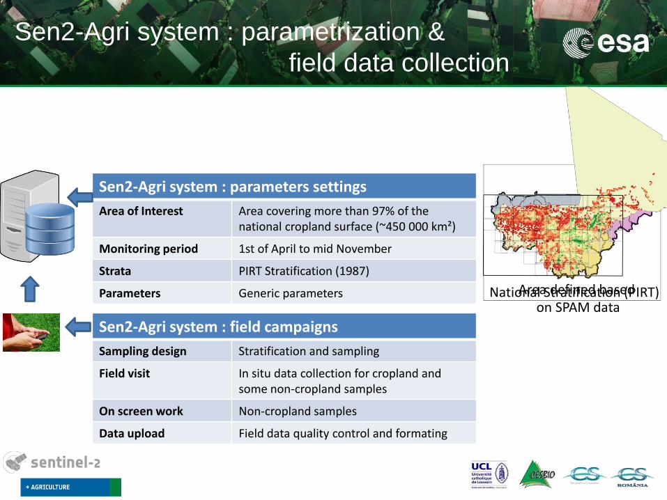
Sen2-Agri system : parameters settings
Area of Interest Area covering more than 97% of the national cropland surface (~450 000 km²)
Monitoring period 1st of April to mid November
Strata PIRT Stratification (1987)
Parameters Generic parameters
Sen2-Agri system : parametrization &
field data collection
Sen2-Agri system : field campaigns
Sampling design Stratification and sampling
Field visit In situ data collection for cropland and some non-cropland samples
On screen work Non-cropland samples
Data upload Field data quality control and formating
National Stratification (PIRT) Area defined based on SPAM data

EO data for 2016 growing season Number of cloud free observation acquired by both S2 and L8
Number of cloud free observation
• L2A S2: 4 TB • L2A L8: 465 GB

National field campaign collecting ~30 000 GPS points
… around 5000 polygons manually digitized by the Institut d’Economie Rural (IER) based on S2 cloud free image composite and recent GE imagery ! Problems in the database prevent us to exploit the crop type information
2016 National Field Campaign By the Cellule de Planification Statistique (CPS)
More than 40 different crop types + 200 different crop associations
Quality control
Cropland samples
Non-Cropland samples
3200 samples of various non-cropland land cover digitized on S2 cloud free image composite and recent GE imagery
8200 samples (~43000 ha)
Splitted into:
- 75% for the calibration - 25% for the validation

First 10 m cropland map over Mali derived
from S2 and L8 data
Cropland
Non-Cropland
Processing time: 3 days starting from the L2A time series

First 10 m cropland map over Mali Koutiala
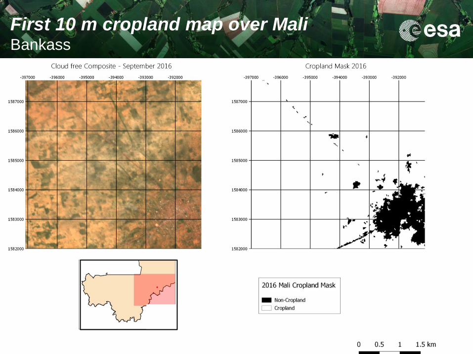
First 10 m cropland map over Mali Bankass

First 10 m cropland map over Mali
Niger Office
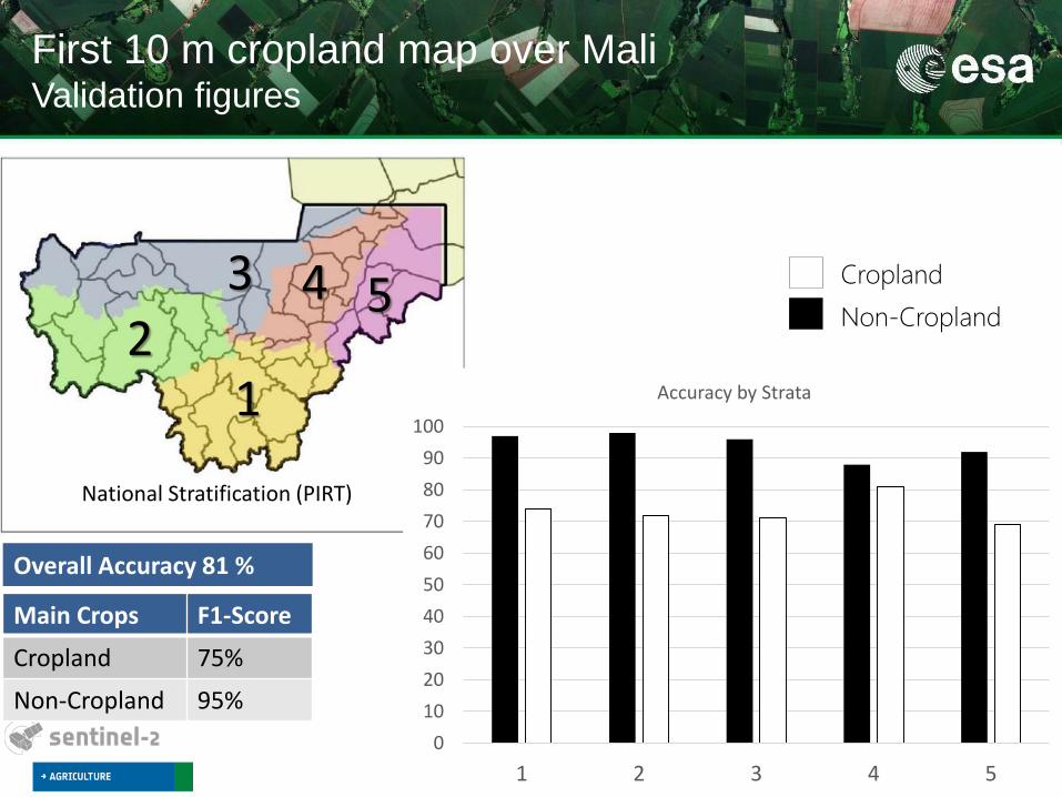
First 10 m cropland map over Mali Validation figures
Main Crops F1-Score
Cropland 75%
Non-Cropland 95%
Overall Accuracy 81 %
National Stratification (PIRT)
1 2
3 4 5
0
10
20
30
40
50
60
70
80
90
100
1 2 3 4 5
Accuracy by Strata
Cropland
Non-Cropland
Koutiala
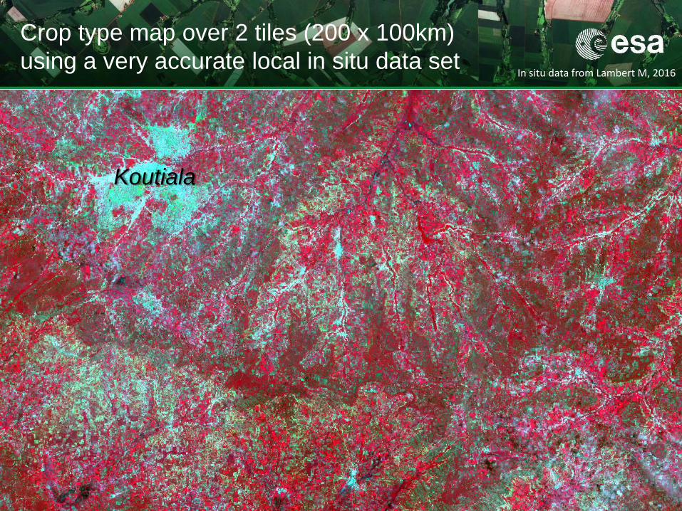
Crop type map over 2 tiles (200 x 100km)
using a very accurate local in situ data set In situ data from Lambert M, 2016

Koutiala
Crop types F1-Score
Cotton 94%
Maize 84%
Millet 77%
Sorghum 51%
Groundnuts 42%
Overall accuracy 84 %
Crop type map over 2 tiles (200 x 100km)
using a very accurate local in situ data set

17/07/2016
26/08/2016
05/09/2016
05/10/2016
25/10/2016
15/11/2016
0
1
2
3
4
Temporal series of the Leaf Area Index Koutiala region
Koutiala

Stakeholder consultation held in March in Bamako
Sen2Agri products delivered to local partners for assessment and feedbacks
75 participants including representatives from the Ministries of Agriculture and of Livestock and Fisheries and from non-governmental, public and private sectors
3 use cases where identified in consultation with the local partners
Improving agricultural statistics
Enhancing yield forecasts
Scaling agricultural insurance

Local installation of the Sen2Agri System
Sen2-Agri system transfer to Malian partner (IER) for autonomous production
Successful Installation on a dedicated server
Bandwidth challenge for the Real-Time download of the S2 and L8 data
In situ training on how to use the system
Remote support for IT

Lessons learned from the demonstration
Thanks to a close collaboration with local partners, we achieved to get the first 10-meter
resolution map of the annually cultivated area in Mali – 2016 growing season.
Sentinel-2 10 m resolution and 10 days temporal revisit frequency (S2A) bridge some of
the numerous challenges faced by cropland mapping in Sahelian regions.
Important challenge for NRT production: timeliness of the in situ data collection, transfer
and quality control
o CPS field campaign as an important source of field data: Adjustment needed in the protocol to ensure accurate geolocation of the parcels and get a homogeneous dataset
o Simplification of the typology (40 crop types et 200 crop associations) to target some crop types in priority

Mali : national demonstration paving the way for
operational use of S2 data for National Agriculture
monitoring in challenging environment
Performances assessment for national ag. monitoring based on Sentinel-2
Nationwide exploitation of temporal & spatial resolution of S2 & Landsat-8
Sen2-Agri products delivery for users assessment
Validation of the agricultural EO products from field to national scale
Strengthening Malian National Capacity for Agricultural Monitoring
Open source system supporting national monitoring and reporting
Training of IER team for in situ data sampling and on the use of the Sen2-Agri system
Sen2-Agri system transfer to Malian partner for autonomous production : Local installation and support
For what use of Sen2-Agri products by Malian and internat. decision makers ?
Identification of 3 use cases of particular interest … Ongoing work!

19/20
Thank you for your attention
© M.-J. Lambert, UCL 2017

Monitoring the 2016 growing season in Mali
with monthly National Cloud free composite at 10M over Mali
July August September October … November

Novembre 2016 50 days moving window
5/10/2016-25/11/2016
Monthly National Cloud free composite at 10M over Mali