
World Bank Document€¦ · summary of national legislation and statutory acts in the field of...
262
PROGRAM ON REHABILITATIO-- -- ' -- - -- OF THE WORLD B, El805 ENVIRONMENTAL IMPACT ASSESSMENT REPORT CLEANING OF AREAS POLLUTED WITH RADIOACTIVE WASTES AND OIL IN TERRITORY OF SABUNCHU AND SLTRAKHAI DISTRICTS OF BAKU Baku 2008 Public Disclosure Authorized Public Disclosure Authorized Public Disclosure Authorized Public Disclosure Authorized Public Disclosure Authorized Public Disclosure Authorized Public Disclosure Authorized Public Disclosure Authorized
Transcript of World Bank Document€¦ · summary of national legislation and statutory acts in the field of...
PROGRAM ON REHABILITATIO-- - - ' -- - - -
OF THE WORLD B, El805
ENVIRONMENTAL IMPACT
ASSESSMENT REPORT
CLEANING OF AREAS POLLUTED WITH RADIOACTIVE WASTES AND OIL IN
TERRITORY OF SABUNCHU AND SLTRAKHAI DISTRICTS OF BAKU
Baku 2008
Pub
lic D
iscl
osur
e A
utho
rized
Pub
lic D
iscl
osur
e A
utho
rized
Pub
lic D
iscl
osur
e A
utho
rized
Pub
lic D
iscl
osur
e A
utho
rized
Pub
lic D
iscl
osur
e A
utho
rized
Pub
lic D
iscl
osur
e A
utho
rized
Pub
lic D
iscl
osur
e A
utho
rized
Pub
lic D
iscl
osur
e A
utho
rized
** A ? & s R . m yJ5 C.... Ill .. fmo1 ....st I. .. TABLE OF CONTENTS
................................................................................................................................................................... UNTRODUCTION 7
PART 1
............................................................................................................................................................. 1 . INTRODUCTION 9
2 . PROJECT RATIONALE, AIM AND DUTlES ......................................................................................................... 10
................................................................. 3 . AIM AND DUTIES O F ENVIRONMENTAL IMPACT ASSESSMENT 12
................................................................................................................ 4 . LEGISLATION AND STATUTORY ACTS 13
4.1. SUMMARY OF NATIONAL LEGISLATION AND STATUTORY ACTS IN THE FIELD OF ENVIRONMENTAL PROTECTION ............................................................................. 13 4.1.1 National legislation .................................................................................................. 13 4.1.2 Main statutory acts ...................................................................................................................... 14
................................................ 4.1.3 International Conventions ratified in the Azerbaijan Parliament 14 4.2 SUMMARY OF NATIONAL LEGISLATION AND STATUTORY ACTS IN THE FIELD
OF THE PUBLIC RADlATION SAFETY ................... ... .................................................. 15 ..................................................... 4.3 NATIONAL REQUIREMENTS FOR EIA DOCUMENT 17
.......................................... 4.4 THE WORLD BANK REQUIREMENTS IN EIA DOCUMENT 19 ........... 4.5 NATIONAL STANDARDS AND QUALITY INDICATORS ON ENVIRONMENT 27
.................................................................... 4.5.1 Standards of Azerbaijan on environment 27
5 . SURVEY O F HISTORICAL DATA O F BAKU IODINE PLANT: ........................................................................... 29
5.1 THE HISTORY OF BAKU IODINE PLANT ...................................................................... 29 5.2 SHORT DISCRIPTION OF TECHNOLOGICAL PROCESS USED IN PRODUCTION OF
IODINE 30 5.3 PRODUCT CHARACTERlSTICS ..................................................................................... 31 5.4 SUMMARY OF TECHNOLOGICAL PROCESS ................................................................ 33
.................................................................................... 5.4.1 Production of technical iodine 33 ...................................................................................... 5.4.2 Production of reactive iodine 34
.................................................................. ............. 5.4.3 Production of potassic iodine .. 35 5.5 TREATMENT FAClLITIES ............................................................................................... 38 5.6 WATER SLIPPLY AND DRAINAGE .................................................................................. 38 5.7 HEATING SUPPLY ............................................................................................................. 43
................................................................................................................. 5.8 POWER SUPPLY 44 5.9 COMMUNICATION ........................................................................................................... 45
6 . PHYSICAL AND ENVIRONMENTAL CHARACTERISTICS ............................................................................... 46
........................... 6.1 PLACE OF LOCATION OF PRODUCTION SITES OF IODINE PLANT 46 6.1.1 Topography and geomorphology ................................................................................ 46 6.1.2 Geological characteristics ........................................................................................ 46 6.1.3 Surface and ground waters ......................................................................................... 47 6.1.3.1 Surface waters .............................................................................................................................. 47
............................................................................................................................... 6.1.3.2 Ground waters 47 6.1.4 SoiI and land-cover ................................................................................................... 49 6.1.5 Climatic conditions ................................... .... ............................................................. 49 Short description of natural climatic characteristics of the project area .................................................... 50
........................................................................................................ 6.1.6 Flora and fauna 55 ............................................................................................................................................... 6.1.6.1 Flora 55
6.1.6.2 Fauna .............................................................................................................................................. 57 6.2 AREA FOR RADIOACTIVE WASTE DISPOSAL .......................................................... 58
Aik OCrs
................................................................................ 6.2.1 Topography and geomorphology 58 ............................................................................................. 7.2.2 Geology and seismicity 58
6.2.3 Surface water and groundwater sources ...................................................................... 60 ................................................................................................................................ 6.2.3.1 . Surface water 60
6.2.3.2. Groundwater ................................................................................................................................. 60 6.2.4 Top soil ......................... .. ......................................................................................... 61 6.2.5 Flora and fauna ....................... .. ............................................................................. 61
7 . SOCIO-ECONOMIC ENVIRONMENT ...................................................................................................................... 61
7.1 POPULATION ...................................................................................................................... 61 7.1.1 Bakucity ................................................................................................................. 61 7.1 . 1 . 1 Administrative territory of Baku city ............................................................................................ 61 7.1.1.2 Sabunchu rayon ............................................................................................................................. 61
......... Some socio-demographic indicators on districts of Sabunchu rayon (beginning of 2007) 62 7.1 . 1.3 Surakhani rayon ............................................................................................................................ 66
............................................................................................................... 7.1.2 Apsheron rayon 71 7.2 HEALTH, EDUCATION, ORGANIZATION OF LABOR .................................................. 72
7.2.1 Health ............................................................................................................................. 72 7.2.2. Social provision system .................................................................................................. 74 7.2.3. Education ....................................................................................................................... 74
.................................................................................................. 7.2.4. Sport and health resort 75 7.2.5. Engagement of Local People .......................................................................................... 76 7.2.6. Labour protection, production security and safety techniques ......................................... 77
............................................................................................. 7.3 ECONOMY AND LAND USE 77 7.4 COMMUNAL SERVICES ............................................................................................. 80
7.4.1. Energy supply ................................................................................................................ 80 7.4.2. Water supply and sanitation .......................................................................................... 81
7.5 MANAGEMENT OF WASTES ....................................................................................... 82 7.5.1. Solid communal wastes (SC W) ...................................................................................... 82 7.5.2. Solid industrial wastes ................................................................................................... 83
.............................................................................. 7.5.3 Discharge of harmful matters into air 83
.................................................................................................................................................. 8 . ECOLOGICAL RlSKS 84
8.1 PRODUCTION FIELDS OF BAKU IODINE PLANT AND CONDITION OF .............................................. ENVIRONMENTAL POLLUTION IN ADJACENT AREAS 84
8.1 . 1 . Radioactive wastes ......................................................................................................... 84 8.1.1 . 1 Ramani production field ................................................................................................................ 84 8.1.1.2. Surakhani production site ........................................................................................................... 105 8.1.1.3 Conclusion ................................................................................................................................... 129 8.1.2. Oil contamination ........................................................................................................ 130 8.1.2.1. Ramani production site ............................................................................................................... 130 8.1.2.2. Surakhani production site ........................................................................................................... 132 8.1.2.3. Conclusion ............................ .. ................................................................................................ 136 8.1.3. Heavy metals .............................................................................................................. 136 8.1.4. OTHER WASTES ..................................................................................................... 145 8.1.4.1. Man-caused degraded soil and asphaltic concrete road .............................................................. 145 8.1.4.2. Construction materials and wastes as the result of destruction of buildings and constructions .. 145
8.2 CURRENT SITUATION OF POLLUTION AT THE SITE OF CONSTRUCTION OF DISPOSAL FACILITY AND IN ADJOINING TERRITORIES .......................................... 148
..................................... 9 . DESCRIPTION OF THE WORKS TO BE UNDERTAKEN WITHIN THE PROJECT 148
9.1 DISPLACEMENT PLAN .................................................................................................. 148 3

& & ~ S L P . O %+ cmna" l t~nm rnolmssra. lnc.
9.2 CONSTRUCTION WORKS ............................................................................................... 150 ...................................................... 9.2.1 Construction of burial station of radioactive wastes I50
9.2.2 Construction of support wells in Ramany manufacturing site ........................................ 150 9.3 REHABILITATION WORKS ............................................................................................. 151
9.3.1 Dismantle buildings and structures. gather. delivery and assembly construction wastes 15 1
9.3.2 Gather. delivery and burial of radioactive wastes ...................................................... 151 .................... 9.3.3 Assembly. delivery and collection of oil waste and oil poluted grounds 152
.............................................................................................. 10 . PLANNING OF REHABILITATION ACTIVITIES 154
10.1. REHABILITATION CRITERIA OF POLLUTED AREA ............................................... 154 10.2. REHABILITATION ALTERNATIVES OF THE POLLUTED AREA ............................ 156 10.3. REHABILITATION METHOD OF POLLUTED AREA . TECHNICAL AND
ENGINEERING FEASIBILITY ....................................................................................... 158 10.3.2. Neutralization of radioactive waste ............................................................................ 159 10.3.3. Neutralization of oil waste ......................................................................................... 160 10.3.4. Cleaning the production area from reiterated construction materials, garbage and technically degraded structure ............................................................................................. 161 10.3.5 Leveling of cleaned areas and provision of potentially productive and fertile top soil . . 162
10.4. EXISTING ORGANIZATIONAL AND HUMAN RESOURSES ................................... 163 10.5. EXISTING FINANCIAL RESOURCES AND CONSTRAINTS ...................................... 164
1 1 . EVALUATION OF THE ENVIRONMENTAL IMPACT OF PROJECT OUTPUTS .......................................... 166 .
1 1.1 . BACKGROUND .............................................................................................................. 166 1 1.2. ENVIRONMENTAL IMPACT OF THE REAHBILITATED AND PROXIMATE AREAS 168
1 1.2.1. Construction period .................................................................................................... 168 - .
11.2.1.1. Positive impacts ........................................................................................................................ 168 1 1.2.1.2. Negative impacts and mitigation measures ............................................................................... 168 11.2.2. Rehabilitation period ............................................................................................... 171 1 1.2.2.1. Positive impacts ...................................................................................................................... 171 11.2.2.2. Negative impacts ....................................................................................................................... 171 1 1.2.3. Post-rehabilitation period ......................................................................................... 175
11.3. ENVITONMENTAL IMPACT OF THE DISPOSAL SITE CONSTRUCTION AND DISPOSAL ACTIVITY ................. .... ........ .. .................................................................. 176 1 1.3.1. Construction period .................................................................................................... 176 1 1.3.1.1. Positive impacts ........................................................................................................................ 177 11.3.1.2. Negative impacts and mitigation measures ............................................................................... 177 1 1.3.2. Rehabilitation period .................................................................................................. 181 1 1.3.3. Post rehabilitation period ......................................................................................... 182
12 . SOCILA . ECONOMIC IMPACTS OF REHABILITATION ACTIVITIES .................................................... 182
12.1. ECONOMIC IMPACT ..................................................................................................... 182 12.2. SOCIAL IMPACTS ..................................................................................................... 183 12.3. DRIEF REVIEW OF SOSIAL IMPACT ASSESSMENT RESULTS ............................ 184
13 . ENVIRONMENTAL. RADIATION AND INDIVIDUAL SAFETY IMPACT ASSESMENT ............................... 189
13.1. ENVIRONMENTAL SAFETY OF THE POPULATION ................................................. 189 13.2. RADIATION SAFETY IN OPERATION ZONE ............................................................. 190 13.3. IlVDIVIDUAL SAFETY OF THE PERSONNEL ........................................................... 192 13.4. ACTION PLAN IN EMERGENCY CASES ..................................................................... 194
14 . SECURITY AND REACTION ACTIVITIES DURING THE TRANSPORTATION OF LOADS ....................... 196
& m s . m m y~ i.m,.ii.i r ..maar..l. c.
14.1. GENERAL INFO ............................................................................................................. 196 14.2. HAULAGE OF RADIOACTIVE WASTES ................................................................ I96
14.2.1. General requirements ............................................................................................ I96 14.2.2 Rules of defining and approval of the the transportation routes of hazardous cargo ..... 197 14.2.3 Arrangement of the movement of the motor transport transporting the hazardous cargo .
........................................................................................................................................... 198 14.3. REACTION TO FORCE-MAJOR SITUATIONS ................................... .... ................. 202
................................................................................. 15 . ENVIRONMENTAL MANAGEMENT AND MONITORING 206
15.1. ENVIRONMENTAL MANAGEMENT ........................................................................... 206 .................. 15.2. ENVIRONMENTAL MONITORING DURING THE IMPLEMENTATION 207
15.2.1. General information ................................................................................................... 207 15.2.2. Rehabilitation area ..................................................................................................... 208 15.2.3. Area for radioactive waste disposal ....................................................................... 1
16 . INSTITUTIONAL SUPERVISION AND ENVIRONMENTAL MANAGEMENT ................................................ 213
16.1 INSTITUTIONAL SUPERVISION IN THE PERIOD DURING REHABILITATION .. 213 16.2 INSTITUTIONAL SUPERVISION AND ENVIROIVMEIVTAL MANAGEMENT IN THE
PERIOD AFTER THE REHABILITATION ...................................................................... 215
17 . ENVIRONMENT MONITORING PLAN .................................................................................................................. 219
17.1 IODINE PLANTS AREA REHABILITATION COMPONEIVT .................................... 219 17.2. ENVIRONMENTAL IMPUCT MITIGATION PLAN ................................................. 223
....................................................................................................... 18 . PUBLIC PARTICIPATION IN THE PROJECT 226
18.1. ATTRACTION OF PUBLIC TO EIA PROCESS ............................................................. 226 ............... 18.2. PLANNING PUBLIC PARTICIPATION IN PROJECT IMPLEMENTATION 226
PART I1 ................................................................................................................................................................................. 228
INTRODUCTION ....................................................................................................................................................... 229
I . PROJECT JUSTIFICA TION. COALS AND OBJECTIVES .............................................................................. 230
1.1. GOAL AND OBJECTIVES ......................................................................................... 230 1.2. EXPECTED OUTCOMES ......................................................................................... 231 1.3. BENEFITS AND PRIORITIES ................................................................................... 231 1.4. PROJECT'S ROLE IN THE PROBLEM RESOLUTION ............................................. 232
2 . GOALSAND OBJECTIVES OF FRAMEWORK EIA ...................................................................................... 232
3 . ENVIRONMENTAL CHARACTERISTICS ......................................................................................................... 232
3.1. TOPOGRAPHY AND GEOMORPHOLOGY ............................................................. 232 3.2. GEOLOGICAL STRUCTURE .................................................................................... 232 3.3. GROUND WATERS ................................................................................................... 233 3.4. SOIL AND LAND-COVER ......................................................................................... 233
.............................................. 4 . ENVIRONMENTAL CONDITIONS AND CONTAMINATION ASSESSMENT 233
4.1. OIL WASTES AND OIL CONTA MINA TED SOILS .................................................... 233 4.2. RADIOACTIVE WASTE ............................................................................................ 234 4.3. OTHER TYPES OF WASTE ........................................................................................ 234
5 . PROPOSED CLEAN-UP TECHNOLOGIES AND PROJECT MILESTONES ................................................. 235
5.1. PHYSICAL-MECHANICAL TREATMENT TECHNOLOGY ....................................... 236 5.2. BIOLOGICAL TREA TMENT TECHNOLOGY ........................................................... 237
dbmsmm &* ........................ ... 5.3. PROJECT MILESTONES .......................................................................................... 238
................................................. . 6 ENVIRONMENTAL IMPACT ASSESSMENT FOR PROJECT ACTI VITIES 238
6 . 1 . POSITIVE IMPACTS ................................................................................................. 238 ....................... 6.2. NEGATIVE IMPACTS AND PROPOSED MITIGATION MEASURES 239
6.2.1. MECHANIZED WORKS ......................................................................................... 239 6.2.1.1. Air emissions ..................................................................................................................... 239 6.2.1.2. Emanation of dust ............................................................................................................. 240 6.2.1.3. Noise pollution .................................................................................................................. 240 6.2.1.4. Exogenous processes ......................................................................................................... 240 6.2.1.5. Oppression offlora and fauna .......................................................................................... 240 6.2.2. Storage of fuels and lubricants, fuelfilling .......................................................... 241 6.2.3. Industrial and municipal waste ............................................................................ 242
...................................................................................... 6.2.4. Transportation of goods 242 ........................................ 6.2.5. Environmental impact assessment of project outcomes 242
7 . PROJECT'S SOCIAL AND ECONOMIC IMPACTS ....................................................................................... 2 4 3
7.1. SOCIAL IMPACTS ..................................................................................................... 243 7.1.1. Improvement of living environment of the local population .................................. 243
................................ 7.1.2. Strengthening of the local community development capacity 243 7.2. ECONOMIC IMPACTS ............................................................................................. 243
.......................................................................................................... 7.2. I . Production 243 ........................................................................................................ 7.2.2. Employment 243
............................................................................................................ 7.2.3. Education 243 ............................................ 7.2.4. Local economic benefits and business opportunities 243
............................................................................................. 7.2.5. Budget assignments 244
ATTACHMENT I ................................................................................................................................................................ 245
ATTACHMENT I1 ............................................................................................................................................................... 250
EXECUTIVE SUMMARY ................................................................................................................................................... 250
< '/,/;,.I \'I V(, ' OF . I /t1;,1.s 1'0I.I.l:rIiI) l j '17'11 It, 4 L)I~:):t<.'T/i~ I< I f . 4.sr1.s I .V l ) 0 1 1 . .. . I \ ~' l . ' l~Kl~ 'Oh' i ' 0 1 . Y IICl \( 111' f \ I > .V/.'R.tKll.t. \:I I)/.STRI('7:S 01 I$ lK!! -
UNTRODUCTION
Territory of Ab~eron is under intensive technogenic impact related with large scale operation of oil
wells and oil and petrochemistry industry. Besides it, thousand hectares of land in Absheron, water
and sea ecosystems are polluted with oil and oil products because of extensive production methods
used before revolution without any protective measures. Mitigation of results of this pollution is
very important for the Azerbaijan Government which is going to take adecvate measures for
improvement ecological situation in Absheron peninsula. Resolution of several problems are taken
as object for "Complex Plan for improvement of ecological situation in Azerbaijan Republic for
2006-2010" approved by the Prsdiential Decree dated om September 8, 2006. Moreover, taking into
account limited financial resources the Azerbaijan Government prefer improvement of ecological
situation by stages and directs funds from the state budget and the State Oil Fund to financing of
important improvement projects such as enlargement of communication network, reconstruction of
energy forces. Though, for realization of urgent ecological projects getting of credit in this stage is
preferable. One of them is Program For Rehablitation of Absheron which is planned to be
implemented by credit of the World Bank and two pilot projects within this program. Document on
results of Environmental Impact Assessment under this projects is being discussed. They are:
"Sterilization of radioactive coal formed as the result of iodine production process in the
territory of Surakhani district" and
"Cleaning of thousand ha oil-cut area in Absheron peninsula" Projects.
The submitted document consists of two parts.
PART I
ENVIRONMENTAL IMPACT ASSESSMENT
ON
"STERILIZATION OF RADIOACTIVE COAL FORMED
AS THE RESULT OF IODINE PRODUCTION PROCESS
IN THE TERRITORY OF SURAKHANI DISTRICT"

1. INTRODUCTION
Azerbaijan Government is cooperating with the World Bank in order to achieve environmental
priorities in the field of environmental improvement and restore the environmental conditions in
Baku city and Absheron peninsular. The World Bank is planning to allocate credits for the Project
"Rehabilitation of polluted areas of Baku Iodine Plant (BIP) located on Ramany and Surakhani
settlements of Baku city" of Azerbaijan.
This report summarizes the outcomes of the Environmental impact Assessment comprising
arrangements proposed under the feasibility study project and mainly the following components:
construction of waste burial units for low active wastes;
waste removal of radioactive, oil and other contaminations in manufacturing areas of BIP;
restoration of cleaned areas and bring them into farming turnover
EIA report has been undertaken in accordance with the requirements of the effective of the
Azerbaijan Republic legislation and statutory acts on nature protection, also other World Bank acts.
Feasibility Study was designed on assessment of polluted areas of iodine plant and also
rehabilitation of polluted areas before EIA process.
Pollution assessment carried out by "Azkommunlayihe" Comunal-Design Institute comprised the
following interactive works:
review of historical materials regarding with the project area;
gather information on actual conditions of pollution of BlP manufacturing areas and
physical parameters of manufacturing buildings and structures;
suggestions on rehabilitation methods and techniques;
Evaluation of requirements on environmental, radiological and individual safety and
institutional supervision.
Feasibility Study includes the following interactive sections:
assessment of current environmental status;
planning of rehabilitation works;
rehabilitation of polluted areas;
waste management plan;

planning for emergency situations;
ensure the quality of works;
post-project instrumental supervision and management.
The present EIA is the original information source on environmental status and the given document
includes the environmental assessment of the impacts of the planned works on the surrounding
natural and social environment.
EIA document was prepared by ASP1 consulting company in conformity with the contract
concluded with "Azkommunlayihe" CDI of the Ministry of Emergencies of the Republic of -
Azerbaijan. EIA was carried out by involving national experts on respective aspects of the project.
2. PROJECT RATIONALE, AIM AND DUTIES
Contamination of Baku iodine plant, which was operational throughout the period between
1930's and 1990's, is the one of most critical environmental concerns of the Absheron peninsula.
The plant consisted of two production sites situated next to Ramani and Surakhani settlements
respectively. Neighborhood with heavily populated areas used to impose tremendous threat to a
public health when plants were operational, and continues to have its' negative impact even now
after the closure of business. The total area occupied by plant is reported to be 32.5 ha of land, 4.3 -
ha of which belong to Ramani and 28.2 ha - to Surakhani production sites.
According to practiced technologies, iodine was produced from stratal waters, which surfaced
together with oil extracted from Balakhani-Sabunchu-Ramani and Gala oilfields. These waters used --
to be transported to the accumulation reservoirs and later used as the source of iodine extraction.
Plants deployed activated charcoal as absorbents, which, among the other elements, also absorbed
different radionuclides, mainly isotopes Ra-226, Ra-228, U-235, U-238, Th-232 and K-40. In
violation of acting technical rules of the Soviet Union, the used radioactive charcoal was stored at
the production sites without proper utilization or disposal. -
Resultantly considerable volumes of radioactive charcoal waste remained in both Surakhani and -- .
Ramani facilities with the level of activity varying between 300-1,000 and 10,000-13,000 Bqlkg.
According to both national standards and International Atomic Energy Agency's (IAEA) waste -
classification scheme and guidance, the accumulated charcoal waste belongs to a category of
[Radium-Bearing] Long-Lived Low-Level Waste (LLW-LL).
& l a n : w w o y-j5 Cmnl l l t ln . t"!,l.m.r'.l.L.
Considerable contamination by abovementioned isotopes is also observed in silt and chemical
sediments deposited in the inner walls of the asbestos pipelines used for the drainage of processed
oil water. Pipelines transported the used water together with other liquid wastes back into the
reservoirs or into the neighboring industrial waste collectors, such as the Hovsan collector.
Classification of charcoal as LLW-LL radioactive waste requires that the material is withdrawn
from its' place of storage, securely packed, transported and disposed at a special near-surface
radioactive waste disposal facility. Unfortunately, no measures to isolate or dispose the charcoal
were undertaken since plants were abandoned in 1995-1996. On the contrary, due to the negligence
of plant's administration the valuable equipment and infrastructure have been disassembled and
removed from both production sites, while some parts of the remaining radioactive charcoal have
been withdrawn by third parties for reuse. Finer-grained charcoal material, subject primarily to
wind-borne transport has spread over a much wider area at the two sites, relative to the original
locations of the charcoal waste piles.
According to research data produced in 2007 by "Isotope" Special Enterprise and Institute of
Radiation Studies of the Azerbaijan National Academy of Sciences, the evaluable on-surface
volumes of charcoal waste from both sites amounted to 32,000 m3, while the level of waste's
radioactivity averaged at 15-60 microroentgens/hour, with anomaly spots reaching 600
microroentgens/hour and even more. On the other hand, according to data of "Azercommunproject"
Communal Design Institute, total volume of the industrial and other solid waste from two sites
makes up 19,000 m3, 11,000 m3 of which is due to the charcoal materials.
Due to ignorance of the required security measures, both sites used to be subject to illegal
access by third parties, mainly local residents from Ramani and Surakhani villages. Moreover, 12
IDP families (50 persons) from Garabagh region illegally settled in the administrative premises and
storehouses of the Surakhani site. All these interruptions violate the accepted security rules and
cause tremendous negative impact upon public health. Despite certain measures that have been
recently undertaken to strengthen site security and increase public awareness on relevant threats,
still the former production areas are subject to illegal public penetration and IDPs live next to the
harmful piles of radioactive waste. At the same time, it was finally managed to stop further
withdrawal of charcoal from its' storage places.
Unsatisfactory environmental conditions arisen in BIP and socio-economic development of the
regions where its manufacturing unis locate in, requires urgent measures to undertake for removal
of wastes and rehabilitation of polluted areas in order to use these areas for further use for farming
I 1
('!.,f~~C\l.%'(; ( 3 1 1 h'I:/IS POI.Ll'7SI) fJ'IP'11 H, I1)1(% IC'TlP%' M ~1.STE.Y. I Y1) OII. 1:V T/~HRlTOHJ" 0 1 , .S I H ( \'<'/If' ,l,\l).Y! I<. fKf1.l \I l)l.SFRI( XS OF'l3 lh'l
& & A i e i P m q-jT t ~ n ~ u l l l u # cmoln~.r ' , lut .
purposes. The Project "Rehabilitation of polluted areas of Baku Iodine Plant (BIP) located on
Ramany and Surakhani settlements of Baku city" is the project focusing on those matters.
The project aims at complete rehabilitation of Ramany and Surakhany manufacturing areas of BIP
considering unlimited use of those areas in farming.
The project duties are as follows:
construction of range for low active wastes;
assemble and render harmless of radioactive wastes by burying them in the range to be built;
assemble grounds polluted with oil and oil products, bitumen and black oil, deliver them to
the assigned place;
dismantle manufacturing buildings, structures, equipment, and deliver them to the assigned
place;
gather soil grounds, garbages and asphalt concrete layer and deliver them to the assigned
place;
rehabilitation of cleaned manufacturing areas and its biological productivity, hand over them
to the assigned users.
3. AIM AND DUTIES OF ENVIRONMENTAL IMPACT ASSESSMENT
Considering the duties of the project under review, the present EIA aims at proposing methods and
techniques for describing the current status of natural and social environment in the region of the
project implementation and determining environmental impact of the project outcomes and events, ~~ ~ .
minimizing the possible negative effects.
EIA duties are as follows: -
review respective national and international legislative acts;
nature of the existing natural and socio-economic environment;
summary of the field assessment works by determining environmental risks in the areas
where new range to be built and rehabilitation works to be undertaken due to the current
pollution rate;
description of the project of EIA outcomes;

& & a r ~ ~ . m q - - C l l l l l l l l , i " l l .~ . r . . l .C .
assesment of impact of the works undertaken and the project outcomes on natural and social
enironment;
prepare the environmental control and management plans during and after project duration.
4. LEGISLATION AND STATUTORY ACTS
4.1. SUMMARY OF NATIONAL LEGISLATION AND STATUTORY ACTS IN THE
FIELD OF ENVIRONMENTAL PROTECTION
4.1.1 National legislation
Nature protection legislation is implemented in accordance with the principles of the Constitution
adopted by the Republic of Azerbaijan in 1995 regarding the independence of Azerbaijan, the Law
of the Republic of Azerbaijan "On Environmental Protection", "Regulations of the Ministry of
Environment and Natural Resources" and other statutory acts and is directied to ensure the
following arrangements:
preparation and development of environmental impact assessment;
improve the existing environmental standards and raising them to European standards;
application of new economic mechanisms in order to decrease pollutions;
improve education and upbringing system;
strengthening of joint cooperation with international and regional organizations in the field
of environmental protection;
application of the principle "polluter recovers the damage";
improve environmental monitoring system.
Basis of natural protection legislation of the Republic of Azerbaijan are based on the principles of
the Constitution of the Republic of Azerbaijan adopted in 1995. As mentioned in the Constitution,
all natural resources of the Republic of Azerbaijan are the property of the Azerbaijan people. The
Constitution says that the people of the republic are bound to protect the nature and preserve its
resources. Goverment, for the sake of happiness and high wellbeing of present and future
generations, has to accept scientific basis and modern methods designed for protection of soil and
ground surface, water resources, animal and vegetable world, weather and water freshness, use
them effectively.
13
4.1.2 Main statutory acts
Here are the main nature protection legislative acts which cover all spheres of environmental
protection in the Republic of Azerbaijan:
Constitution act on the Independence of Azerbaijan (1 8 October, 199 1);
a Constitution of the Republic of Azerbaijan (12.11. 1995);
a "On Environmental protection" 8 June 1999, Ne678
a "On Environmental safety" 8 June 1999, N2677
a "On access to environmental information" 12 March 2002, N2270PQ
a "On compulsory environmental insurance" 12 March 2002
"On atmosphere weather"
a "On manufacturing and household wastes"
a "On Fishing" 27 March 1998 N2 457 - IQ
a "On specially protected natural aeas and sites" 24 March 2002, N28401Q
a "On animal world" 4 June 1999, N2675 - 1Q
"On Radioation safety"
a "On water supply and sewerage"
a Law of the Republic of Azerbaijan "On Public Health"
On certification of hazardous wastes, resolution of Cabinet of Ministers of the Republic of
Azerbaijan 3 1 March 2003
a Resolution N24 1
a Procedures of gathering, delivery and disharming of solid household wastes in living
settlements, Resolution of the Cabinet of Ministers of the Republic of Azerbaijan .-
Payment rates for use of natural resources and pollution of environment (Resolution N: 122
of the Cabinet of Ministers dated 03.03.1992).
4.1.3 International Conventions ratified in the Azerbaijan Parliament
Here are the International Conventions which were ratified in the Azerbaijan Parliament:
& d a L s ~ , m q-jF C ~ ~ S I I I I I ~ m o ~ ~ m m r s . ~ m c
UN Convention "On Environmental Impact Assessment in Transboundary context" (Espo
Convention), ratified with the Law of the Republic of Azerbaijan dated 1 February 1999.
UN Convention "On Protection of transboundary water flows and international lakes",
ratified with the Law of the Republic of Azerbaijan dated on 14 March 2000.
UN Convention "On Biodiversity Protection", ratified with the Law of the Republic of
Azerbaijan dated on 14 March 2000.
UN Convention "On access to environmental information, and the right of the public to take
part decison-making and appeal to the court", ratified with the Law of the Republic of
Azerbaijan dated on 15 February 2001.
UN Convention "On Control over delivery of transboundary wastes and their burial" (Basel
Convention), ratified with the Law of the Republic of Azerbaijan dated on 9 November
2000.
UN Convention "On Anti-Ozone Substances" (Montreal Convention), ratified with the Law
of the Republic of Azerbaijan dated on 3 1 March 1999.
Kioto Protocol to the UN Framework Convention "On Climate Change", 18 June 2000.
The mentioned documents are the new statutory acts of the independent Republic of Azerbaijan in
the field of environmental protection and use of nature. Besides these legislative documents, there
are effective Laws on weather, water, ground and others (around 20) and safety procedures applied
within the former union times and more than 50 state standards concerning the public healthcare.
Adopted Laws, Resolutions of the Cabinet of Ministers of the Republic of Azerbaijan and ratified
International Conventions on environmental protection and provision of environmental safety in the
Republic of Azerbaijan:
4.2 SUMMARY OF NATIONAL, LEGISLATION AND STATUTORY ACTS IN THE
FIELD OF THE PUBLIC KADLATICIN SAFETY
The Law of the Republic of Azerbaijan "On the Public Radiation Safety" was asserted with the
Decree 423-1Q of the President of the Republic of Azerbaijan dated on 30 December 1997, this
Law has entered into force with Decree N: 758 of the President of the Republic of Azerbaijan dated
on 19 August 1998 "On Application Procedures of the Law "On the Public Radiation Safety" in the
Republic of Azerbaijan".

* & a ; n E m m G f - 9 C ~ I I I I I I I ~ tmul leers I I ~
The Law of the Republic of Azerbaijan "On the Public Radiation Safety" has determined the legal
basis for the issues of protection from radioactive beam sources, radiation danger and public
healthcare. The Law also determines the legal basis for securing the safety when working with
radioactive substances, and other ion radiation sources by state authorities, public associations,
enterprises, organizations, and citizens of the Republic of Azerbaijan.
This Law compirses 6 chapters and 28 clauses.
Chapter 1. ((General provisions)) (1-4-th clauses).
This chapter outlines the definitons of the main notions used in the Law. The 5th Clause determines
the main principles of securing radiation safety: these are normalizing, justification and
optimization principles. The 4Ih Clause foresees undertaking the necessary arrangements required
for securing radiation safety.
Chapter 2. (5-6-th clauses).
This chapter of the Law determines the powers of the state authorities and local self-governing
bodies on securing the radiation safety.
Chapter 3. (7-12-th clauses).
This chapter determines the procedures of state governance and supervision in the field of securing
the radiation safety.
Chapter 4. (1 3-1 8-th clauses).
This chapter determines the requirements of securing the radiation safety originating from the
effects of natural radionuclids when undertaking production and use of ion beam sources, foods and
implementation of medical X-ray and radiological procedures.
Chapter 5. (19-22-th clauses).
This chapter has been dedicated to securing radiation safety in radiation accidents.
Chapter 6. (23-28-th clauses).
This chapter the rights and responsibilities of people and public unions in the field of securing
radiation safety.
& & a r a ) m q y e.m,.lfl", l",l...r.,l.c .
In conformity with the Decree N:758 of the President of the Republic of Azerbaijan "On
Application of Law of the Republic of Azerbaijan "On Radiation Safety of People" dated on 19
August 1998, and the 4th Item of the Decree N:980 dated on 23 August 2003 "On Amendments to
some decrees and orders and diseffect of some decrees of the President of the Republic of
Azerbaijan", by the Resolution N:42 dated 12 April 2004 of the Cabinet of Ministers of the
Republic of Azerbaijan, "Procedures on allowing special sanction to scientific-research and
experimental-constructor works related to use of ion beam sources", "Procedures on allowing
special sanction to design, preparation, settlement, construction, operation and taking out from
operation of structures using ion beam sources, reserve units of radioactive substances, and
radioactive stores", "Procedures on allowing special sanction to design and preparation of structures
using ion beam sources, reserve units of radioactive substances, and radioactive stores" and
"Procedures on allowing special sanction to the works related to manufacturing, processing,
delivery and use of radioactive substances" were certified.
Based on those procedures, special sanctions shall be allowed to juridical persons independent of
proper and organizational-juridical type, and also to physical persons engaged in entrepreneurship
without establishing jurudical person for 3 years by the Ministry of Emergency Situations.
Besides, in accordance with the Decree N:782 of the President of the Republic of Azerbaijan "On
the List of activities which require special sanction (license) for implementation", keeping and
buring of radioactive wastes and ioning beam sources shall be undertaken by the special sanction
(license) of the Ministry of Environment and Natural Resources.
4.3 NATIONAL KEQUlliEMENTS FOli EIA IIOCUMENT
In accordance with the currently effective legislation of the Republic of Azerbaijan, Environmental
Impact Assessment is the compulsory legal process in the design and implementation process of any
project.
The main principles of the EIA used by the Ministry of Environment and Natural Resources
(MENR) are based on the Law of the Republic of Azerbaijan on Environmental Protection adopted
in August 1999 and Regulations of the Environmental Impact Assessment Process edited in
1996 within the UN Development Programme (UNDP) (Guidelines). These Regulations include the
requirements related with the consulaltions held with scientific expertise and public. EIA document
shall be reviewed by the expert commission within three months including one month of approval
since its submission to MENR.
Environmental Impact Assessment of the the Project "Rehabilitation and cleaning of Ramany and
Surakhani manufacturing units of BIP" aims at determining the nature of the impact and the rate of
danger of all possible effects due to manufacturing and other activities on environment and poeple's
health status, evaluating environmental, economic and social consequences of this impact, and also
preventing or mitigating of the possible impacts.
The main duties arising from the above mentioned aim in the process of Environemtnal Impact
Assessment (EIA) are the following:
Environmental assessment before project, in other words, determination of primary
characteristics and parameters of the components which could possibly be affcted by the
environment;
Main factors and negative effects related to rehabilitation and cleaning works: pollution of
atmosphere air, acoustic effects, geological environmental impact, pollution of soils, surface
and underground waters,
Identification of general environmental impacts;
Preparation of recommendation and arrangements directed to limiting or decreasing of all
impact types by using new technologies, environmental protection systems etc. which
enable the protection of natural; resources;
By considering the limiting environmental factors of the foreseen activity types,
determination of the final possible indicators of effects and procedures of use of nature.
Researches undertaken within EIA were conducted in accordance with the requirements of the
nature protection legislation of the Republic Azerbaijan and particularly cover the following:
Description of the former Baku Iodine Plant Ramana and Surakhany manufacturing units
and explain of the current status of the environment in the areas where these units locate on;
Assessment of impact of the project on physical and social environment by taking i nto
account the current environmental status of BIP;
Recommendations on the arrangements directed to decreasing and mitigating these effects;
Determination of the remnant effects on the environment after the project completion.
*& a P F) I 1 q-y C..SIIII., [.Ol.l.r..l.L.
4.4 THE WORLD BANK REQlJIREMENTS IN EIA DOCUMENT
The main directives of the World Bank (WB) in the field of environmental assessment (EA) are the
Operation Policy (OP) and the WB Procedures on environmental assessment. 4.01. EA is one of 10
policies of the World Bank safety arrangements and the projects which would ask the World Bank
for the financial support should conform to the requirements of this policy. Such main policies aim
at determining potential unsatisfactory environmental and social impacts, minimizing and
mitigating them. The below ten protection policies of the WB determine basic requirements against
crediting of the Bank's projects:
Environmental assessment (OPPB 4.01),
Natural settlement environment (OPJPB 4.04),
Fighting against pests (OP 4.09),
Cultural heritage (OP 4.1 I),
Compulsory move (OPJPB 4.12),
Local population (OPIPB 4.1 O),
Forests (OPJPB 4.36)'
Dam safety (OPJPB 4.37),
Projects located on the international water routes (OPJPB 7.50) and
Projects under disputed areas (OPPB 7.60).
The first eight of these shall be reviewed within the preparatory period of EA. Here are the
extractions from respective sections of the WB Safety Policy and Procedures on environmental
assessment:
The World Bank Safety arrangements policy
You may find in internet both English and Russian versions of complete texts of the World Bank
safety arrangements policy. The below explanied extractions from the World Bank policy have been
outlined for the attantion of technical consultants to render consultations on different requirements
during environmental assessment:
OP 4.01 Environmental Assessment
EA is a process depending on the nature and scope of the given project's possible impact on
environment. Within EA, the project's potential environmental risks and their outcomes are 19
( 1.1;. I ,SI.VG or. I I < K , ~ . s 1~01.1 ,1 ,1 i f ) rrmf I L ~ DIO. f ( ' T I t 1: H . , I . S T I . S . f \-I) ( M I . I \ T I ~ U R I T O R ~ ' 0F.V I l ~ i ~ , V ~ ~ ~ I l ~ 1,Vf) .YijK,4 K l l ~ l . ~ l l) l .VTRl('T~S 01.' !< I h'i'

\-1
assessed within the area of effect, alternative options are studied under the project, and the ways of
the project selection, settlement, structure and the project implementation through minimizing
negative effects to the environment, mitigating or compensating them and strengthening positive
effects to the environment are determined. EA also includes the description of mitigation of
negative environmental effects and the control process over them during the entire period of the
project implementation. The World Bank, as much as possible, gives priority to preventive
measures rather than compensating and mitigating of unsatisfactory results. EA also foresees
natural environment (air, water and earth), people's health and safety, social factors (internally
displacement of people, local populations and cultural heritage), as well as transboundary and
environmental factors. EA reviews natural and social factors in a complex manner. EA is carried
out preferrably at the beginning of the project and it is closely incorporated with the economic,
financial, institutional, social and technical analize of the project.
1. The Bank, in order to ensure environmental safety and sustainability of the projects proposed for
funding, and to improve the decision-making process respectively, requires the environmental
assessment of these projects.
2. EA is the process depending on nature, scope and possible environmental impact of the project
the coverage, depth and analytical method of which is proposed.
In the course of EA, potential environmental risks in the project covered area and their outcomes
are assessed, alternative options within the project are studied, the World Bank, as much as
possible, gives priority to preventive measures rather than compensating and mitigating of
unsatisfactory results. EA also foresees natural environment (air, water and earth), people's health
and safety, social factors (internally displacement of people, local populations and cultural
heritage), as well as transboundary and environmental factors.
3. EA also foresees natural environment (air, water and earth), people's health and safety, social
factors (internally displacement of people, local populations and cultural heritage), as well as
transboundary and environmental factors. EA reviews natural and social factors in a complex
manner. EA also takes into account differences in the project implementation conditions and the
country-specific conditions, results of the environment-related researches in the country, national
action plans on environmental protection, general basis of the country policy, national legislation,
coordination of the project activities with the country's committments arisen from respective
international environmental contracts and agreements is taken into account. In case contradictions
are found during EA regarding between the project activities and the country's committments, the
Bank shall not fund such projects. EA is preferrably is carried out at the beginning review period of
the project and it is incorporated with the economic, financial, institutional, social and technical
analizes of the proposed project.
4. The Creditor bears the responsibility for undertaking EA. The creditor charges the EA of the
projects under the Category A to the independent experts who are out of the project. The Credit can
also involve the group of internationally accepted independent experts in order to render consulting
services on all the project aspects for the EA of the projects under the Category A, but bearing
disputable nature, and bearing great risk and multyplanned and profound environmental aspects.
'The role of the consulting group depends on the rate of preparation of the already completed
project, also work volumes and quality on EA.
5. The Bank notifies his requirements on EA to the creditor. The Bank reviews the outcomes and
recommendations of EA, and determines to what extent the funding of the project by the Bank is
based for further operation. The Bank after starting to work with the project, studies this document
in order to feel sure for coincidence of EA with the procedures described in this document in cases
the creditor completes EA fully or partially. If needed, 'The Bank may demand to undertake
additional works on EA, as well as publicity of information for wider audience and conduct public
hearings.
6 . Pollution Prevention and Abatement Handbook describes the arrangements of decreasing and
eradicating the level pollution, and also the possible level of atmosphere wastes which is considered
acceptable by the Bank. But, considering the legislation and specific conditions of the creditor
country, EA may include the recommendations on prevention and decrease of polluters and
alternative level of atmosphere wastes. EA Report should outline the complete and comprehensive
justification of selected level and approaches for the specific project or its location.
EA mechanisms
7. Depending on the project, several following mechanisms can be used meeting the requirements
of the Bank on EA: environmental impact assessment (EIA), regional or certain specific EA,
environmental auditing, assessment the ratio of danger or risk. In necessary, EA may use one or
several of these mechanisms, as well as their separate elements. If the project is supposed to
influence on separate spheres or regions, in this case it shall be required to undertake field or
regional EA.
Initial environmental assessment
&ms,mm qy? C....l,,.. E",,ln88r.,lnc.
8. In order to determine the scope and type of the necessary EA, the Bank holds the initial
enviromental assessment of each proposed project. The Bank classifies projects into the following 4
categories depending on their types, areas of implemenation, "environmental impact", scopes, and
the nature and sizes of the project possible affect on the environment:
a) Category A: If the proposed project might be able to show significant, considerable, multisided
and incredible negative effects on the environment, such kind of projects shall lie under the
Category A. Negative effects of such kind of projects exceed the project areas and sites. In the
course of the EA of the project of the Category A, potential positive and negative results of the
project for the environment are studied, these results are compared with the results of possible
alternative options (also, including the denial status from the project implementation), and also
arrangements are proposed for more effective use of environment and prevention of negative effects
on the environment, minimizing, mitigating and compensating them. The creditor shall bear the
responsibility of preparing the EIA report (or respective complex regional or field EA) which
includes elements of other documents shown on the 7th clause if required on the project under the
Category A.
b) Category V: If the project's possible negative effects makes less effects on population and
environmentally important regions, also water logging places, forests, plains and other settlements
than the projects under the Category A, these projects shall lie under the Category V. These effects
and outcomes depend on the specific area of the project, low or zero level of the irrestorable effects.
In most cases, the arrangements directed to eradication of negative effects of the projects can easily
be obtained rather than the projects under the Category A. Like in the projects under the Category
A, possible positive and negative effects of the project implementation in the course of EA are
reviewed, also arrangements are proposed for more effective use of environment and prevention of
negative effects on the environment, minimizing, mitigating and compensating them. Results of the
projects under the Category V are outlined in the project documents (the document where the
project evaluation document and the project-related information is outlined).
v) Category C: If the assumed negative effect in the proposed project is minimum, or around zero,
this project lies under the Category C and these projects don't need any activity fir further EA.
q) Category MV: If the Bank funds are directed to financing of sections of the project of possible
negative effect to the environment, in this case the proposed project shal lie under the Categor MV.
-- EA for specific type projects
Credit for certain j e l l s
9. Project coordinator or project contractor, in the design process of each section of the project of
financing of certain field investments, undertakes the EA in conformity with the policy
arrangements of this document and effective requirements of the country. If needed, the Bank
undertakes the evaluation and includes the following arrangements for capacity building of the
project coordinator or the project contracting company: a) undertake environmental assessment
separate sections of the project, b) obtain necessary experience and skills to undertake EA, v)
analyze the results on the separate specific sectons of the project, q) ensure implementing the
arangements to mitigate the effects, also, d) undertake environmental monitoring in the project
implmentation period. If the Bank decides there is not enough material-technical base for EA, in
this case all reports under the Category A, if necessary respective sections of the projects under the
Category V, and EA reports should be studied by the Bank beforehand and approved.
Credits on re-structuring of separate jelds
10. Credits for re-structuring of separate fields should meet the requirements on policy
arrangements of this document. EA on the credits for re-structuring of separate fields includes the
evaluation of the potential effects of the planned institutional and normative arrangements on the
environment.
Credits through Jinancial mediators
11. Proper EA is required for each financial mediator to undertake environmental assessment of of
separate sections of the project and subcredit for the operations. Before the project approval,
financial mediator (through its own staffs, experts or the present environmental authorities) the
separate sections of the project should meet the requirements of environmental protection fixed by
the respective local and national authorities and other respective requirements concerning with the
EA and also other requirements by the Bank.
12. The Bank, while doing the assessment of the proposed financial mediator operations, gets
acquianted with the relevance of the this country's environmental requirements appliable to the
project, the proposed arrangements on the EA for separate sections of the project, and also initial
environmental assessment mechanisms and functions and EA analyzes. If necessary, the Bank shall
ensure the inclusion the elements of strengthening of such arrangements on EA into the project.
Before the Bank assessment, each participating member of financial mediator operations should
hand over written opinion to the Bank on the financial mediator operations to be included into
& & a r ~ ~ . m C;)(:P E # l * l l l l l l C i l l l l e e r s . l l L .
separate sections of the category A of the project to undertake financial mediator operations on its
component. If the Bank decides there is not enough material-technical base for EA, in this case all
reports under the Category A, if necessary respective sections of the projects under the Category V,
and EA reports should be studied by the Bank beforehand and approved
Emergency aid principles on the rehabilitation
13. Principles under OP 4.01 are mostly applied on the emergency aid projects worked out in
accordance with "emergency aid on rehabilittion". But, if it would be difficult to effectively and
timely reach the aims, the Bank may free the project from following such policy. Such "free"
justification is affirmed in the credit documents. But the minimum requires the following: a)
emergency situations may happen in cases of disrespect of arrangements of environmental impact
and its aggravation and b) inclusion of all the required arangements for better environment into the
emergency project or into one of the future credit operations.
Institutional organization-technical base
14. If the creditor has not enough proper juridical, technical, organizational base (EA analyze,
environmental monitoring, impact mitigation arrangements etc.) in order to undertake the main
functions of EA on the proposed project, in this case the project shall include respective elements
for strengthening organizational-technical base.
Public consultations
15. The Creditor should undertake consultations with the respective population groups, local NGOs
on the environmental aspects for all the projects under the Category A and V supposed to be
financed by IDA or IADB. The creditor should organize such consultations at the beginning of the
project. The creditor should organize such consultations minimum two times on all the projects,
these are: a) immediately after undertaking initial environmental assessment and till determining the
last task of the EA and b) in the next stage after preparation of the EA report.
Besides, if necessary, the creditor shall undertake the consultations with these parties on EA and its
related aspects within the entire period of project implementation.
Publicity of information
16. The Creditor should hand over all materials described in a clear format for population groups
before consultations for environment-related consultations with the population grous and Ngos for
the projects to be financed by the IADB and IDA.

& s> R P m1 7$J? .."..I,l.. ~ ~ O t l . I , . . l . ~
7. The Creditor provides the brief description of the project aim, project profile and its possible
outcomes of the proposed project for initial consultations for all projects under the Category A; the
credit also provides brief explanation for consultations after preparation of EA report.
Besides, the creditor should enable the respective population groups and NGOs to look through the
EA report on the projects under the Category A.
18. All reports on the projects under the Category A to be financed by IDA are presented to any
relevant population group or local NGOs.
19. Creditor, after handing over the EA report on the project under the Category A to the Bank, the
Bank shall submit the English version of this document in brief to the contractors and disseminates
the document via Infoshop. If the creditor creditor protests against disseminating the EA report via
the WB Inforshop, in this the Bank staff will: a) stop the project documentation works, if its IDA
project, or b) hand over the further operation of the project to executive directors for review, if it is
IADB projec.
Porject implementation
20. Creditor shall report on the following in the course of the project implementation: a) fulfill the
arrangements agreed with the Bank on the base of EA outcomes; b) implementation of
arrangements to mitigate the results; v) on the facts identified within the monitoring. The Bank shall
realize the control over environmental factors on the base of recommendations and results of the EA
and also the arrangements shown on the juridical agreements and any other documents.
OP 4.04 Natural settlement environment
The Bank supports the nature protection through financing the projects prepared for integrating the
natural environment with local and regional development and supports more efficient use of soil.
Besides, the Bank shall assist for the rehabilitation of the degraded natural environment and
environment-related functions. The Bank shall not fund the projects with significant effect on natura
and degradation on th environment.
OP 4.09 Fight against pests
The Bank shall adhere to the strategy of decreasing the use of synthetical chemical pests and
encouraging the use of biological and environmental control methods while delivering support to
the projects of threat for agriculture or the people's health. The Bank shall demand proper
manufacturing, packing, marking, maintaining and removing of the pests which to be purhcased by
the Bank.
OP 4.11 Cultural heritage
In the United States, the term "cultural heritage" means the places of archeological, paleontological,
historical, religious and natural significance. Therefore, cultural heritage covers the remnants from
all ancient residents (sacred places and fighting areans), also unique natural places, for instance
canyons and waterfalls. The Bank shall not fund the projects of harm on the irreplacable cultural
heritage and only fund the projects directed to prevenetion of these harms.
OP 4.36 Forests
Management, protection and sustainable develpment of forest ecological systems and their
resources in rich forestry countries or limited and poor forstry countries are necessary for non-stop
poverty alleviation and sustainable development. The Bank, including adjacent natural
environment, shall not fund the forestation projects of significant environmental change and
degradation. As for the danger over the biodiversity, there should be designed the projects of
prevention and mitigation of potential danger on the environment.
The Bank shall be able to fund any activity of gathering non-wood goods of the forests carried out
by public groups or regulatory bodies of combined management of forests and small landlords, in
the following cases:
(a) this activity meets the standards of management of forests described in the paragraph 10 worked
out together with local groups, or
(b) this activity adheres to action planning of dividing into phases in order to reach such standard.
The action plan should be worked out together with local public groups and should be adequate for
the Bank.
OP 4.37 Dam Safety
The Bank shall clear out the differences between big and small dms. Normal height of small dams
shall be lower than 15 m. This category shall include farm pools, dams raising garbage and artificial
water basins. General safety procedures worked out by the skilled engineers are adequate for small
dams.
OP 7.50 Projects locating on the international water routes
The principles of operation policy shall be applied for the following type of international water
routes:
& A ~ S W I I 08 c .... Itl". t.ol.aar. I..
(a) for any river, canal, lake and similar water object between two countries, who are the members
of the Bank or any river or surface water basins located on two and more states;
b) for any river branch or surface water basins described on the above clause.
OP 7.60 Projects in the disputed areas
The projects in the disputed areas may cause to not only the relations among the countries of the
project implementation and also the Bank and its members, but also intensifying problems among
one or several adjacent countries. Any problems existing in the areas of the project implementation
should be resolved in order not to harm on th interests of the Bank or relevant countries.
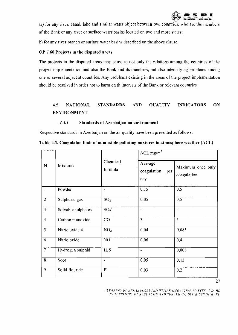
4.5 NATIONAL STANDARDS AND QUALITY INDICATORS ON
ENVIRONMENT
4.5.1 Standards of Azerbaijan on environment
Respective standards in Azerbaijan on the air quality have been presented as follows:
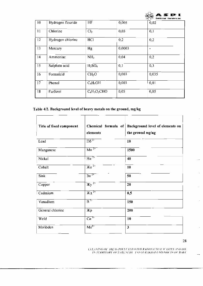
Table 4.1. Coagulaton limit of admissible polluting mixtures in atmosphere weather (ACL)
N
1
2
3
4
5
6
7
8
9
ACL mg/m3
Mixtures
Powder
Sulphuric gas
Solvable sulphates
Carbon monoxide
Nitric oxide 4
Nitric oxide
Hydrogen sulphid
Soot
Solid flouride
Average
coagulation per
day
0,15
0,05
3
0,04
0,06
0,05
0,03
Chemical
formula
SO2
sod2-
CO
NO2
NO
H2 S
-
F-
Maximum once only
coagulation
0,5
0,5
-
5
0,085
0,4
0,008
0,15
0,2 I
l l P l r i I F m m m C # I t n I I I n I 1 n O l l a a r a . l l c
10
11
12
13
Hydrogen flouride
C I2
HC I
Chlorine
Hydrogen chlorine
15
Mercury
16
HF
0,03
0,2
Sulphate acid
17
Table 412. Background level of heavy metals on the ground, mglkg
0,1
0,2
Hg
Formaleid
18
0,005
0,0003
H z S O ~
Phenol
0,02
CH20
Furfurol
Title of fixed component
0,1
CsHsOH
elements
0,3
0,003
C4H303CHO
Chemical formula of
the ground ~g l t cg
Lead
0,035
0,003
Background level of elements on
I
Nickel I Hn "
Sink 3~ 2+
0,Ol
0,05
Il6 2+
40
Cobalt
0,05
10
KO 2+
Copper
10
Vanadium
X y '+
Weld
( I I I\/\(, 0 1 lh'f I .S/ 'OI!,[ I I I> I l f f f f It I / > / < ) 1c f i r 1 11 1.SII 5 f \ i ) O i I f \ f f t ? f t ' f7ORl Oi . S j I i l \ < I f [ 1 1 1 ) 5 [ ft l h l l , g \ I / > f 5 7 R i < 1 5 O f f3 l h f
20
B 5f
Molibden
150
CH 4+ 10
M O ~ + 3
Mercury
5. SURVEY OF HISTORICAL DATA OF BAKU IODINE PLANT:
Oil products
5.1 THE HISTORY OF BAKU IODINE PLANT
u3 2+
Globally, the Chile seaweed was for a long time used as raw material for the industrial production
of iodine.75% of world's iodine used to be produced in Chile. Other iodine manufacturers (France,
Japan and Great Britain) used marine algae as input. In 1882 it was discovered that the stratal
2 8
-
waters extracted from the Absheron oil fields contains iodine and may be used as cheap and easily
available raw material for the production of industrial iodine.
100
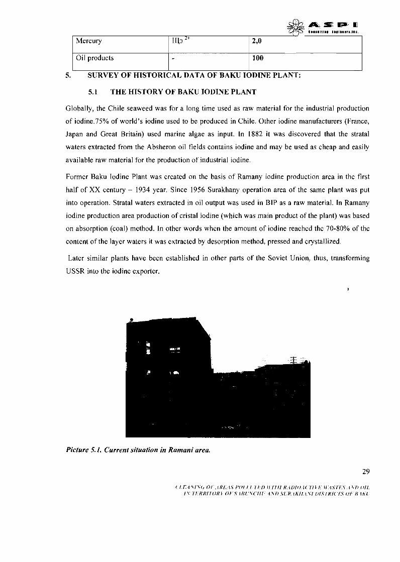
Former Baku Iodine Plant was created on the basis of Ramany iodine production area in the first
half of XX century - 1934 year. Since 1956 Surakhany operation area of the same plant was put
into operation. Stratal waters extracted in oil output was used in BIP as a raw material. In Ramany
iodine production area production of cristal iodine (which was main product of the plant) was based
on absorption (coal) method. In other words when the amount of iodine reached the 70-80% of the
content of the layer waters it was extracted by desorption method, pressed and crystallized.
Later similar plants have been established in other parts of the Soviet Union, thus, transforming
USSR into the iodine exporter.
Picture 5. I . Current situation in Ramani area.
29
*&f P . U Tf5 eanan I t Ing t n g l r s s r e . i r c .
5.2 SHOUT I~ISCRIPTION OF TECHNOLOGICAL PROCESS USED IN
PRODUCTION OF IODINE
Production of iodine at Baku Iodine Plant used stratal waters extracted by "Leninneft",
"Azizbekovneft" and "Ordjonekidzeneft" Oil and Gas Exploration Companies (OGEP). Iodine
present in stratal waters used to be extracted by the charcoal absorption method based on principle
that in the acid condition the ions of iodine get absorbed by the activated carbon. Technological
process went in the multiple open (absorbers, crystallizers, nutsch filters) and nonhermetic
(deserbers, concentrators, sublimators) cans and depended much on the manual labor.
Equipment used for pre-processing and oxidation of stratal waters, oxidation of iodides,
absorption and desorption of iodine from the active carbon used to be stored in the esplanades.
Equipment used for the crystallization, compaction, sublimation and packaging of iodine was kept
in the enclosed workshops.
Iodine production proceeded according to the below scheme:
Stratal water refined from the mechanical additions used to be supplied to the mixers and the
oxidation of iodides occurs with the addition of KMn04, C12, NaCIO, NaCIO3, KCI03, H202
or NaN02. Carbon activated in water is supplied to special absorber equipment, where
iodide-free iodine is being absorbed by the charcoal. Mixture of iodine and charcoal is
supplied to desorbers where the iodine is evaporated with the use of strong vapor and alkali
solution of sodium. Saturated solution goes to the collectors and later gets pumped into the
crystallizers. Three crystallizers in Ramani site and four crystallizers in Surakhani site have
been operational.
Solution is heated in crystallizers at the temperature of 40-50'~. Then, it is added berthollide
saline or potassium dichromate. Pending the 20 minute solution stirring the crystallizer's lid
is shut down. During the crystallization process, iodine separates in the form of fine crystals
and transforms into the paste condition when condensed. After the iodine extraction process
completes, the saturated solution is discharged into the wooden tank; deposited iodine
crystals together with saturated solution are supplied to the nutsch-filters attached to each
crystallizer. Then the iodine gets totally separated from the solution and washed by a hot
condensate. Produced paste iodine is then filled into the wooden tanks and sent to the
pressroom.
( 1 1 , 1 1 1 1 ( , 0 1 IRI 4J I'OII I 2 1 2 ) JIIIII K l l ) IO I( I l l I M k i I I 5 I\/) 011 I\ 11 t?R!lORI Of .Yl l<l \<lit 4\f) 5 i I< l h l i 111 l ~ l < l R / ~ I T 0 1 I3 i h [ -
Paste iodine is compressed by a hydraulic press equipped with oil pump. 2 presses were
installed in Ramani and 3 in Surakhani sites. Paste iodine compression in titanium shape
lasts for 1.5-2 hours under the barometric pressure of 100.
Solid iodine produced after the compression is supplied to the special tables for manual
grinding and filling into the 50 kg wooden tanks.
Cleaning of iodine from the organic and mineral compounds continues at sublimation
machines (horizontal boiler) at a temperature of 250 '~ . Then the iodine is reprocessed in the
vertical sublimators. Unloading of sublimated iodine from the sublimators' crystallizers
starts when 350 kg of iodine pass through horizontal and 800 kg pass through vertical
collectors.
After sublimation equipment cools down for about 10-12 hours, unloading of iodine from
the crystallizers starts.
12 horizontal and 7 vertical sublimation devices were installed in the Surakhani site. Filling
of iodine into sublimators and its' unloading is implemented with the use of manual labor.
Crystallization system, compression chambers and sublimation workshop were the most
unfavorable components of the production chain in terms of hygiene. These workshops operated 24
hours a day at four shifts. Concentration of iodine fumes in the workshops' airspace imposed
serious threat to the employee's health. Excessive volumes of fumes used to emit as a result of
improper leaktightness of the deployed equipment, transportation of the solution by open jets,
manual open air treatment of some of the technological processes, weak ventilation, etc.
Separation and crystallization of iodine with the use of reagents caused tremendous emissions of
violet fume which filled the entire airspace of the workshops.
Chemical reactions and continuous technological processes led to increase of the ambient
temperature and volumes of fume.
5.3 PRODUCT CHARACTERISTICS
Following three types of products used to be manufactured by Baku Iodine Plant:
Industrial half stuff iodine with following technical parameters:
Iodine - not less than 95%
Chloride and bromide - not more than 0.1%
a Organic matter - not more than 0.8%
a Red hot residuals - not more than 0.3%
Technical iodine was used for the production of drugs, artificial rubber, reagents, etc.
Reactive iodine produced and classified as "pure" according to the requirements of State
Standard 4 159-79. Parameters:
a Iodine - not less than 99.5%
a Non-volatile residuals - not more than 0.04%
a Chlorine and bromine - not more than 0.01 5%
a Sulfates - not more than 0.01 %
This type of iodine is produced as dark violet metallic crystals or pieces. Product is
used in pharmacology and chemical industry, production of some paints, video and
photo materials.
Potassic iodine produced and classified as "pure" according to the requirements of State Standard
4232-74. Parameters:
Potassic iodine - not less than 99.0%
Insoluble substances - not more than 0.02%
a Total nitrogen from nitrite, nitrate and ammoniac - not more than 0.002%
a Iodates - not more than 0.0 1 %
a Sulfates - not more than 0.01%
Chlorides and bromides - not more than 0.10%
a Barium - not more than 0.008%
a Ferrum - not more than 0.00 1 %
a Calcium - not more than 0.0 1%
a Magnesium - not more than 0.005%
a Heavy metals (plumbum) - not more than 0.001%
a Ph-I of the 5% solution of preparation - 6-9
Plant
~ m s ; : ~ m @y .... I... t nu... r ..I...
also produced potassic iodine with iodine content of not less than 99.5% (pharmacopoeia).
Potassic iodine was produced as cubic shape white, inodorous, bitter or salty crystals. Potassic
iodine is used mainly in the chemical and pharmacological industries, laboratory practice as well as
the photography and video industries.
5.4 SUMMARY OF TECHNOLOGICAL PROCESS
5.4.1 Production of technical iodine
Baku Iodine Plant produced technical iodine since 1930.
The iodine was extracted with the use of charcoal absorption method consisting in the
absorption of free iodine by the activated carbon. Iodine absorbed by the charcoal is easily desorbed
with the use of caustic soda solution, while the charcoal partly retains its' absorption capacity.
Desorbed iodine turns into readily soluble compounds. Crystallization of iodine present in these
compounds proceeds through simple crystallization of iodides.
Production capacity - 90 tonslannum.
Milestones of the production process
Processing of iodine containing stratal waters
Following processes occur when keeping stratal waters in special reservoir:
water alkalinity reduces due to the decomposition of calcium bicarbonate and deposition of
carbonate.
as a result of interaction between petroleum acids and calcium bicarbonate deposition of
insoluble calcium scum occurs.
water gets diluted through the deposition of water's mechanical impurity (sand, silt, etc.).
Oxidation of stratal water by sulfate or chloride acid
Oxidation of iodine by 5% sodium nitrate
Absorption of iodine with the activated carbon
Desorption of iodine from charcoal
Desorption of iodine from charcoal consists of two phases:
consolidation of free iodine ions with the help of alkaline solutions
washing of consolidated iodine from charcoal 3 3
V
Removal of the petroleum acids from concentrates
When alkaline concentrates get oxidized by sulfate acid with addition of sand-clay mixture,
interaction between petroleum acids and mixture leads to the absorption of acids by the partitions of
clay. Resultantly coagulation of acids takes place.
Petroleum acids impose negative impact upon the composition of final product. Therefore their
complete removal from the solution is required.
Extraction (crystallization) of iodine from the cleaned solution
Extraction of iodine proceeds with the use of bethroleum salt or potassium dichromate. Iodine goes
through the fine-grain crystallization, moves to the nutsch-filters where it is washed by water until
the neutral reaction starts.
Compression and packaging
Full nutsch-filters are placed under the press machine, where the iodine is compressed under the
atmospheric pressure of 100-350. Compressed iodine us then crumbled and packed into the wooden
boxes.
Produced technical iodine is supplied to reactive iodine and potassic iodine production facilities.
5.4.2 Production of reactive iodine
Technical iodine from Baku and partly Neftchala iodine-bromine plants were used as raw
material for the production of reactive iodine. Reactive iodine production at Baku Iodine Plant was
launched in 1940.
Production capacity - 100 tonslyear.
Production was based on the sublimation method and consisted of the following milestones:
Processing of technical iodine
Before going to a steam boiler, the technical iodine is crushed and packed into the 30-35 kg
cuvettes.
Evaporation . -
a) in the horizontal steam boilers:
Crushed and packed technical iodine is filled into the metallic steam boiler attached to a
fluoroplastic crystallizer.
LI
Boiler is heated to 2 5 0 ' ~ by electrical heaters and iodine steam enters the crystallizer. In order to
allow steam into the crystallizer, the sublimation system is attached to a natural steel-made chimney
installed on the upper lid of the catcher. Chimney itself has a lid to regulate the indraft process.
Sublimation process lasts for about 22-24 hours. During this period 300-350 kg of iodine is 13-14
times loaded into steam boiler.
After the completion of horizontal evaporation the iodine is sent to vertical steam boilers for a
secondary evaporation. Most of the organic admixtures present in the technical iodine bum as a
result of horizontal evaporation.
b) in the vertical steam boilers:
Steam boilers are heated by gas heaters to 1 5 0 - 1 8 0 ~ ~ . Then the 30 kg packs of the processed iodine
are loaded to boiler for a sublimation process which lasts for approximately 3-3.5 hours. Iodine
sublimation is implemented in a cyclic way.
Crystallization
The steam supplied to a crystallizer remains there until it becomes cool and turns into the iodine
crystals. Crystals deposit inside the crystallizer, while emerging water steam and carbon gas passes
through the catcher and gets removed by an chimney into the atmosphere.
Trapping of iodine by the metallic filings
Uncooled iodine steam passes through the chimney and enters the carefully grinded trap filled with
the metallic filings. Interaction between steam and filings produces liquid ferrum-iodine. The
produced solution is supplied to a potassic iodine site, in which it is used for oxidation of the
potassic iodine during sulfates' deposition.
Unloading from crystallizers, crumbling, weighting and packaging
Heating of vertical steam boiler stops as soon as 500-600 kg of iodine deposit in the crystallizer.
Boiler is cooled for 12-16 hours. Then the lid of crystallizer is opened and iodine gets manually
unloaded from the device. After weighting the iodine is packed into the colored glasses. 1128 kg of
the technical iodine is used in order to produce 1 ton of the reactive material.
5.4.3 Production of potassic iodine
Baku Iodine Plant started producing the potassic iodine since 1940. Production method was based
on the oxidative reaction of technical iodine with the potassium solution.
Production capacity - 90 tonslyear.
Domestically produced and imported technical iodine was used as the raw material for the
production of potassic iodine.
Production process went through the following milestones
Acquisition of oxidizing potassium
Oxidizing potassium is supplied to a workshop inside 174-1 80 kg metallic barrels. Oxidizing
potassium gets dissolved in the specially prepared solvent after the addition of certain amount of
condensate. In order to ensure synthesis 31-33% oxidizing potassium solution with the specific
weight of 1.32-1.33 is used.
Extraction of iodide-iodate compound
In order to extract iodide-iodate the technical iodine is dissolved in the 33% solution of oxidizing
potassium. For this purpose, alkaline solution is being supplied to the reactor (1250 liter capacity
equipped with turbo-mixer and covered with enamel layer). Then, for 2-2.5 hours the technical
iodine enters the rotating mixer by fixed small portions. Synthesis process is regarded completed as
soon as the residual alkalinity reaches 100-1 10 mekvll in the iodide-iodate solution.
Evaporation and drying of iodide-iodate
Without stopping of the mixer the iodide-iodate solution flows into the vacuum-exsiccant drum.
After the entire solution is settled, drum's lid hermetically closes, steam enters the drum, mixer
starts working and vacuum is being established. The steam first reaches the catcher, and then it is
directed by capacitor to a condensate accumulator.
Evaporation continues until the crystal's humidity level reaches 5%. Evaporation lasts for 16-20
hours at a pressure of 2-2.5 atmospheres.
Mixing of dry iodide-iodate with soot and melting of the produced charge
Upon completion of the dehumidification process crystals of iodide-iodate are added the soot (up to
3% of the total charge mass). For the duration of 1 hour the mixture gets stirred in a reverse mixer
and then it is unloaded to the retort for melting. Melting causes incineration of the organic
substances and reduction of iodate to potassic iodide. Retort is heated by gas and the melting
temperature reaches 8 5 0 ' ~ . Melting duration is 2-3 hours.
Dissolution of melted potassic iodine
Melted material
& %7
goes from retort to the dissolver filled with condensate. The melted mass is
dissolved while the mixer continues working.
Deposition of sulfates
Primary raw material (technical iodine, oxidizing potassium, barium carbonate) contains sulfate
solutions. Removal of sulfates requires appropriate treatment of the material. Deposition of sulfates
is obtained in the acidic medium with the help of barium carbonate produced through the addition
of ferrum iodine to the solution. Acidity should be equal to 20 mekvll. Ferrum iodine is produced
through the reaction between iodine and filings. After being heated to the 9 0 - 1 0 0 ~ ~ degree, the
oxidized solution is added barium carbonate. Upon the deposition of sulfates solution's medium
gets neutralized by the oxidizing potassium to reach the alkaline medium of 20 mekvll.
Settling and sifting of the processed solution
After deposition completes, settling of the solution proceeds for the duration of 24-36 hours. Settled
material is supplied to the nutsch-filter equipped with one layer of flannel, three layers of sifting
paper, one layer of coarse calico and one layer of cotton. Then the material gets unloaded to the
collector of pure solution.
Steaming of the potassic iodine
Filtered solution is sent to the catchers equipped with turbo-mixer and steam jacket, covered with
enamel. Steaming proceeds continuously under pressure of 2-2.5 atmospheres. Steamed continues
until the 1 : 1 relation of liquid and solid phases is achieved.
Crystallization
Steamed solution flows into the crystallization jars equipped with the jacket. Cold water is then
supplied to chill the solution. In the course of cooling crystals start settling. Cooling of jars stop as
far as the inner temperature reaches the temperature of ambient environment.
Separation and washing of parent (raw) solution, separation of crystals in the centrifuge
Main part of the parent solution goes to the raw material accumulator, while crystals remaining in
the residual are separated by centrifuge. Parent solution is checked for the presence of sulfates:
unless sulfates are discovered and alkalinity level is high the solution gets steamed and crystallized.
Otherwise the parent solution goes through the iterative processing so that the sulfates are settled
and alkalinity reaches 20 mkevll.
Drying of the potassic iodine crystals
3 7
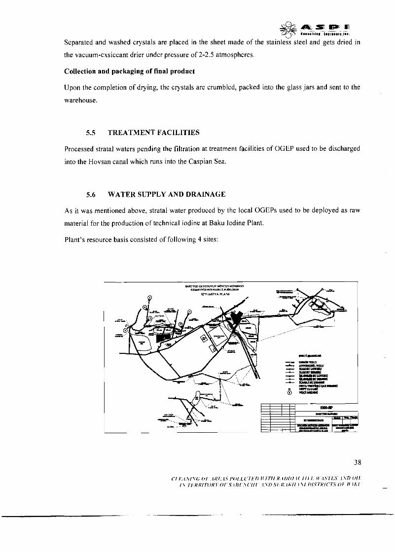
L-1
Separated and washed crystals are placed in the sheet made of the stainless steel and gets dried in
the vacuum-exsiccant drier under pressure of 2-2.5 atmospheres.
Collection and packaging of final product
Upon the completion of drying, the crystals are crumbled, packed into the glass jars and sent to the
warehouse.
5.5 TREATMENT FACILITIES
Processed stratal waters pending the filtration at treatment facilities of OGEP used to be discharged
into the Hovsan canal which runs into the Caspian Sea.
5.6 WATER SUPPLY AND DRAINAGE
As it was mentioned above, stratal water produced by the local OGEPs used to be deployed as raw
material for the production of technical iodine at Baku Iodine Plant.
Plant's resource basis consisted of following 4 sites:

Picture 5.2. Situation plan of communications of the former Iodine plant.
Ramani site:
"Leninneft" OGEP used to collect stratal waters from its' fields and directed them to the special
artificial lake by three separate lines. First line included pumping facilities #I and #2, three-section
oil remover station, lake #9 and its' injection unit. Second line consisted of three-section oil
remover station and the communication network relating station to the oil fields. The third line
included interconnected two-sectional lake # 1 1, collector connecting the lakes # 1 1 and # 12 as well
as the pumping facility #4.
Surakhani site
The site collected and processed stratal water supplied in two lines by "Ordjonekidzeneft" OGEP.
Site consisted of 5 lakes consecutively connected to each other.
Gara chukhur site
The site used to collect and process stratal waters from "Ordjonekidzeneft" OGEP. Waters were
supplied by a single line into the lakes of Surakhani site.
Azizbekov site
The site used to collect waters from "Ordjonekidzeneft" OGEP and direct them to the Surakhani
site. It included the Japaridze lake, which was divided into two sections by a set of dams, and the
pumping facilities installed to pump water to the Surakhani site.
Stratal waters used to have following parameters in terms of the iodine production perspectives:
iodine content - not less than 18-20 mgll;
alkalinity - not more than 14-16 mekvll;
temperature - +30°c - +20°c
Since oil and mechanical impurity present in stratal waters negatively affected the iodine production
technologies, raw material water first used to be kept in the oil removers so that it is cleared of the
oil, clay, silt, sand and other admixtures. There used to be one three-sectional oil remover in
Ramani and one six-sectional oil remover in Surakhani production sites. Pending the purification
procedures the water was first directed to the lake and then entered the technological process.
In 1959-1965, the resource basis of Baku Iodine Plant was reorganized and extended by a project
developed by "GIPROAZNEFT" Design Institute. Although the project envisaged the extension of
3 9
d b a s , b ~ , w cmmaaltla. t n e I n m r s , ~ m c .
stratal water supply to reach 32,000 m3 for Ramani site and 56,000 m3 for Surakhani site, the actual
supply volumes depended much on the oil production dynamics and varied during different periods
of time.
1980-1990 dynamics of the stratal water supply and discharge volumes are presented in following
table:
Table 5.1 Volume of ground waters used in former Iodine Plant during 1980-90 years
Ne Unit
measur
e
Years
1.
2.
3.
4.
5.
1980 1985
841 75 m3 of stratal water is required to produce 1 tone of the technical iodine.
6. Production plan for ton 147,3 135,l 126 126,8 121,l 103,9 102,5
Surakhani site - -------
7. Used water volume mln.m3 12,46 11,83 11,06 10,71 10,22 8,75
1986
Plant's production plan,
total
Used water volumes,
total
8.
9.
180
15,3
1987
To include:
I A. I mln.m3 12,l 10,74
Surakhani site
Note: Certain part of water used for the production process (1 0-12% of the
Discharged water
volume, total
To include:
Ramanisite
173
14,6
ton
mln.m3
Production plan for
Ramani site
Used water volume
1988
193
16,9
210,3
17,8
mln.mJ
mln.m3
180
15,8
150
1989
145
ton
mln.m3
16,19
4,78
1990
12,5
57,9
5,07
63,O
5,34
15,3
4,56
54,O
4,74
14,22
4,23
53,2
4,59
13,77
4,05
51,9
4,38
13,l
3,87
46,l
3,75
42,5
3,57
11,25
3,33
10,7
3,21
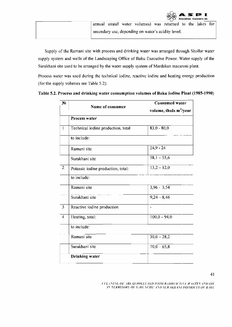
AmIsc;rp.o C V 8 b 8 l l l 8 B l l l ~ l 8 # D l b , l 8 C .
annual stratal water volumes) was returned to the lakes for
1 secondary use, depending on water's acidity level.
Supply of the Ramani site with process and drinking water was arranged through Shollar water
supply system and wells of the Landscaping Office of Baku Executive Power. Water supply of the
Surakhani site used to be arranged by the water supply system of Mardakan macaroni plant.
Process water was used during the technical iodine, reactive iodine and heating energy production
(for the supply volumes see Table 5.2):
Table 5.2. Process and drinking water consumption volumes of Baku Iodine Plant (1985-1990)
Nz?
1
2
3
4
Name of consumer Consumed water
volume, thsds m31year
Process water
Technical iodine production, total 83,O - 80,O
to include:
Ramani site
Surakhani site
Potassic iodine production, total:
24,9 - 24
58,l - 55,6
13,2 - 12,O
to include:
Ramani site
Surakhani site
Reactive iodine production
Heating, total:
3,96 - 3,54
9,24 - 8,46
-
100,O - 94,O
to include:
Ramani site
Surakhani site
Drinking water
30,O - 28,2
70,O - 65,8

1. For the subsidiary purposes, total 17,s- 16,2' '1 -
to include:
Ramani site
2 . I For communal purposes, total
8,5 - 7,7
Surakhani site
/ to include:
9,3 - 8,4
According to a historical data, plants didn't have the communal sewage system.
Surakhani site
When operational, Baku Iodine Plant used to be one of the big water pollutants in Baku. Thus, the
continuous operation of outdated and damaged water treatment facilities led to final discharge of
contaminated waste waters into the Caspian Sea. Throughout its' operation the plant was imposed
several administrative fines and economic sanctions for not meeting the environmental management
and sanitary standards. By a conclusion of environmental protection bodies, waste waters
discharged into the Hovsan canal were categorized as inadequately treated dirty waste. The
following table includes the results of analysis conducted in 1991 by Baku Sanitary-and-
Epidemiologic Service over the plant's waste water samples:
16,O - 14,2
Table 5.3 Pollution parameters of discharged waters
Indicator
PH
Smell
Transparency
Color
BPK
Related elements
Discharged Norm
6,5+8,5
2b
6mq/l
0,75 mq/l
2,6
Smaz5bm
1 1,0
sari
624
311
4,2
5b
-
boz
366
5053
Incoming
Surakhani
7,4
Smaz4bm
7,o
sari
45 8
326
Ramani
7,o
4b
0
boz
697
2 153
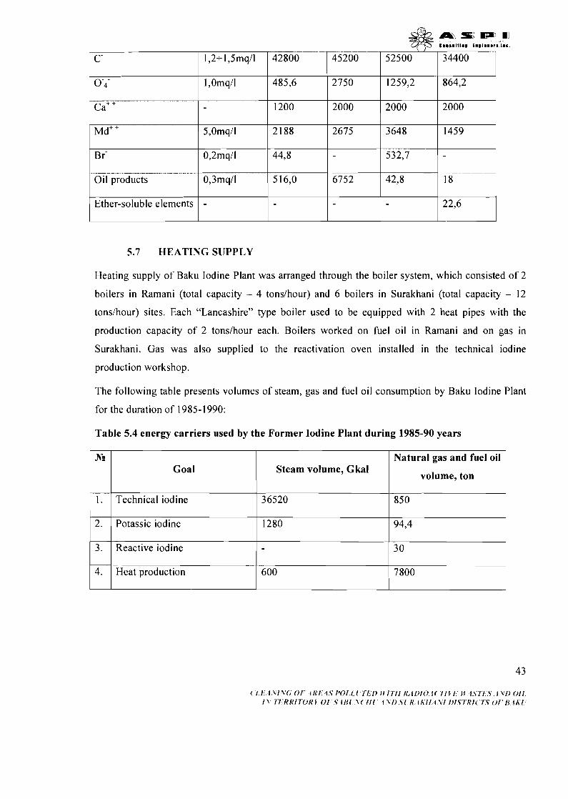
c a + +
~ d ' '
Br-
Oil products
5.7 HEATING SUPPLY
Ether-soluble elements
Heating supply of Baku Iodine Plant was arranged through the boiler system, which consisted of 2
boilers in Ramani (total capacity - 4 tonslhour) and 6 boilers in Surakhani (total capacity - 12
tonslhour) sites. Each "Lancashire" type boiler used to be equipped with 2 heat pipes with the
production capacity of 2 tonslhour each. Boilers worked on fuel oil in Ramani and on gas in
Surakhani. Gas was also supplied to the reactivation oven installed in the technical iodine
production workshop.
5,Omqll
0,2mq/l
0,3mq/l
The following table presents volumes of steam, gas and fuel oil consumption by Baku Iodine Plant
for the duration of 1985- 1990:
-
Table 5.4 energy carriers used by the Former Iodine Plant during 1985-90 years
1200
2188
44,s
516,O
22,6
2000
2675
6752
N?
1.
2.
3.
4.
2000
3648
532,7
42,s
Goal
Technical iodine
Potassic iodine
Reactive iodine
Heat production
2000
1459
18
Steam volume, Gkal
36520
1280
600
Natural gas and fuel oil
volume, ton
850
94,4
30
7800

5.8 POWER SUPPLY
Power supply of the plant was organized by "Azerenergy". Energy needs of the Surakhani site were
covered by 6 kV Gala power supply network. Ramani power supply network with the capacity of 2
kV provided energy to the second production site. Energy supply of the resource basis (2 and 6 kV)
was organized through the capacities of "Azizbekovneft", "Ordjonekidzeneft" and "Leninneft"
substations. It was reported that the substation # 043412110, 2 kV distribution network with two
210.4 transformers (respective capacities - 320 kVa and 180 kVa) as well as the substation # 455, all
supplied to the Ramani site used to be operated in the emergency condition without proper
accessibility and telephone communication.
Picture 5.3. External communications of Surakhani site
The following table describes main indicators of the plant's energy supply:
Table 5.5 Main parameters of energy provision of former Iodine Plant
Indicator WI Surakhani Ramani R e s m ~ c e I
1 I . 1 Voltage, kV I I I I - first
- second
- electric lighting 0,23
2. Electrical energy consumption volumes thsd 2840
kVt. hourlyear
- power substations over 1000V
- power substations below IOOOV
( I ! IXl\OO/ tltl 1.5 I'OllI 1 l I ) f l l l l l K LDIOl( III! M I \ J f \ 1\/ )0/1 I \ ~ ~ h ' R I l O R 1 0 1 .TI!$( \ ( / I ! ~ \ / ) 5 ~ R ~ h / l i \ ! / ) ~ ~ ~ R ! ~ / $ O f 8 t h {
6
0,410,23
-
2
0,410,23
2 va 6
0,410,23

5.9 COMMUNICATION
a s D ) m C l l l l l l l l l t U O l l l b l t I I L .
Until 1985 year Ramani site of the plant was connected to city ATS, Surakhani site was connected
to Ramani site with one connection line. Only in accordance with the project prepared in 1985 year
telephone cable for 20 phone numbers was layed from ATS #20 located in Amirjan settlement to
the enterprise.
According to the order #I57 of State Property Privatization Department of the Ministry of
Economical Development of Azerbaijan Republic from 29 April 2002 ((11 State Program for
privatization of state property in Azerbaijan Republic", the Law 208 IQ of Azerbaijan Republic
from 29 November 1996 about "Rules and Regulations for conversion of state enterprises into joint
stock companies", Decree #648 of the President of Azerbaijan Republic "About privatization of
chemical industrial enterprises and organizations" from 22 March 2001 year the capital of Baku
Iodine Plant under ((Azerkimya)) State Company located in Baku city, Sabunchu district,
Musabekov street was determined as 1014840000 (one billion fourteen million one hundred and
fourty thousand) manats and "Baku Iodine" Joint Stock Company was established.
3.
For many years World Bank (WB) playing a role of a main international donor in financing the
projects connected with roads, water and gas supply and other infrastructure and environmental
issues. One of the important components in all those projects is improvement of environmental
safety and stable social development. The WB mission visited Azerbaijan recently and offered to
Azerbaijan Government the next environmental project in connection with solid waste treatment,
cleaning the soil polluted with oil in Absheron peninsula and cleaning the former iodine-bromine
production sites from radioactive coal and asbestos wastes and rehabilitation of these areas, as well
as financial and technical support in this regard. Beside WB IAAE is also interested in rehabilitation
and cleaning of the area of former BIP.
Number and capacity of transformers, MVAIunit.
35/6kV
6/0,4 kV va 2/0,4 kV
( I , I . A \ I X C , 01' 1 1 { 1 , 4 . ~ 1 ~ 0 1 . 1 , ~ I ~ I ) I I I I I I R , ~ I ) I O i ( I / L ~ H i . s r 1 . s I \ I ) ~ I I I \ I t K K 1 I Y ) K I O I ' S 4 H 1 , %( f I 1 4 2 1 ) Y l K l h l l l XI I ) f S I K I ( ' I C O I ' R l h l
1,42
6/0,4 va
2/0,4
2,14
6/0,4
0,5
2/0,4
& & m s s m ?1$5 c c a r r l t l n r t n ~ ~ ~ m m m r s . ~ ~ ~ .
6. PHYSICAL AND ENVIRONMENTAL CHARACTERISTICS
6.1 PLACE OF LOCATION OF PRODUCTION SITES OF IODINE
PLANT
6.1.1 Topography and geomorphology
Generally, the landscape of both production sites is characterized as flat, tectonic and subject to
erosion processes.
Ramani site is situated on the southwestern slope of drainless hollow that has emerged on the
southeastern extension of the Surakhani anticlinal swell as a result of Holocene erosion-abrasion
processes. Hollow's bottom is flooded by an artificial lake created by discharge oil waters from the
nearby oil fields. Former production site is situated on leveled platform on the lake's southwestern
bank. Platform is inclined towards the lake and has absolute altitudes of - m. Surakhani site is
situated on the western extension of Bina-Hovsan abrasive-denudation plain with slightly
undulating micro-relief. Due to the landscape conditions, precipitation forms temporary water
flows, which drain towards the flat drainless hollow partly filled with discharge oil water and
situated 250-300 m to the site's south-west, on the other side of one-track railway. Site itself is
located on a leveled platform with absolute altitude of - m, gently inclined in the northeast
direction.
6.1.2 Geological characteristics
Both former production sites are situated within the articulation belt of Surakhani anticline with
Bina-Hovsan mould.
Ramani site is located directly on flat northeastern extension of the Surakhani anticline, formed of
detritus limestone, sands and clays of the middle-Absheron Eopleistocene sublayer. Outcrops of
these sediments are unconcordantly overlapped by the horizontally bedded limestone and sands of
the Khazarian layer of mid-Quaternary (Middle Pleistocene) sediments (thickness - 2-10 m).
According to drilling data, the section of Khazarian layer is composed of technogenically
contaminated sabulous soil (thickness - 0.5-1.1 m) and underlying pale grey limestone sands.
Surakhani site is situated on the southwestern extension of Bina-Hovsan flat brachial syncline
(mould) which is composed of the Eopleistocene-Golocenic sediments. Within the site boundaries,
horizontally bedded Khazarian sediments from middle Pleistocene (thickness - up to 30 m) come to
a surface. Layer is composed of the thin alternation of fine-grain sands, limestone sands, limestone
46
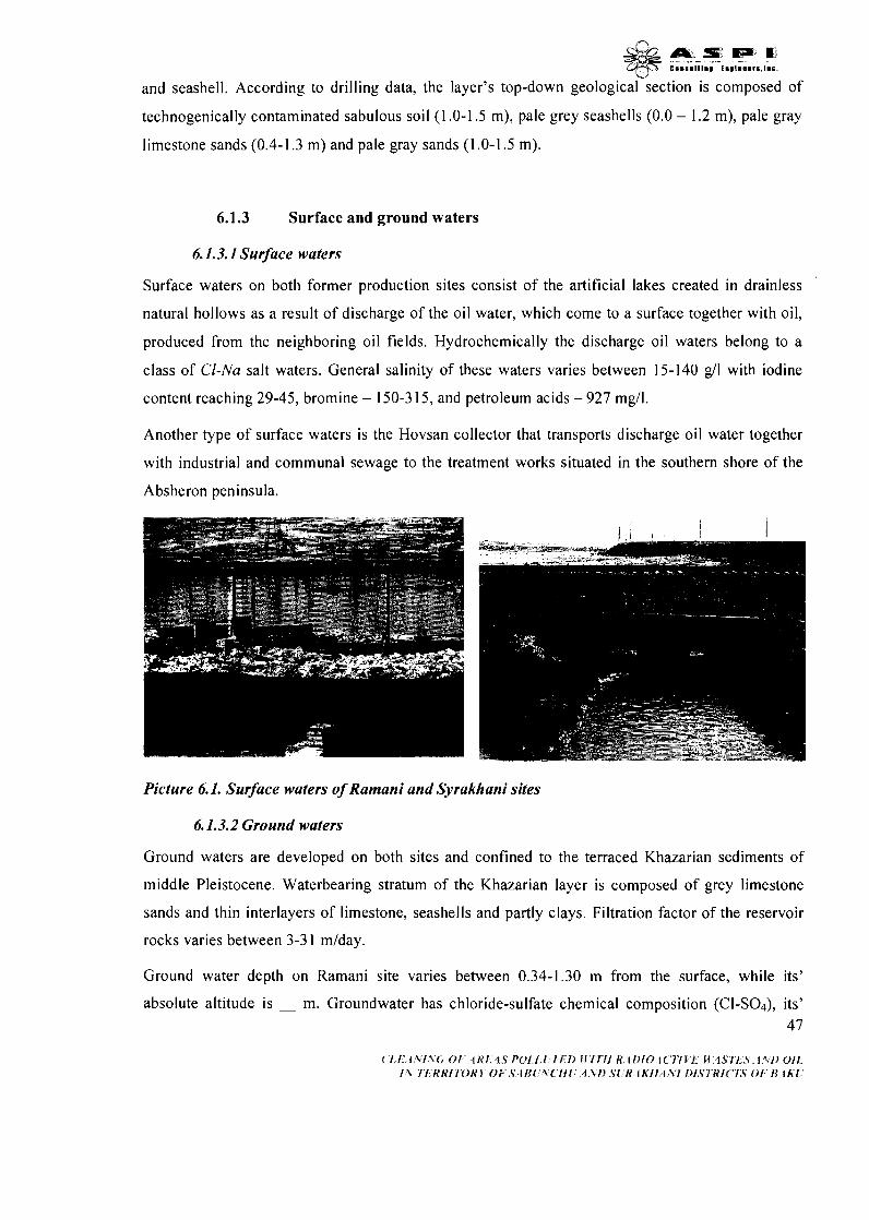
and seashell. According to drilling data, the layer's top-down geologica~~section is composed of
technogenically contaminated sabulous soil (1 -0-1 -5 m), pale grey seashells (0.0 - 1.2 m), pale gray
limestone sands (0.4-1.3 m) and pale gray sands (1 -0-1.5 m).
6.1.3 Surface and ground waters
6.1.3.1 Surface waters
Surface waters on both former production sites consist of the artificial lakes created in drainless
natural hollows as a result of discharge of the oil water, which come to a surface together with oil,
produced from the neighboring oil fields. Hydrochemically the discharge oil waters belong to a
class of Cl-Nu salt waters. General salinity of these waters varies between 15-140 g/l with iodine
content reaching 29-45, bromine - 150-3 15, and petroleum acids - 927 mgll.
Another type of surface waters is the Hovsan collector that transports discharge oil water together
with industrial and communal sewage to the treatment works situated in the southern shore of the
Absheron peninsula.
Picture 6.1. Surface waters of Ramani and Syrakhani sites
6.1.3.2 Ground waters
Ground waters are developed on both sites and confined to the terraced Khazarian sediments of
middle Pleistocene. Waterbearing stratum of the Khazarian layer is composed of grey limestone
sands and thin interlayers of limestone, seashells and partly clays. Filtration factor of the reservoir
rocks varies between 3-3 1 mlday.
Ground water depth on Ramani site varies between 0.34-1.30 m from the surface, while its'
absolute altitude is - m. Groundwater has chloride-sulfate chemical composition (CI-SO4), its' 4 7
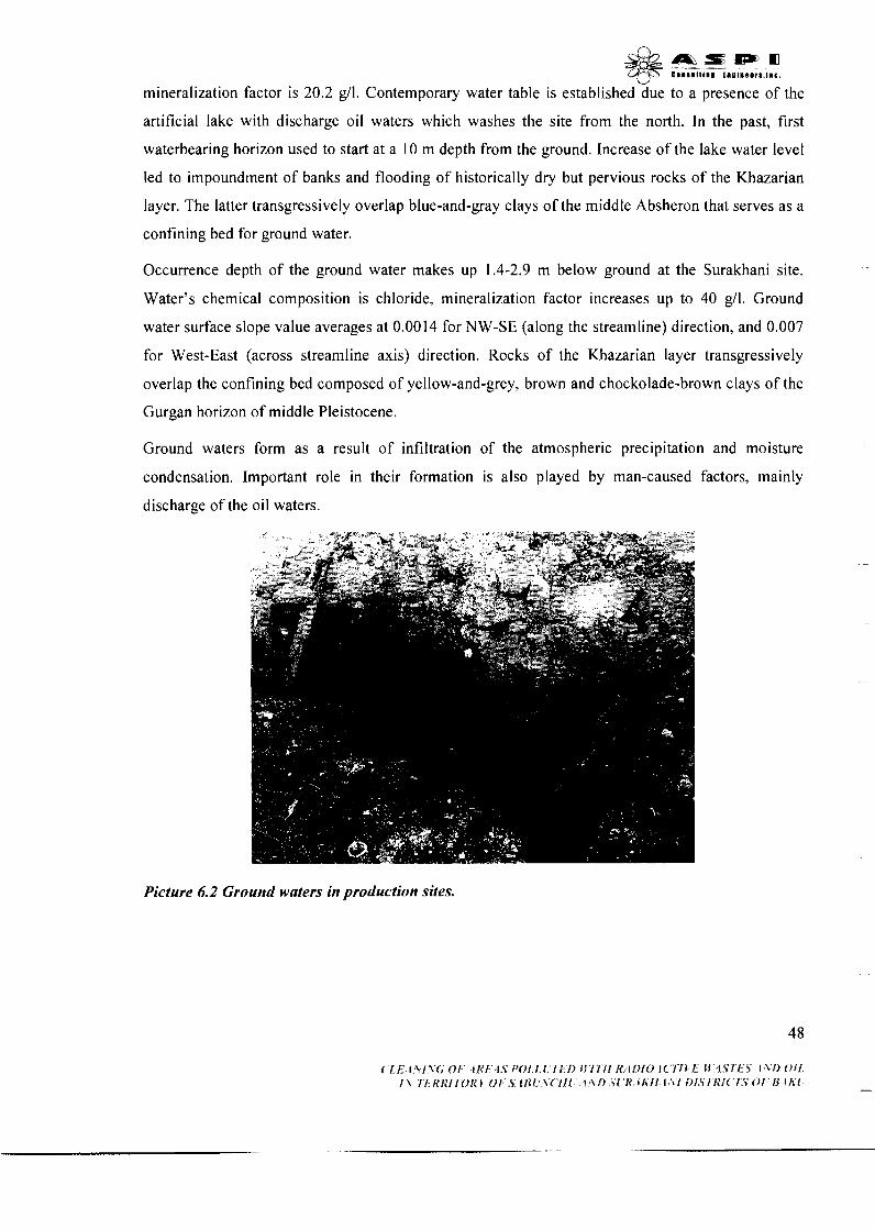
mineralization
d b a s w r n qF C O . S l l t l l # E l l @ l R ~ ~ r S . l l c .
factor is 20.2 g/l. Contemporary water table is established due to a presence of the
artificial lake with discharge oil waters which washes the site from the north. In the past, first
waterbearing horizon used to start at a 10 m depth from the ground. Increase of the lake water level
led to impoundment of banks and flooding of historically dry but pervious rocks of the Khazarian
layer. The latter transgressively overlap blue-and-gray clays of the middle Absheron that serves as a
confining bed for ground water.
Occurrence depth of the ground water makes up 1.4-2.9 m below ground at the Surakhani site.
Water's chemical composition is chloride, mineralization factor increases up to 40 g/l. Ground
water surface slope value averages at 0.0014 for NW-SE (along the streamline) direction, and 0.007
for West-East (across streamline axis) direction. Rocks of the Khazarian layer transgressively
overlap the confining bed composed of yellow-and-grey, brown and chockolade-brown clays of the
Gurgan horizon of middle Pleistocene.
Ground waters form as a result of infiltration of the atmospheric precipitation and moisture
condensation. Important role in their formation is also played by man-caused factors, mainly
discharge of the oil waters.
Picture 6.2 Ground waters in production sites.

6.1.4 Soil and land-cover
Soil cover is absent at the territory of two production sites. Observed only are the outcrops of
sabulous ground contaminated with different waste and debris. Soil of the surrounding territories is
composed of sandy-loams and sierozem.
Dislocation territories of former iodine plants are known for their ephemeral semi-desert verdure,
cycle of which conforms to the annual variation of the precipitation. Different orchards and melons
are grown at the homestead lands owned by the local population.
Picture 6.3. Bitumised sites.
6.1.5 Climatic conditions
Regional climatic conditions were identified according to the data of meteorological stations
situated close to the production sites of former Baku iodine plant. Climatic conditions of the area
are given in the tables 3.1-3.3.
Area is characterized by arid subtropic climate with higher average annual temperatures.
Air temperature Average annual temperature of the Absheron peninsula is +14' C, average monthly
temperature constitutes + 3 . 9 ' ~ in January and +35.7 '~ in July.
d b a s p m -29 c.. '.ltl.. ~".l"eer'.l.c.
Maximum temperatures of +37 - + 4 2 ' ~ are registered in August, while the minimum temperatures
of -8 - - 1 2 ' ~ are registered in January.
Humidity Humidity of the peninsula is mainly dependent on the atmospheric circulation processes.
Thus, during the wintertime atmospheric moisture capacity makes up 71-8096 as subjected to the
penetration of cold air masses with relatively high humidity level. During summers, the atmospheric
moisture capacity reduces to 46-66% as a result of penetration by hot and dry air masses.
Atmospheric moisture capacity stabilizes at 60-75% during spring and autumn times.
Average annual humidity for the peninsula, therefore, makes up 62-70%.
Atmospheric precipitation Atmospheric precipitation in the peninsula happens mainly due to the
penetration of cold air masses and averages at 250 mm per annum.
Maximum precipitation (60-70 %) occurs during the cold seasons and makes up 144 mm.
Precipitation levels decrease during the hot seasons and total at 106 mm.
Maximum monthly precipitation levels are indicated in November (43 mm) and April (29 mm),
while the minimum levels are registered in July and August (5-6 mm).
Due to the peninsula's high average temperatures, precipitations mainly occur in the form of
rainfalls. However, during winters the precipitation falls mainly in the form of snowfalls while the
duration of snow cover reaches 8-10 days in average.
Short description of natural climatic characteristics of the project area
Table 6.1. Meteorological characters and factors determining the distribution of atmospheric
pollutants
NAMES OF FEATURES
. ? 5 'Aver f
"01th I k North-East
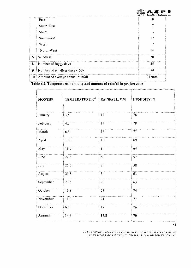
South-East i 7 <
i
1 South a 3
I South-west 3
West 1
14 q North-West -
; 6 Windless
- - - ."-+
Table 6.2. Temperature, humidity and amount of rainfall in project zone *-"*--. --**+--
1 I
RAINFALL, MM
January
February
April
August
September 21,5
- " - - December

Table 6.3. Change of speed by wind directions
WIND DIRECTION
North
North-East
East
South-East
South
WIND SPEED, MISEC
0- 1
2-5
6-10
11-15
More than 15
0- 1
2-5
6-10
11-15
More than 15
0- 1
2-5
6- 10
11-15
More than 15
0- 1
2-5
6-10
11-15
More than 15
0- 1
DURATION, %
5
8
9
4
3
2
3
Short
1
Short
3
3
1
Short
Short
3
4
1
Short
Short
5

South-West
West
North-West
Wind direction
More than 15
I
More than 15 1 0,5
More than 15
11-15
More than 15
Short
More than 15 7,5
I
Total 100%
86% of total precipitation observed in the peninsula is up to the rainfalls, 8% fall in the form of
sleets. while 6% occur as the snowfalls.
Cloudiness Cloudiness of the contaminated sites is mainly predetermined by frontal and regional
circulation processes as well as the region's orographic characteristics.
Open and cloudless weather prevails on the peninsula due to the dominant anticyclone processes.
During the warm hot seasons, the cloudless days constitute 45-80% of the monthly weather record.
During cold seasons average monthly share of the cloudy days increases to 50-75%.
Fogs Fogs mainly consist of the condensation materials accumulated in the atmosphere. Presence of
these materials reduces horizontal visibility up to lkm. Fogs are observed since October until April
with most foggy periods in February-March (22 days). Fogs mainly occur at the seaside areas and
last for 10- 12 hours at an average. . ...
Storms Storms mainly occur during the hot seasons and cover the period of May through August.
Storms are often accompanied by heavy showers, strong wind and sometimes hail. Average annual
number of stormy days is five, and the maximum number is 19 for the Absheron peninsula.
Winds Strong north winds prevail on the peninsula and constitute 38% of the total windy days.
Breeze and northwesterly winds are more seldom and make up 19% and 17% of the total windy
days respectively. Share of the other winds varies between 2-8%.
During cold seasons, the shares of north, northwesterly and breeze winds constitute 35, 20 and
2 1% respectively. The share of north winds increases to 45%, while the chare of other winds remain
unchanged during hot periods.
Average wind speed in the Absheron peninsula varies between 5 m/s (40%), 6-9 m/s (30%) and
15 m/s (20%). Winds with the velocity of 20-25 m/s blow 15-22 days per year. Winds equal and
over 30 m/s are rare and blow 3-6 days per year.
During the winter and spring observed are the fion (sea-borne) winds that lead to the increase in the
air temperature of the peninsula.
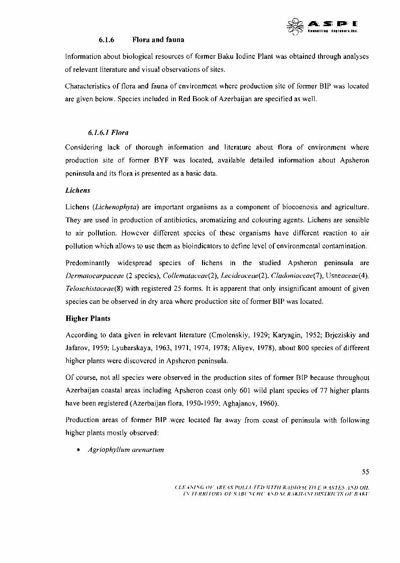
6.1.6 Flora and fauna
Information about biological resources of former Baku Iodine Plant was obtained through analyses
of relevant literature and visual observations of sites.
Characteristics of flora and fauna of environment where production site of former BIP was located
are given below. Species included in Red Book of Azerbaijan are specified as well.
Considering lack of thorough information and literature about flora of environment where
production site of former BYF was located, available detailed information about Apsheron
peninsula and its flora is presented as a basic data.
Lichens
Lichens (Lichenophyta) are important organisms as a component of biocoenosis and agriculture.
They are used in production of antibiotics, aromatizing and colouring agents. Lichens are sensible
to air pollution. However different species of these organisms have different reaction to air
pollution which allows to use them as bioindicators to define level of environmental contamination.
Predominantly widespread species of lichens in the studied Apsheron peninsula are
Dermatocarpaceae (2 species), Collemataceae(2), Lecideaceae(2), Cladoniaceae(7), Usneaceae(4),
Teloschistaceae(8) with registered 25 forms. It is apparent that only insignificant amount of given
species can be observed in dry area where production site of former BIP was located.
Higher Plants
According to data given in relevant literature (Cmolenskiy, 1929; Karyagin, 1952; Brjeziskiy and
Jafarov, 1959; Lyubarskaya, 1963, 197 1, 1974, 1978; Aliyev, 1978), about 800 species of different
higher plants were discovered in Apsheron peninsula.
Of course, not all species were observed in the production sites of former BIP because throughout
Azerbaijan coastal areas including Apsheron coast only 601 wild plant species of 77 higher plants
have been registered (Azerbaijan flora, 1950- 1959; Aghajanov, 1960).
Production areas of former BIP .were located far away from coast of peninsula with following
higher plants mostly observed:
Agriophyllum arenartum
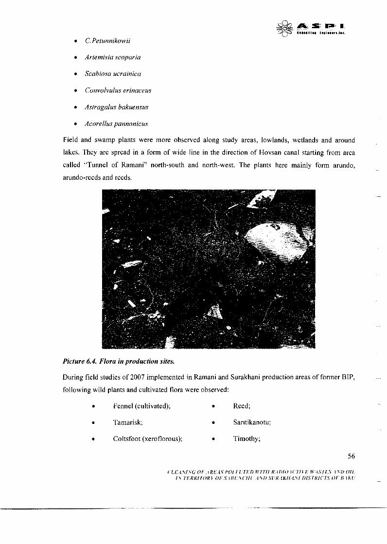
a Artemisia scoparia
a Scabiosa ucrainica
Convolvulus erinaceus
a Astragalus bakuensus
Acorellus pannonicus
Field and swamp plants were more observed along study areas, lowlands, wetlands and around
lakes. They are spread in a form of wide line in the direction of Hovsan canal starting from area
called "Tunnel of Ramani" north-south and north-west. The plants here mainly form arundo,
arundo-reeds and reeds.
Picture 6.4. Flora in production sites.
During field studies of 2007 implemented in Ramani and Surakhani production areas of former BIP, -
following wild plants and cultivated flora were observed:
• Fennel (cultivated); • Reed;
• Tamarisk; • Sar~tikanotu;
• Coltsfoot (xeroflorous); • Timothy;

Oleaster;
Orach;
Fig;
Cocksfoot;
Aconite;
Goat's-beard;
Cilotu;
Came 1's-thorn;
Pomegranate;
Zaragan;
Knotweed;
Syrian hibiscus;
Willow.
It should be noted that following plants observed close to the study area of Apsheron peninsula
were included in the Red Book of Azerbaijan:
Piliform stipa. Spread only in Apsheron peninsula (Buzovna, Shuvelan, Mardakan) in the
sands of coastal area.
Oat grass. Spread only in Apsheron peninsula - in the sands of Baku coastal area.
Palestinian Sandpiper. Spread only in Apsheron peninsula - in Mardakan, Shuvelan, Bina,
Zira, Artyom Island and coastal sands.
Iris. Spread only in Apsheron peninsula - in Mardakan, Shuvelan, Gara Chukhur, Bulbule
Lake, Zigh village and Yasamal lowland.
Caucasus orchis. Spread only in Apsheron peninsula, between rocks of middle mountainous
range, where plenty green grass is observed.
Candlestick Bur grass. Spread in Apsheron peninsula - Yasamal lowland of Baku, rough
saline sandy areas.
Cultivated Plant
Fruit trees such as grapes, fig, mulberry, quince, pomegranate, apricot, peach, almond, and olive
typical for Apsheron peninsula are planted in individual settlements and households within the area
production of former Baku Iodine Plant and especially in Ramani production area. Moreover long
sides of highways are composed of cypress trees, pine trees, willow tree, plane tree, olive tree and
oleaster trees and evergreen bush with white and red flowers -oleander plant.
6.1.6.2 Fauna
57
Amphibian
According to data from relevant books (Alakbarov, 1978) there are only two types of amphibian
registered in Apsheron peninsula:
Batrachians - Salienta
Green land frog - Bufo viridis
Lake frog - Rana ridibunda
Reptiles
According to analyses of relevant books (Domrovskiy, 19 13; Jafarov, 1949; Alekberov, 1973, 1978;
Aliyev, 1974; Aliyev and Shirinova, 1989) following types of reptiles were registered in Apsheron
peninsula in recent years:
Tortoise
Caspian tortoise - Mauremis caspica
Mediterranean tortoise - Testudo graesa (this type is entered in the Red Book of Azerbaijan).
6.2 AREA FOR RADIOACTIVE WASTE DISPOSAL
6.2.1 Topography and geomorphology
Area for burying radionuclide wastes will be selected in accordance with flat relief, tectonic
features, and etc. Intensive formation of foothills, erosion of surface, and other natural impacts
forming small swampy areas are considered relevant for construction of such area. Construction site
is situated in the north-east slopes of Govun mountain (327,6 m), with total area of 35-40 thousand
m2, absolute elevation 100-150 m with flat surface and slopeness.
The area is covered by foothills in the north-west and south-east, while in the north-east direction
from north of Govun, Gizilaji and Boyukdagh it is covered by range of hills forming "amphitheatre"
of 0,09 slope. Its relief allows formation of temporary water streams during rainfall. These streams
flow in the direction of Sumgayit-river bed situated 1.5 km from site.
7.2.2 Geology and seismicity
The construction site is situated in the north, north-east corner of anticline turned to south of Govun
Mountains. Anticline of Govun Mountains is formed from lower roofs of Govun suite of eosen
period and corners of middle and top layers. 5 8
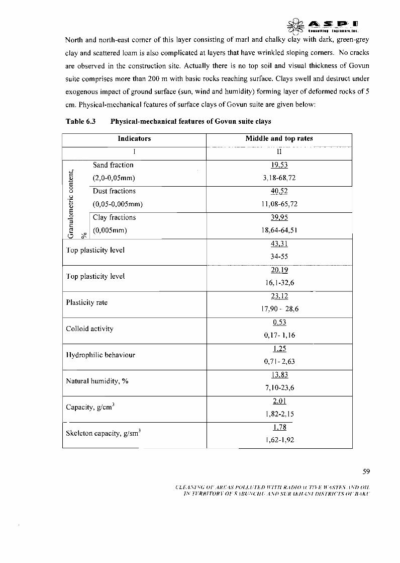
,a,,,,. qy.T c.. S.l,l.. E . . l l l l r S , l l c .
North and north-east corner of this layer consisting of marl and chalky clay with dark, green-grey
clay and scattered loam is also complicated at layers that have wrinkled sloping corners. No cracks
are observed in the construction site. Actually there is no top soil and visual thickness of Govun
suite comprises more than 200 m with basic rocks reaching surface. Clays swell and destruct under
exogenous impact of ground surface (sun, wind and humidity) forming layer of deformed rocks of 5
cm. Physical-mechanical features of surface clays of Govun suite are given below:
Table 6.3 Physical-mechanical features of Govun suite clays
Middle and top rates
I1
19,53
3,18-68,72
40,52
11,08-65,72
39,95
18,64-64,5 1
43,3 1
34-55
20,19
16,l-32,6
23,12
17,90 - 28,6
0.53
0,17- 1,16
1.25
0,71- 2,63
13,83
7,lO-23,6
2.01
1,82-2,15
1,78
1,62-1,92
Indicators
I
Y"
5 Y c 0 o 0 . - L, Y : 0 - =I C 2 0 s
Sand fraction
(2,O-0,05mm)
Dust fractions
(0,05-0,005mm)
Clay fractions
(0,005mm)
Top plasticity level
Top plasticity level
Plasticity rate
Colloid activity
Hydrophilic behaviour
Natural humidity, %
Capacity, g/cm3
Skeleton capacity, g/sm3
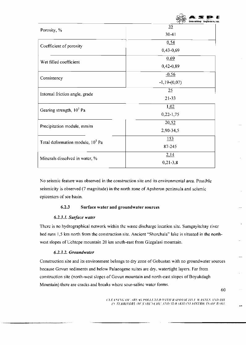
\ I
Wet filled coefficient
Porosity, %
Coefficient of porosity
Consistency
35 -
30-4 1
0,54
0,43-0,69
Internal friction angle, grade
Precipitation module, mm/m
2 5 -
21-33
Gearing strength, lo5 Pa 1,02
0,22-1,75
Minerals dissolved in water, %
Total deformation module, lo5 Pa
No seismic feature was observed in the construction site and its environmental area. Possible
seismicity is observed (7 magnitude) in the north zone of Apsheron peninsula and seismic
epicenters of see basin.
153 87-245
6.2.3 Surface water and groundwater sources
6.2.3.1. Surface water
There is no hydrographical network within the waste discharge location site. Sumgayitchay river
bed runs 1,5 km north from the construction site. Ancient "Shorchala" lake is situated in the north-
west slopes of Uchtepe mountain 20 km south-east from Gizgalasi mountain.
6.2.3.2. Groundwater
Construction site and its environment belongs to dry zone of Gobustan with no groundwater sources
because Govun sediments and below Palaeogene suites are dry, watertight layers. Far from
construction site (north-west slopes of Govun mountain and north-east slopes of Boyukdagh
Mountain) there are cracks and breaks where sour-saline water forms. 60
6.2.4 Top soil
There is no top-soil in the area allocated for construction of polygon to discharge and burry
radioactive wastes. The area is characterised by 10 cm brown clay soil.
6.2.5 Flora and fauna
Flora is rather poor in the construction site and its surrounding area. Its mainly characterised by
annual ephemeral grass plants and scattered sagebrush in spring. The fauna of the area is
characterised by invertebrate animals (ant, spider, beetle, scorpion and etc.), reptiles (lizard, snake)
and rodent (field rats).
7. SOCIO-ECONOMIC ENVIRONMENT
7.1 POPULATION
7.1.1 Bakucity
7.1.1. I Administrative territory of Baku city
'The capital of Azerbaijan Republic is the biggest city in Caucasus region. Being a big industrial,
cultural and scientific centre Baku is also a biggest port city in Caspian sea basin. Baku is divided
into Greater Baku and two parts as a city centre. Greater Baku is situated in 2000 km2 area
including entire Apsheron peninsula and agglomeration covering oil fields and sea. In addition to
central city Greater Baku includes 46 districts and 19 villages.
Modern Baku - is a big industrial centre which includes big oil and gas industries and oil-chemical,
mechanical engineering, metal manufacturing, light industry and food industry and etc.
Baku city consists of 11 administrative rayons: these are Sabail, Sabunchu, Yasamal, Nerimanov,
Nesimi, Khatai, Binegedi, Surakhani, Ezizbeyov, Garadagh and Nizami rayons. From geographical
point of view Apsheron rural rayon also enters into territory of Greater Baku. However, this rayon
is defined as separate administrative zone because of dominating agricultural engagement. Ramani
and Surakhani production areas of former BIP enter into administrative zones of Sabunchu and
Sukharani respectively.
7.1.1.2 Sabunchu rayon
Sabunchu rayon is situated in the north-east of Apsheron peninsula. The total area of rayon is 24,O
km2. There are 10 residential settlements in the rayon. These are: Sabunchu, Bakikhanov,
Balakhani, Bilgeh, Zabrat, Kurdekhani, Mashtagha, Nardaran, Pirshaghi and Ramani districts.
There are 40 middle and big industrial enterprises, 46 preschool educational enterprises, 44 6 1

L/
secondary schools, 8 hospitals and clinics, and 4 big cultural objects. According to 2007 data from
State Statistical Committee of Azerbaijan Republic total population of Sabunchu is 199513 of
which 49,20% are male and 50,80% are female. Of total population 58,4% (1 8-60 age) are working
able people. Majority of population live in settlements established during middle ages or before.
Number of refugees sheltered in Sabunchu is 83 18 while of internally displaced is 17456.
In connection with intensive development of oil and gas industry in the last 60-70 years, small rural
settlement engaged in different works and agriculture expanded and became larger.
Population growth of these rayons is connected with urbanization process and natural growth of
local inhabitants.
In connection with collapse of Soviet system and breakout of Garabagh conflict in 1990, decrease
of industrial production in Sabunchu and Surakhani rayons as in other rayons of Republic,
termination of economic relations caused unemployment, flow of youth and especially male into
neighbour regions and countries to earn living, large emigrations and replacements within the city
conglomeration.
Main factors impacting ecological condition of Sabunchu rayon are ongoing pollution of soil from
oil and oil related production, and location of BIP Ramani production site, and Balakhani urban
landfill in this area. Moreover, South Canal, Romani Tunnel and Hovsan Canal which are known as
main polluters of Caspian Sea run through the rayon area. Present negotiations between Ministry of
Emergency Situations, Ministry of Economic Development, State Oil Company and World Bank
and studies conducted by private companies to cope the problem give basis to make good hopes
about future ecological condition of Sabunchu and Surakhani rayons.
Some socio-demographic indicators on districts of Sabuncku rayon (beginning of 2007)
Table 7.1. Number of population, natural growth, marriages and divorces (man)
Marriage
1961
Name of districts
Sabunchu rayon -total
Including:
Divorce
271
Natural growth
Total
2153
Number of population
Total
199513
including:
male
1163
Including:
female
990
male
98174
female
101339
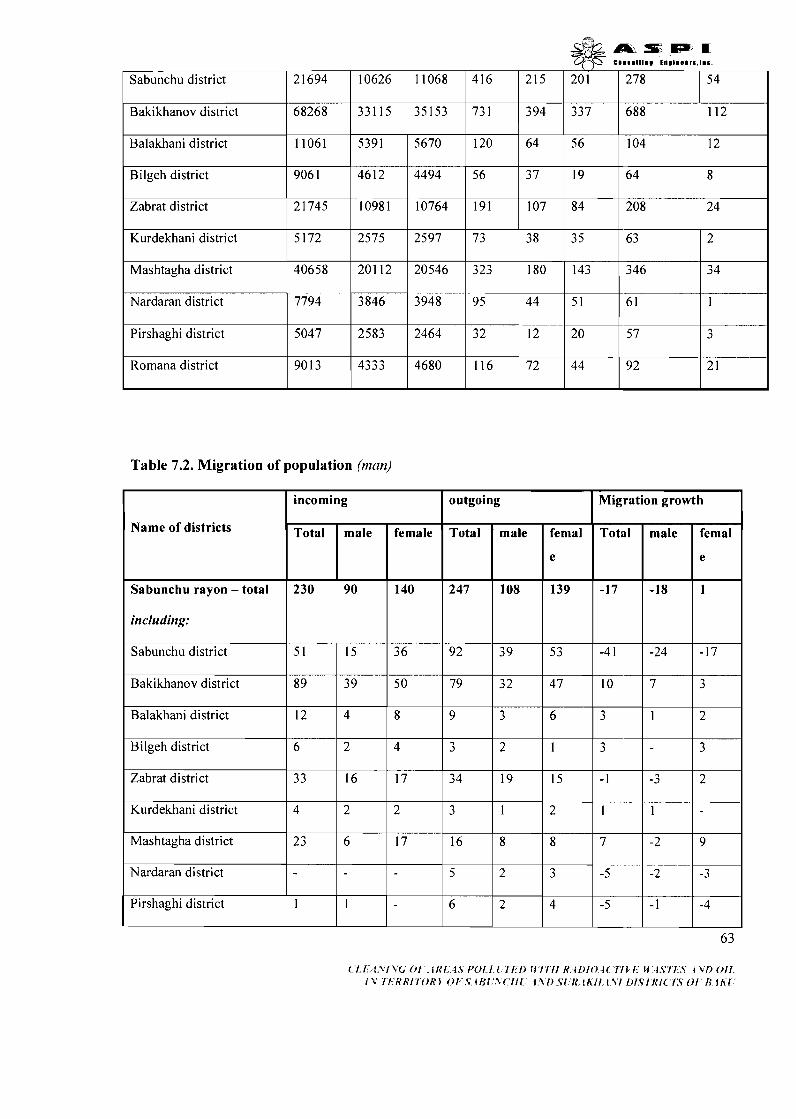
_ss-3,msmPa q'3s e ...Dl... ......a,..
Sabunchu district 21694 10626 11068 416 215 201
Bakikhanov district 68268 331 15 35153 731 394 337
Balakhani district 11061 5391 5670 120
Bilgeh district
Zabrat district 21745 10981 10764 191 107 84
Kurdekhani district 5172 2575 2597 73 38 35
Mashtagha district 40658 201 12 20546 323 180 143 346 3 4
Nardaran district 7794 3846 3948 95
Pirshaghi district
Table 7.2. Migration of population (man)
Romana district
5047
90 13
Name of districts
Sabunchu rayon - total
including:
Sabunchu district
Bakikhanov district
Balakhani district
Bilgeh district
Zabrat district
Kurdekhani district
Mashtagha district
Nardaran district
Pirshaghi district
2583
4333
2464
incoming
4680
Total
230
5 1
8 9
12
6
33
4
2 3
1
32
outgoing
116
male
90
15
39
4
2
16
2
6
1
Total
247
92
79
9
3
3 4
3
16
5
6
Migration growth
12
female
140
36
50
8
4
17
2
17
Total
-17
-4 1
10
3
3
- 1
1
7
-5
72
male
108
39
32
3
2
19
1
8
2
2
20
femal
e
139
53
4 7
6
1
15
2
8
3
4 -5
male
-18
-24
7
1
-3
1
-2
7 44
femal
e
1
-17
3
2
3
2
9
92 2 1
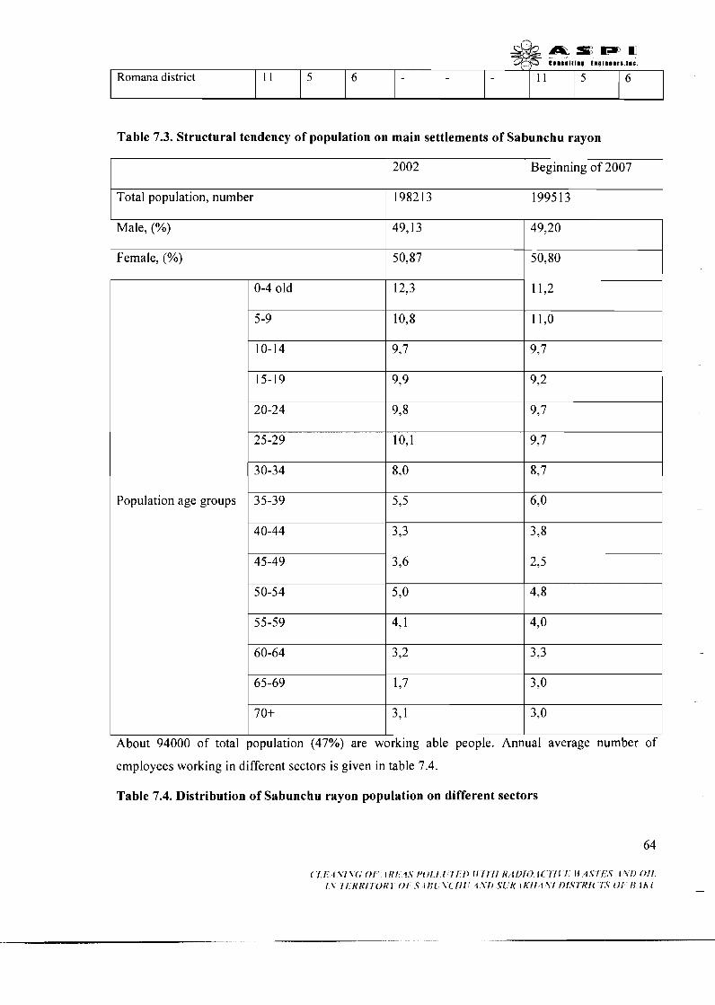
Table 7.3. Structural tendency of population on main settlements of Sabunchu rayon
A i : S m P ) U e ~ m s a ~ ~ t m u tno ln88rs . lmc
Romana district
2002
11
Beginning of 2007
Total population, number
Male, (%)
5
198213
Female, (%)
I I I
About 94000 of total population (47%) are working able people. Annual average number of
199513
49,13
Population age groups
employees working in different sectors is given in table 7.4.
6
49,20
50,87
Table 7.4. Distribution of Sabunchu rayon population on different sectors
50,80
20-24
25-29
30-34
35-39
11
9,8
10,l
8,o
5,5
5
9,7
937
8,7
6,o
6

& a s a n Y-fX emnamlllma t m ~ ~ m m e r s . ~ m c .
Agriculture 71
I Sector of economic employment
Industry
Transport 100311
Average annual 1 21947
Communication 8341 1 Construction 8778-1
Trade 8142-1 Health and social protection (542(11
I Culture
1 Science
1 Management
Total number of employees 72506
In the production sector 1
439 10
Non-production sector 28596 I 16 and older students
I Total number of working able people I 94400 I
11851
House workers
Residential Settlements of Sabunchu rayon close to BIP production site
10043 1
Ramani is situated in the north-east coasts of Apsheron peninsula 18 km from Baku city. According
to 2007 data its population makes up 9013 people. No data available about precise formation age of
this district. Plates made of clay and brick walls found during archaeological investigations carried
out in 1960-70 prove ancient inhabitants living in this area. Significant changes are clearly seen in
this district since 1950 when new schools, kindergartens, and residential buildings were built.
According to decree No 1008 dated 27 February 2006 of President of Azerbaijan on "Program of 6 5
measures
& & m s m , , q - - c e l ~ l l t l l . I " ~ ~ ~ I ~ . . I I C
on acceleration of socio-economic development of districts of Baku city" renovation of
Ramani infrastructure began to take place as in other districts and villages of Sabunchu rayon. In
order to improve gas supply 109 and 2 19 mm 2880 plm gas lines were constructed in 2004-2007,
internal streets and roads repaired in Ramani. Reconstruction of 11013516 kV ctzabrat)) electric
substation of Sabunchu rayon has significantly improved electricity supply to Ramani district.
Private houses constructed without relevant infrastructure in the north-west and north-east of district
in recent years are only several meters distance from BIP Ramani production site. Radioactive coal
brought by wind, pollution of private farming from contaminated materials washed by rain,
pasturing in the area of iodine plant and other factors show big risks to health of people living in
neighbouring settlements.
Though rehabilitation of BIP production area situated close to Ramani district under "Program of
measures on acceleration of socio-economic development of districts of Baku city" was entrusted to
Sabunchu Rayon Executive Authority however EA of Sabunchu rayon has applied to Cabinet of
Ministers of Azerbaijan Republic to help them clean and rehabilitate the environment from
radioactive coal because of limited local capacity in this sphere.
7.1.1.3 Suraklzani rayon
Surakhani rayon is situated in the centre of Apsheron peninsula covering area of 10,O km2. There
are 6 districts in the rayon. These are: Bulbule, Garachukhur, Amirjan, Zigh, Yeni Surakhani and
Hovsani districts. There are 23 middle and big industrial enterprises, 34 preschool objects, 30
secondary schools, 6 hospitals and clinics, and 4 big cultural centres. According to statistic data of
State Statistic Committee of the Republic of Azerbaijan number of Surakhani population for 2007 is
177488 of which 48,75% are male and 5 1,25% female. Of total population 57,20% (1 8-60 age) are
working able people. Majority of population live in districts built in middle centuries and before.
Number of refugees sheltered in Sabunchu is 8430 while of internally displaced is 14901.
BIP Surakhani production site is situated close to New Surakhani district of rayon.
Surakhani faces same ecological problems in connection with similar geographical position and
industrial fields and infrastructure.
Number of population, natural growth, gender proportion, indicators of migration and other
demographic parameters of big residential settlements of Sabunchu and Surakhani rayons are given
in the below tables:
66
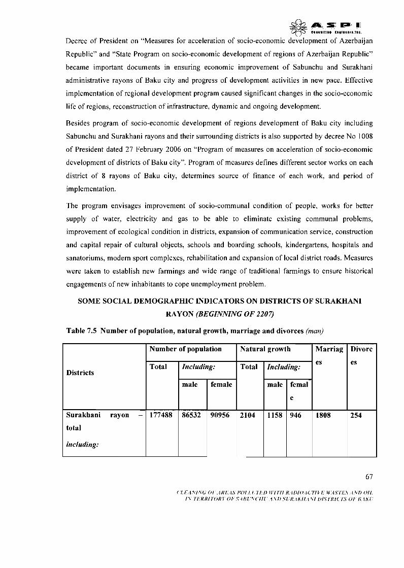
& a r m= MI q-J5- e o n s n l ~ ~ n m t n ~ ~ n a a r s , ~ n c .
Decree of President on "Measures for acceleration of socio-economic development of Azerbaijan
Republic" and "State Program on socio-economic development of regions of Azerbaijan Republic"
became important documents in ensuring economic improvement of Sabunchu and Surakhani
administrative rayons of Baku city and progress of development activities in new pace. Effective
implementation of regional development program caused significant changes in the socio-economic
life of regions, reconstruction of infrastructure, dynamic and ongoing development.
Besides program of socio-economic development of regions development of Baku city including
Sabunchu and Surakhani rayons and their surrounding districts is also supported by decree No 1008
of President dated 27 February 2006 on "Program of measures on acceleration of socio-economic
development of districts of Baku city". Program of measures defines different sector works on each
district of 8 rayons of Baku city, determines source of finance of each work, and period of
implementation.
The program envisages improvement of socio-communal condition of people, works for better
supply of water, electricity and gas to be able to eliminate existing communal problems,
improvement of ecological condition in districts, expansion of communication service, construction
and capital repair of cultural objects, schools and boarding schools, kindergartens, hospitals and
sanatoriums, modem sport complexes, rehabilitation and expansion of local district roads. Measures
were taken to establish new farmings and wide range of traditional farmings to ensure historical
engagements of new inhabitants to cope unemployment problem.
SOME SOCIAL DEMOGRAPHIC INDICATORS ON DISTRICTS OF SURAKHANI
RAYON (BEGINNING O F 2207)
Table 7.5 Number of population, natural growth, marriage and divorces (man)
Districts
Surakhani rayon -
total
including:
Number of population
Total
177488
Natural growth Marriag
es
1808
Total
2104
Including:
Divorc
es
254
male
86532
female
90956
Including:
male
1158
femal
e
946
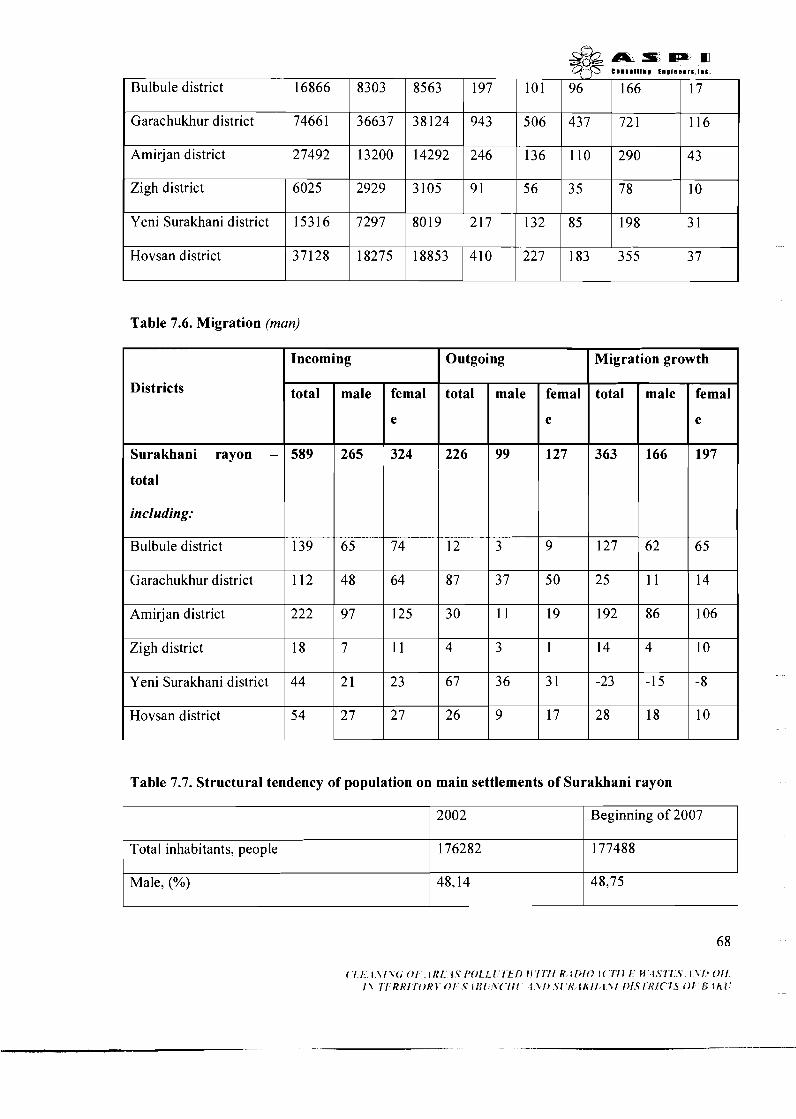
Bulbule district
Garachukhur district
Amirjan district
Zigh district
Table 7.6. Migration (man)
Yeni Surakhani district
Hovsan district
16866
74661
27492
6025
Table 7.7. Structural tendency of population on main settlements of Surakhani rayon
15316
37128
Districts
Surakhani rayon -
total
including:
Bulbule district
Garachukhur district
Amirjan district
Zigh district
Y eni Surakhani district
Hovsan district
8303
36637
13200
2929
( 1 1 I \ / \ < , 0 1 I/{/ l s r J o l f 1 I f f ) f f / / ! / I< I/>fO I ( I l t f H 1.511 'l [\!> 011 1 1 11 K K I l O K l 0 1 .s i f f1 lc I \!I ' l i i t lhI / / l ' l / /> /SIRf( 1 s 0 1 !5 f i i i
8563
38124
14292
3105
7297
18275
Total inhabitants, people
Male, (%)
8019
18853
Incoming
total
589
139
112
222
18
44
5 4
2002
176282
48,14
Outgoing
Beginning of 2007
177488
48,75
male
265
65
48
97
7
2 1
2 7
total
226
12
8 7
30
4
67
26
Migration growth
femal
e
324
74
64
125
11
23
2 7
total
363
127
2 5
192
14
-23
2 8
male
99
3
37
I I
3
36
9
femal
e
127
9
50
19
1
3 1
17
male
166
62
11
86
4
-15
18
femal
e
197
6 5
14
106
10
-8
10
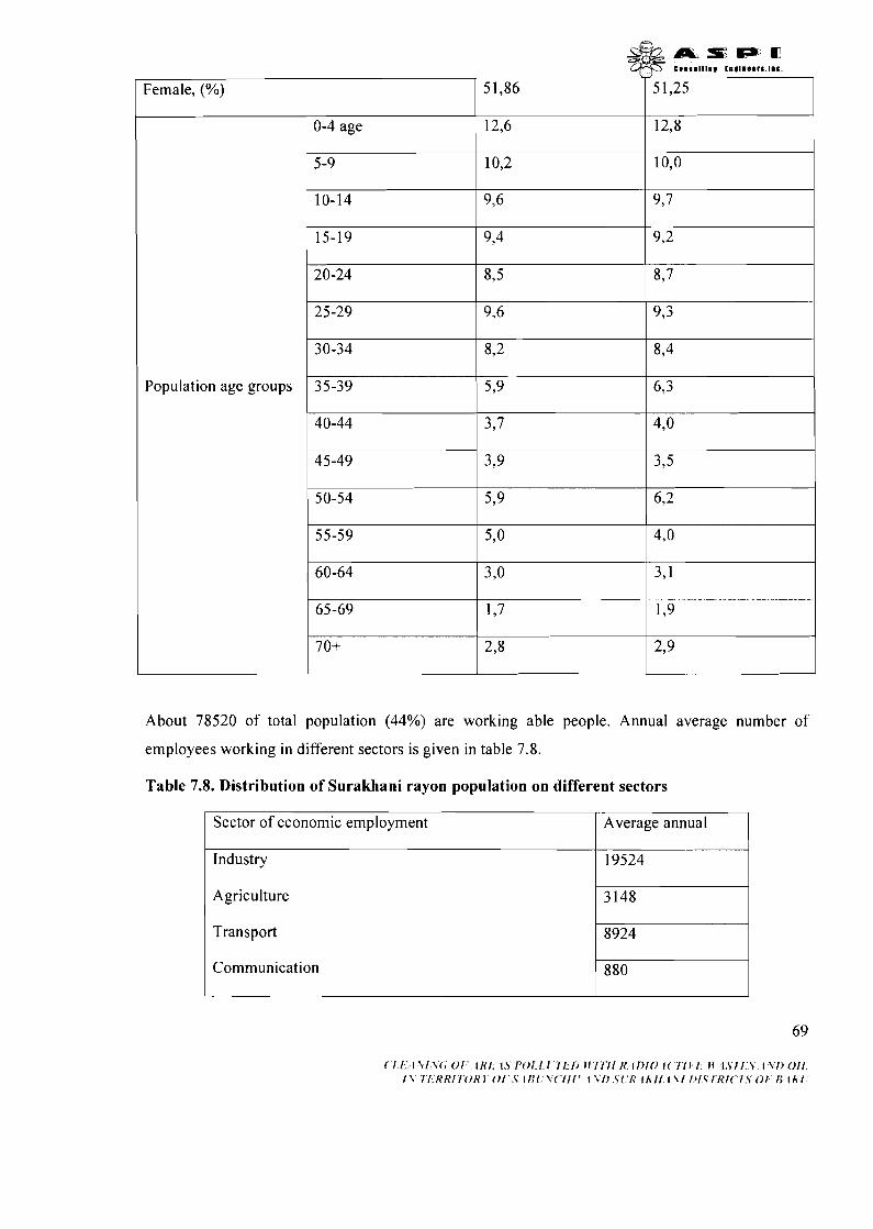
A L s m m ,;;~IIIR~ t n g ~ n a e ~ s . ~ m c ,
Female, (%) 51,86
0-4 age 12,6 I
Population age groups
About 78520 of total population (44%) are working able people. Annual average number of
employees working in different sectors is given in table 7.8.
Table 7.8. Distribution of Surakhani rayon population on different sectors
Sector of economic employment
Agriculture 3148-1 Average annual
Industry
Transport p%rP1 19524
Communication
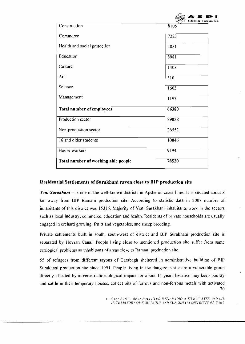
I Commerce 1 7223
Health and social protection
Education 8981~ Culture 1408
1 Science
Management 1193~ I Total number of employees I 66380 I I Production sector I 39828 I Non-production sector 26552
16 and older students
I Total number of working able people I 78520 I
10846
House workers
Residential Settlements of Surakhani rayon close to BIP production site
9 194
Yeni-Surakhani - is one of the well-known districts in Apsheron coast lines. It is situated about 8
km away from BIP Ramani production site. According to statistic data in 2007 number of
inhabitants of this district was 15316. Majority of Yeni Surakhani inhabitants work in the sectors
such as local industry, commerce, education and health. Residents of private households are usually
engaged in orchard growing, fruits and vegetables, and sheep breeding.
Private settlements built in south, south-west of district and BIP Surakhani production site is
separated by Hovsan Canal. People living close to mentioned production site suffer from same
ecological problems as inhabitants of areas close to Ramani production site.
55 of refugees from different rayons of Garabagh sheltered in administrative building of BIP
Surakhani production site since 1994. People living in the dangerous site are a vulnerable group
directly affected by adverse radioecological impact for about 14 years because they keep poultry
and cattle in their temporary houses, collect bits of ferrous and non-ferrous metals with activated 7 0
carbon where children participate too. They breath with radon gas, contact with activated carbon
and other contaminated materials, eat meat of poultry and cattle bred in this dangerous area causing
desease of dermatological and respiratory system and open threat to health for this group.
Though rehabilitation of Surakhani BIP production site under "Program of measures on acceleration
of socio-economic development of districts of Baku city" was entrusted to Surakhani Rayon
Executive Authority however budget of executive authority lacks funds to clean the area from
radioactive carbon and rehabilitation. Nevertheless inlet of crossing of Hovsan Canal with airport
highway is already reconstructed, cleaned and closed under abovementioned Program.
7.1.2 Apsheron rayon
Apsheron rayon was found on January 1963 as an independent rayon. Apsheron rayon borders with
Sumgayit city, Khizi rayon in the north-west, Gobustan rayon in the west, Hajigabul rayon in the
south-west, and Baku city in the east. Total area of rayon is 1546,O km2. There is 1 town, 8
districts, and 15 residential settlements covering 8 villages in the territory of rayon. These are:
Khirdalan town (rayon center), Guzdek, Qobu, Hokmeli, Mehdiabad, Digah, Saray, Ashaghi
Guzdek and Jeyranbatan districts and Mehemmedli, Goredil, Fatmai, Novkhani, Masazir and
Pirekeshkul villages. Moreover, 15 municipal bodies called with respective names of town, districts
and villages function in the rayon. There are 44 big and middle industrial enterprise, 21
kindergartens, 25 secondary schools, 3 technical and vocational schools, 1 high education object, 3
hospitals and clinics, and 5 cultural objects in Apsheron rayon. According to 2007 statistic data of
State Statistical Committee of Azerbaijan Republic number of Apsheron population is 101300 of
which 5 1764 (5 1,1%) are male and 49536 (48,9%) are female. Moreover 5541 1 are (54,7%)
working able people. Number of internally displaced people sheltered in the rayon is 10075, while
number of refugees is 3373.
Table 7.9. Number of Apsheron rayon population, thousand (beginning of 2007)
Economic rayon
I I I
Total population
Apsheron rayon,
Including:
Khirdalan town I
Including:
101,3
40,5
Gobu district I I
Urban
40,5
Digah district I I I
Rural
83,8
7,7
Guzdek district
17,s
7,7
3,1 3,1
2,4 2,4

a s m m consalt lnm ~ n m l B o ~ r ~ l o t
Ashaghi Guzdek district
I Saray district I
10,4 I I I
2,7
10,4
Hokmeli district I I I I
7.2 HEALTH, EDUCATION, ORGANIZATION OF LABOR
2,7
Jeyranbatan district I I I
7.2.1 Health
4,3
Mehdiabad district
Apsheron rayon is covered by wide range of progressive Baku city preventive-health centers,
sanitary-hygienic and pharmacy enterprises. Moreover, state important health centers, including in-
patient departments, dispensaries, outpatient departments, and medical clinics are concentrated in
Baku and Sumgayit cities. Some enterprises (railway, sea transport, defence, police, state protection
and etc.) have their own health system. Rayon and inter-rayon medical clinics function in rayon
centers while outpatient clinics and medical assistance points exist in rural areas.
4,3
5 3
6,9 ~ 619
Characteristics of 01.01.2007 health system (excluding sectoral medical enterprises) are given in
table 7.10.
5,8
Table 7.10. Characteristics of health system
Total on project
covered rayons
17
2770
50.5
45
1516
29,4
2874
Description
Number of hospitals
Number of hospital
beds
Number of beds per
10000 men
Outpatients clinics and
polyclinics
Number of doctors
Number of doctors per
10000 men
Number of medical
workers
Administrative rayons
Absheron
3
190
18,8
16
199
19,6
3 64
Sabunchu
8
203 5
102,O
17
889
44,6
1772
Surakhan~
6
545
30,7
12
428
24,l
73 8
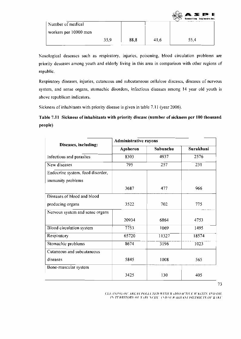
I workers per 10000 men I I I I I
C I I I I I I I I @ t n o l l e e r s . l D c
Nosological deseases such as respiratory, injuries, poisoning, blood circulation problems are
priority deseases among youth and elderly living in this area in comparison with other regions of
republic.
Number of medical
Respiratory diseases, injuries, cutaneous and subcutaneous cellulose diseases, diseases of nervous
system, and sense organs, stomachic disorders, infectious diseases among 14 year old youth is
above republican indicators.
I
Sickness of inhabitants with priority disease is given in table 7.1 1 (year 2006).
Table 7.11 Sickness of inhabitants with priority disease (number of sickness per 100 thousand
people)
Diseases, including:
Infectious and parasites
I Endocrine system, food disorder, 1 I I I
I I I
1 immunity problems I I I I I
Administrative rayons
Aps heron
8303
23 1 257 New diseases
Diseases of blood and blood
Sabunchu
4937
795
producing organs
Nervous system and sense organs
1 Stomachic problems 1 8674 1 3196 1 1023 1
Surakhani
2576
3687
Blood circulation system
Respiratory
I I
Cutaneous and subcutaneous i I
477
3522
diseases 5845 1008
Bone-muscular system
20934
7753
65720
( 1 1 {\I\<, 0 1 I K I 1 ~ 1 ' 0 1 1 1 I I 1 ) I I I I I I I { ~ I ) I O it I I C I . M 1 s 1 1 . 5 ~ \ I ) O I I 1 1 I 1 R h ' I I O R J 0 1 V I f!! \ ( . I l l 1 \I1 % i R ik l I {\I 111S77?1( I S 0 1 I{ I h l
702 775
6864
1069
1 1327
4753
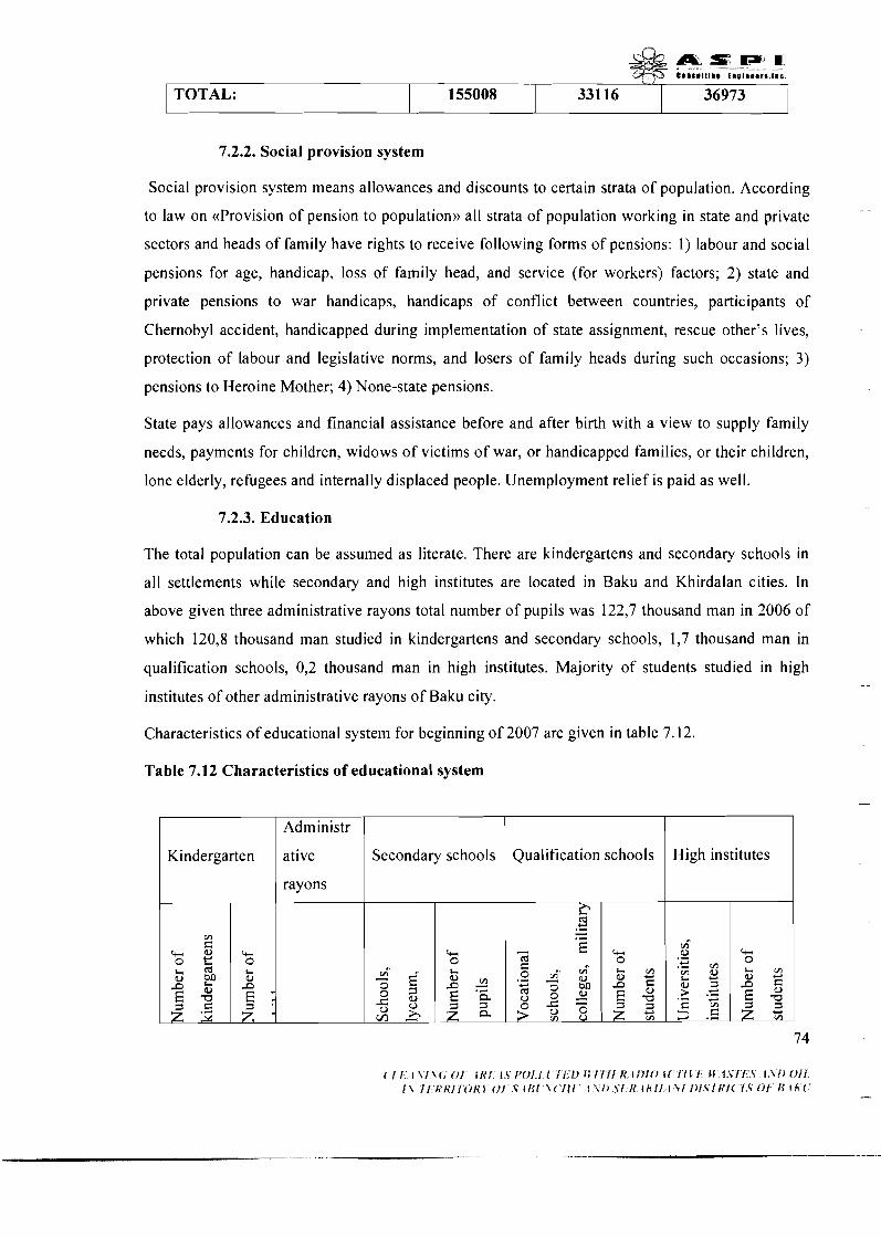
7.2.2. Social provision system
/
Social provision system means allowances and discounts to certain strata of population. According
to law on ((Provision of pension to population)) all strata of population working in state and private
sectors and heads of family have rights to receive following forms of pensions: I ) labour and social
pensions for age, handicap, loss of family head, and service (for workers) factors; 2) state and
private pensions to war handicaps, handicaps of conflict between countries, participants of
Chernobyl accident, handicapped during implementation of state assignment, rescue other's lives,
protection of labour and legislative norms, and losers of family heads during such occasions; 3)
pensions to Heroine Mother; 4) None-state pensions.
TOTAL:
State pays allowances and financial assistance before and after birth with a view to supply family
needs, payments for children, widows of victims of war, or handicapped families, or their children,
lone elderly, refugees and internally displaced people. Unemployment relief is paid as well.
7.2.3. Education
The total population can be assumed as literate. There are kindergartens and secondary schools in
all settlements while secondary and high institutes are located in Baku and Khirdalan cities. In
above given three administrative rayons total number of pupils was 122,7 thousand man in 2006 of
which 120,8 thousand man studied in kindergartens and secondary schools, 1,7 thousand man in
qualification schools, 0,2 thousand man in high institutes. Majority of students studied in high
institutes of other administrative rayons of Baku city.
155008
Characteristics of educational system for beginning of 2007 are given in table 7.12.
Table 7.12 Characteristics of educational system
33116 36973
I / rayons I I I I High institutes Kindergarten Secondary schools
Administr
ative Qualification schools
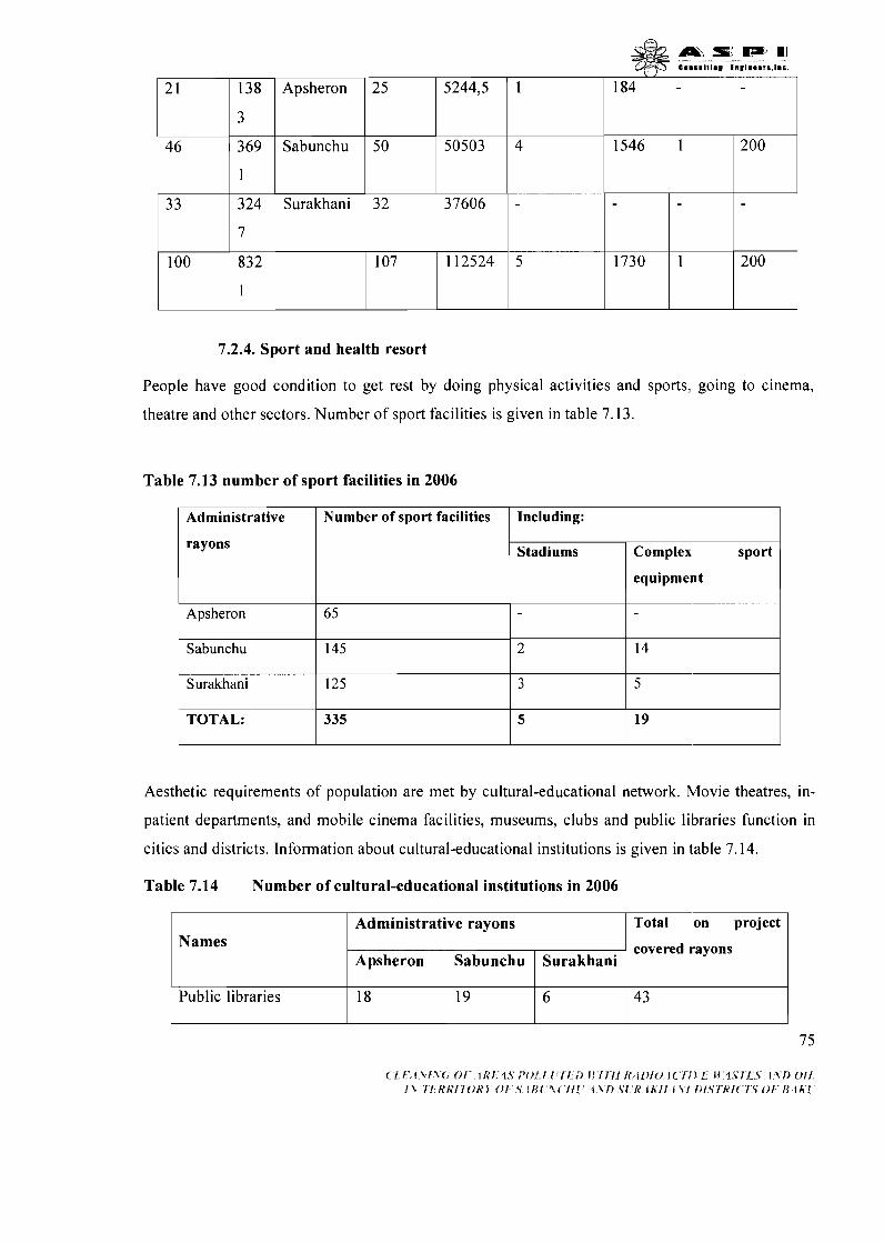
7.2.4. Sport and health resort
C 8 l t l l l l l l 1 1 9 1 1 B B 1 1 . 1 1 1
People have good condition to get rest by doing physical activities and sports, going to cinema,
theatre and other sectors. Number of sport facilities is given in table 7.13.
Table 7.13 number of sport facilities in 2006
1
4
-
5
Aesthetic requirements of population are met by cultural-educational network. Movie theatres, in-
25
50
32
107
Apsheron
Sabunchu
Surakhani
2 1
46
33
100
patient departments, and mobile cinema facilities, museums, clubs and public libraries function in
5244,5
50503
37606
112524
184
1546
1730
138
3
369
1
324
7
832
1
Administrative
rayons
Apsheron
Sabunchu
Surakhani
TOTAL:
cities and districts. Information about cultural-educational institutions is given in table 7.14.
Number of sport facilities
65
145
125
335
Including:
Table 7.14 Number of cultural-educational institutions in 2006
-
1
1
Stadiums
2
3
5
Names
200
200
Complex sport
equipment
14
5
19
1 Administrative rayons 1 Total on project I covered rayons
Apsheron
Public libraries
Sabunchu
18
Surakhani
19 6
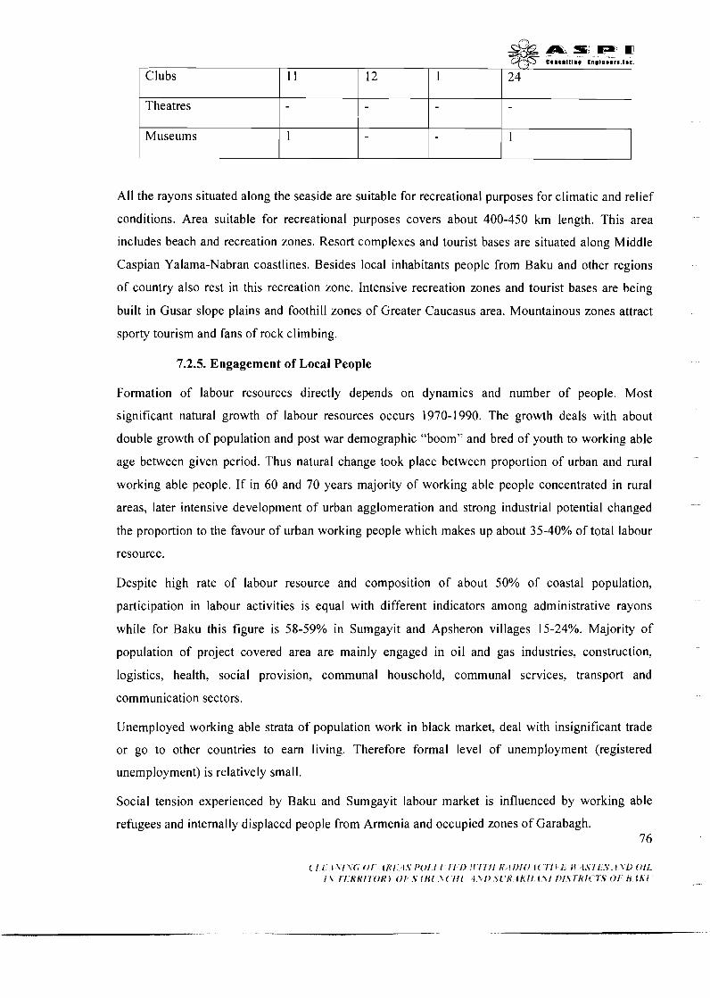
All the rayons situated along the seaside are suitable for recreational purposes for climatic and relief
conditions. Area suitable for recreational purposes covers about 400-450 km length. This area
includes beach and recreation zones. Resort complexes and tourist bases are situated along Middle
Caspian Yalama-Nabran coastlines. Besides local inhabitants people from Baku and other regions
of country also rest in this recreation zone. Intensive recreation zones and tourist bases are being
built in Gusar slope plains and foothill zones of Greater Caucasus area. Mountainous zones attract
sporty tourism and fans of rock climbing.
m s w m eonsmlt ln l tno lneers IIC
7.2.5. Engagement of Local People
Clubs
Theatres
Museums
Formation of labour resources directly depends on dynamics and number of people. Most
significant natural growth of labour resources occurs 1970-1990. The growth deals with about
double growth of population and post war demographic "boom" and bred of youth to working able
age between given period. 'Thus natural change took place between proportion of urban and rural
working able people. If in 60 and 70 years majority of working able people concentrated in rural
1 1
1
areas, later intensive development of urban agglomeration and strong industrial potential changed
the proportion to the favour of urban working people which makes up about 35-40% of total labour
resource.
12
Despite high rate of labour resource and composition of about 50% of coastal population,
participation in labour activities is equal with different indicators among administrative rayons
while for Baku this figure is 58-59% in Sumgayit and Apsheron villages 15-24%. Majority of
population of project covered area are mainly engaged in oil and gas industries, construction,
logistics, health, social provision, communal household, communal services, transport and
communication sectors.
1
Unemployed working able strata of population work in black market, deal with insignificant trade
or go to other countries to earn living. Therefore formal level of unemployment (registered
24
1
unemployment) is relatively small.
Social tension experienced by Baku and Sumgayit labour market is influenced by working able
refugees and internally displaced people from Armenia and occupied zones of Garabagh. 76
& a n : D F m e e n m n l t l n m I ~ O I D ~ ~ ~ S . I D C
7.2.6. Labour protection, production security and safety techniques
Legislative basis of labour protection and safety techniques consists of Constitution of the Republic
of Azerbaijan, Labour Code, standards accepted within body of relevant executive authorities,
international contracts favoured or joined by Azerbaijan Republic especially International
Convention of Labour Organization.
Every worker has rights to work under secure conditions in accordance with above standards.
Employer is responsible for workers to follow labour protection standards and norms, security of
buildings, structures, technological processes, and equipment, normal working and resting regimes,
training of workers on labour protection rules, provision of employees working in unsafe areas with
special protective uniforms, boots, individual protection facilities, free milk and curative food
products. According to legislation employees should get initial and periodical medical checkups on
account of employer as defined by law.
Control over organization of labour protection and adherence of employees to labour protection
rules is implemented by labour protection service of enterprise.
Employers of risky and unsafe enterprises must insure employees against accidents and work
related diseases on individual bases. All production accidents are registered and investigated by
State Labour Inspectors. Employees handicapped at work related accidents or diseases are
compensated at amounts and rules as defined by legislation on account of employer.
Control of adherence to labour protection rules is conducted by State Labour Inspection while
public control is carried out by trade unions organization. All standards and norms of labour
protection should be agreed with trade unions.
Law envisages some discounts and compensations for those working in unsafe production sector
which are increased tariffs and salaries, shorter work hours, additional holidays, and retire after
defined years of service. Employees working in low temperature, strong wind, and open air, rooms
without heating in cold months of year, and condition above 4 5 ' ~ are provided with vocations on
account of enterprise.
7.3 ECONOMY AND LAND USE
Baku Iodine Plant and the territory of landfill site to be constructed for disposal of radioactive
wastes located in Absheron Economical Region (AER). The territory of AER is 5,42 thousand
square kilometers, thereof 2,13 thousand square kilometers belongs to Baku city and 1,3 square 7 7
kilometers
d-b m ,p a ?@ 8B.8.ltlB. tRUl.88,S.l.C.
belong to Absheron district. The territory of Sabunchi and Surakhani districts are 24,O
and 10,O square kilometers correspondingly.
Economically and socially AER is most developed region of the country. 70% of gross domestic
product of the country falls to the share of the region. Economical potential of the region comprise
of fuel-energy complex, chemical and oil-chemical, engineering, metallurgy and other industries.
Oil and gas industries comprise of oil-extracting, oil refinery complex with 20,6 million tonlyear
productivity, natural gas refinery enterprise with 6,5 billion m31year productivity, 8 machine
building plants, deep-water foundations, stationary sea platforms, large marine comprising of more
than 300 ships for different purposes, 12 floating boring units and developed oil and gas pipelines.
Power production is represented by one HPP with 680 MW total power working on natural gas and
black oil, as well as four TPP. Approximately 15% of total power produced in country is produced
in these plants.
Metallurgiya kompleksi qara va alvan metallardan haz~r mamulatlar va prokat metal istehqal edan
miiassisalardan ibaratdir.
Machine-building sector consist of oil engineering plants, electronics and instrument-making plants,
radio and electric equipment plants and plants for production of home things mainly located in
Baku city.
Chemical and oil-chemical factories mainly located in Sumgayit. Main products produced in these
factories are active substances, hydrate of sodium, plastic masses, mineral fertilizers, glass raw
cotton without seeds and plastic glass, technical rubber products.
Light and food industries are large and well developed. Light and food industry enterprises are
mainly located in Absheron Economical Region and key industries in the country according to the
volume and range of goods. Light industry enterprises are producing cotton yarn, cotton and
woollen cloths, socks, towelling, foot-wears and knitted garments.
Food industry enterprises are mainly specialized on bread and macaroni, meat and milk products,
margarine, vegetable oils, confectionery, alcoholic and non-alcoholic drinks, as well as fish
products.
Production of construction materials is based mainly on local raw materials and meets the needs of
country for cement, asbestos-cement, ceramic and cast-iron sanitary engineering equipment,
window glass, reinforced concrete blocks, construction stone and facing materials, wooden, plastic
and aliminium products. 7 8
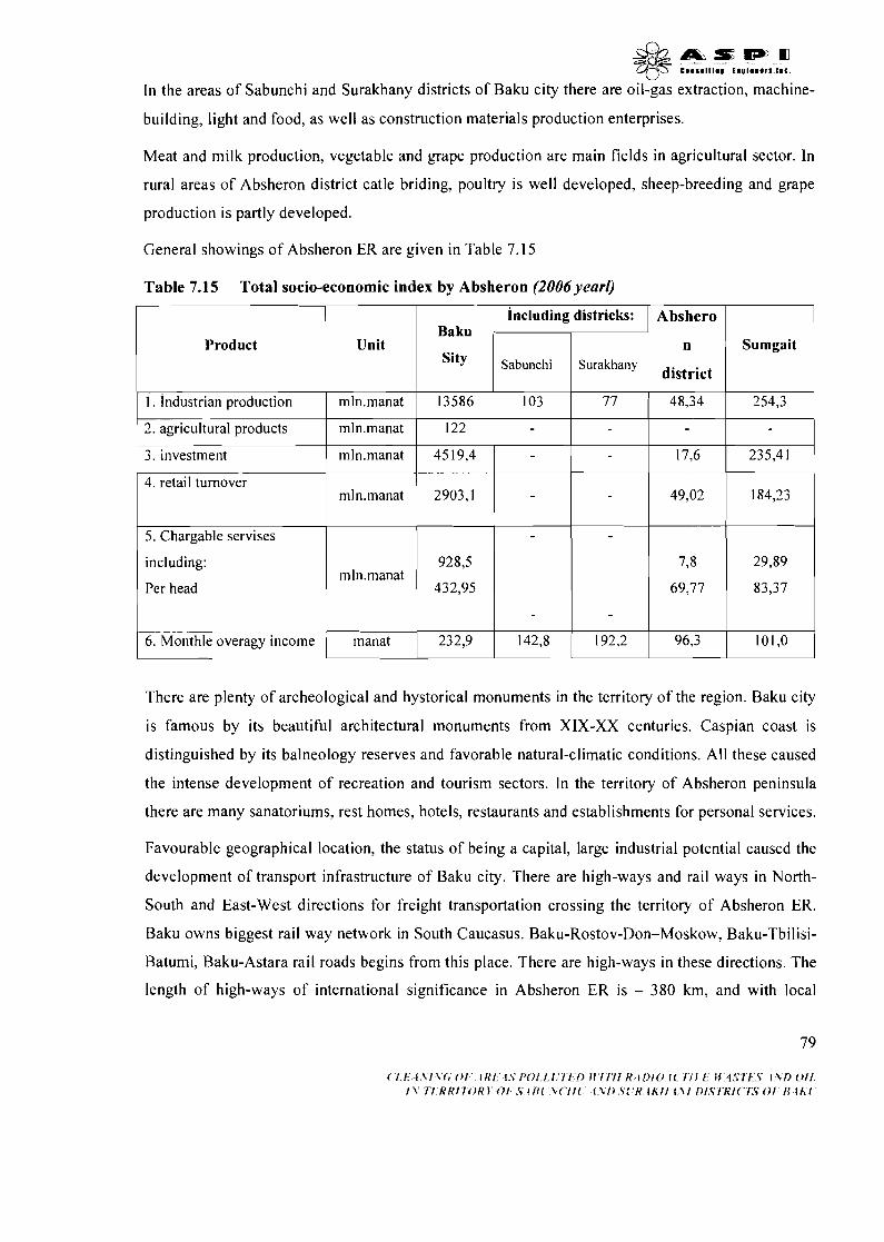
u
In the areas of Sabunchi and Surakhany districts of Baku city there are oil-gas extraction, machine-
building, light and food, as well as construction materials production enterprises.
Meat and milk production, vegetable and grape production are main fields in agricultural sector. In
rural areas of Absheron district catle briding, poultry is well developed, sheep-breeding and grape
production is partly developed.
General showings of Absheron ER are given in Table 7.15
1 2. agricultural products I 1 I I I
mIn.manat 122 -I
Table 7.15 Total socio-economic index by Absheron (2006 yearl)
1 5. Chargable servises I I 1 - 1 - 1 I I
Product
3. investment
4. retail turnover
including:
Per head
Baku
Sity Unit
mln.manat
mln.manat
There are plenty of archeological and hystorical monuments in the territory of the region. Baku city
is famous by its beautiful architectural monuments from XIX-XX centuries. Caspian coast is
distinguished by its balneology reserves and favorable natural-climatic conditions. All these caused
the intense development of recreation and tourism sectors. In the territory of Absheron peninsula
there are many sanatoriums, rest homes, hoteIs, restaurants and establishments for personal services.
6. Monthle overagy income
Favourable geographical location, the status of being a capital, large industrial potential caused the
development of transport infrastructure of Baku city. There are high-ways and rail ways in North-
South and East-West directions for freight transportation crossing the territory of Absheron ER.
Baku owns biggest rail way network in South Caucasus. Baku-Rostov-Don-Moskow, Baku-Tbilisi-
Batumi, Baku-Astara rail roads begins from this place. There are high-ways in these directions. The
length of high-ways of international significance in Absheron ER is - 380 km, and with local
including districks:
4519,4
2903,l
Abshero
n
district
.
Sabunchi
manat
Sumgait Surakhany
17,6 -
235,41
232,9
49,02
142,8 192,2 96,3 101,O

significance
& & a e ~ J m +p C l l l l l l l l . I " 9 1 . O o r l . i l l .
is 3000 km. There are local (Baku-Ganja and Nakhchivan) and international flights
from city airport.
Baku seaport is a leading port among Caspian ports and consist of five terminals. Two out of them
are meant for dry goods and the rest is meant for oil, ferry and passenger transportation. Water
transportation is implemented with Astrakhan, Mahachgala, Aktau, Turkmenbashy, Betash,
Noushehr and Bender Abbas ports.
Absheron ER owns biggest manpower reserves in the country. In comparison with other regions
realization of manpower reserves is much higher here. Able-bodied citizens are mainly engaged in
fuel-energy sector, in different industries, and some engaged in education, science and agriculture.
7.4 COMMUNAL SERVICES
7.4.1. Energy supply
Energy supply of Baku and Apsheron peninsula is implemented on the bases of electricity and
heating energy, including gas supply.
Region is supplied 100% with electricity including remote locations. Electricity network includes
300-500 kV intersystem high voltage lines, 220-110 kV supply networks, and 35-0,4 kV
distribution nets. High voltage (1 10-500 kV) networks ensure transportation and distribution of
energy produced between neighbouring energy systems. Annual energy consumption varies
between 8-10 billion square hours. Losses in the feeding networks are 4,7-5,0%, while in the
distribution network 4,O-4,3%.
Baku, Sumgayit and Khirdalan towns are supplied with thermal energy. Thermal supply industry
and heating HES, rayon and industrial boilers, small boilers, and heating generators installed in
apartments all supply heating. Annual heating production of HES is 2,O-2,5 Qkal. All thermal
energy production facilities work at their 10-15% capacity. About 40% of aggregates of HES and
boiling houses are outdated, while rest are uneconomical and inefficient. Majority of hydro and
thermal isolations are unsafe causing losses. Public buildings, health objects, service areas, multi-
flat buildings are usually supplied with thermal energy. Heating of private households, small
buildings, and rural settlements is implemented by gas and firewood stove.
Apsheron peninsula is entirely supplied with natural gas.
According to recent data natural gas consumption in industry and housing-communal sector was
4,O-4,5 billion m3. Losses during gas delivery comprise 4-5% of total supply. 80
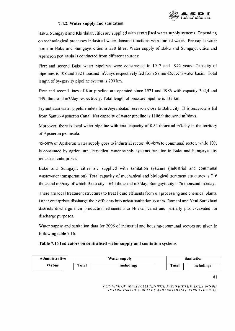
7.4.2. Water supply and sanitation
Baku, Sumgayit and Khirdalan cities are supplied with centralised water supply systems. Depending
on technological processes industrial water demand functions with limited water. Per capita water
norm in Baku and Sumgayit cities is 330 litres. Water supply of Baku and Sumgayit cities and
Apsheron peninsula is conducted from different sources:
First and second Baku water pipelines were constructed in 1917 and 1942 years. Capacity of
pipelines is 108 and 232 thousand m3/days respectively fed from Samur-Devechi water basin. Total
length of by-gravity pipeline system is 200 km.
First and second lines of Kur pipeline are operated since 1971 and 1986 with capacity 302,4 and
449, thousand m3Iday respectively. Total length of pressure pipeline is 135 km.
Jeyranbatan water pipeline inlets from Jeyranbatan reservoir close to Baku city. This reservoir is fed
from Samur-Apsheron Canal. Net capacity of water pipeline is 1106,9 thousand m3/days.
Moreover, there is local water pipeline with total capacity of 0,84 thousand m3Iday in the territory
of Apsheron peninsula.
4 5 5 0 % of Apsheron water supply goes to industrial sector, 40-45% to communal sector, while 10%
is consumed by agriculture. Periodical water supply systems function in Baku and Sumgayit city
industrial enterprises.
Baku and Sumgayit cities are supplied with sanitation systems (industrial and communal
wastewater transportation). Total capacity of mechanical and biological treatment structures is 716
thousand m3Iday of which Baku city - 640 thousand m3/day, Sumgayit city - 76 thousand m3lday.
There are local treatment structures to treat liquid effluents from oil processing and chemical plants.
Other enterprises discharge their effluents into urban sanitation system. Ramani and Yeni Surakhani
districts discharge their production effluents into Hovsan canal and partially pits excavated for
discharge purposes.
Water supply and sanitation data for 2006 of industrial and housing-communal sectors are given in
following table 7.16.
Table 7.16 Indicators on centralised water supply and sanitation systems
Administrative
rayons
Water supply
Total
Sanitation
including: Total including:
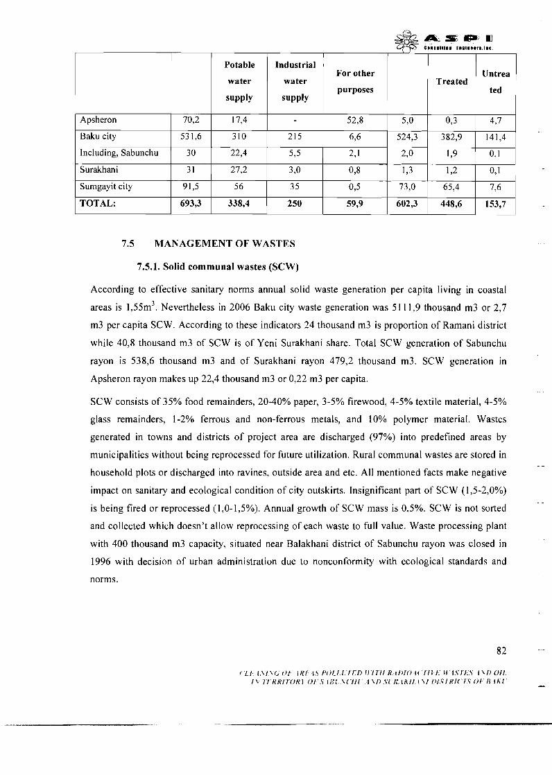
Potable
water
supply
Industrial
water
supply
For other
purposes
-
Treated Untrea
ted
I I I I 1 I I
1 I I I I I I
Including, Sabunchu 1 30 1 22,4 5 s 1,9 ) 0,I ~ Apsheron
I I I
Baku city
7.5 MANAGEMENT OF WASTES
70,2
Surakhani
7.5.1. Solid communal wastes (SCW)
53 1,6
Sumgayit city
TOTAL:
According to effective sanitary norms annual solid waste generation per capita living in coastal
17,4
areas is 1,55m3. Nevertheless in 2006 Baku city waste generation was 51 11,9 thousand m3 or 2,7
52,8 1 5,o 1 0,3 4,7
3 10
91,5
693,3
m3 per capita SCW. According to these indicators 24 thousand m3 is proportion of Ramani district
while 40,8 thousand m3 of SCW is of Yeni Surakhani share. Total SCW generation of Sabunchu
rayon is 538,6 thousand m3 and of Surakhani rayon 479,2 thousand m3. SCW generation in
215
5 6
338,4
Apsheron rayon makes up 22,4 thousand m3 or 0,22 m3 per capita.
6,6 1 524,3 1 382,9 1 141,4
SCW consists of 35% food remainders, 20-40% paper, 3-5% firewood, 4-5% textile material, 4-5%
3 5
250
glass remainders, 1-2% ferrous and non-ferrous metals, and 10% polymer material. Wastes
generated in towns and districts of project area are discharged (97%) into predefined areas by
0 3
59,9
municipalities without being reprocessed for future utilization. Rural communal wastes are stored in --
household plots or discharged into ravines, outside area and etc. All mentioned facts make negative
impact on sanitary and ecological condition of city outskirts. Insignificant part of SCW (1,5-2,0%)
is being fired or reprocessed (1,O-1,5%). Annual growth of SCW mass is 0,5%. SCW is not sorted
73,O
602,3
and collected which doesn't allow reprocessing of each waste to full value. Waste processing plant
with 400 thousand m3 capacity, situated near Balakhani district of Sabunchu rayon was closed in
65,4
448,6
1996 with decision of urban administration due to nonconformity with ecological standards and
7,6
153,7
norms.
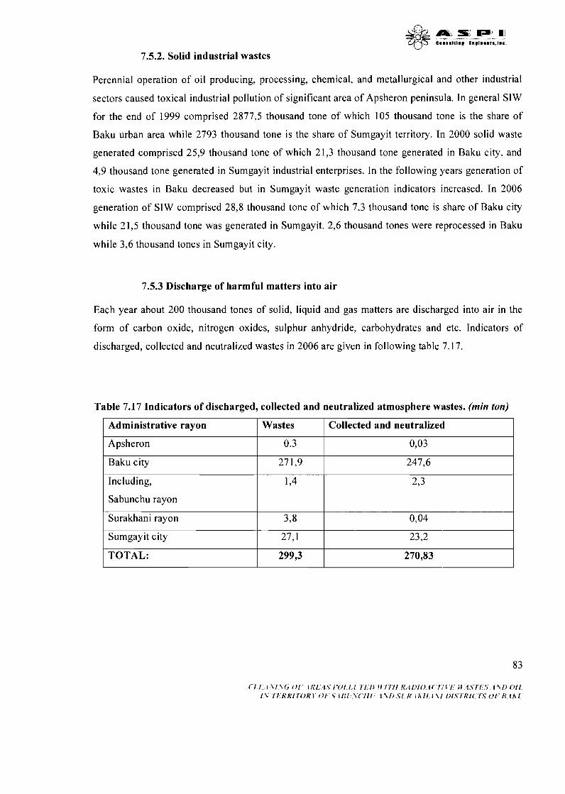
7.5.2. Solid industrial wastes
Perennial operation of oil producing, processing, chemical, and metallurgical and other industrial
sectors caused toxical industrial pollution of significant area of Apsheron peninsula. In general SIW
for the end of 1999 comprised 2877,5 thousand tone of which 105 thousand tone is the share of
Baku urban area while 2793 thousand tone is the share of Sumgayit territory. In 2000 solid waste
generated comprised 25,9 thousand tone of which 21,3 thousand tone generated in Baku city, and
4,9 thousand tone generated in Sumgayit industrial enterprises. In the following years generation of
toxic wastes in Baku decreased but in Sumgayit waste generation indicators increased. In 2006
generation of SIW comprised 28,8 thousand tone of which 7,3 thousand tone is share of Baku city
while 21,5 thousand tone was generated in Sumgayit. 2,6 thousand tones were reprocessed in Baku
while 3,6 thousand tones in Sumgayit city.
7.5.3 Discharge of harmful matters into air
Each year about 200 thousand tones of solid, liquid and gas matters are discharged into air in the
form of carbon oxide, nitrogen oxides, sulphur anhydride, carbohydrates and etc. Indicators of
discharged, collected and neutralized wastes in 2006 are given in following table 7.17.
Table 7.17 Indicators of discharged, collected and neutralized atmosphere wastes. (min ton)
Administrative rayon
Apsheron
Baku city
Including,
Sabunchu rayon
Surakhani rayon
Sumgayit city
TOTAL:
Wastes
0.3
27 1,9
1,4
3,8
27,l
299,3
Collected and neutralized
0,03
247,6
2,3
0,04
23,2
270,83
8. ECOLOGICAL RISKS
8.1 PRODUCTION FIELDS OF BAKU IODINE PLANT AND CONDITION OF
ENVIRONMENTAL POLLUTION IN ADJACENT AREAS
Primary evaluation of environmental pollution of Baku Iodine Plant production fields is reflected in
schematic maps explaining existing situation. (Figure 8. land 8.2).
8.1.1. Radioactive wastes
Following radiological wastes were determined to evaluate real radionuclide pollution of Ramani
and Surakhani production fields:
- according to harm of radiation I1 and 111 category of carbon; slightly burned carbon with special
net activity - 55000 Bklkg has been defined.
- according to harm of radiation I and I1 category of carbon and sand mixed with carbon;
- according to harm of radiation I and I1 category of carbon mixed with brick;
- according to harm of radiation I and I1 category of asbestos pipes covered with deposits;
- according to harm of radiation I and I1 category of various mixtures of discharges. -
Summary of evaluation of both production fields, carred out by "Izotop" Spesial Center, is given
below.
8.1.1.1 Ramani production field
Following evaluation measures were taken in the production field:
gamma-radiometric mapping of 1 :500 scale of field;
water sampling to discover radionuclide;
a solid wastes sampling to discover presence of radionuclide;
a search for presence of radon gas in atmosphere. -.
Sampling and measuring points is reflected in schematic-map of radiometric observations of
Ramani production field (Figure 8.3)
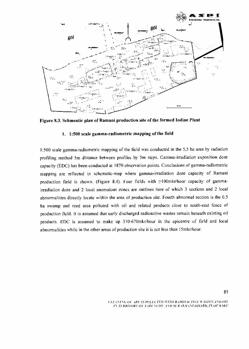
Figure 8.3. Schmeatic plan of Ramani production site of the formed Iodine Plant
1. 1:500 scale gamma-radiometric mapping of the field
1:500 scale gamma-radiometric mapping of the field was conducted in the 5,5 ha area by radiation
profiling method 5m distance between profiles by 5m steps. Gamma-irradiation exposition dose
capacity (EDC) has been conducted at 1870 observation points. Conclusions of gamma-radiometric
mapping are reflected in schematic-map where gamma-irradiation doze capacity of Ramani
production field is shown. (Figure 8.4). Four fields with ~100rnkrlhour capacity of gamma-
irradiation doze and 2 local anomalous zones are outlines here of which 3 sections and 2 local
abnormalities directly locate within the area of production site. Fourth abnormal section is the 0.5
ha swamp and reed area polluted with oil and related products close to south-east fence of
production field. It is assumed that early discharged radioactive wastes remain beneath existing oil
products. EDC is assumed to make up 310-670mkrlhour in the epicentre of field and local
abnormalities while in the other areas of production site it is not less than 15mkrlhour.
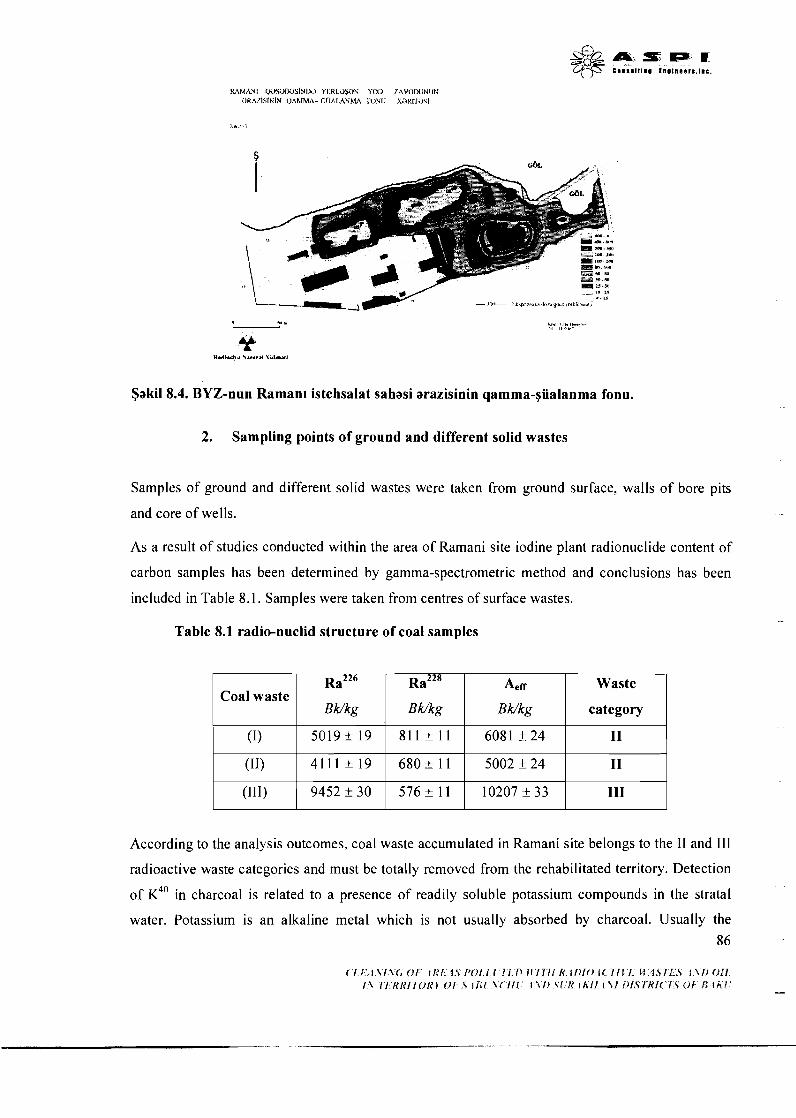
Saki1 8.4. BYZ-nun Raman~ istehsalat sahasi arazisinin qamma-yiialanma fonu.
2. Sampling points of ground and different solid wastes
Samples of ground and different solid wastes were taken from ground surface, walls of bore pits
and core of wells.
As a result of studies conducted within the area of Ramani site iodine plant radionuclide content of
carbon samples has been determined by gamma-spectrometric method and conclusions has been
included in Table 8.1. Samples were taken from centres of surface wastes.
Table 8.1 radio-nuclid structure of coal samples
According to the analysis outcomes, coal waste accumulated in Ramani site belongs to the I1 and 111
Coal waste
(1)
(11)
(111)
radioactive waste categories and must be totally removed from the rehabilitated territory. Detection
of K~~ in charcoal is related to a presence of readily soluble potassium compounds in the stratal
~a~~~
BWkg
5 0 1 9 f 1 9
4111 k 19
9452 f 30
water. Potassium is an alkaline metal which is not usually absorbed by charcoal. Usually the 86
~a~~~
B Wkg
8 1 1 f 11
6 8 0 f 11
576 f 11
Aef~
B Wkg
608 1 + 24
5002 f 24
10207 +_ 33
Waste
category
I1
I1
I11
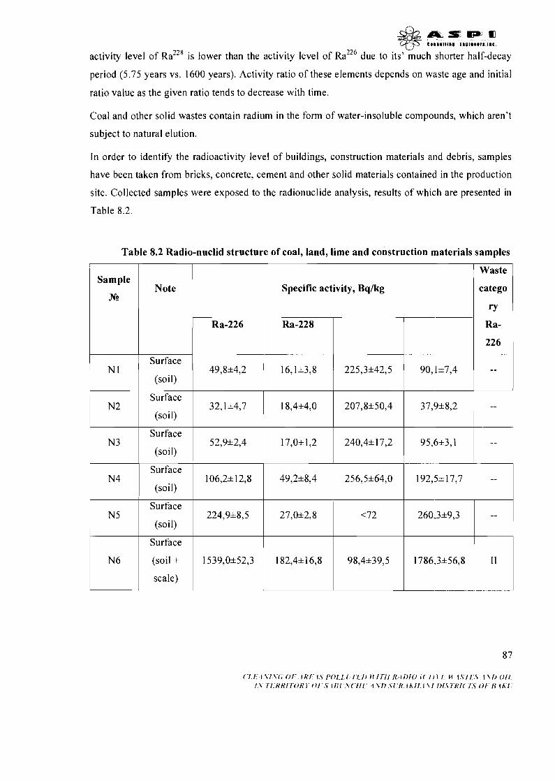
& & a e w m C ~ I U I I I ~ V i n u l m e e r s , l m c .
activity level of RaZ" is lower than the activity level of ~a~~~ due to its' much shorter half-decay
period (5.75 years vs. 1600 years). Activity ratio of these elements depends on waste age and initial
ratio value as the given ratio tends to decrease with time.
Coal and other solid wastes contain radium in the form of water-insoluble compounds, which aren't
subject to natural elution.
In order to identify the radioactivity level of buildings, construction materials and debris, samples
have been taken from bricks, concrete, cement and other solid materials contained in the production
site. Collected samples were exposed to the radionuclide analysis, results of which are presented in
Table 8.2.
Table 8.2 Radio-nuclid structure of coal, land, lime and construction materials samples
Sample ~ 3.2 Note Specific activity, Bqlkg
Waste
catego
1 Ra-226 1 Ra-228 1 I 1 Ra-
Surface 49,8*4,2 16,1&3,8 225,3*42,5 90,1&7,4
(so i I)
Surface 32,1&4,7 18,4*4,0 207,8*50,4 37,9*8,2
(so i I)
Surface
(soi 1)
(soil + 1 1539,0*52,3 1 182,4*16,8 1 98,4*39,5 1 1786.3*56,8 1 II
Surface
(soi I )
Surface
(so i I)
Surface
scale) I
52,9*2,4
49,2*8,4 106,2*12,8
224,9&8,5
17,0* 1,2
256,5*64,0 192,5& 17,7
27,0*2,8
240,4*17,2 95,6*3,1 7 <72 260.3*9,3 --
\ 3
Waste Sample
Nc Note 1 Specific activity, Bqlkg catego
dcoal) 1
'7'
Ra- Ra-226
Surface
(soil + combuste
Surface
Ra-228
(soil +
52400rt5299
scale)
Surface
(soil +
1837rt258
scale)
Surface
(soil + scale)
Surface
(soil + coal)
Surface
(soil)
91 5,0*608,0
1 N l l
Surface
(soil)
Surface
(soil + coal)
54884,3*53 10
Surface
(soil +
coal)
226
111
Cement
Concrete
\ ,
Sample Note Specific activity, Bqlkg catego
N2
Concrete 1 47,3+1,7 1 35,1*1,9 7 5 3 , 6 * 3 0 , 1 1 157,3*3,9 I -- Asbestos
1488,0*161 1 15,9*20,2 50,2*40,4 1644,1* 1 63,2 pipe
Surface
(soil + little coal)
Surface
(soil)
298,3*6,6
Surface
(scale)
208,4*7,1
309,9*35,8
Surface
(scale)
42,1*3,1
351,2*12,5
Surface
(scale)
39,2*4, l
256,5*34,6
Fuel oil + coal
208,6*27,7
1073 1*158
Surface
(soil)
5565,2*28,5 (coa I)
2 16,5*3 1,2
284,6*25,2
Surface
(coal)
Surface 9456,8*66,3 (coal)
37 1,2*8,1
9564,3*3 1,2
I
278,2*9,3 --
Surface
(coal) 3256,5*52,1
@ & a s ~ o LpJ5 C ~ I * . I l I I . i"ll...rs.l.L .
According to the testing results (tests # N16, N17 and N18), buildings and construction
materials located on sites may not be regarded as radioactive waste, i.e. their radionuclide content is
typical for such kinds of material. Although some of the construction materials are in direct contact
with radioactive waste, radium bearing compounds are water-insoluble and do not affect the
construction materials content.
Soil sample taken from the sampling point N7 (see Fig. 8.3) has extremely high level of specific
activity. The situation requires area's decontamination through the total removal of topsoil at a - -
diameter of 4 m and depth of 1.5 m. Topsoil excavation at a diameter of 4 and depth of 1 m is
required to decontaminate areas located close to the mentioned site, i.e. the sampling points N6, N8,
N9 and N 10.
. . Scale accumulated on walls of the asbestos and polyethylene pipes refers to I1 radiation hazard
category and needs to be treated accordingly. Scraping of scale from the walls isn't desirable in
terms of the security considerations.
As seen from the analysis of solid samples collected from the site's eastern part (N 17, N28, N29
and N30), the area is also exposed to considerable radioactive contamination, which requires total
removal of topsoil up to a 1 m depth. Pools situated in this area need to be cleaned of accumulated
radioactive waste.
Other radiologically contaminated areas need to be decontaminated through the removal of
topsoil up to the depth of 50 cm.
In order to assess the underground penetration of the radioactive waste, 16 bore pits have been
drilled 5- 2,5 metres deep and 84 samples collected to go through the radionuclide analysis on the
Ramana Site. Analysis outcomes are presented in the Table 8.3.
Table 8.3 Radionuclide structure of samples from wells
Was
Specific activity level
Bq/kg
te
cate
gory
Ra-
226
Ra-226 Ra-228
Was
Specific activity level
Bq/kg cate
gory
Ra-
226
0-20
charcoal
Bore pit
20-40
mixed
40-80
mixed
80- 120
soil
120-150
soi 1
0-20
charcoal +
soi 1
20-40
mixed
40-80
mixed
80- 1 20
soil
I Bore pit
N!? 2
(Ramani)
120-1 50
soi 1
0-20
charcoal
20-40
soil
40-80
soil
(Ramani)

80- 100
soil
Sample
N!?
100-130
soil
soil
Depth, cm
1 charcoal
Bore pit 40-80
N?! 4 I mixed
(Ramani)
mixed
mixed
Bore pit
Nc 5 mixed
(Ramani) 20-40 mixed
soil
soil
I soil
Specific activity level
Was
te
gory
Ra-226 Ra-228 Ra-
226 1

Sample
No Depth, cm
Specific activity level
Bq/kg
te
cate
~ O r y
Ra-
226
0-20 coal + 1 1 1441,6141.5 27 ,6n ,3 <56 1 1481,8*41,9 1 1 soil + scale
130-170
soil
Bore pit
Nc 6
(Ramani)
Ra-226
2 1,3*5,2
I
20-40
soil + scale
charcoal
Ra-228
-----
3,9* 1,7
238,9*25,7
40-80
grey soil
80- 1 20
grey soil
120-150
grey soil
Bore pit
N? 7
(Ramani)
mixed
120-150
202,2*42,4
6,2*2,9
3 1,4*3,3
49,9*4,7
49,3*1,5
soi 1 +
43,6*6,7
Bore pit
N? 8
13 1,5*38,0
12,8*3,4
10,3* 1,6
3,1*0,7
mixed
258,2*26,2
(Ramani)
<47
<45
47,2* 10,3
20-40
mixed
48,1*5,5
63,4*5,2
57,4*2,0
--
--
--
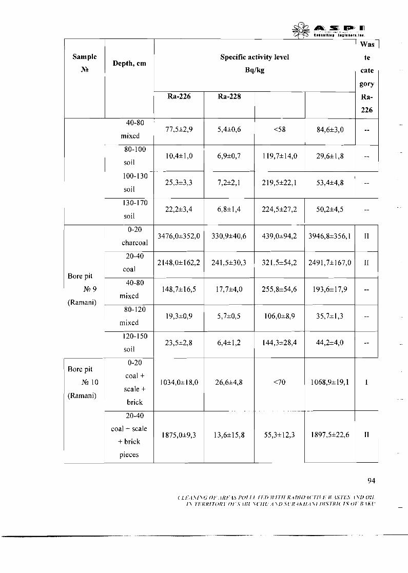
a , = m m C o l s 1 l l l 1 # l n o l n l l r a l ~ t
Was
Specific activity level
Bq/kg
Sample
No I
te
cate Depth, cm
gory
Ra-
226
-- mixed
soil
soil
soil I" charcoal
mixed (Ramani)
mixed
soil
0-20
coal + scale + brick
20-40
coal + scale
+ brick
pieces
Bore pit
N!? 10
(Ramani)
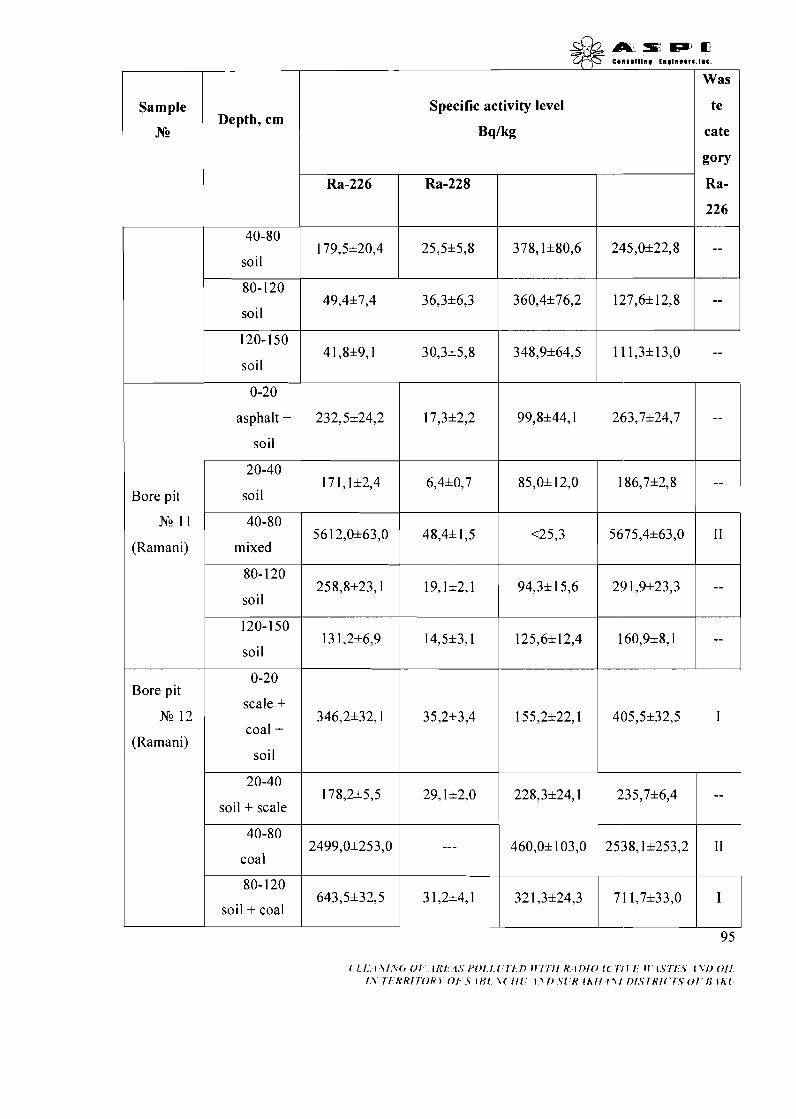
soil
80- 120
soil
120-150
soil
0-20
asphalt + soil
Bore pit 1 soil
(Ramani) mixed
soil
1 soil
(Ramani)
Bore pit
coal + soil
0-20
scale +
1 soil + scale
N!? 12
Specific activity level
Bq/kg
te
cate
gory
( l I . . 1 1 I ~ ( r 0 1 IKI 1.5/'0!1 1 1 1 1 ) I I I I I l K I I ) IO1 ( 17 I I . M I S I I 5 1\1)011 I \ I I R R I l O R 5 0 1 Iff1 \ ( I l l ~ \ l ~ ~ l K l h / l l ~ / f ~ f ~ / R l ~ ~ f . V O l / $ l A i
Ra-226
179,5&20,4
Ra-228
25,5+5,8 378,1&80,6 245,0+22,8
Ra-
226
--
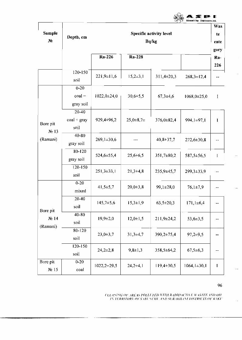
A L S I P J B C l n l l l l l m l I n o I n n ~ r ~ . l ~ c
Was
Sample r r Specific activity level
B q / k
te
cate Depth, cm 1
soil
coal + gray soil
coal + gray
soil Bore pit
NG 13
(Ramani) 40-80
gray soil
gray soil
120-150
soil
mixed
soil Bore pit
NG 14 soil
(Ramani)
soil
soil
Bore pit
coal
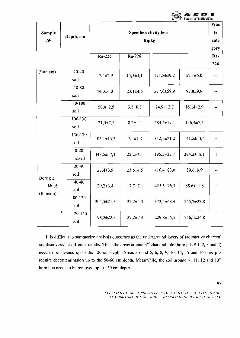
I Was I Sample
N2
(Ramani)
Depth, cm
soil
soil
Specific activity level
Bq/kg
te
cate
gory
80- 100 150,4*2,5 3,5*0,8 74,9* 12,7 16 1,4*2,9
soil
100-130 121,5*7,1 8,2* 1,4 284,5*17,1 156,4*7,5
soil
130-170 105,1*13,2 7,5*1,2 312,5*21,2 141,5*13,4
soil
0-20
mixed
It is difficult to summarize analysis outcomes as the underground layers of radioactive charcoal
are discovered at different depths. Thus, the areas around 3rd charcoal pile (bore pits # 1, 2, 3 and 4)
need to be cleaned up to the 120 cm depth. Areas around 5, 6, 8, 9, 10, 14, 15 and 16 bore pits
require decontamination up to the 50-60 cm depth. Meanwhile, the soil around 7, 11, 12 and 13Ih
bore pits needs to be removed up to 150 cm depth.
20-40
soil
( 1 1 1 1 1 \ ( , 0 1 1N1 1.> I ' O I l ( I l l ) I I I I I I N ~ I I ) I O l ( I l l ! Il 4 Y I I . 5 I ~ I I O l I I \ l I R R l 1 0 R J 0 1 V l l J [ \ ( I l l 4\1) S[ N I h f l l \ l l ) I S l R I ( I S 0 1 1 1 1 h [
348,5*17,1
Bore pit 40-80
Ng 16
(Ramani) 80- 120
204,5*21,3 22,2*4,3 372,5*68,4 265,2*22,8 -- soil
23,4*3,9
22,2*4,1
23,5*4,5
195,5*27,7
4 16,4*83,0
394,2*18,1 1
89,6*9,9 --
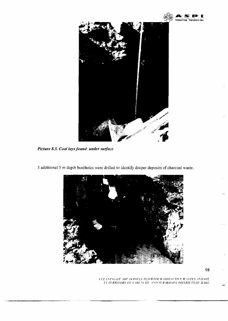
Picture 8.5. Coal lays found under surface
5 additional 5 m depth boreholes were drilled to identify deeper deposits of charcoal waste.
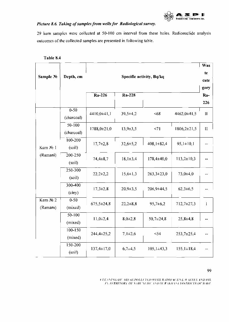
* Picture 8.6. Taking of samples from wells for Radiological survey.
w
29 kern samples were collected at 50-100 cm internal from these holes. Radionuclide analysis
outcomes of the collected samples are presented in following table.
Table 8.4
Sample Nc Depth, cm
0-50
(charcoal)
Specific activity, Bqlkq
Was
te
cate
Ra-226 Ra-228 Ra-
226
44 1 0,0+4 1,l
Kern Nr! 1
(Ramani)
39,5+4,2
100-200
(soil)
200-250
250-300
50- 100
(mixed)
100- 1 50
(mixed)
150-200
(soil)
22,2+2,2
17,3+2,8
675,5+24,8 Kern Nr! 2
<6 8
(soil) ~ 17,7+2,8
74,4+8,7
(soil)
300-400
(C ley
0-50
(Raman~)
1 1,0&2,4
244,4&25,2
137,4& 17,O
15,6+ 1,3
20,9+3,5
22,2+8,8 (mixed) ~
4462,0+4 1,5
32,6+5,2
18,1*3,4
8,0*2,8
7,1&2,6
6,7*4,5
I1
263,3+23,0
206,9+44,5
95,7+6,2
408,1+82,4
178,4+40,0
7 12,7+27,3
50,7&24,8
<54
105,1&43,3
95,1+10,1
1 13,2+10,3
25,8&4,8
--
--
--
253,7&25,4 --
155,1&18,4 --
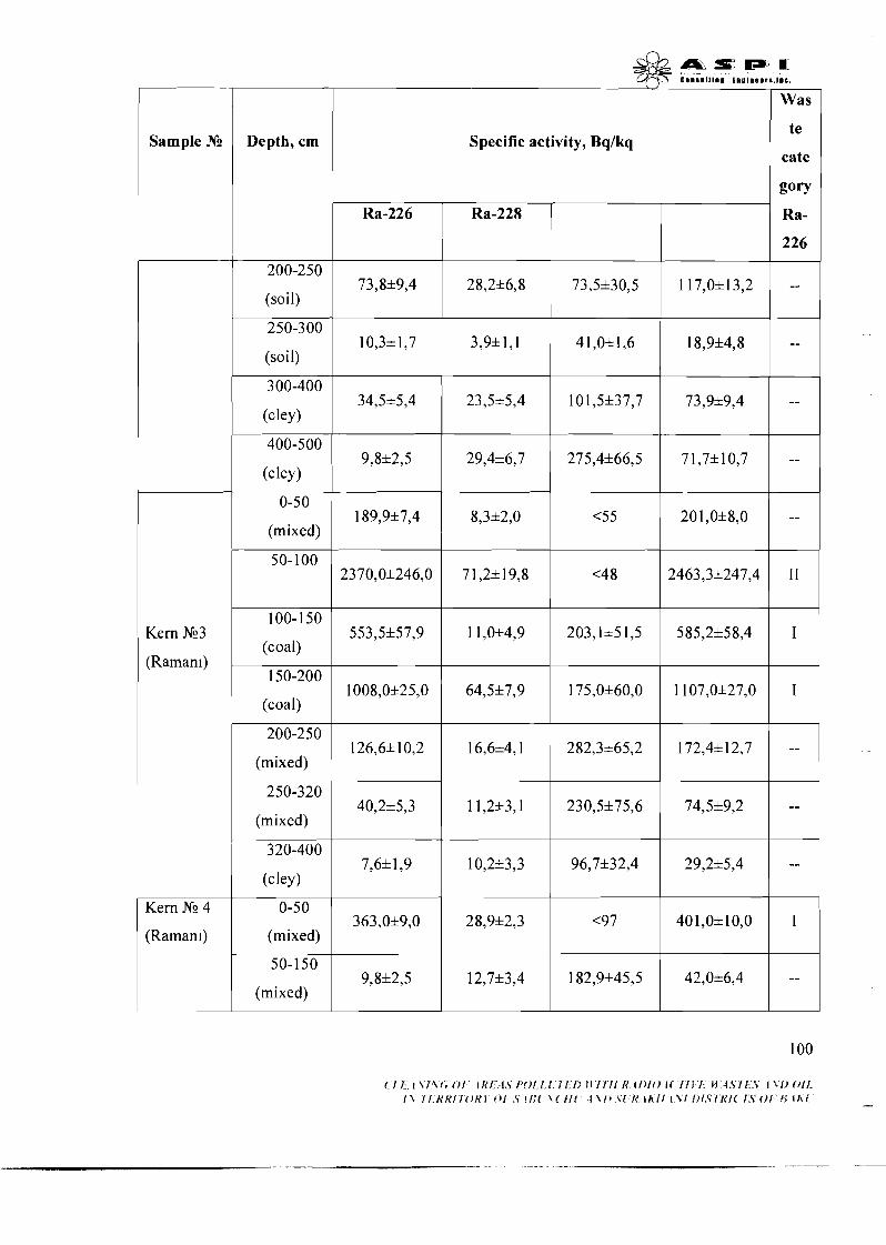
m s IPJ a1 e5 C....I~l.. En.... r. ,...
Was
Sample No I
Specific activity, Bqlkq te 1 cate
Depth, cm
Ra- 1 226
200-250
(soil)
250-300
(so i 1)
300-400
(cley)
400-500
(cley)
0-50
(mixed)
50-100
100-1 50
(coal)
150-200
(coal)
200-250
(mixed)
Kern N23
(Raman~)
250-320
(mixed)
320-400
(cley)
Kern Nc 4
(Raman~)
0-50
(mixed)
50-1 50
(mixed)

Specific activity, Bqlkq Sample JTg
Ra-
226
Depth, cm
1
0-50 54,216,5 1 1.9*2,5 117,1*12,5 79,7*7,4
(soil)
Kern analysis confirmed the presence of underground charcoal deposits up to the depth of 2 m.
Thus, 2 m thickness of soil cover around kern sampling point #3 should be removed.
3. Collection of groundwater samples for radionuclide analysis
Samples were collected from bottom of the developed bore pits and from the surface of artificial
reservoir. Samples were sent to the laboratory for identification of radium isotopes. Analysis
outcomes are given in following table.
Kern N? 5
Table 8.5 Water-soluble species of radium
50-1 50
(so i I)
I S a m ~ l e NC Activity level, mBWl
12,7*2,6 1 13,9*3,3 46,716,5 185,8149.0 --
& & + S E W 9 emn11111na ino lmeers . tnc .
Water 1
Water 2 1 I
20,6* 1,2
19,4* 1,3
Water 3
Water 5
14,6* 1,4
13,9*1,5
I I
52,0*2,0
176,0*6,8
Water 6
Water 7
Specific activity level of radium isotopes contained in water is very low. Surfacing of stratal waters
29,4*3,6
101,3&5,2
I I
creates favorable condition for forming of water-insoluble radium compounds. While stratal waters
184,0*6,0
1 17,1&6,2
Water 8
contain I1 group elements including radium, reduction of pressure and temperature due to water's
1 10,016,O
82,1&5,1
exposure to daylight may lead to excessive dissolution of the contained mixed sulfates and
82,0&4,0
carbonates. This factor, in its' turn, may lead to the elements' accumulation in the form of sulfate
52,0&4,0 I
and carbonate deposits. Elements may deposit on the inner walls of pipes, pumps and separators, or
in the bottom sediments of the artificial lake, etc. Deposition occurs when crystals are created due to
a favorable medium created by turbulent flow, centripetal powers and crystallization process. Clay
and sands extracted from the productive layer may also serve as favorable factors. Once stratal
waters are mixed with brine to increase oil production output, deposition process intensifies as a
result of increased sulfate thickness. Deposition may also take place as a result of brine penetration
into the productive layer, or due to the mixing of stratal water produced from different wells, inside
of the pipelines and equipment. Therefore, quite little volumes of dissolved radium isotopes may be
present in settled stratal waters. Most part of the radium is transformed into a water-insoluble form.
Despite continuous contact between water and radioactive solid waste, insoluble radium compounds
don't penetrate the water again.
4. Collection of samples from the bottom sediments for radionuclide analysis
Large volumes of active charcoal were discovered in samples, collected from the bottom sediments
of adjoining artificial reservoir (lake). Results of the radionuclide analysis of the samples are
provided in Table 8.6.
Table 8.6. Radionuclide structure of sediments
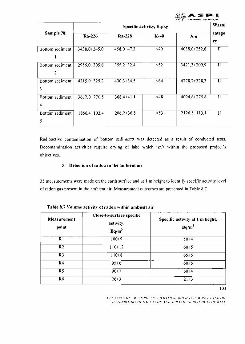
&&mrmm Q-$T C I... III., tl.l.0.rl.l.C.
Specific activity, Bqlkg 7 Sample NE
Bottom sediment
Bottom sediment
2
Bottom sediment
3
Bottom sediment
Radioactive contamination of bottom sediments was detected as a result of conducted tests.
Decontamination activities require drying of lake which isn't within the proposed project's
objectives.
4
Bottom sediment
5
5. Detection of radon in the ambient air
catego
'7'
I I
Ra-226
3438,0*245,0
2956,0*205,6
42 15,0*325,2
36 12,0*270,5
35 measurements were made on the earth surface and at 1 m height to identify specific activity level
1856,4*102,4
of radon gas present in the ambient air. Measurement outcomes are presented in Table 8.7.
Ra-228
458,0*47,2
355,2*32,4
430,3*34,5
368,4*4 1,l
206,2*36,8
K-40
<40
<52
<64
<4 8
Table 8.7 Volume activity of radon within ambient air
Aert
4038,0*252,6
<53
Measurement
point
342 1,3*209,9
4778,7*328,3
4094,6*275,8
2 26,5+
I I
I I
I I
Close-to-surface specific
activity,
Bq/m3
Specific activity at 1 m heght,
Bq/m3
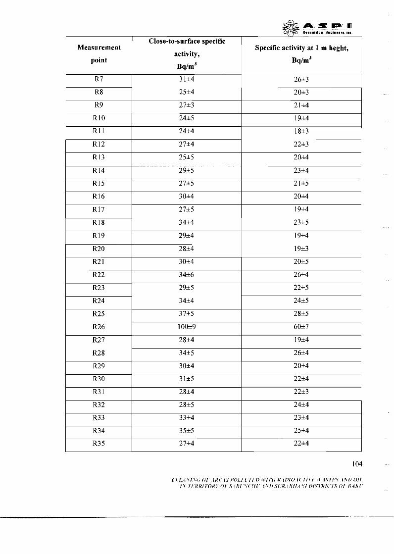
Measurement
point
Close-to-surface specific
activity,
Bq/m3
Specific activity at 1 m heght,
Bq/m3
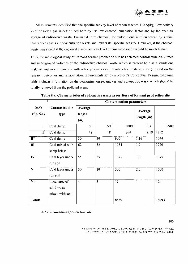
Measurements identified that the specific activity level of radon reaches 110 bqlkg. Low activity
level of radon gas is determined both by its' low charcoal emanation factor and by the open-air
storage of radioactive waste. Emanated from charcoal, the radon cloud is often spread by a wind
that reduces gas's air concentration levels and lowers its' specific activity. However, if the charcoal
waste was stored at the enclosed places, activity level of emanated radon would be much higher.
Thus, the radiological study of Ramana former production site has detected considerable on-surface
and underground volumes of the radioactive charcoal waste which is present both as a standalone
material and in combination with other products (soil, construction materials, etc.). Based on the
research outcomes and rehabilitation requirements set by a project's Conceptual Design, following
table includes information on the contamination parameters and volumes of waste which should be
totally removed from the polluted areas.
Table 8.8. Characteristics of radioactive waste in territory of Ramani production site
1 I Contamination parameters
N?N? I Contamination Average 1 7 (fig. 5.1)
- length ~ Average
length (m)
I
1 I Coal dump 60 50 3000 3-1
11'
11"
8. I . 1.2. Surakhani production site
105
111
IV
V
V I
Total:
( 1 1 I Z I l C O I I K I 1 S f ' O I L I I L I ~ I l l l l l K ~ 1 f ~ 1 0 1 ( 1 1 1 1 M 1 S I I \ 1 l f ) O I I I\ I 1 R R I 7 0 R l 0 1 S i I 3 ( \ ( I l l I % [ ) S ( It 4 k I l (\I f ) l . S I R I ( I S 0 1 8 l h f
Coal dump
Coal dump
Coal mixed with
scrap bricks
Coal layer under
run soil
Coal layer under
run soil
Local area of
solid waste
mixed with coal
4 8
30
62
55
50
4
18
30
3 2
25
10
3
864
900 1,16
1984
1375
500
12
8635
1'9
1 ,o
2,o
1
3770
1375
1000
12
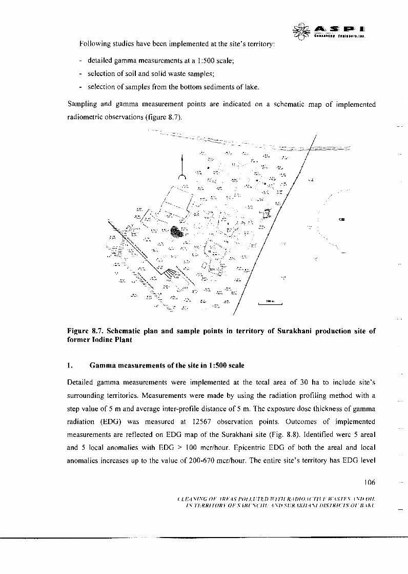
V Following studies have been implemented at the site's territory:
- detailed gamma measurements at a 1500 scale;
- selection of soil and solid waste samples;
- selection of samples from the bottom sediments of lake.
Sampling and gamma measurement points are indicated on a schematic map of implemented
radiometric observations (figure 8.7).
Figure 8.7. Schematic plan and sample points in territory of Surakhani production site of former Iodine Plant
1. Gamma measurements of the site in 1:500 scale
Detailed gamma measurements were implemented at the total area of 30 ha to include site's
surrounding territories. Measurements were made by using the radiation profiling method with a
step value of 5 m and average inter-profile distance of 5 m. The exposure dose thickness of gamma
radiation (EDG) was measured at 12567 observation points. Outcomes of implemented
measurements are reflected on EDG map of the Surakhani site (Fig. 8.8). Identified were 5 areal
and 5 local anomalies with EDG 2 100 mcrlhour. Epicentric EDG of both the areal and local
anomalies increases up to the value of 200-670 mcrlhour. The entire site's territory has EDG level
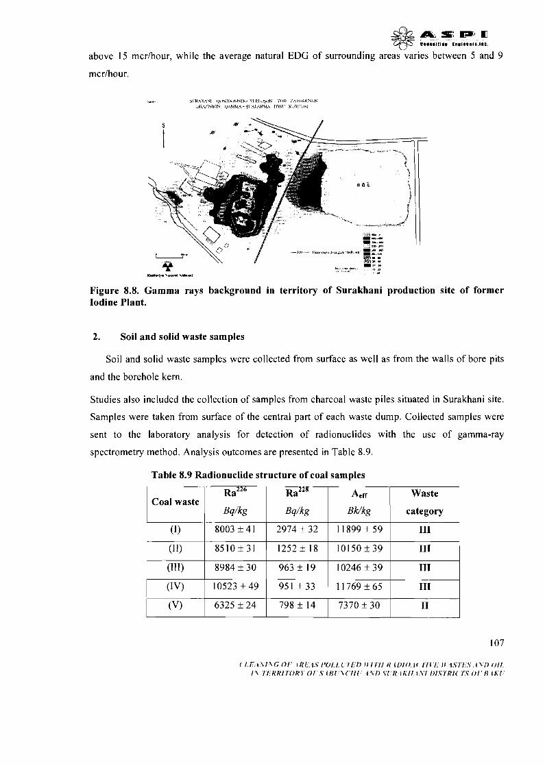
' L 2
above 15 mcrlhour, while the average natural EDG of surrounding areas varies between 5 and 9
mcrlhour.
Figure 8.8. Gamma rays background in territory of Surakhani production site of former Iodine Plant.
2. Soil and solid waste samples
Soil and solid waste samples were collected from surface as well as from the walls of bore pits
and the borehole kern.
Studies also included the collection of samples from charcoal waste piles situated in Surakhani site.
Samples were taken from surface of the central part of each waste dump. Collected samples were
sent to the laboratory analysis for detection of radionuclides with the use of gamma-ray
spectrometry method. Analysis outcomes are presented in Table 8.9.
Table 8.9 Radionuclide structure of coal samples

According to spectral analysis results, tested charcoal waste refers to 1i-gnd 111 radiation hazard
categories and requires total removal from the contaminated sites. Produced outcomes are
interpreted in a way similar to those of the Ramani site.
Picture 8. 9. Takink of sample from Soils and other solid wastes.
In order to identify the radioactivity level of buildings, construction materials and debris, samples
have been taken from bricks, concrete, cement and other solid materials contained in the production
site. Collected samples were sent to radionuclide analysis, results of which are presented in Table
Table 8.10 Radio-nuclid structure of coal, land, lime and construction materials
samples
Sample Nc Specific activity, Bqlkg Waste
categon 1 I I I I I
N2 (scale)
N3 (scale)
N4 (scale)
N 1 (scale)
I
1 220,0*8,0
22 1,0*12,0
269,5*30,1
127,0*4,7
I I I I
-- 197,0*7,0
--
N7 (scale)
N8 (scale)
47,5*6,1
26,3*7,1
5,3* 1,6
N5 (scale)
-- I
17,3*2,2
23 1,5*12,6
N6 (scale)
108 .-
261,9*23,4
23 1,4*20,4
<83,6
<6 5
76,2*34,1
<48
260,6*13,5 22,2*3,6
<62
<76,3
294,5* 15,l 255,8*14,1
22,8&4,5
25,3&5,1
283,0&14,0
3 10,4*3 1,6
134,0*6,0
29,5*4,2
--
--
--
<6 1
<74
29 1,8*24,1
264,5*2 1,5
--
--
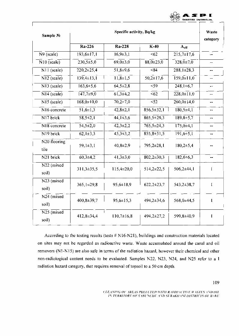
Sample Ng
N9 (scale) I I I I I
Waste
category
I
Specific activity, Bq/kg
193,6* 17,l
N I0 (scale)
N 1 I (scale)
N 12 (scale)
1 N13 (scale)
1 N14 (scale)
N I5 (scale)
I I
I N17 brick 58,5*2,1 44,1*3,6 1 865,5*29,3 1 8 9 , 8 * - 7 ~
Ra-226
16,9*3,1
230,5*5,0
220,2*25,4
139,4*13,1
163,6*5,6
I
Ra-228 K-40
147,7*9,0
168,0110,O
N16 concrete 1 51,6*1,3
Aerr
<62
69,0*3,0 1 88,0*23,0 1 328,0*7,0
5 1,8*9,6
11,8+1,5
64,5*2,8
I I I I
--
42,8*2,1
N 18 concrete 1 54,5*2,0 I I I I I I
215,7*17,6
< 84
228,0+ 1 1 ,O 6 1,3*4,2
42,3*2,2 / 765,5*24,3 1 175,0+4,1 1 N 19 brick
N20 flooring
tile
N2 1 brick
N22 (mixed
soil)
--
- 50,2* 17,6
<5 9
<62
856,5*32,1
-- I
N23 (mixed
soil)
70,2*7,0
62,1*3,3
59,1*3,1
60,3*4,2
3 1 1,3*35,5
N24 (mixed
soil)
According to the testing results (tests # N 16-N21), buildings and construction materials located
on sites may not be regarded as radioactive waste. Waste accumulated around the canal and oil
removers (Nl-N15) are also safe in terms of the radiation hazard, however their chemical and other
non-radiological content needs to be evaluated. Samples N22, N23, N24, and N25 refer to a I
radiation hazard category, that requires removal of topsoil to a 50 cm depth.
159,0~11,0
248,1*6,7
<52 260,0*14,0
180,5*4,1
40,8*2,9 795,2*28,1 180,22:5,4
4 1,3*3,0 802,2*30,3 182,6*6,3
1 15,4*20,0 5 14,2*22,5 1 506,2*44,1
365,1*29,8
N25 (mixed
1 soil)
--
--
--
43,3*3,2
95,6*18,9 622,2*23,7 543,2*38,7
400,8*39,7 95,6* 15,3 I
412,8*34,4
855,8*31,5 1 191,6*5,1
494,2*27,2 599,8*4n,')I
--
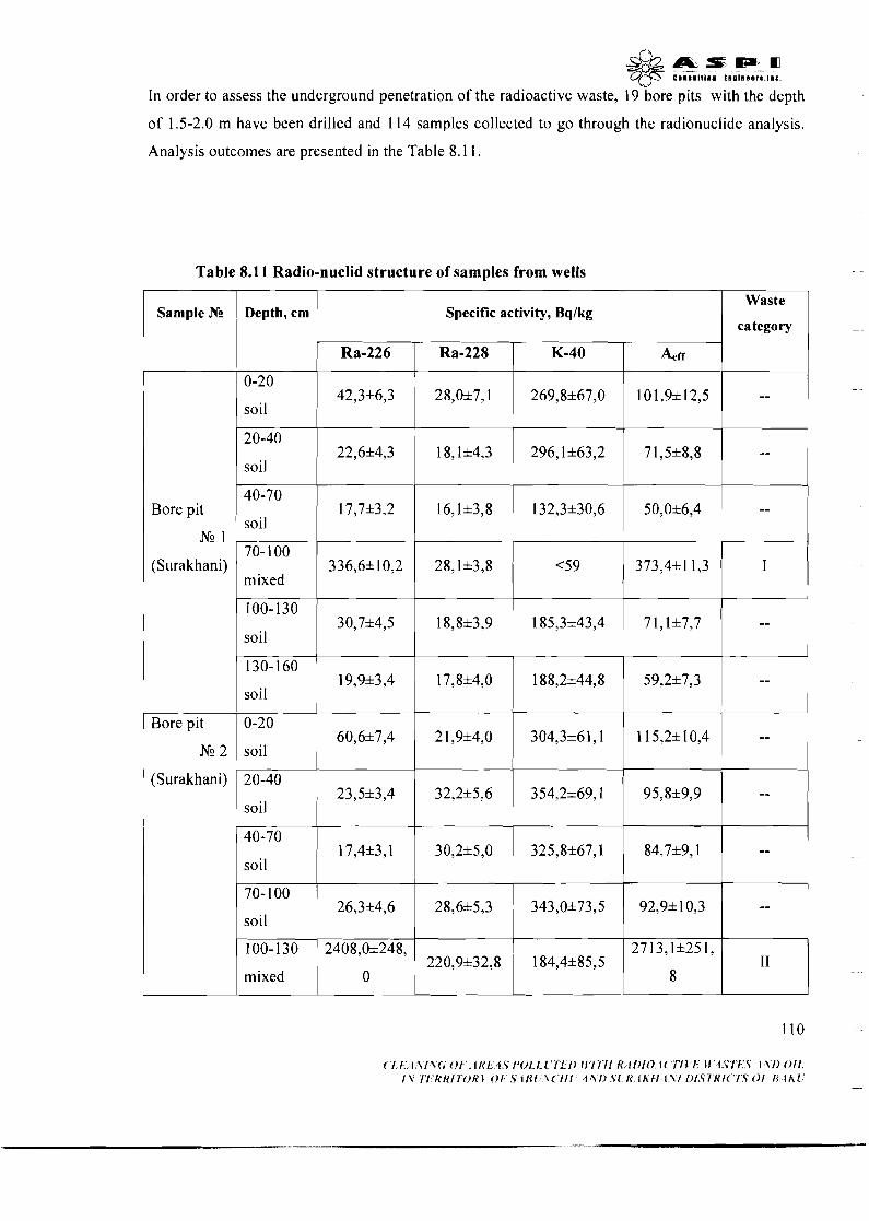
& A & = m = m C)(SFS C I O S I I I I I I € O D l O O O ~ l . l O D .
In order to assess the underground penetration of the radioactive waste, 19 bore pits with the depth
of 1.5-2.0 m have been drilled and 114 samples collected to go through the radionuclide analysis.
Analysis outcomes are presented in the Table 8.1 1.
Table 8.11 Radio-nuclid structure of samples from wells
Sample Nc , Depth, cm 1 Specific activity, Bqlkg Waste
category
0-20
soil
20-40
soil
Bore pit
N9 1
(Surakhani)
1 soil I I I I I
42,3*6,3
22,6&4,3
100-130
soil
-- Bore pit 0-20
304,3*61,1 115,2&10,4 -- Nc 2 soil
- 40-70
soil --
70- 100
mixed
28,0&7,1
1 8,1&4,3
30,7&4,5
1 mixed I
I
(Surakhani) 20-40 23,5&3,4 32,2+5,6 354,2&69,1 95,8&9,9 --
soil -- --- 40-70
269,8&67,0
296,1&63,2
--
I
I
18,8+3,9 185,3143,4
I soil
50,0&6,4
373,4*11,3
17,7&3,2 132,3&30,6
I
101,9& 12,5
7 1,5+8,8
336,6*10,2
7 1,1*7,7
17,4*3,1
--
--
--
28,1+3,8
30,2&5,0
<59
325,8*67,1 84,7*9,1 --

Sample .Nc
I
Waste
category Depth, cm Specific activity, Bq/kg
1 Ra-226
Bore pit
N9 3
Ra-228
39,8*5,4 130- 170
mixed
0-20
coal
20-40 1 11,70,6 1 3,30,4 1 42,9*5,9 1 19,7&0,9 1 -- soil
32 1,2*40,1
K-40
223,3*74,6
1769,0* 184,
0
Aerr
392,3*4 1,2
(Surakhani)
Bore pit
N9 4
(Surakhani)
8 1,9* 17,6
N? 3
(Surakhani)
Bore pit
N9 5
, mixed
40-70
100-130
Soil
130-170
soil
0-20
soil
100-130 1 I4,2&1,3 6,7*0,9 1 107,6&13,7 1 32,1*2,1 1 -- soil
I1 200,8*83,4
283,1&6,2
40-70
Soil
70- 100
1 mixed
1893,4*185,
6
94,5&2,5
66,6*8,2
678,5*40,2
( ' I ,E/ l .Yt ,V(; O F . fl<f;.,i.S f 'Ol , t . l . ' lEt) i l ' l TI1 R, i t ) t O . 1 ( 'TI b'f: bi.4.STf;,S, 1 V l ) O f t . I.% 7'I'RH17'OH 1' OFS I R I .~!V( ' / / I ' :f.Y/.) .Sl:R, I KII.1.VI L~I.S7~HI('l:S O f ' R 1 h ' I '
8,2& 1,8
44,6&6,6
27,8*2,4
130- 160
soil
14,3* 1,2
37,6*5,7
44,8&6,1
87,3&25,6
48,6*9,1
18,2*1,8
14,9*1,5
I
130,2&15,0
440,9*84,7
I
192,5&32,2
0: 1 176,0&40,0
301,3*7,0
313,9*71,1
9,9*0,8
--
124,3&3,2
153,3* 13,l
753,6&41,1
135,0*14,8
8,2*5,7
--
--
1
220,0127,O 1 70,3+4,0
I 1 1,7&1 l,5
<63
37,4*2,1 --
3 186,7*40,8 I 1
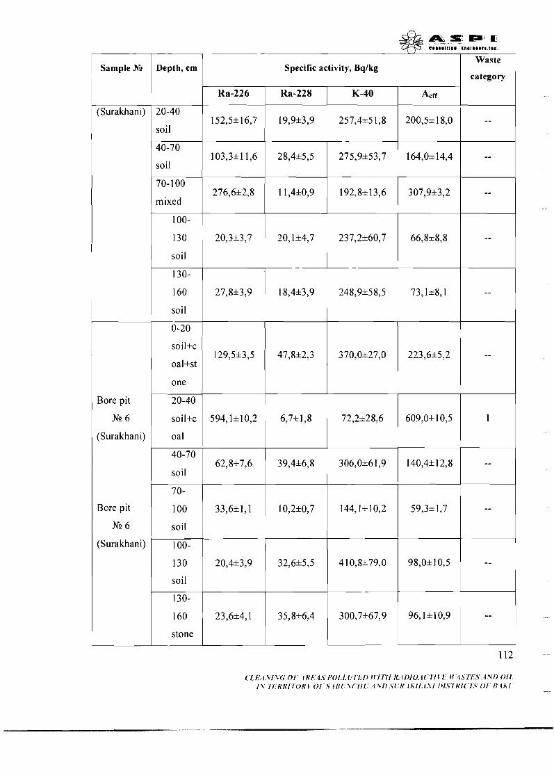
Sample Ne Depth, cm
soil
1 40-70
soil
70- 1 00
mixed
soil
130-
160
soil
0-20
soil+c
oaI+st
one
Bore pit
Nc 6
(Surakhani)
Bore pit
Nc 6
(Surakhani)
40-70
soil
soil
soil
130-
160
stone
Waste
category Specific activity, Bqlkg
Ra-226 Aeff Ra-228 K-40
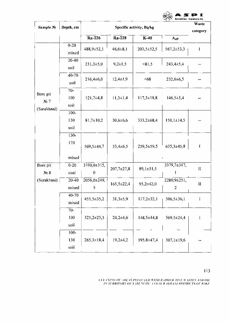
Sample M
Bore pit
N2 7
(Surakhani)
Bore pit
Nc 8
(Surakhani)
Depth, cm
0-20
mixed
20-40
soil
soil
70-
100
soil
100-
130
soil
mixed
coal
20-40
mixed
@& ..i f lp. I 1 q-jS earn11111111 ino tnears . l ac .
Specific activity, Bqlkg --pic
40-70
mixed
70-
100
soil
100-
130
soil
Ra-226
488,9*52,1
23 1,3*5,0
2 16,4*6,0
121,7*4,8
8 1,7* 10,2
569,5*44,7
3 100,0+3 15, 207,7*27,8 89,1*5 1,5
0 1
- Aerr
567,2*53,3
243,4*5,4
232,6*6,5
146,5*5,4
150,1*14,5
635,3+45,8
3379,7*3 17,
category
I
--
--
--
--
I
Ra-228
46,6*8,1
9,2*1,5
12,4*1,9
11,3*1,4
30,6*6,6
33,4*6,5
K-40
203,5*52,5
<8 1,5
<68
117,5*18,8
333,2*68,4
259,5+59,5
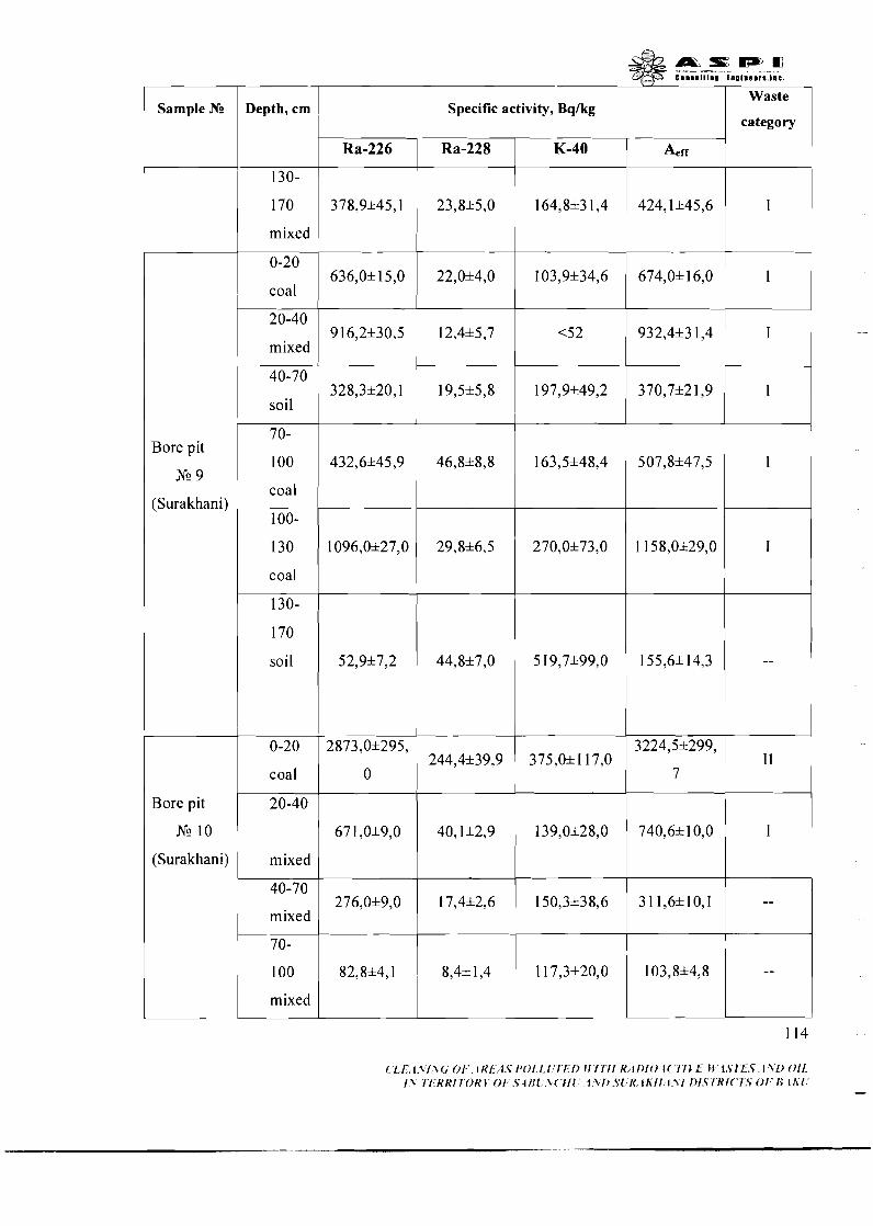
Sample Ng Depth, cm Specific activity, Bq/kg Waste
category
130-
170
mixed
0-20
coal
20-40
mixed
40-70
soil
70-
100
coal
100-
130
Bore pit
N!? 9
(Surakhani)
coal
130-
170
soil
Bore pit 20-40
N!? 10
(Surakhani) mixed
1 mixed
mixed

Specific activity, Bqlkg Sample .We Waste 1
Depth, crn category 1
1 loo- 130
soil
130-
160
soil
0-20
coal
1 mixed
100 Bore pit
N!? 11 1 coal
(Surakhani) 1 loo-
1 130
Bore pit
N!? 12
(Surakhani)
mixed
mixed
mixed
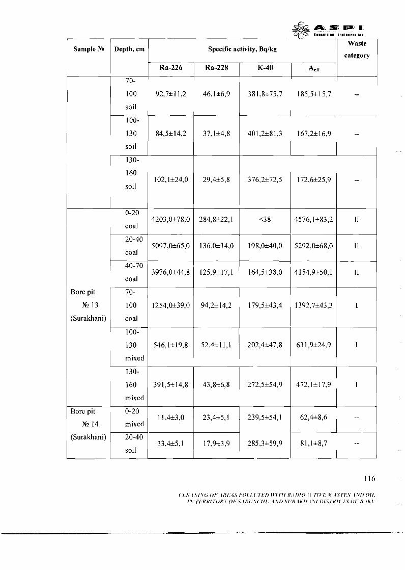
Sample Ns
Bore pit
NG 13
(Surakhani)
Bore pit
(Surakhani)
Depth, cm
70-
100
soil
100-
130
soil
130-
160
soil
coal
20-40
coal
coal
coal
100-
130
mixed
130-
160
mixed
mixed
20-40
soil
Specific activity, Bq/kg Waste
category
~ ' f , f : , l , \ f v ~ ; O / ~ . l / < f ' ~ . 4 . S f'Of.l.1 T 'L I ) l \ ' f rTf f<< l l ) fO l ( Y ' l L f ; l f : i . Y r I , Y . f . v f ) O f f . f 1 7 ' / . 'KK / l 'Oh '~ O F , F IRl.'Y('111.' 4 V l ) . S l ! N . I t i f i . I ~ f f 1)1.5'7-K/('7:F 01 . 'R : tK l -
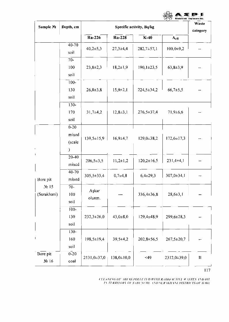
Sample M Depth, crn
soil
soil
1 soil
soil + 1 mixed
(scale
)
1 mixed
Bore pit 1 mixed
(Surakhani) 100
soil
100-
130
soil
130-
160
soil
--
Specific activity, Bqlkg Waste r.tEgo"

Sample .N2
(Surakhani)
Bore pit
N9 16
(Surakhani)
Bore pit
NG 17
(Surakhani)
Depth, cm
20-40
soil
40-70
soil
70-90
soil
90-
130
coal
130-
160
coal
160-
200
coal
0-20
coal
(m ixe
d)
20-40
mixed
40-70
mixed
70-
100
mixed
100-
130
mixed
Specific activity, Bqlkg Waste
category

Sample Ne
Bore pit
Ne 18
(Surakhani)
Depth, cm
130-
170
soil
0-20
scale
20-40
mixed
40-70
mixed
(coal
+ fuel
oil + soil)
70-
100
(coal
+ fuel
oil + soil)
IOO-
130
(coal
+ fuel
oil + soil)
Waste
category
--
I I
I1
I1
I1
I1
Aetf
1 87,6& 1 0,9
66 18,6&78,6
7829,1&74,6
4672,3&67,9
5627,Oh 1 13,
7
2614,5&98,5
Ra-226
160,4& 10,l
6554,0&77,0
7757,0&72,0
46 16,0&66,0
5556,0&112,
0
2568,0&98,0
Specific
Ra-228
6,2& 1,l
49,3& 12,l
55,0&14,8
43,Oh 12,2
54,2& 15,O
27,156,7
activity, Bq/kg
K-40
224,8&47,1
<66
<95,3
<5 8
<95
129,5&41,2
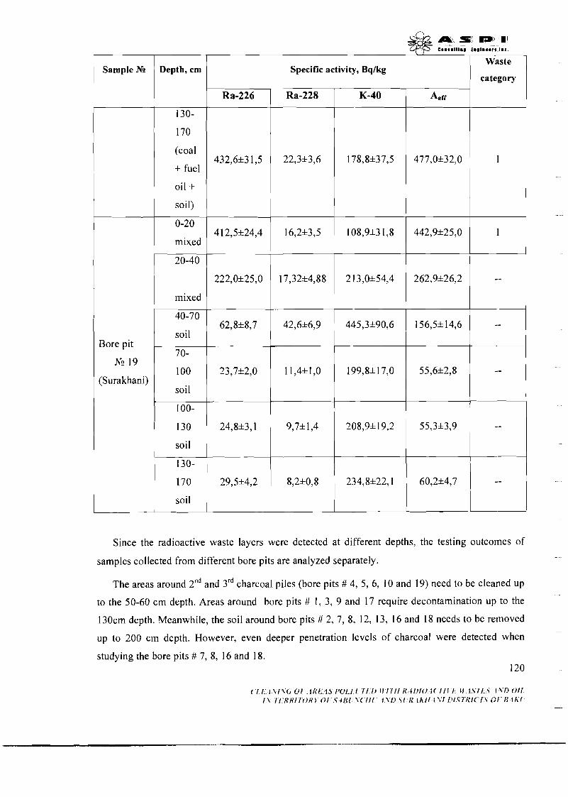
- -
Sample N!
Bore pit
Nc 19
(Surakhani)
Depth, cm
130-
170
(coal
+ fuel
oil + soil)
mixed
mixed
40-70
soil
70-
100
soil
100-
130
soil
130-
170
soil
Specific activity, Bqlkg Waste
category
Since the radioactive waste layers were detected at different depths, the testing outcomes of
samples collected from different bore pits are analyzed separately.
The areas around 2nd and 3rd charcoal piles (bore pits # 4, 5, 6, 10 and 19) need to be cleaned up
to the 50-60 cm depth. Areas around bore pits # 1, 3, 9 and 17 require decontamination up to the
130cm depth. Meanwhile, the soil around bore pits # 2, 7, 8, 12, 13, 16 and 18 needs to be removed
up to 200 cm depth. However, even deeper penetration levels of charcoal were detected when
studying the bore pits # 7, 8, 16 and 18.
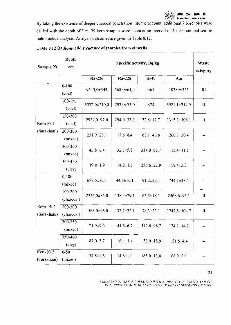
~ R I I L S ~ I ~ = ~ qj5 c .... Ill.. t..l...,'.l.. .
By taking the existence of deeper charcoal penetration into the account, additional 7 boreholes were
drilled with the depth of 5 m. 39 kern samples were taken at an interval of 50-100 cm and sent to
radionuclide analysis. Analysis outcomes are given in Table 8.12.
Table 8.12 Radio-nuclid structure of samples from oil wells
Depth
cm Waste
category
Specific activity, Bqlkg Sample Ng
Ra-228
(coal)
K-40
(coal)
Kern Nc 1
(Surakhani)
(coal)
(mixed)
300-360
(mixed)
360-450
(mixed)
100-200
(charcoal)
Kern Nc 2
(Surakhani) (charcoal)
300-350
(mixed)
Kern Nc 3
(Surakhani) (mixed)
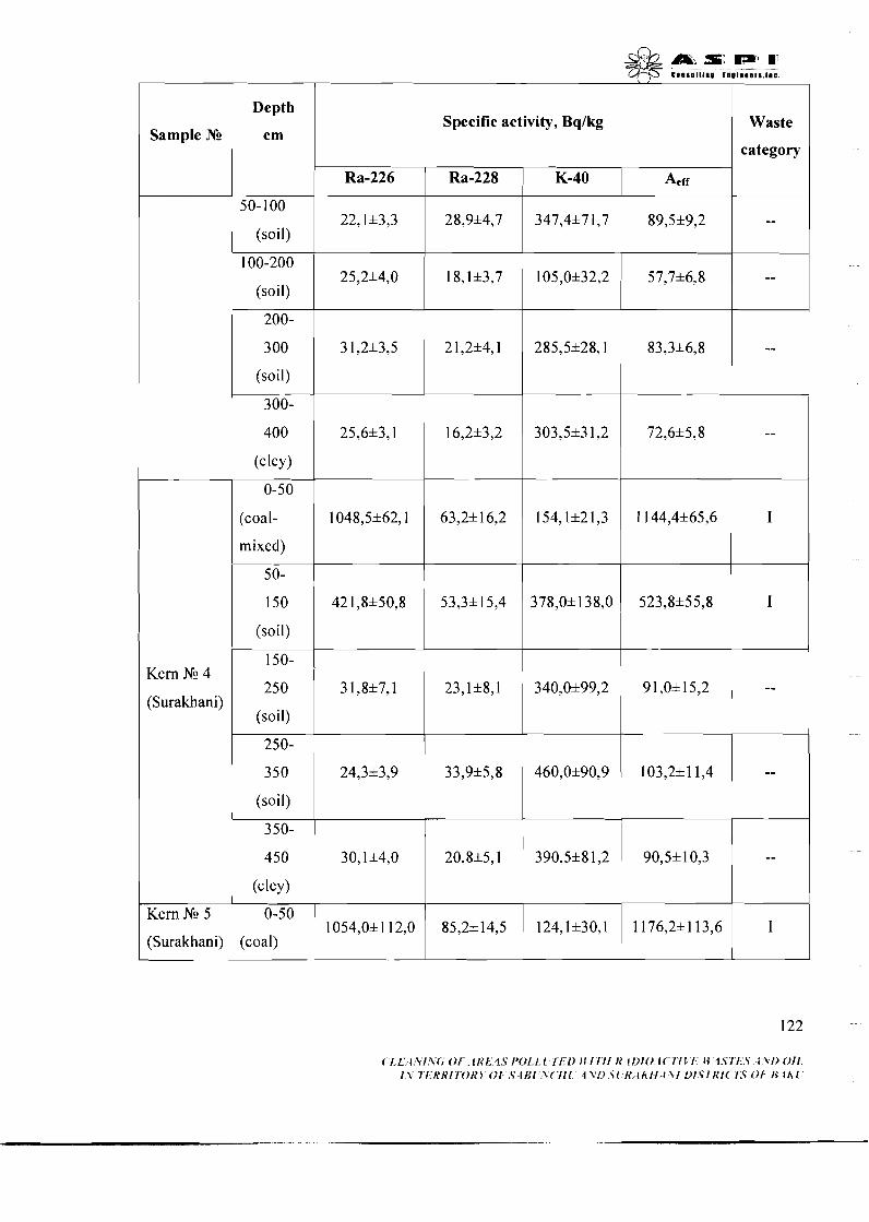
1 Depth
Sample Ng I cm
1 (soil)
(soi I)
(soil)
300-
(coal-
mixed)
(soil)
~ u ~ ~ a ~ i ) ~ (soil) :!y 1 (soil)
Kern NG 5
(Surakhani) 1 (coal)
Specific activity, Bqlkg I Waste
category
Ra-226 Ra-228 K-40 A, rr
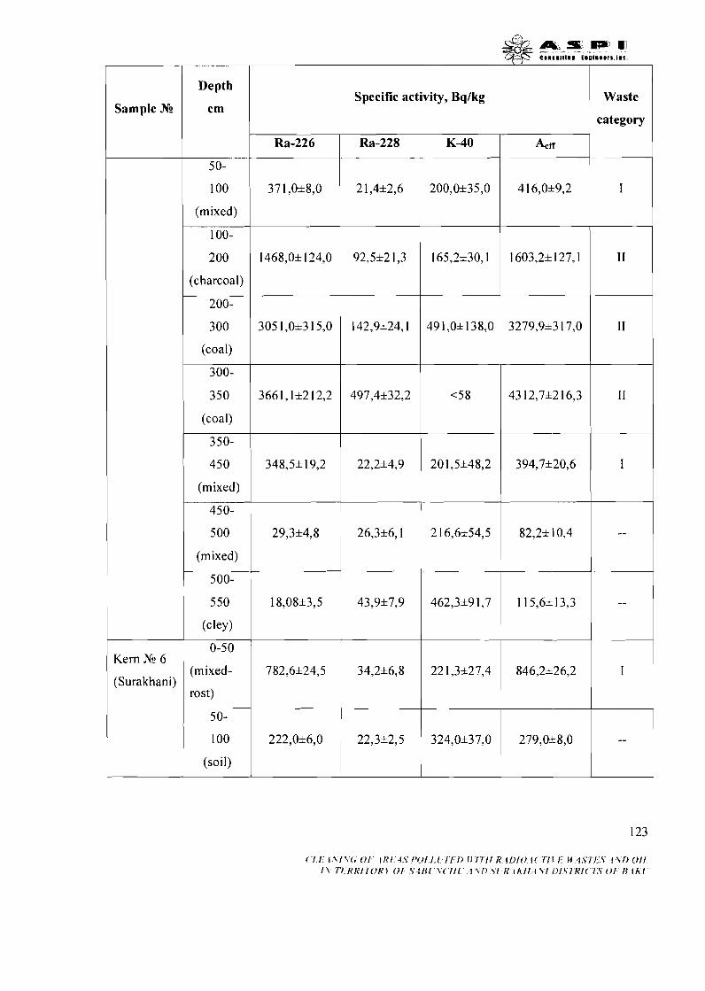
Sample .NO
Kern Nc 6
(Surakhani)
Depth
cm
100
(mixed)
100-
200
(charcoal)
200-
300
(coal)
(coal)
350-
450
(mixed)
Specific activity, Bqlkg Waste
category
450-
5 00
(mixed)
500-
(mixed-
5 0-
100
(soil)
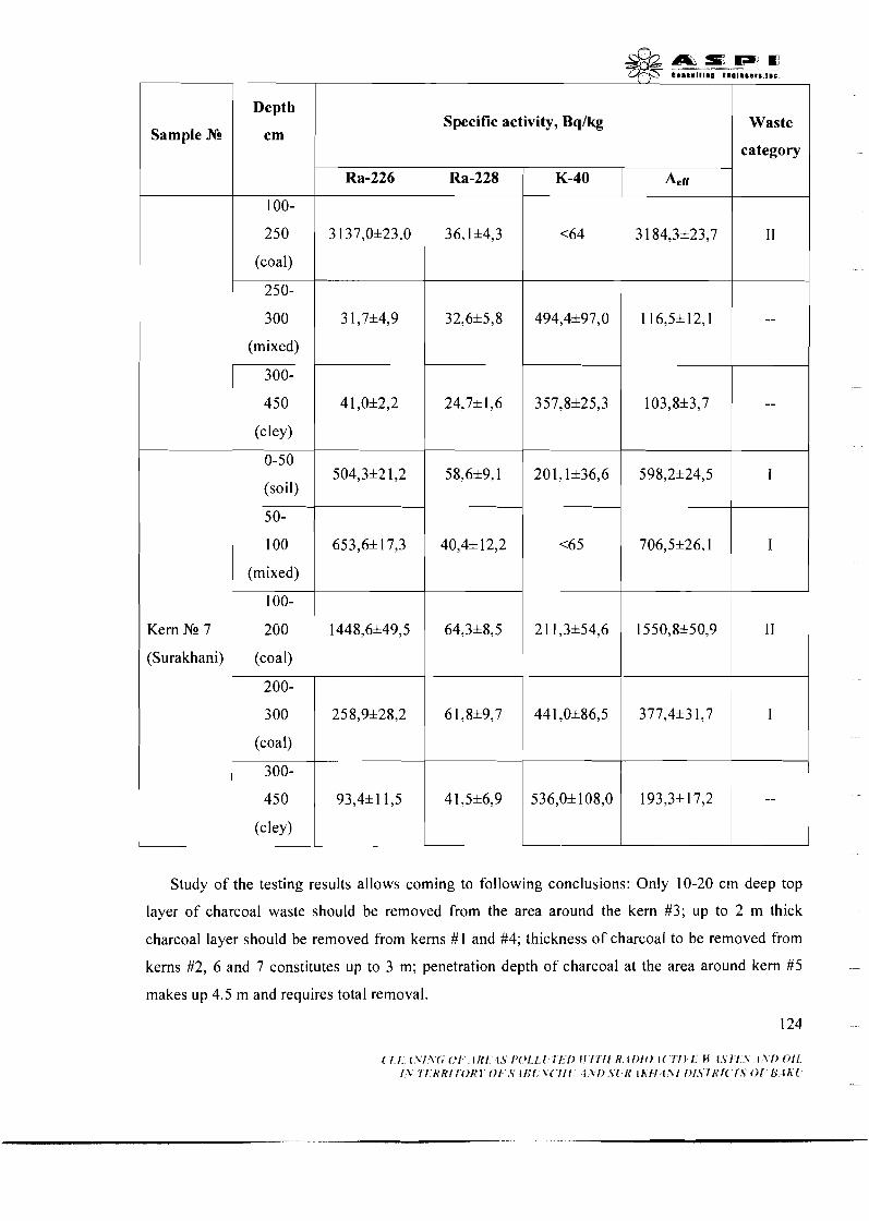
Sample N!
Kern Nc 7
(Surakhani)
Depth
cm
100-
250
(coal)
250-
300
(mixed)
300-
450
(cley)
(soil)
(mixed)
100-
Specific activity, Bqlkg Waste
category
Study of the testing results allows coming to following conclusions: Only 10-20 cm deep top
layer of charcoal waste should be removed from the area around the kern #3; up to 2 m thick
charcoal layer should be removed from kerns #I and #4; thickness of charcoal to be removed from
kerns #2, 6 and 7 constitutes up to 3 m; penetration depth of charcoal at the area around kern #5
makes up 4.5 m and requires total removal.
200-
3 00 258,9&28,2 61,8&9,7 441,0&86,5 377,4&3 1,7
(coal)
300-
450
( ~ l e y )
93,4*11,5
pppp
41,556,9 536,0&108,0 193,3*17,2 --
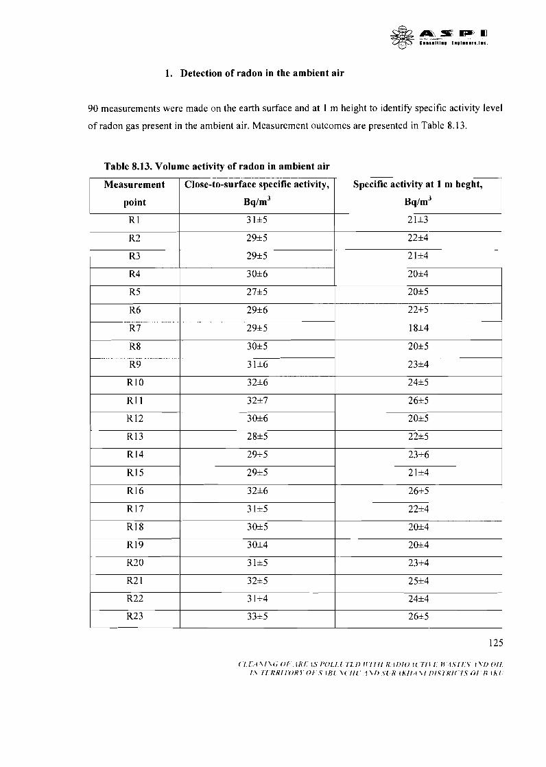
1. Detection of radon in the ambient air
90 measurements were made on the earth surface and at 1 m height to identify specific activity level
of radon gas present in the ambient air. Measurement outcomes are presented in Table 8.13.
Table 8.13. Volume activity of radon in ambient air
Specific activity at 1 m heght,
Bq/m3
21*3
22*4
21+4
2054
20+5
22+5
18*4
20*5
23+4
24+5
26*5
20*5
22*5
23+6
21+4
26+5
22+4
20*4
20+4
23+4
25+4
24*4
26+5
Measurement
point
R 1
R2
R3
R4
R5
R6
R7
R8
R9
RI 0
R11
R 12
R13
R14
R15
R16
R17
RI 8
R19
R20
R2 1
R22
R2 3
Close-to-surface specific activity,
Bq/m3
3 1+5
29+5
29*5
30+6
27*5
29+6
29*5
30*5
3 1*6
32*6
32+7
30*6
28*5
29+5
29+5
32*6
3 1*5
30+5
3 0*4
3 1+5
32+5
3 1+4
33+5
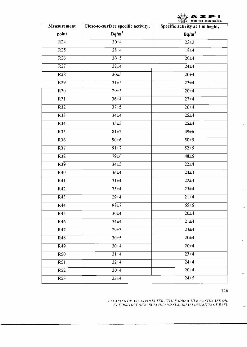
I point
S;_m m E l l S l l l l l D t n l l B l l r t . l l e .
Measurement Close-to-surface specific activity, Specific activity at 1 m heght,
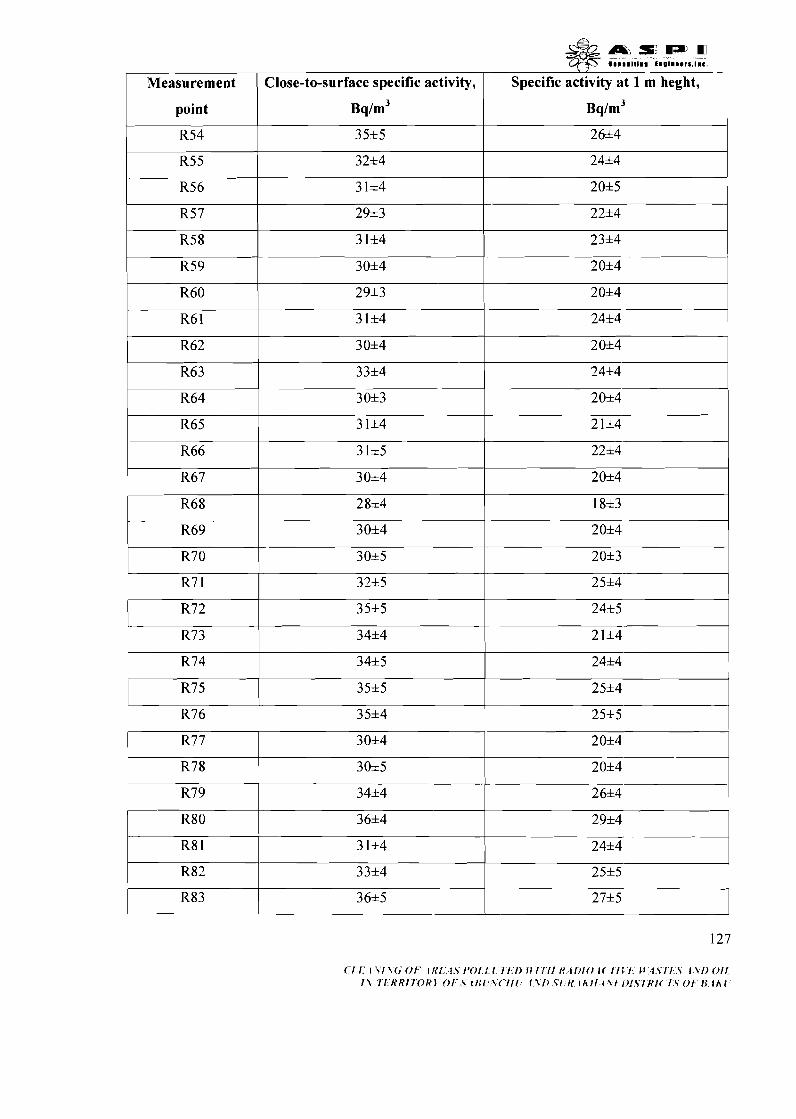
point I ~ q / r n ~
I
Measurement ( Close-to-surface specific activity, Specific activity at 1 m heght, 7

Measurements determined that the specific activity level of radon reaches 98 bqlkg. Low
activity level of radon gas is determined both by its' low charcoal emanation factor and by the
open-air storage of radioactive waste. Emanated from charcoal, the radon cloud is often spread by a
wind that reduces gas's air concentration levels and lowers its' specific activity. However, if the
charcoal waste was stored at the enclosed places, activity level of emanated radon would be much
higher.
Measurement
point
R84
R8 5
R86
R87
R88
R89
R90
Thus, the radiological study of Surakhani production site has also detected considerable on-surface
and underground volumes of the radioactive charcoal waste which is present both as a standalone
material and in combination with other products (soil, construction materials, etc.). Based on the
research outcomes and rehabilitation requirements set by a project's Conceptual Design, following
table includes information on the contamination parameters and volumes of waste which should be
totally removed from the polluted areas.
Close-to-surface specific activity,
Bq/m3
35*4
30*4
30*5
30*4
30*5
32*4
36*4
\ I
Specific activity at 1 m heght,
Bq/m3
25*5
20*4
20*4
20*3
20*4
25*5
27*4
Table 8.14. Characteristic of the radioactive waste in Surakhany production site
- -
N2N2
(fig-
5.1)
Coal dump
Contamination type
Coal dump
Contamination parameters
Average
length (m)
75
0 s
Average
length (m)
3,5
40
13125
400 -----
3750
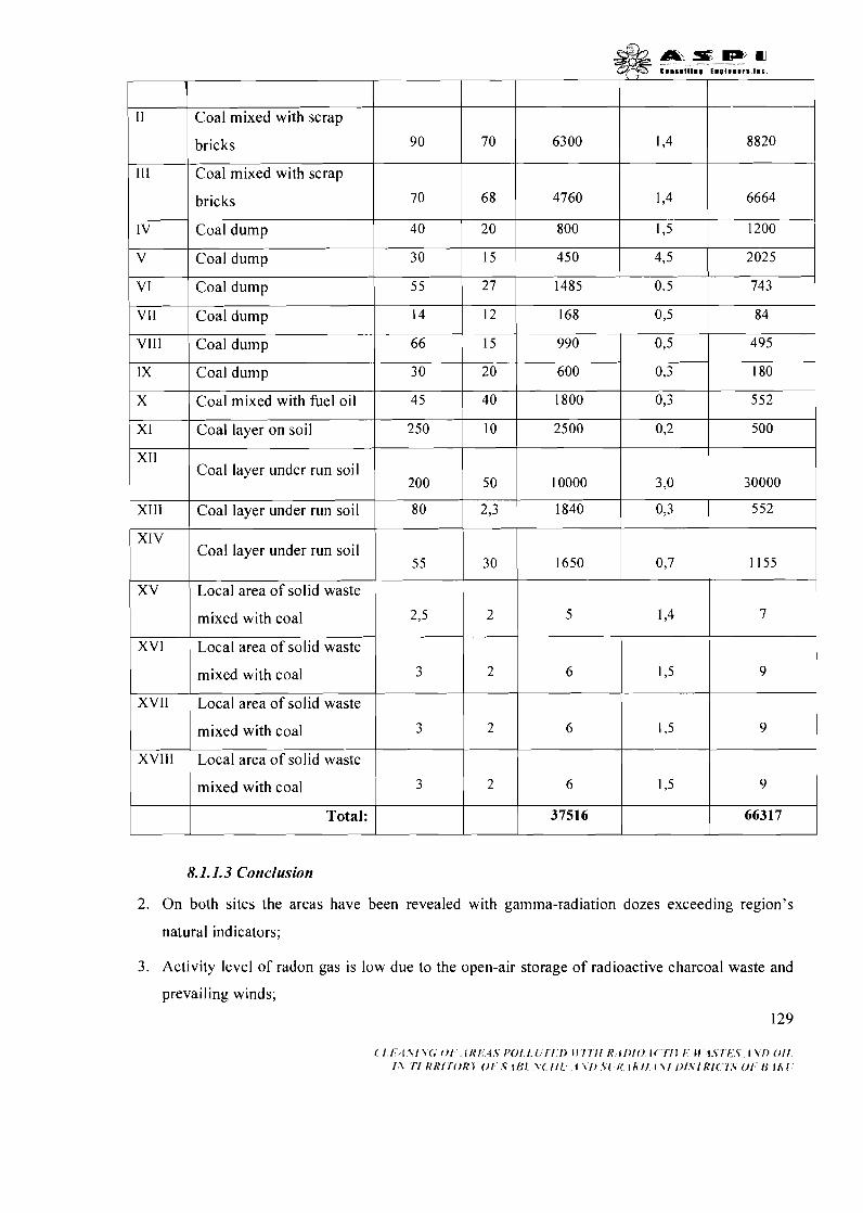
I I I I I I
V I 1 Coal dump 55 27 1485 O,5 743 1
8820
6664
1200
1 1 Coal layer under run soil 1 200 1 50 I0000 1 3.0 1 30000 1
I V I Coal dump 1 30 1 1 5 ) 450 1 4,5 1 2025 1
VII
VIIl
1X
X
I
70
6 8
20
90
70
40
I
11
111
IV
Coal mixed with scrap
bricks
Coal mixed with scrap
bricks
Coal dump
Coal dump
Coal dump
Coal dump
Coal mixed with fuel oil
Coal layer on soil
I I I I I I
6300
4760
800
XIV
XV
XVII Local area of solid waste
I
1,4
1,4
1,5
14
66
30
4 5
250
552 Xlll 1 Coal layer under run soil I 8 0 1 2,3 1 1840
XVI
mixed with coal
0,3
Coal layer under run soil
I
XVIII Local area of solid waste I
12
15
20
40
10
mixed with coal
mixed with coal
Local area of solid waste , 55
8.1.1.3 Cortclusion
2. On both sites the areas have been revealed with gamma-radiation dozes exceeding region's
natural indicators;
3 . Activity level of radon gas is low due to the open-air storage of radioactive charcoal waste and
prevailing winds;
129
( ' 1 . /:/I Y I \-<; 0 1 , " . i 1~I ; ; t . s IJ0J"1" l ! I ' I : i ) I!'/ 7 1 1 f f . I I ) / ( . ) l< 7 7 I 1.: If 1.s7.K.s. I \ 1) 0 1 1 . I\ T l . f f R l r O R j 0 F . V l l j i \( 111.' I \ l ) . Y l ' i < l l i 1 f . t \I / ) l .V lRI ( . ' l :S OF13 t K [ '
168
990
600
1800
2500
2,5
3 0
Local area of solid waste
mixed with coal
O,5
0,5
0,3
0,3
0 2
1,4
84
495
180
552
500
1650
3
7
0,7
2 1,5 6 9

&A&s:wrn z@ ...t.Ll.. E"@l.88,t.I.C.
4. There are accumulated radioactive waste refer to I, I1 and I11 radiation hazard categories on the
Plant site;
5. Therefore, production waste on the two plant sites is classified as radiologically hazardous and
disposed according to the national and international long-lived low-level waste management
standards existing in Azerbaijan Republic;
6. Buildings, reinforced concrete structures and other construction material do not belong to a
radioactive waste category for having Aeff I 370 bq/kg. Therefore, this kind of waste may go to
the usual landfills;
7. Standalone superficial and underground charcoal waste volumes as well as waste volumes
combined with other materials (construction materials, soil, etc.) should be disposed at the
special underground disposal facility designed for storage of long-lived low-level waste. Total
estimated volume of radioactive waste makes up 853 10 m3 (1 8993 m3 in Ramani, and 66377 m3
in Surakhani site);
8. Asbestos pipes of the drainage system from both sites contain radioactive scale and also should
be disposed in the underground disposal facility. Silt and chemical deposits accumulated on
pipes' inner walls refer to I and I1 radiation hazard category. Pipes with the section of 0.1-0.5 m
will be excavated together with contaminated soil and disposed together with other radioactive
waste according to relevant national standards. Total estimated length of pipelines is 2000
running meters.
8.1.2. Oil contamination
Areas contaminated with fuel oil, bitumen and oil products have been identified on both production
sites during the assessment (see fig. 8.1 and 8.2). Following paragraphs describe the outcomes of
implemented studies.
8.1.2.1. Ramani production site
Following field studies have been implemented in production site:
Collection of oil polluted ground samples from bore pits and boreholes to identify their
pollution level;
Collection of groundwater samples in order to identify their oil pollution status.
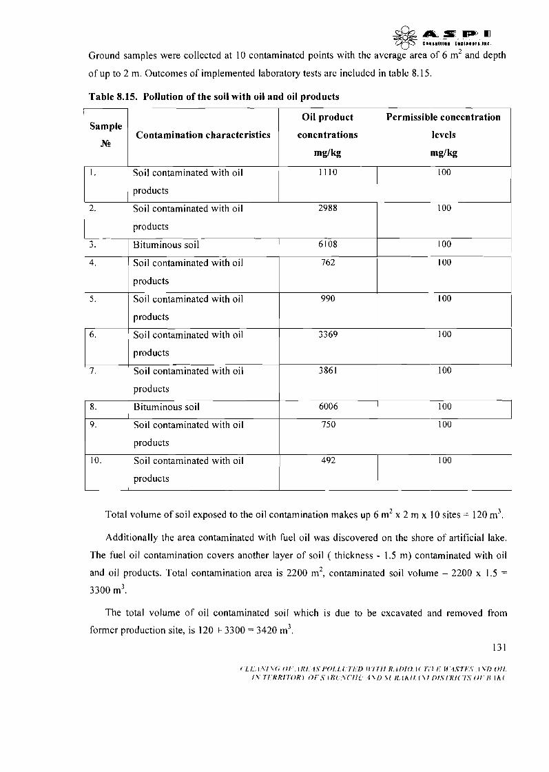
& m z D P m (;t-_35 C l l l l l l l l l I l l l l l 8 D f t I # ( .
Ground samples were collected at 10 contaminated points with the average area of 6 m2 and depth
of up to 2 m. Outcomes of implemented laboratory tests are included in table 8.15.
Table 8.15. Pollution of the soil with oil and oil products
I I I
I I products I I
Sample
N2
1.
Contamination characteristics
Oil product
conentrations
1 products
Permissible concentration
levels
Soil contaminated with oil 1 1 10 ~ 2988 2.
? J .
4.
I I products I I I
100
100 Soil contaminated with oil
products
contaminated with oil
Bituminous soil
Soil contaminated with oil
990
Total volume of soil exposed to the oil contamination makes up 6 m2 x 2 m x 10 sites = 120 m3.
6108
762
6. 1 Soil contaminated with oil
9.
10.
Additionally the area contaminated with fuel oil was discovered on the shore of artificial lake.
The fuel oil contamination covers another layer of soil ( thickness - 1.5 m) contaminated with oil
and oil products. Total contamination area is 2200 m2, contaminated soil volume - 2200 x 1.5 =
3300 m3.
100 I
100
3369
3861
6006
7.
8.
The total volume of oil contaminated soil which is due to be excavated and removed from
former production site, is 120 + 3300 = 3420 m3.
13 1
100
100
100
products
Soil contaminated with oil
products
Bituminous soil
Soil contaminated with oil
products
Soil contaminated with oil
products
750
492
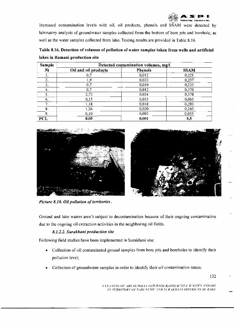
\-' Increased contamination levels with oil, oil products, phenols and SSAM were detected by
laboratory analysis of groundwater samples collected from the bottom of bore pits and borehole, as
well as the water samples collected from lake. Testing results are provided in Table 8.16.
Table 8.16. Detection of volumes of pollution of water samples taken from wells and artificial
lakes in Ramani production site
Picture 8.1 0. Oil pollution of territories .
Sample N 2
1. 2. - 3. 4. 5. 6. 7. 8. 9.
PCL
Ground and lake waters aren't subject to decontamination because of their ongoing contamination
due to the ongoing oil extraction activities in the neighboring oil fields.
8.1.2.2. Surakhani production site
Following field studies have been implemented in Surakhani site:
Collection of oil contaminated ground samples from bore pits and boreholes to identify their
pollution level;
Collection of groundwater samples in order to identify their oil contamination status.
Detected contamination volumes, mgn Oil and oil products Phenols
037 0,012 1,9 0,7 0,7 2,73 0,15 1,18 1,26 0,lO 0,05
0,O 10 0,012 0,034 0,053 0,O 18 0,020 0,003 0,001
0,235 0,370 0,378 0,065 0,293 0,245 0,055
075
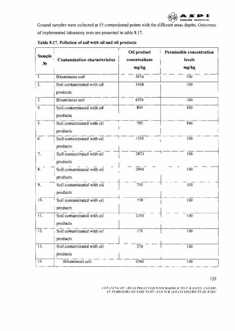
& & a r : m w m +JF C~IIII I I I~ t n o l w a a r s . ~ ~ ~
Ground samples were collected at 15 contaminated points with the different areas depths. Outcomes
of implemented laboratory tests are presented in table 8.17.
Table 8.17. Pollution of soil with oil and oil products
1 Bituminous soil I 5676 I 100
Sample
N!2
~ 1 products 1 1
Contamination characteristics
I I I
2. 1 Soil contaminated with oil
Oil product
conentrations
m g / k
3468 I 100
I I I I
I I products I I
Permissible concentration
levels
m g / k
1 3. ( Bituminous soil 1 I I
I 5 . I Soil contaminated with oil
4. 1 Soil contaminated with oil
6501
I products
100
894
6.
1 7 Soil contaminated with oil
100
products
Soil contaminated with oil
Soil contaminated with oil l l products
Soil contaminated with oil . ~ 1 products 1 10. 1 Soil contaminated with oil I 73 8 I 100
11.
products
I products
12. ( Soil contaminated with oil
products
Soil contaminated with oil 1350 100
171 100
, 14. 4560
products
Bituminous soil -
100
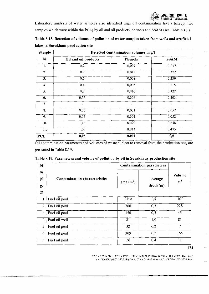
& a _ . s m a qyi E..l.lll., II,,I.L.r'.llL.
Laboratory analysis of water samples also identified high oil contamination levels (except two
samples which were within the PCL) by oil and oil products, phenols and SSAM (see Table 8.18.).
Table 8.18. Detection of volumes of pollution of water samples taken from wells and artificial
lakes in Surakhani production site
Sample S g l l I I 1 N. Oil and oil product^^ Phenols SSAM
1 1 1 . 1 1,03 0,014 1 0::5 1 PCL 0,05 0,001 L- I I I Oil contamination parameters and volumes of waste subject to removal from the production site, are
presented in Table 8.19.
Table 8.19. Parameters and volume of pollution by oil in Surakhany production site
I I 1 Contamination parameters 1 I
Contamination characteristics
1 2 Fuel oil pool I I I I
760 0 228
I I I
area (m2)
1 1 Fuel oil pool
3
1 5
6
7
average
depth (m)
2140
Volume
m3
Fuel oil pool
Fuel oil well
Fuel oil pool
Fuel oil pool
Fuel oil pool
0,5 1070
150
8 1
3 2
309
26
0,3
1 ,o
0 2
0,5
0,4
4 5
8 1
7
155
l 1 I
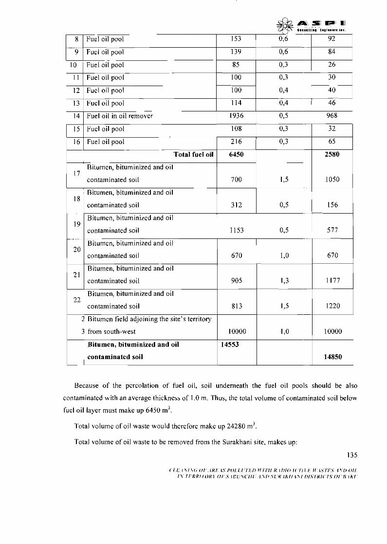
i i
I I I I 1 11 I Fuel oil pool 100 0,3 ,301
I I I I
0,6 92
I I I
13 1 Fuel oil pool 114 0,4 71
153 8
9 I Fuel oil pool
I I
Fuel oil pool
0,6 139 84
40 1 12 1 Fuel oil pool
I I I
1 I I
16 1 Fuel oil pool 216 0,3 -1 I I
100
14
0,4
1936 Fuel oil in oil remover
0,3 32 1 I5 Fuel oil pool
I I I
0,5
108
Total fuel oil 6450
17 1 18
19
I I
Bitumen field adjoining the site's territory
7 00
Bitumen, bituminized and oil
contaminated soil
20
2 1
22
1,5
Bitumen, bituminized and oil
contaminated soil
Bitumen, bituminized and oil
contaminated soil
1 1 contaminated soil I I 1 14850 1
Bitumen, bituminized and oil
contaminated soil
Bitumen, bituminized and oil
contaminated soil
Bitumen, bituminized and oil
contaminated soil
3
Because of the percolation of fuel oil, soil underneath the fuel oil pools should be also
contaminated with an average thickness of 1.0 m. Thus, the total volume of contaminated soil below
fuel oil layer must make up 6450 m3.
Total volume of oil waste would therefore make up 24280 m3.
3 12
1153
Total volume of oil waste to be removed from the Surakhani site, makes up:
0,5
670
905
813
from south-west
Bitumen, bituminized and oil
1 ,o
1,3
1,5
10000
14553
670
1177
1220
10000

- 2980 m3 of fuel oil;
17830 m3 of bitumen, bituminized and oil contaminated soil.
8.1.2.3. Conclusion
I . Local and areal oil contaminations were detected on both Ramani and Surakhani sites.
Contamination of Surakhani site is of a higher volume.
2. Soil concentrations of oil products in Ramana site increase permissible concentration levels
(PCL) by 4.92-61.08 times. The same increase level for Surakhani site varies between 1.71 and
65.01 times. Ground water contamination level on both sites is by 3.0-54.6 times bigger than
PCL
3. Total proposed waste removal volume for Baku Iodine Plant constitutes:
fuel oil - 2980m3;
bitumen, bituminized and oil contaminated soil - 3420 + 21300 = 24720m3.
Total waste - 2980+24720=27700 m3
8.1.3. Heavy metals
Study of samples collected from the charcoal waste, buildings, construction materials, contaminated
soil and other materials located in Ramani and Surakhani sites demonstrated that the concentration
level of heavy metals is much lower than PCL's approved for the territory of Azerbaijan. Some
typical heavy metals (e.g. Cd, Sb) are even absent in the studied area. Sampling coordinates (local
- WG-84 and global - SK-42) are shown in the Table 8.20 and 8.21, while the analysis outcomes
are included into Table 8.22.
Table 8.20. Sampling Coordinates for Ramani production site -
N
A. Industrial waste, buildings, construction materials, soil
WGS-84 SK-42

B. Oil contaminated soil

V
C. Kern
Table 8.21. Sampling Coordinates for Surakhani production site
N WGS-84 SK-42
A.
1 .
2.
3.
4.
5.
6.
7.
8.
9.
10.
11.
12.
13.
14.
15.
16.
17.
18.
19.
20.
21.
Industrial waste, buildings,
E
41 8626.0
4 18634.3
41 8627.9
4 18666.9
4 18726.8
4 18744.2
418721.8
4 18746.6
41 8756.5
418778.2
418781.7
4 18827.2
418831.3
418847.0
4 18854.8
418863.9
4 18868.3
4 18844.2
4 18863.2
41891 1.4
4 1 8985.6
construction
N
44767 19.8
44767 14.0
44767 12.8
4476678.5
4476606.0
4476578.3
44766 12.1
4476583.3
4476558.8
44765 19.6
44765 10.0
447644 1.3
4476446.6
4476455.9
4476457.9
4476465.3
4476459.1
4476477.4
4476392.9
4476399.4
4476357.8
materials, soil
94 18688.2
94 18696.5
94 18690.1
94 18729.2
94 18729.2
94 18806.5
94 18784.1 I
941 8808.9
9418818.8
9418840.5
941 8844.0
94 18889.5
941 8893.6
94 1 8909.3
9418917.1 I
94 18926.2
941 8930.6
941 8906.5
9418925.5
9418973.8
9419048.0
4478592.3
4478586.5
4478585.3
4478550.9
4478478.4
4478450.7
4478484.5
4478455.7
447843 1.2
4478392.0
4478382.4
4478313.6
44783 18.9
4478328.3
4478330.3
4478337.7
447833 1.5
4478349.8
4478265.2
447827 1.7
4478230.1 I

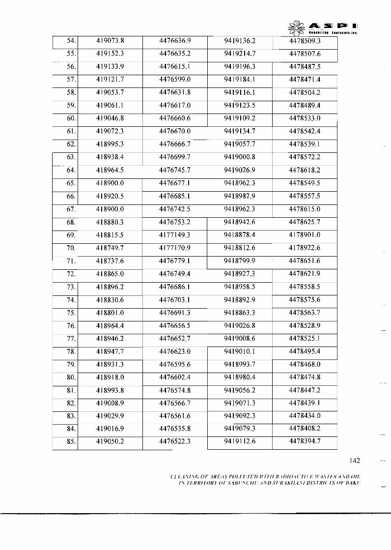
( [ I l \ l \ (rOl f R f I S i ' O I f l l f l > M l l f i h ' l i ~ f O 4 ~ I f 1 1 I t I S 1 1 S A \ l ) O i f 1 2 1 1 RKIIOKP O f S4RI \ ( I / ( 1 2 1 ) S l K l h l l 1 x 1 I)I,Slltl( 1.S 01 R/lh(
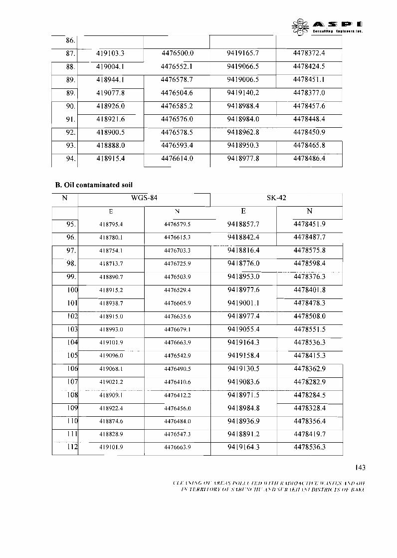
B. Oil contaminated soil
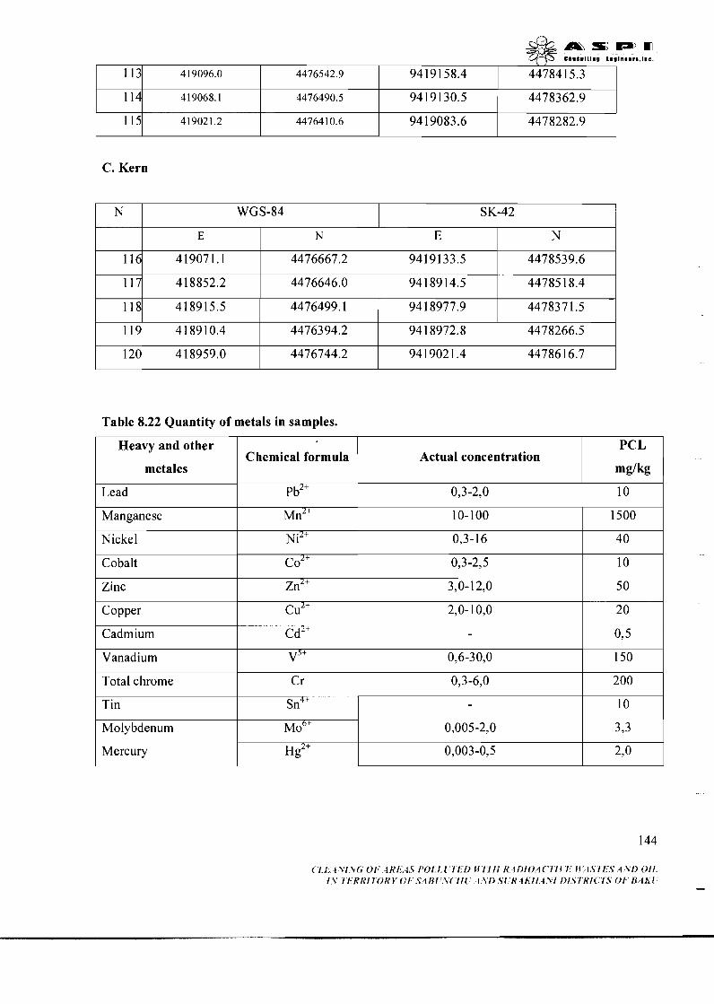
C. Kern
Table 8.22 Quantity of metals in samples.
Heavy and other
metales
Lead
Manganese
Nickel
Cobalt
Zinc
Copper
Cadmium
Vanadium
Total chrome
Tin
Molybdenum
Mercury
Actual concentration
0,3-2,0
10-100
0,3- 16
0,3-2,5
3,0-12,0
2,0-10,O
-
0,6-30,O
0,3-6,0
0,005-2,0
0,003-0,5
Chemical formula
pb2+
~ n ~ +
~ i ~ +
co2+
zn2+
cu2+
cd2+
v5+ C r
sn4'
M O ~ +
Hg2+
PCL
mg/kg
10
1500
4 0
10
50
20
0,5
150
200
10
3,3
2,o
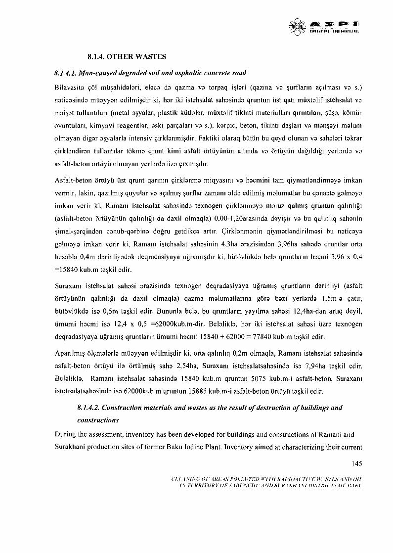
8.1.4. OTHER WASTES
8.1.4.1. Man-caused degraded soil and asphaltic concrete road
Bilavasita qol mugahidalari, elaca da qazma va torpaq iglari (qazma va gurflarln aqllmas~ va s.)
naticasinda muayyan edilmigdir ki, har iki istehsalat sahasinda qruntun ust qatl muxtalif istehsalat va
maigat tullantrlar~ (metal agyalar, plastik kiitlalar, muxtalif tikinti materiallar~ qlrlntllar~, guga, komur
ovuntulari, kimyavi reagentlar, aski parqalar~ va s.), karpic, beton, tikinti daglar~ va mangayi malum
olmayan digar agyalarla intensiv qirklanmigdir. Faktiki olaraq butun bu qeyd olunan va sahalari takrar
qirklandiran tullantllar tokma qrunt kimi asfalt ortuyunun altinda va ortuyun dagildlgl yerlarda va
asfalt-beton ortuyu olmayan yerlarda uza qixmlgd~r.
Asfalt-beton ortuyu ust qrunt qarlnin qirklanma miqyasln~ va hacmini tam qiymatlandirmaya imkan
vermir, lakin, qazilmig quyular va aqllrnlg gurflar zamanl alda edilmig malumatlar bu qanaata galmaya
imkan verir ki, Raman~ istehsalat sahasinda texnogen qirklanmaya maruz qalmq qruntun qalinlig~
(asfalt-beton ortuyiinun qallnllg~ da daxil olmaqla) 0,OO-1,20araslnda dayigir va bu qallnl~q sahanin
gimal-garqindan canub-qarbina dogru getdikca artir. Cirklanmanin qiymatlandirilmasi bu naticaya
galmaya imkan verir ki, Raman~ istehsalat sahasinin 4,3ha arazisindan 3,96ha sahada qruntlar orta
hesabla 0,4m darinliyadak deqradasiyaya ugramlgdir ki, butovlukda bela qruntlarin hacmi 3,96 x 0,4
=I5840 kub.m tagkil edir.
Suraxan~ istehsalat sahasi arazisinda texnogen deqradasiyaya ugramlg qruntlarln darinliyi (asfalt
ortuyunun qalinllg~ da daxil olmaqla) qazma malumatlarina gora bazi yerlarda 1,5m-a qatlr,
butovlukda isa 0,5m tagkil edir. Bununla bela, bu qruntlarln yayllma sahasi 12,4ha-dan art~q deyil,
umumi hacmi isa 12,4 x 0,5 =62000kub.m-dir. Belalikla, har iki istehsalat sahasi uzra texnogen
deqradasiyaya ugramlg qruntlarln umumi hacmi 15840 + 62000 = 77840 kub.m tagkil edir.
Aparllmlg olqmalarla muayyan edilmigdir ki, orta qallnl~q 0,2m olmaqla, Raman~ istehsalat sahasinda
asfalt-beton ortuyu ila ortulmug saha 2,54ha, Suraxan~ istehsalatsahasinda isa 7,94ha tagkil edir.
Belalikla, Raman~ istehsalat sahasinda 15840 kub.m qruntun 5075 kub.m-i asfalt-beton, Suraxan~
istehsalatsahasinda isa 62000kub.m qruntun 15885 kub.m-i asfalt-beton ortuyu tagkil edir.
8.1.4.2. Construction materials and wastes as the result of destruction of buildings and
constructions
During the assessment, inventory has been developed for buildings and constructions of Ramani and
Surakhani production sites of former Baku Iodine Plant. Inventory aimed at characterizing their current
V
condition and calculating the volumes of secondary materials to be produced when demolishing or
disassembling these constructions and removed from the rehabilitated sites to landfills.
18 objects of different purposes have been studies in Ramani, of which following 8 objects are
operational: administrative building - 1 object, barns - 5 objects, garage - 1 object, warehouses - 1
object. Other buildings are either dilapidated or destroyed. List of the types and volumes of secondary
materials, which will be produced and removed from Ramani site, is given in Table 8.23.
Studied were also 28 objects situated in Surakhani site (see fig. 8.2), of which following 7
constructions are operational: administrative buildings - 2 objects, power station - 1 object, gas
distribution station - 1 object, crystallization workshop - 1 object, civil defence point - 1 object,
transformer substation - 1 object. Other buildings are either dilapidated or destroyed. List of the types
and volumes of secondary materials, which will be produced and removed from Ramani site, is given
in Table 8.24.
Secondary construction materials in Ramani site 3836,68m3 and in Surakhani site 7673,4m3, total
115 10,08m3 construction waste will be produced. The total volume of secondary construction
materials to be produced from both sites is 4702,37 + 61 18,55 + 7673,4 + 3836,68 = 2233 1m3.
Picture 8.11. Other wastes in the territory.
Table 8.23. Construction waste volumes of Ramani site (m3)
Reinforced Different 1 Object 1 Limestone Bricks concrete 1 1 material 1 1
... . I I 1 I I
Object 102,68 I I I I
97,52
211,15 102,84
19,76 Object 1
1,38
49,36 28,4
4,85
-

1
I I
Object 13
Object 14
I Object 15
Object 3
Object 4
Object 5
Object 6
Object 7
Object 8
Object 9
Object 10
Object 11 I - Object 12
Object 16
Object 17
Object 18
1,8
48,O
-
-
57,6
34,56
167,94
100,84
25,Ol
1 TOTAL
Object 1
12,6 1
34,79
46,98
19 1,36
265,l
37,28
238,O
52,68
139,68
30,95
52,54
30,72
Object
, 3,6
8,9
70,56
27,84
54,72
74,6
309,42
565,54
2 18,82 ppppp
380,O
120,l
-
ppppp
96,6
Table 8.24. Construction waste volumes of Surakhani production site (m3)
1592,12
Reinforced
concrete
45,85
146,4 1
121,58
57 1,34
60,74
104,12
1 19,6
I
7 9 3
98,52
110,15
22,6 1
292,52
2283,7
Object 2
Object 3
Object 5 75,16
167,94
397,26
-
72,78
37,08 I
401,3
Object 4
Limestone 1 Bricks 1 Other waste 1 Total 1
1 ,o
425,25 1 4702,37 1
3 1,74
Object 8
Object 9
Object 10
Object 1 1
91,69
157,66
53,22
218,38
233,32
232,68
1,35

s&&...SElPE O f l cansuIt1nm ~nmtmeers .~ac .
Object 12
Object 13
Object 14 I I I I I
112,4
- 92,33
232,68
Object 15
Object 16
Object 17
Object 18
Object 19
Object 20
Object 2 1
Object 22
Object 23
Object 24
92,33
232,68
Object 25
Object 26
Object 27
8.2 CURRENT SITUATION OF POLLUTION AT THE SlTE OF CONSTRUCTION
OF DISPOSAL FACILITY AND IN AD,JOINING TERRITORIES
-
75,02
97,63
32,5
183,6
1 1,04
169,05
19,36
55,s
13,44
143,82
Object 28
Total:
At the site of construction of disposal facility and in adjoining territories (including the area of disposal
facility owned by Special Industrial Complex "lzotop") pollution of the environment was not detected.
1 12,4
21 1,98
9,5
32,4
9. DESCRIPTION OF THE WORKS TO BE UNDERTAKEN WITHIN THE PROJECT
-
10,5
49,92
45,6
140,O
64,5 1
569,6
35,78
3240,28
9.1 DISPLACEMENT PLAN
1048,7
40,32
The plan concept foresees the preparation of recommendations directed for mitigation of effects of the
108,O
-
-
-
1969,15
project on displaced people and provision normal living conditions after displacement. The main goal
-
of this displacement plan is preparation of arrangements of displacing internally displaced persons
-
-
7,92
1 1,O
79,O
865,2
settled in the former Surakhany Iodine Plant area and provision of new living conditions for them in 148
1 83,02
97,63
32,5
194,l
60,96
169,05
64,96
195,8
85,87
724,42
18,O
1 ,0
1278,68
10,5
72,72
43,92
1 14,78
6118,55
new settlements. In accordance with the World Bank requirments, new living conditions of internally
displaced persons should not be worse than their previous conditions. The displacement plan was
prepared on the base of the results of socio-economic investigation within Social Impact Assessment.
Both physical and juridical persons (enterprises, state bodies) may be subject to the project impact. In
accordance with the World Bank requirements, (OP 4.12) "persons subject to impact" are not
identified not by the official sanction or property rights given to live in the project area or to deal with
business. So, this notion shall attribute to every person subject to the project impact not depending on
the legal document availability.
All persons subject to the project impact are eligible to demand the repayment for the damage on them:
compensation for the property missed as a result of the project activity and restoration of living place
when being displaced to a new settlement.
While displacement, the following principles are necessary to undertake:
Living conditions of the displaced persons should not lower than before-project situation;
Living-communal and social infrastructure level should at least the same level with the previous
conditions;
Persons who have lost income source as a result of displacement should be ensured with relevant
work;
As a result of displacement, in case people lose property or end their entrepreneurship activity,
they should be compensated at the amount of the lost property or should be assisted to restore
private business;
Displacement should be maximum transparent for displaced persons;
In the course of establishment of displacement mechanisms, decision-making process should
include active participation of people to be displaced.
This document is a Draft Action Plan in order to realize the displacement. Final Displacement Plan, as
well as budget shall be approved in the last stage of the project implementations.

9.2 CONSTRUCTION WORKS
9.2.1 Construction of burial station of radioactive wastes
The range to be built for burial of low active wastes is scheduled to locate on 3 1st km of Baku-
Shamakhy highway, south-west corner of "Izotop" special centre fence in 700 m south from this
highway.
In the course of construction, the following works have been foreseen to undertake:
- Dig hole by mechanical way on the 3rd ground and dig out 372 thousand m3 ground;
- Level and compact the hole bottom;
- Construct reinforced concrete shelter with cast-in-situ reinforced concrete cover, shelter size -
~ O O O O O m3;
- Rehabilitate unfit lands, cover the shelter with the 3rd graded ground;
- Level and compact of the rehabilitated ground surface, earth works volume - 2 17,4 thousand m3;
- Constraction of the servise fasility - 100 m2;
- Constraction of the toilet;
- Reaovate the fasility area, earth works volume -35,14 thousand m2 and site electricity;
- Construct the fence of steel net by installing steel gate - 10 16m;
- Make 4 m wide road for 700 meter length from Baku-Shamakhy highway till the gate of range;
- Construct 1470 meter long and 1 m wide pavement - 4,27 thousand sq.m;
9.2.2 Construction of support wells in Ramany manufacturing site
In the course of the assessment works, it was determined that ground water in Ramany manufacturing
site locate on 0,3-0,4 m depth from ground surface. Besides, former lake connected with the
manufacturing site from the north-east directly influences on the ground water level.
Therefore, there is risk of water meadow from the lake in earth works for excavation of grounds in 2 m
depth ditches and holes. In order to eradicate this risk, it is foreseen to construct support wall to
separate the field from the lake. Works and volumes are described as follows:
- Digging dithes in 290 m length in the 3rd grade ground - 490m3;
- Reinforced concrete poling - 580,8m;
- Install reinforced-concrete support wall - 104,4m3;
- Hydro isolation of support wall - 769m2.
9.3 REHABlLITATlON WORKS
9.3.1 Dismantle buildings and structures, gather, delivery and assembly construction
wastes
Safe and demolished manufacturing buildings and structures in Ramana and Surakhany manufacturing
sites, and also construction materials and parts shall be dismantled till the foundation. The works shall
be undertaken by mechanisms mostly and by hands partly. In this process, the arisen repeat
construction materials and other wastes shall be loaded into the trucks by the excavators (if needed, by
the hoisting cranes) and shall be delivered to the assembly station determined in 25 km-s distance. In
general, the following repeat construction wastes are expected to arise:
- Foundations, walls, covers, frames, pillar and other reinforced-concrete constructions - 4832,4
thousand m3;
- Stones for building walls and fences - 4252,85m3;
- Construction bricks of the walls, partitions and other constructions - 1266,5m3;
- Other materials (asbestos-cement, wood and roll materials, steel constructions construction
garbages etc.) - 469,17 m3.
Total volume of repeat construction wastes the delivery of which is required from the plant's
manufacturing sites is described on the table 9.1.
Table 9.1. List and volume of repeat construction wastes
9.3.2 Gather, delivery and burial of radioactive wastes
In accordance with the conducted evaluation works, the volume of radioactive wastes to be buried on
the range for the radioactive wastes to be gathered, delivered from the manufacturing areas shall
comprise 85310 m3. Classification of these wastes per types are described on the table 9.2.
Table 9.2. List and volume of radioactive wastes (cub m)
Manufacturing fields
Ramana Surakhany TOTAL:
Other materials
425,25 43,92 467,70
Reinforced- concrete
constructions 1592,12 3240,28 4832,40
Manufacturing
fields
Construction garbage
3836,68 7673.4
11510,08
Total
8539,05 13791,95 2233 1 ,O
Construction stones
2283,7 1969,15 4252,85
Radioactive coal
Brick
40 1,3 865,2
1266,SO
Coal mixed
with brick
cracks 1 assemblies)
Coal mixed
with ground
(underground
Other solid Total
wastes
J
In addition to the mentioned wastes volumes, asbestos cement pipes of scale in inner walls with
diameter 0,l-0,5m should be delivered and buried. Total length of these pipes is 2000 m.
Ramana
Surakhany
TOTAL:
Gather of adioactive wastes and assembly in trucks shall be undertaken with backhoe capacity 0,5m3
doser ad excavators. Radioactive wastes shall be delivered to the burial unit in 50 kms distance from
12836
19092
3 1928
the manufacturing site with specially equipped trucks (dump truck). Radioactive wastes shall be
unloaded into the burial station levelled and compacted.
3770
15484
19254
The burial station shall be filled with sections. After filling each section, its upper surface shall be
lined with cover slabs and the upper surface of the slabs shall be compacted with isolating ground
2375
3 1707
34982
layer. Increase coefficient to the salary shall be applied as workers engineer-technical staffs work in
harmful work conditions in gather, delivery and burial of radioactive wastes.
12
3 4
46
9.3.3 Assembly, delivery and collection of oil waste and oil poluted grounds
18993
66317
85310
In accordance with the conducted assessment works, the volume of oil polluted wastes to be
assembled, delivered to the assigned places from the manufacturing sites, shall comprise 21 130 m3
Classification of these wastes per types is described on the table 9.3.
Table 9.3. List and volume of oil polluted wastes (cub m)
Manufacturing
spheres
Rarnana
Surakhany
TOTAL:
Mazut
2980
Mazut gathering and gather mazut from oil pools to cisterns shall be undertaken through trucks
carrying mazut equipped with special pumps. The assembled mazut shall be delivered to oil refinery
plants located on 25 km distance.
Gather of adioactive wastes and assembly in trucks shall be undertaken with backhoe capacity 0,5m3
doser ad excavators. Radioactive wastes shall be delivered to the burial unit in 50 kms distance from
the manufacturing site with specially equipped trucks (dump truck). The delivery shall be done
through special trucks from iodine plant to 25 kms distance to special locations. As the assembly units,
2980
Bitumen
10000
10000 14720
Bitumen oil
polluted
grounds
3420
1 1300
27700
Total
3420
24280
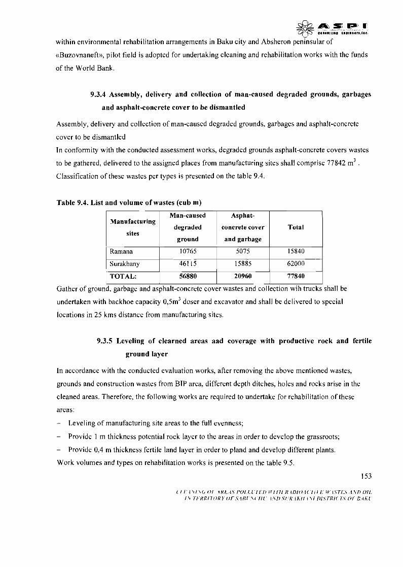
within environmental rehabilitation arrangements in Baku city and Absheron peninsular of
((Buzovnaneft)), pilot field is adopted for undertaking cleaning and rehabilitation works with the funds
of the World Bank.
9.3.4 Assembly, delivery and collection of man-caused degraded grounds, garbages
and asphalt-concrete cover to be dismantled
Assembly, delivery and collection of man-caused degraded grounds, garbages and asphalt-concrete
cover to be dismantled
In conformity with the conducted assessment works, degraded grounds asphalt-concrete covers wastes
to be gathered, delivered to the assigned places from manufacturing sites shall comprise 77842 m3 . Classification of these wastes per types is presented on the table 9.4.
Table 9.4. List and volume of wastes (cub m)
- sites 1 ground and garbage 1
Manufacturing
1 Ramana 1 10765 1 5075 1 15840 1 I
Surakhany 461 15 15885 62000 1
Man-caused
degraded
I I I TOTAL: 56880 20960 77840 1
I , I
Gather of ground, garbage and asphalt-concrete cover wastes and collection wih trucks shall be
Asphat-
concrete cover
undertaken with backhoe capacity 0,5m3 doser and excavator and shall be delivered to special
Total
locations in 25 kms distance from manufacturing sites.
9.3.5 Leveling of clearned areas aad coverage with productive rock and fertile
ground layer
In accordance with the conducted evaluation works, after removing the above mentioned wastes,
grounds and construction wastes from BIP area, different depth ditches, holes and rocks arise in the
cleaned areas. Therefore, the following works are required to undertake for rehabilitation of these
areas:
- Leveling of manufacturing site areas to the full evenness;
- Provide 1 m thickness potential rock layer to the areas in order to develop the grassroots;
- Provide 0,4 m thickness fertile land layer in order to pland and develop different plants.
Work volumes and types on rehabilitation works is presented on the table 9.5.
153
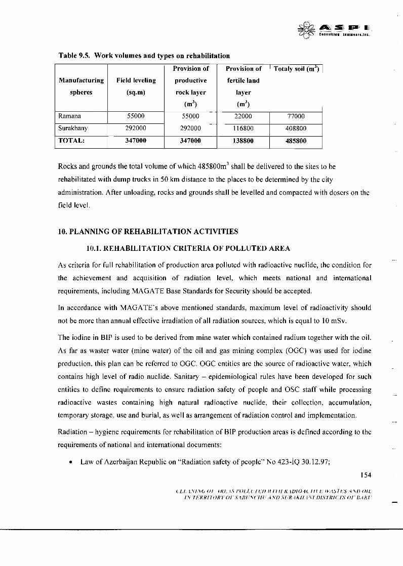
Table 9.5. Work volumes and types on rehabilitation
Rocks and grounds the total volume of which 485800m3 shall be delivered to the sites to be
rehabilitated with dump trucks in 50 km distance to the places to be determined by the city
administration. After unloading, rocks and grounds shall be levelled and compacted with dosers on the
field level.
Manufacturing
spheres
Ramana
Surakhany
TOTAL:
10. PLANNING OF REHABILITATION ACTIVITIES
10.1. REHABILITATION CRITERIA OF POLLIJTED AREA
Field leveling
(sq-m)
55000
292000
347000
As criteria for full rehabilitation of production area polluted with radioactive nuclide, the condition for
the achievement and acquisition of radiation level, which meets national and international
requirements, including MAGATE Base Standards for Security should be accepted.
In accordance with MAGATE7s above mentioned standards, maximum level of radioactivity should
not be more than annual effective irradiation of all radiation sources, which is equal to 10 mSv.
Provision of
productive
rock layer
(m3)
55000
292000
347000
The iodine in BIP is used to be derived from mine water which contained radium together with the oil.
As far as waster water (mine water) of the oil and gas mining complex (OGC) was used for iodine
production, this plan can be referred to OGC. OGC entities are the source of radioactive water, which
contains high level of radio nuclide. Sanitary - epidemiological rules have been developed for such
entities to define requirements to ensure radiation safety of people and OSC staff while processing
radioactive wastes containing high natural radioactive nuclide, their collection, accumulation,
temporary storage, use and burial, as well as arrangement of radiation control and implementation.
Radiation - hygiene requirements for rehabilitation of BIP production areas is defined according to the
requirements of national and international documents:
Provision of
fertile land
layer
(m3)
22000
1 16800
138800
Law of Azerbaijan Republic on "Radiation safety of people" No 423-IQ 30.12.97;
154
Totaly soil (m3)
77000
408800
485800
- ((Radiation safety norms (NRB-76/87))) Ne 392-87 26.05.87;
Sanitary - epidemiological rules and norms SanPiN 2.6.6.1 169-02 ((Radioactive waste.
Provision of radiation safety during processing of production waste containing high natural
radioactive nuclide in oil and gas complex of Russian Federation )) 16.10.02;
((Main international safety norms for secure activities of ray sources and protection from
ionium laser sources)) MAGATE's edition for safety No 11 5, Vienna 1997.
Sanitary - epidemiological rules and norms define the followings: (SanPiN 2.6.6.1169-02)
Classification of production waste in accordance to their effective activity of natural
radioactive nuclide;
Criteria to ensure radiation safety of the people and OGC staff during their processing of
production waste, including their collection, temporary storage, transportation, refinery and
burial;
Radiation - hygiene and limitation system while working with production waste;
Radiation safety supervision, as well as requirement for radiation safety control while
processing production waste;
List of control parameters of production waste to be used in the future, criteria and norm
system;
Radiation - hygiene requirement for rehabilitation of OGC entity area when, their activities are
terminated;
Requirement for radiation - hygiene passport of OGC entities while processing of production
waste containing high level of natural radioactive nuclide.
In accordance with this document, the main criteria for normalization of the radiation condition of the
areas are as follows:
Absence of the area with more that 0.2 mkZv/hour gamma radiation equivalent in 1 m deep
from the earth surface;
Absence of the area with more than 370 Bktkg provisional indication of natural radioactive
nuclide effective activity in top soil and soil structures;
quantity of radioactive nuclide in the open watershed waters should not be more than twice of
provisional indication;
155
$ & m S E L P ' O , C j - ~ 5 e n n t u l t l n n t ~ n ~ n o n r t . ~ n c .
after rehabilitation of the area the effective doze of additional radiation for the critical group of
people living in this area should nor go beyond 1 OOmkZv/year;
initial radiation - hygiene features of the areas were derived from the analyses of the areas of
similar geological - geophysical features. Effective activity of natural radio nuclide values of
the topsoil samples obtained beyond the coverage area of production area of the plants vary
between 80-120 Wkg. Effective doze of gamma radiation of the measured in 1 m depth from
the earth surface beyond the coverage area of production area of the plant is characterized as
0.07 nkZv/hour.
So, following criteria shall be accepted for normalization of the radiation conditions of the production
area of the plant:
Absence of the area not more than 0.27 mkZv/hour effective doze gamma radiation equivalent
in 1 m depth from the earth surface;
Absence of the area not more than 470 Bklkg effective activity of radioactive nuclide in top
soil and soil structures;;
After rehabilitation of the area, the effective doze of additional radiation from the natural
sources on the critical group of people should not go beyond 100 mkZv/year.
10.2. REHABILITATION ALTERNATIVES OF THE POLLUTED AREA
There are three real variants in the world practice for environmental rehabilitation of the area polluted
with various waste. These include:
Full rehabilitation of the lands for future use wothout rehabilitation;
Rehabilitation of the lands to the limit with special permission and control system for separtae
land users;
Conservation of the polluted area with prohibition to approach;
The rehabilitation alternative of the polluted area of BIP is defined with proximity of the production
area to residential sector. Surakhani area is located in 200 m to the west of New Surakhani settlement.
Ramani area is directly bordered with individual housholds.
With regards to demographic growth, as well as the implementation of short and long term plans and
programs for social - economic development and reconstruction of Absheron peninsular, Baku and
suburban area by Azerbaijan Government and Baku administration, both of production area of BIP
& & m e m o 3@ C~IIIUIIIII~ i l g l ~ m m r s . ~ ~ ~
Id be transferred to the land fund of local municipality for the development of their infrastructure
and housing. That is why the objective of the project is to achieve the maximum possible rehabilitation
of the liquidated and polluted lands. At this time human access to this areas iiill prohibited and
conservation of polluted materials in production areas are excluded.
As it was expected, the analyses of pollutions in production area showed that the environmental
condition in both areas is the same. The features of the polluters, including radioactive wastes, the
types of wastes, as well as pollution rate are almost the same. However, hydrological and hydro
geological condition beyond the coverage area is different.
As it was mentioned above, pond of oil mining waters which was used for iodium production befor is
located next to the Ramani production area. Analyses manifest that, there is radiactive coal layer along
the borderline attaching the ppond to the area. Initially as radium compositions exisiting in the layer
waters deposited, the pond bed was polluted with radioactive nuclide at some distance from its coast.
Mine water containing radium compositions is still discharged into the pond at the moment since the
oil drilling on the other coast continues so far. As the bed depositions of the pond is polutted with
radioactive nuclide, reasonable earthworks is required to prevent from mine water discharge, drying of
the pond and collection and transportation of bed depositions when full rehabilitation of Ramani
production area is applied. Moreover, the water in the pond completely screens the radioactive
radiation making radiation from the water surface equal to 8-12 mkrlhour and this is more than average
indication of 9 mkrlhour for Baku city.
Other obstacle for full environmental rehabilitation of Ramani production area id the high level of
ground water (30-40 sm from soil surface) due to the water in the pond. The analyses showed that
there I and I1 category radioactive waste in groud water effected zones, i.e. 1.2 m deep from soil
surface. This will hinder from full liquidation of polluters during earth works, because ground water
this will cause mixture of clear and pilluted subsurface horizons during excavation and residue of I
category pollutions in light depth.
So, the possible rehabilitation alternative in Ramani production area is partial rehablitation through
screening the I category residue pollution with soil at required thickness to prevent the root of the
plants fron reaching the polluted soil in consideration of restriction to use surface and ground water.
The radium in the latter ones is observed in the form of insolubale composition, its spreading over the
soil is not possible. Thus, the requirements of SanP and N2.6.1169-02 will be met.
Engineering geologcal and gydrogeological condition of Surakhani production area doesn't prevent
from implementation of rehabilitation activities in that area. However, althought the grounwater is
157
w observed in considerable depth (140-290 sm from soil surface) I and J J category radioactive wastes
were found in different locations 130-200 sm from soil surface and in some locations even 300-450 m
from soil surface. One of the possible variants during excavation activities without inundation hazard
is pumping the water collected in excavated wells, or preventing the water from filling these wells.
Such enginnering solutuion of the problem will enable excavation of radioactive waste from aby depth
of Surakhani production area. After All radioactive substances (radioactive waste, oil and oil products
and technical waste) are liquidated and the area is covered with safe soil, it will be possible to recycle
it for farming without any limitations for future use.
Thus, rehabilitation alternatives of polluted area are accepted as follows:
Full rehabilitation of the Surakhani production area for unlimited use; and
Partial rehabilitation of Ramani production area with limted use on surface and ground water.
10.3. REHABILITATION METHOD OF POLLUTED AREA. TECHNICAL AND
ENGlNEERlNG FEASlBlLlTY
10.3.1. General information
Following type of polluters were defined within activities for evaluation of actual condition of the
area:
Used coal, mixture of the used coal with construction material residue (break, gravel, plaster,
etc); mixture of used coal with the soil, silt and chemical sediments deposited in asbestos pipes
of sewerage network
Soil and groud waters polluted with black oil and oil products;
Residues of productin structures and construction materials;
Technically degradated top soil and destroyed asphalt and concrete liling;
Selected rehabilitation alternatives directed to sanitary - hygene recultivation of polluted area . --
will enable to reduce specified impacts to a possible minimum level along with rehabilitation
these areas and recycling it to farming.
Rehabilitation variants directed towards sanitary-hygyenic recultivation of polluted areas will
enable full or maximall mitigation of results of pollution besides rehabilitation of economical
environment of territories.

Technical solution of the problem will consist of three components:
Neutralization of radio active and oil waste;
Purificatino of the plant area from construction materials, garbige and technically degradad
soil;
Plannin og the cleaned surface, provision of potentially productive soil and fertile soil surface;
Safety precautiones and qulified implementation of the works in the sites during planned
activitied for the rehabilitation of the polluted area, provition of environmental monitorinq, as
well as safety assurance on the highway while transportation of the waste to the collection and
utilization sites.
During implementation of measures for rehabilitation of given territories security measures, qualitative
realization, ecological monitoring, also safety in road during transportation of wests will be provided.
10.3.2. Neutralization of radioactive waste
4 potential alternatives can be reviewed for neutralization of radioactive waste of the Baku Iodine
Plant:
A) Burning; B) Hiding under earth fill; C) discard to the unused oil wells; D) burial at polygons.
A) Burning - this the simplest utilization way of the radioactive waste and can be done in existing
coverage area or in a special polygon allocated out of the plant area. However, this approach may
bring negative results as spreading radioactive nuclides Ra-226, Ra-228 in the air, emerging of ash
residues with special effective activity more that initial value and these may cause reiterated pollution
of rehabilitated areas, as well as total environment with ash residues spreading around mixed with
atmosphere agents (wind, rain, etc). Moreover, it is not possible to achieve complete burning of the
radioactive waste mixed with construction material residue, garbage and soil. All these contradict to
the selected rehabilitation and cannot be accepted as neutralization method of radioactive waste of
BIP.
B) Hiding under earth fill - may be another potential neutralization method of the waste. This
method is based on the principle of covering the radioactive coal and soil surface to be excavated with
water resistant clay soil to minimize the risk of water discharge to the waste, possible radon gas an
emission and the probability of spreading of the waste with the wind. On the other hand, in order to
limit the human approach to these hills, they should be additionally covered with concrete lining. Since
the content of the waste is not homogeneous, radioactive pollution is not evenly spread in the areas and
l i
topographic condition in not in accordance with the standards, the utilization method of the waste
described in this para is excluded. In view of the above mentioned the utilization of waste with earth
filling is a problematic in terms of engineering calculation and provision of radiation safety.
C) Discard of the waste to the unused oil well - As far as this method is not practical method; it is
more adequate for utilization of the small polluted materials of which the radiation level is relevantly
high. In view of the high capacity of the light radioactive wastes in the Project sites this alternative is
deemed optimal as per economic and technical reasons. Moreover, in order to realize this alternation
careful selection of unused wells and their detail scrutiny are required for reliable storage of the waste
located in areas. Respectfully, storage of the radioactive waste in unused oil wells can not be reviewed
as an optimal utilization method.
D) Burial in shallow polygon: in view of the radioactive force of light radiation waste under this
project and its high capacity Burial of the waste in special designed and constructed shallow polygon is
deemed as an appropriate alternative for utilization of the waste. Moreover, this method is the most
practicable method of similar waste utilization and highly supported by MAGATE and its members.
Such neutralization method meets the requirement of partial and complete rehabilitation alternatives
and is accepted as radioactive pollution method in rehabilitation areas.
Special station will be built in the area next to the "Izotop" special enterprise area. Transportation
distance of the radioactive waste is 50 km and transportation will be made with special vehicle
supplied for this purposes.
Excavation of radioactive waste from the production area of the plant will be done with technical
means in accordance with respective norms and rules.
10.3.3. Neutralization of oil waste
4 alternatives can be reviewed regarding oil waste (black oil, bitumen, polluted soil with oil - organic
composition): A) Burning; B) Hiding under earth fill; C) discard to the unused oil wells; D)
transportation of the oil waste to the special collection polygon beyond the area and its utilization.
A) Burning - burning of the oil waste in the current area can partially solve this problem, because
only black oil and bitumen can be burned, excluding oil products collected in the reservoirs in the
areas and oil-polluted lands. Moreover, Ra - 226 and Ra - 228 radioactive nuclide in the burned
products will diffuse in the air, which will negatively impact to the environment and local population
health. All these contradict selected rehabilitation alternatives and can not be accepted as neutralization
method of oil waste.
160
B) Hiding under earth fill - Similar to the reason reviewed under neutralization of the radioactive
waste, it doesn't meet the requirement of partial or full rehabilitation of the production area of the
iodine plant.
C) Discard to the unused oil wells - Since the capacity of the waste to be buried is high and absence
of necessary reserves of unused oil wells, this alternative also cannot be considered as optimal
alternative for the utilization of oil waste.
D) Transportation of oil waste apart from the areas - this the most adequate alternative for
neutralization of the wastes under review, because this alternative completely meets the requirement of
complete and partial rehabilitation alternatives. Liquid oil wastes will be collected to the mobile tanks
and will be delivered to the oil refinery enterprise for utilization. Bitumen and oil polluted soil will be
transported to the oil waste polygon at 20 km from the area with loader. Earth works will be done
technically and in accordance with Construction Norms and Rules.
10.3.4. Cleaning the production area from reiterated construction materials, garbage
and technically degraded structure
Reiterated construction materials in production area include:
Concrete and iron products and structures, cubic stones, brick pieces and various construction
fundaments;
Remaining concrete and iron substances of reinforced concrete shell and structures, separate
reinforced concrete blocks and columns;
Concrete, metal and wood structures of the destroyed buildings, cubic stones, bricks, sewerage
equipment and other materials;
Construction and sanitary materials and products of surface and subsurface infrastructure;
Various construction garbage spread in production area of the destroyed buildings;
Asphalt and concrete lining arena.
Layer, the depth of which vary between 0.2-1.5 m polluted with the construction, production and home
waste was discovered under asphalt-concrete lining, during evaluation works by means of digging
geological holes and test pit.
According to the requirements set forth for the rehabilitation areas, absolute destruction of all
buildings and structures, including asphalt-concrete lining and technically degraded top soil polluted
with various waste and located under asphalt and concrete lining, and transporta%on of other technical
and home waste from the area is under consideration.
The analyses show that all this mass has not undergone radioactive pollution and that is why it is
considered to excavate them with earth digging machinery and to transport them with dumper to the
special polygon or common garbage station for utilization or burial.
Destruction of buildings and structures in plant area and cleaning of the area from various materials,
garbage and polluted soil will be done technically and in accordance with the construction norms and
rules.
In consideration of ground water in Ramani production area to be near the surface, special activities
will be implemented to reduce water level during excavation of the soil and destruction of the building
and structure foundations.
10.3.5 Leveling of cleaned areas and provision of potentially productive and fertile top
soil.
As a result of earth works to be made with regards to radioactive and oil polluted soil, reiterated
construction materials, various garbage and technically degraded soil, there will emerge many pits,
holes, and ditches of different depth in the production area and following activities will be
implemented for the recultivation:
1 . Leveling of the cleaned area topography without closed depth and side slope. The formulation
of the project topography will be carried out in consideration of topography of the nearest area. At this
time, in order to prevent from the possible erosion process the gradient of the rehabilitation area will
be accepted at 3'. Ramani area which collects water to its slope in reasonable capacity will be
protected with special canal and its berm of rain, snowmelt, and downpour will be strengthened with
stone.
2. Provision of potential productive soil structure and fertile top soil by technical means for the
development of various tree and bush root system. The productive top soil will be transported with
dumpers to the rehabilitation area and the soil excavated from the foundation during the construction
of apartments, industrial structures and other infrastructures in Baku city will be used as productive top
soil upon approval of relevant authority. The average thickness of the productive top soil will not be
more that 1 m. The application of the fertile soil will be first piled up with special developed network
and then will be spread out by bulldozer.
0 1Wsm,m $& . > .." ..... .. I....,... .
3. Technical application of the fertile soil to the recultivation areas for development of trees and
bushes. Fertile soil will be brought with dumpers from the construction sites and areas determined by
the City Executive Authority. All recultivation activities will be carried out in accordance with
Construction Norms and Rules in force.
10.4. EXISTING ORGANIZATIONAL AND HUMAN RESOURSES
Planned works and relevant activities for rehabilitation of polluted area will ensure necessary
organizational and human resources.
1. The construction of the relatively light radioactive waste will be done by the contractor's,
which will be adequately experiences and selected under bidding in accordance with World
Banks procedures and conditions, as well as national legislation and standards.
2. The liquidation of the pollutes from production area of the Iodine plant and recultivation
activities will be done by the contractor who will be adequately experiences and selected
under bidding in accordance with World Banks procedures and conditions, as well as
national legislation and standards. Engineers and working staff who be involved in these
activities will be trained the rules how to work in the areas polluted with the radioactive
waste, to accompany the waste to the final destination for burial and to bury the radioactive
waste.
3. Safety measures during the cleaning of the areas from polluters and recultivation activities
will ensured by the staff of the contractor and the police of Ramani and New Surakhani.
4. Construction quality and safety during construction of the polygon to bury radioactive
waste, as well as earthwork and recultivation activities will be ensured by the Fire Control
Agency, State Sanitary Service of MoH, Commision of Work Condition under Ministry of
Labor and Sosial Protection and Agency for construction works safety of the MES, as well
as by Safety force of industry and mining of MES.
5 . Any reaction to possible emergent situations, which may cause by spontaneous radioactive
nuclide pollution during recultivation activities, transportation of the radioactive waste,
traffic accidents, as well as unloading and burial of the waste in the polygon will be ensured
by the respective divisions of the "Izotpop" and the Civil Defense force of the MES.
6. Traffic safety during transportation of the reiterated construction materials, various garbage
and radioactive polluted soil will be ensured by the force and facilities of the State Traffic
Police Department of the MIA.
163
d20 A s P 3 5 c."."llln@ [email protected],.l.c.
7. Environmental monitoring in the process of rehabilitation will be carried out by "Izotop"
special enterprise of MES, Environmental Monitoring Department of MENR, as well as by
an independent firm (research institute, NGO specialized in environment, consulting
company, etc) selected under bidding
10.5. EXISTING FINANCIAL RESOllRCES AND CONSTRAINTS
Government has practically completed its reserves in current social-economic reforms and commenced
reconstruction of existing infrastructure, which requires needs urgent renovation and establishment
modern art infrastructure. Independent experts pay significant attention to the environmental projects
within reconstruction of infrastructure and environmental rehabilitation in Absheron peninsular among
urgent project, which are estimated in the amount of 100 billion US Dollars. Moreover, in
consideration of constraints in financial resources the Government uses the proceeds of the budget and
State Oil Fund to the social - economic development projects, such as improvement of road network,
reconstruction and strengthening of power generation structures and modification of existing
infrastructure. That is why, The Government currently prefers to receive concessional loan from
foreign financial institution, including World Bank and to involve it is own institutional and technical
resources for the implementation of the urgent environmental project s, as well as this one.
The Government has allocated financial and logistic resources under this project for preparation
activities (evaluation of the current status, preparation of the feasibility study, EIA and social impact
assessment).
For realization of the main phase of the project the involvement of the financial and logistic resources
will done on the "most effective" principle and therefore the optimization of the resource use was
brought to the front providing justifications to the priority and preventative feature of the project
safety.
World Bank resources will be directed to provide following activities:
a Rehabilitation works and preparation of detail design of the polygon to be constructed for
burial of radioactive waste;
Construction of polygon for relatively light radioactive waste;
Construction of abutment in Ramani production site;
( i f , l\l\(r O f IKI I \ 1'01 1 I I t I ) ~ ~ I I I l R lI)I04C f l f 1 11 I<fi,.Y 4 ' r i ) Oil , I I f I f f 0 0 . 1 I I \I>SI K l h i l 1x1 l ) I S i R i ( I S 0 1 i l / l h i -
'-2'
Destruction of existing, deteriorated and partially destroyed buildings, structures and
equipment in production area of the BIP, transportation of reiterated construction materials and
different waste to the specially allocated collection/util ization filed;
Collection of radioactive and oil waste, as well as oil polluted soil from the production area of
the BIP and transportation to collection/utilization places;
Collection of construction, production, asphalt concrete linings, as well as technical degraded
soil and transportation to the collection/utilization places.
Leveling of the cleaned areas, application of potential soil structure and fertile top soil;
Procurement of the special equipment and technical facilities which is not at the disposal of the
of the contractor, for the implementation of the engineering geological and technical works;
Provision of independent environmental monitoring during rehabilitation activities;
Arrangement on conduction of the training for the personnel involved to the collection,
transportation and burial of the radioactive waste;
Project management and its control.
Government resources will be directed to ensure following activities:
Safety of the rehabilitation area will be ensured by the force and facilities of the district police
office of the MIA;
Qualified and safe implementation of the construction and rehabilitation activities will be
ensured by the respective agents of the MES;
Emergent situation preparedness and timely reaction will be ensured by the civil defense
divisions of the MES;
Traffic safety will be ensured by the State Traffic Police Department of the MIA;
Environmental monitoring during rehabilitation activities will be ensured by respective
divisions of MES and MENR;
ICb m z , m r , 5% ~ # ~ 8 l l I t l l l # ~ ~ @ l l l D D ~ ~ . l l l C
11. EVALUATION OF THE ENVIRONMENTAL IMPACT OF PROJECT OUTPUTS
11.1. BACKGROUND
Positive environmental impacts of construction of polygon for light radioactive waste and
rehabilitation activities in BIP production area are well known and this issue needs careful scrutiny.
Main objective of the evaluation is to define negative impacts, which require special mitigation
measures to minimize the results of such impacts. Table 11.1 manifest positive environmental impacts
of the activities under the project and Table 10.2 manifest possible negative impacts and respective
mitigation measures of similar projects of the world practice.
1 refugees I human life products I
Table 11.1. Positive impacts of project realization
Type of the activities
Resettlement of internally displaced people and
neutralization of the radioactive waste of iodine
Construction of support wall Prevention of the surface water leakage,
Expected impacts
Prevention of environmental pollution with
I
Construction of polygon for radioactive waste
1 transportation of reiterated construction materials 1 sources with the production waste and l
Establishment of the condition for full
Destruction of building and structures, collection,
improvement of hydro geological condition
Liquidation of reiterated environmental pollution
and garbage
Collection, transportation and burial of
1 polluted soil 1 living area and environmentally sensitive zone I
construction waste
Liquidation of environmental hazards to the
radioactive waste
Collection and transportation of oil waste and oil
human health and radioactive pollution source
Liquidation of environmental pollution source in
Collection and transportation of technically
polluted soil and various garbage
Leveling of cleaned area, provision of potentially
productive soil and fertile top soil
Liquidation of reiterated pollution source of the
land and soil
Establishment of natural condition for the
development and habitation of the flora and fauna
Table 11.2. Possible negative impact of the Project and mitigation measures
Possible mitigation measures of the impact
Defensive measures. Joining of work zone,
Type of the activity
Civil works (damaging
Possible impacts
Damage to the locally

2f the natural
:ondition in work
area)
Storage of fuel -
lubricants,
zonstruction
equipment and refuel
of the equipment
Construction
equipment and
operation of the
vehicles
Collection and discard
of production waste
Transportation of
production waste
Burial of radioactive
waste
Waste emerging from
rehabilitation process
sensitive area (destruction
of the top soil, increased
erosion processes)
Reiterated pollution of the
land as a result leakage and
spill of the oil products to
the ground water
Smock
Noise
Dust
Reiterated pollution of the
cleaned area.
Dusting into the air.
Dusting into the air.
Reiterated pollution of area
along the trace with liquid
and solid waste
Pollution of the polygon
with the solid waste
Pollution of the soil and
water with production and
domestic waste
zareful rehabilitation of the soil and habitation
environment
Designing of the embankment around gas
filling station and storage station with water
resistant isolation, immediate reaction means
(absorbents, special fencing, etc.)
Training of the personnel, preparation and
conduction of training for action plans during
incidents. Regular control of the safety
techniques.
Provision of reliable service, following
operation norms and standards.
Supply of the equipment with respective filters.
Avoid unnecessary operation of the engine.
Speed limitation of the vehicles.
Avoidance of overloading beyond the norms.
Liquidation of reiterated pollution.
Damping of the potential dust sources.
Provision of air tightness of transported waste.
Reaction during incident.
Defensive measures.
Liquidation of the pollution.
Effective collection of the water and its
management
dJ0 A m s IP7 0 , 7 8 .."..,I.. 1 .,La..., I..
11.2. ENVIRONMENTAL IMPACT OF THE REAHRILITATED AND PROXIMArI'E
AREAS
11.2.1. Construction period
Construction activities suggested in feasibility study will enable to solve the seepage of the surface
water from raw lake and subsurface water to the area during pollution control and respective earth
works in Ramani production area.
11.2.1. I. Positive impacts
Inundation and wash-out hazard of the working site due to the raw lake water during earth works
initially predicts the requirement for support column among the raw lake. Supporting columns will
enable to abolish this hazard and provide stability preventing the top soil applied during recultivation
from wash-out due to lake and sliding. Supporting column based on the piles will have a positive
impact to the ground water regime in the future mitigating direct hydrological and polluting impacts
due to the raw lake. This will also have a positive impact to reduce pollution of the ground water with
chemical content and organic oil composition.
11.2.1.2. Negative impacts and mitigation measures
Negative impacts of the construction activities are related with technical works and production and
domestic waste appeared during construction process. In this case no negative impact is expected to
the soil cover, fauna and flora with regard to the activities done in Ramani production area.
A. Technical works.
Operation of construction equipment and vehicle will be accompanied with air pollution,
environmental pollution and noise.
Air pollution.
All vehicle, equipment and machinery will be operated with diesel and it will be possible to avoid
smock and soot pollution beyond the norm with proper operation and necessary maintenance. Air
pollution will be also created during preparation period, filling of the dike, piling, welding, and
transportation of the concrete and concreting. Air pollution will be represented with evaporative
carbon hydrogen CO, NO2, SO2, C02, and particulate matter. The final waste for each polluters will
temporary and less important due to the small capacity. Auto gas will rapidly spread in the air and will
have no considerable impact to the people, domestic animal and cropping patterns near to Ramani
production area. In order to avoid pollution beyond the norms timely maintenance of the vehicle and --
overloading of the construction equipment beyond its capacity.
&&.rns la) 0 , q-p c.nsul~,", t.,l...r.,l.E.
In view that the earth is far from the construction area, as well as asphalt - concrete lining of the
production area and operation road, considerable pollution of the air due to the movement of the
vehicle and construction equipment is not expected.
Noise
Noise due to the construction of the support column will be in the rate of 70 dBA at 50 m, 63 dBA at
100 m, 55 dBA 200 m. Practical recommendations are provided in British Standards BS 5228 "Noise
control during construction and open area" (BSI, 1990) to minimize noise during construction. It is
expected that in 200 m from the operation area (in the location of living house) the noise impact will
be low.
The speed of the vehicle will be limited to mitigate air pollution and noise.
B. Maintenance of SYM and vehicle gas filling
Temporary station will be maintained to store SYM and gas filling to the vehicles to en sure
continuous operation of the construction equipment during construction works. The main reason of
environmental damage will be violation of relevant requirement for safety techniques and fire safety
during construction activities and maintenance condition of the SYM and its proper operation. This
will be visible in technical service of mobile equipment (pump, generator, compressors, etc.) and big
construction equipment (excavators, bulldozers, concrete mixers, etc.) in open conditions.
Nevertheless of intensive pollution of the production area and raw lake with oil and oil product waste,
leakage from the SYM still remains as technical environmental impact factor. Especially, burn of
quick-burning oil product may cause of fire hazard spreading to the individual housing.
This hazard may be avoided with adequate planning and management of the civil works contractor.
Technically equipped stock and gas filling station of the SYM will be arranged in special area
equipped with embankment to avoid spreading of the SYM during incidents and at 50 m apart from
any oil polluted area. Maintenance of the SYM and gas filling station should be equipped with oil
product cleaning instruments (absorption paper, etc), as well as fire safety facilities (fire extinguisher,
spade, hack, crow-bar and and to extinguish the fire).
One of the most important activities to avoid potential leakage, slicks and fire hazard is to train
personnel involved to the construction works through regular explanations on preparedness plans and
activities, as well as provision of inspections by contractor management, project management and
respective inspectors of MES.
Training
& o m s a w , -@ C O ~ 8 l i l t l N ~ O ~ l ~ @ ~ ? S , l * ~ .
will develop production attitude of the personnel, adjust to the adequate standards and each of
the staff:
Firstly, understands the existence of the hazardous problem and what is likely to happen;
Secondly, is aware of the responsibility to avoid leakage, slick and fire, is trained to take
adequate measures and has necessary equipment and support.
In case of incidental leakage, destruction and fire hazard, personnel should act in accordance to the ES
reaction plan described in feasibility study.
C. Production and domestic waste.
During construction process various waste will occur, which will need further utilization. These
include:
Inert construction materials (reinforced parts, welding electrode, wooden containers, tanks,
wooden and iron framework pieces, other construction waste);
Office, food and domestic waste; waste water;
Used lubricants and dirt, light lubricants and fuel tanks;
Various individual utility wastes (furniture parts, defense glasses and helmet, torn dresses and
shoes).
All solid harmless waste will be utilized according to the local rules and will be transported to the
specified place together with the waste of the iodine plant. Residues of the SYM will be utilized
together with oil waste of the plant. Harmful waste (accumulator batteries, SYM plastic tanks) will be
stored for refinery or destruction. Waste water will be collected in the special wells or to the raw pond
and be discharged to the Hovsan canal. Capacity of domestic waste and wastewater will be little and
have no significant impact if necessarily managed.
D. Transpiration of loads.
During construction period transportation of huge capacity of construction materials (cement, sand,
gravel, concrete, reinforcement, wood, etc.) and other secondary materials with big trucks will be
required. Materials will be transported with Baku - Mardakan highway and its connecting roads at
intensive movement. Moreover, there is nor chance to use secondary roads, except access roads to the
production area (which is not more than 0.5 km). That is why the client should reach mutual agreement
with the contractor regarding safe drive of trucks (together with State Traffic Police), as well as to
L'
minimize inevitable temporary impacts (smock, noise, vibration, dust, mud, traffic jam, etc.) to other
traffic user and local population, as possible.
11.2.2. Rehabilitation period
Rehabilitation works will enable abolishment of pollution source with recultivation and update
bioproductivity of the production area of BIP.
11.2.2.1. Positive impacts
Rehabilitation of the production area of BIP will cause following positive impacts:
Complete abolishment of the radioactive pollution of the land and soil with provision of
background values of the ionizing emission on the earth surface;
complete abolishment of land and soil with oil and oil products ensuring the organic
composition of the oil in soil below the YVQH level;
complete rehabilitation of the area polluted with technically degraded soil and construction
materials;
Complete rehabilitation of the polluted area with provision of bioproductivitiy of the top soil
and natural condition for the development of flora and fauna and their inhabitance;
Complete abolishment of danger to human health emerging from the technical pollution of the
production areas;
Improvement of earth architectural landscape providing potential land for the civil works.
11.2.2.2. Negative impacts
Negative impact from rehabilitation activities within the limits of production area may also be cause
by occurrence of production and domestic waste from mechanical works and contractor activities.
Moreover, huge polluted soil and technical masses, as well as during their transportation FH may have
negative impact.
There will be no negative impact to the top soil and type of flora and fauna in both production filed, as
well as in specified collection fields and this is because of their absence (exclusive of dispatched areas
where weeds grow).
A. Technical works
Liquidation of pollution under the project and recultivation activities in production area require
involvement many construction and excavation equipment (not less than 10 units), as well as heavy
17 1
&&msam 0 6 e D " t U I I I " # t l l l l . . l . . l l C
vehicles operation of which will cause air pollution and noise compared to the construction activities.
Negative impact also may be caused by re-rposessing of productin sites during soil and charging wors.
Air pollution
All equipment to be involved should meet technical operation standards define in the technical
specification of such equipment in terms of air pollution. Air pollution from diesel burning will occur
during preparation works, destruction of balding and structures and loading and unloading activities.
Air pollution will be represented with CO, NO2, SO2 evaporative corbon-hydrohen and particulate
matter. Given that the rehabilitation period of the Project is long term and less capacity of the waste,
these polluters will be deemed as insignificant. Utilized gas will be spread and will have insignificant
impact to the personnel, as well as neighboring people and domestic animals and cropping pattern.
In order to avoid burned product into the air beyond the norms, periodical maintenance shall be
ensured to the vehicles to avoid overloading which is prohibited in technical specification for each of
the construction and equipment and vehicles.
Dust
Dust is one of the serious problems in any earth and construction works in arid and semi aid zone
(especially during summer months) which also includes Absheron peninsular. Current situation of the
pollution of natural and sandy soil with the small waste, dusty depositions, small fraction of coal,
provides good circumstances for occurrence of the sand storm at speedy winds. Designed earth works,
as well as destruction of building and structures may cause complication of the current situation
increasing the amount of dust pollution. This refers to Surakhani production area where the ground ...
water level is 1.5 m and deeper, the amount of building destruction, pollution control and rehabilitation
works are much compared to Ramani area. These factors will cause continuous dusting under
rehabilitation works in Surakhani production area especially during dry summer-autumn months.
-- Ground water level is 30-40 sm deep in Ramani production area and this will continuously dump the
soil, thus hindering occurrence of dust during earth works. Destruction of buildings and structures, as
well as completion of recultivation works during technical leveling of the top sail applied to the ..-
cleaned areas will be main dust source.
Dust and their spread with the help of air flow will have negative impact to the personnel working in
operation area and local population living in neighboring settlementts at speedy winds. Negative 172 .-
impact
&&msmm a@ Ca"l1lll.g I.gl.aarl.l.C.
may also introduce to the cultivated plants, which will be seen in their productivity. Dust
mitigation method under current conditions in humidification of the operation areas by means of water
spray with special equipment. Given that all materials, waste and soil to be dumped will be transported
to the various polygons and waste field, there will be no need to impose any requirement to the quality
of the water to be used. So, there are few alternatives as an artificial watering source.
Water source in Surakhani production area may be as follows:
Saline water pond located in 150 m to the east from the area (behind railway station), the water
can be pumped or transported with tank-truck;
Ground water pumped from the specially supplied wells out of the operation area;
Hovsan collector;
Water sources in Ramani production area may be as follows:
Raw pond next to the area;
Ground water pumped from the specially supplied wells out of the operation area;
Ground water pumped from the specially supplied wells within and out of the operation area;
However, all mentioned water sources are useless for recultivation activities due to the high
mineralization and pollution with oil products and phenols, because it may cause salinity and pollution
of the production top soil applied to the cleaned areas. Since there is no unpolluted natural water
source without minerals near to the production area, as well as the amount of water planned for use
will be high and transportation of the water is not cost effective, only practicable measure to mitigate
dusting during completion works may be to lower the working speed of the earth excavation
equi pments (bulldozers, roller, scrapper, etc).
Individual protection facilities (respirators, protection glasses, gloves, special dresses, shoes) will be
used for personnel to mitigate dust pollution impact at all phases of the rehabilitation activities.
Noise
Noise impact during contraction works is forecasted at the level of noise during civil works. Moreover,
noise impact to the population will be less in Surakhani area compared to Ramani area, since it is
located for from living buildings.
Individual protection facility (earflaps) shall be provided to mitigate noise impact to the personnel.
*o a = D) E 3@ c."s.ltln. .a. l.e.,s,ln.
Mitigation of the air pollution, dust and noise impact shall be ensured with limitation of the travel
speed of the vehicle while approaching to the operation area within production area.
Reiterated land pollution
The is a risk of reiterated pollution of the area with partial mass falling from the bucket of the
excavators in places during excavation and loading activities of radioactive and oil pollutes waste, as
well as oil polluted soil.
Technical (with bulldozers) or manual (shovel) cleaning and loading to the basket of the tuck may be a
response to such pollution.
B. Maintenance of SYM- and gas filling of the vehicles
Environmental negative impact of the maintenance of SYM and vehicle gas filling, as well as
respective mitigation measures will be analogical to those of the construction period. Moreover, the
functions of the fuel storage and filling station supplied at Ramani production area during construction
period will; be continued till new staffing is provided and MTI are completely trained.
Additionally fuel storage and filling station of the SYM analogical to that of Ramami areas will be
established in Surakahni area, as well as training for ES preparedness and operation will be provided to
the personnel.
C. Production and domestic waste.
Management of production and domestic waste which will occur as result of personnel operation,
involved un the project in both production area will analogical to that of construction period but will
be long term, and this will require systematic measures to the utilization of the waste. It is also
required that solid domestic wastelfood waste is weekly transported beyond operation area, to the
common garbage field to meet hygiene and sanitary requirement necessary for labor and rest time
condition of the personnel. This may be done by personal car, or local company who deal with
management of waste in Baku city.
D. Transportation of loads
Load transportation capacity of in both directions - operation area (transportation of soil and top soil)
and wise versa (transportation of loads) during rehabilitation activities will reach 700 thousand cubs.
meters. Such kind heavy load will be transported with Baku-Mardakan, Baku Buzovna, Sabunchu
Balakhani, as well as Baki-Shamakhi highways and their connecting roads as intensive traffic
condition. In this case the opportunity to use secondary roads is limited with the roads (not more than

0.5 km) which access to the production area. That is why, the client together wiih the contractor shall
discuss proposed route with the State Traffic Police Department, select and approve maximum safe
routs. Combined measures should be prepared to minimize negative impacts (used gas, noise, dust,
mud, vibration, traffic jam) of the load transportation to the environment, other used of the highway, as
well as near living settlement.
E. Collection of wastes
All wastes transported from the production area (excusive of radioactive waste to be buried in special
polygon) should be collected at the places, most probably to common garbage filed for construction
materials and industrial waste, including oil and oil waste collection points specified by Baku city
executive authority. Collection of such huge amount of waste to the garbage field may cause enlarge of
command areas of such field and thus significantly increasing technical environmental impact. In such
case, mitigation measures may be measure for mitigation of above mentioned waste:
Transportation of oil waste (bitumen) and oil polluted soil to the oil polluted area specially
allocated within "Buzovnaneft" oil and gas production department would be appropriate. These
wastes can be utilized together with the oil polluted soil and oil wastes under realization of
Loan pilot project for cleaning of the land financed by World Bank in future.
In view of radioactive nuclide pollution of BIP buildings and structures (this was assessed
during evaluation works), reinforced concrete structures, construction stones and some of other
reiterated construction materials to be procured during destruction works may be proposed for
commercial agents and physical entities only after they are tested against radioactive pollution.
Other part of the construction materials together with technically polluted soil excavated from
production area, asphalt-concrete lining to be destroyed and other garbage may be used as earth
filling in construction of roads (I1 and 111 category roads), drying of swamp area and other
purposed.
11.2.3. Post-rehabilitation period
Rehabilitation of bioproductivity of the recultivation lands and recycling for farming use will have
positive environmental impact in the districts where iodine plant is located. Any type of use
(distribution to local population for construction of houses, establishment of recreation potential,
involvement of agricultural activities, etc.) may cause establishment of various flora (grass, locally
adapted cultural and ornamental bushes and trees) and fauna types (birds, reptiles, gnawing animals)
I/
which will contribute generation of biodiversity in these areas. Absorption of carbon will result in
purification the air and will support to mitigation of climate change impacts.
Negative impacts of the project may be related with the local pollution factors with radioactive and oil
waste in the areas to be rehabilitated. Unutilized production and domestic waste, which can function as
reiterated pollution source of the areas to be cleaned under rehabilitation period may have negative
environmental impact. Mitigation measures may be joint examination of the client and contractor at
the time of client's acceptance of the works. If pollution is found they will be immediately and
effectively liquidated accordingly.
11.3. ENVITONMENTAL INIPACT OF THE DISPOSAL SITE CONSTRUCTION AND
DISPOSAL ACTIVITY
The area where polygon for burial of BIP radioactive waste were selected in accordance with the
national and international standards for neutralization of radioactive and other harmful waste with
minimum natural and social - economic impact. Selected area is located in proximity of the polygon of
"Izotop" special plant, where high radioactive wastes are buried. This polygon was constructed with
due attention to all safety requirements, including:
There are no living settlement, or any industrial and agricultural entity at 3 km radius of the
polygon;
There are no plans for agricultural or recreation purposes in short and long term prospective in
land reserve at 3 km radius of the polygon
Geological and hydro geological conditions are satisfactory, there are no tragic geological
(endogenous and exogenous ) risks; . .
There are no environmental sensitive areas;
There are no historical and archeological significant objects.
That is why direct natural and social-economic impact risks in areas selected for burial BIP radioactive
waste is equal to zero and evaluation of indirect impacts in project realization phase and thereafter is
given below.
11.3.1. Construction period
Construction works envisaged in feasibility enable to solve the problem for safe burial of all
radioactive waste occurred in iodine production.
176

11.3.1.1. Positive impacts
Construction of polygon for burial of radioactive waste with operation capacity of 100 thousand cubic
meters will enable to solve the pollution of the Absheron peninsular and other regions of the country
with various light radioactive wastes. Along with this, BIP radioactive waste will be buried att full
capacity, including all wastes, as well as various products (asbestos pipes deposited with radioactive
substances). There will be reserve capacity on the polygon to bury future waste taking into account the
capacity (8521 0 cub.m) of radioactive waste to be buried under Project implementation.
11.3.1.2. Negative impacts and mitigation measures
Negative impacts during the construction of the polygon for burial of radioactive wastes will be
basically related with technical works and occurrence of production and domestic waste during
construction process.
A. Technical works.
Implementation of earth works and use of construction equipment and vehicles will result in violation
of natural environment balance with signs of exogenous process improvement, impact to flora and
fauna, air pollution and noise pollution.
Exogenous processes
Since the area where polygon will be build for burial of radioactive waste, lack soil surface (thickness
is few centimeters) and groundwater, technical works initially will have an impact to parent material
consisting of clay and Eocene mudstone. Movement of construction equipment will cause destruction
of protective layer of parent material and technical destruction of compacted clay creating huge
amount of dust in dry period of the year and thick, sticky clay mass in rainy times. Such technical
impact may lead destruction of clay solidity with its sliding on the relief gradient on the surface area.
There is a hazard of fall of foundation pit slope as the strength of the foundation pit becomes weaker
because of the loose parent clay and gradual weakness of density. Fall of the slope may happen due to
the following geological reasons:
- Deformations such as, small cracks and breaks reducing sustainability of the slopes, weakness of
the surface along these cracks and collection of rain waters in those places;
- Cracks in soil structure;
- Many horizontal layers in clays, this may lead to the cracks in slopes and surface sliding.
If these reasons exist, fall of slopes usually happen in several weeks after excavation of the pits.
Moreover, the stability of the slopes will be damaged due to small amount of rain and other flows
which will cause swelling and weakening of the clay. If not interfered, horizontal displacement of the
177
*& m r s1 E C l l S Y l t l D g E l l l l . l l S . l l l
waste will lead to the weakness of the clay structures along the pit borders and this will end in
spontaneous damages of sliding nature.
One of the negative impacts is the collection of rain and snow in the bed of the pit during autumn-
winter season and this will be accompanied with the weakness and sliding of the clay on the slopes, as
well as their swelling and prominence along the bed line of the pit.
Eventually it should be noted that high design dimensions with 10 m pit depth and 2 ha area create
theoretical danger of disruption of the profile, balance and stability of the slope with mountain pieces
replacement either to the direction of pit (the gradient is towards south from the north) or to the
direction of valley limiting the slop area from west and east where construction works will be
implemented.
In order to avoid side scale exogenous processes in operation area, possible mitigation measures of
construction works impact to the geological environment are as follows:
- Reduction operation area down to technically allowed level to minimize the cover destruction area
which protects parent materials form external factors;
- Possible reduction of pit slope qradient to the maximum;
- Reduction of vehicle, construction and earth excavation machinery;
- Limitation of explosive materials when pit excavation is done with the help of explosion;
- Covering of slopes with wash-out and erosion resistant and infiltration reduction linings: soil-
concrete lining, bitumen, gravel, polymer lining;
- When mountain mass moves: modification of pit sloes and gradient structure, cutting of slope and
gradient sharp angles, establishment of berms, terracing, overall leveling, banquette, liquidation of
counter-banquette and cross-beams, collection of slid solid, infill of ditches;
- Mechanical support for sliding mass: construction of support wall, column and piles, anchor
connection and installation of buttress;
- Prevention of surface flow (temporary flows emerging from atmospheric precipitation) from
entering to the sliding area: establishment of various ditch, gutter and earth embankment made of
earth fill;
- Facilitation of the surface water flow in case of sliding area, collection of surface water and
arrangement of its side-flow: infill of cracks, micro-leveling, water discharge from the closed
hollows; establishment of drains to discharge the water from sliding area;
- Measures to prevent exogenous process improvement after completion of construction works: infill
of cavity area between polygon walls and pit, as well as reinforced concrete lining of polygon,
establishment of natural profile of the surface in operation area with application of clay soil,
178

strengthening and compaction of filled earth, establishment of water disiharge network along
polygon perimeter.
Flora and Fauna
Flora is very poor within and around construction area and is not well developed; it is represented with
one year ephemera grasses and loose sagebrush bushes. Flora is represented with non-vertebrate (ants,
spider, beetles, scorpion, etc.) as well as reptiles (lizards, snakes) and small gnawing animals (wild
rat). Local flora species is not deemed as valuable species in terms of nature protection. Fauna species
gives immediate reaction to human presence and may lease the operation area. That is why the
construction activities impact to live environment will be minimum, because all local fauna and flora
species will be rehabilitated in polygon area after the works completed.
Air pollution
Air pollution will be present throughout construction activities and operation of construction and
vehicle will be followed with used gases like CO, C02 , NOz, SOz, evaporative corbon-hydrogen and
particulate matter. All construction equipment involved to Construction activities should meet
environmental standards of air pollution without polluting area beyond the norms specified in the
technical specification for each of such equipment. The amount of total air pollution for each of the
polluters will be accepted as less in view of small once capacity of construction period and air
pollution. That is why, used gas, smoke and soot will be rapidly spread into the air and will not
significantly impact to the personnel working in operation area, as well as staff of "Izotop" special
enterprise located in proximity.
In order to avoid burned product into the air beyond the norms, periodical maintenance shall be
ensured to the vehicles to avoid overloading which is prohibited in technical specification for each of
the construction and equipment and vehicles.
Dust
Dusting will be one of the significant problems during excavation and construction works in fine clay
soils in dry months. Dust and their spread with the help of air flow will have negative impact to the
personnel working in operation area and indirectly to the staff of "Izotop" special enterprise at speedy
winds. Since there is no unpolluted natural water source without minerals near to the production area,
as well as the amount of water planned for use will be high and transportation of the water is not cost
effective, only practicable measure to mitigate dusting during completion works may be to lower the
working
& w I
speed of the earth excavation equipments. Use of individual protection facilities (respirators,
protection glasses, gloves, special dresses, shoes) will reduce the impacts.
Noise
Noise appearing during earth and construction works will only impact to the personnel of the
contractor. This impact will be weak on the personnel of "lzotop" special enterprise the buildings of
which are located in 400-500 m to the north east from production area. There are no other receptors in
the radius of 3-4 kms that the noise may impact. lmpact during construction works is forecasted at the
level of noise during civil works. Moreover, noise impact to the population will be with individual
protection facility (earflaps) as well as limitation of the travel speed of the vehicle while approaching
to the operation area within production area.
B. Maintenance of SYM and vehicle gas filling
Maintenance of SYM and gas filling to the construction equipment and vehicles, as well as mitigation
requirements of these impacts are not different with that of construction and rehabilitation period to be
done in production area of iodine plant. These measures include:
- Establishment of earth fill protected technical station for maintenance of SYM and gas filling;
- Supply of gas storage and filling station with the facilities to protect leakage of oil products and to
react to fire alarm.
- Provision of personnel training on the activities oil spillage and fire;
- Regular inspections.
C. Production and domestic wastes.
Management of waste occurred during the activity of the personnel of the contractor is not different
with that of construction and rehabilitation stages in the production area of the BIP. All harmless solid
waste will be managed in accordance with the local requirements with burning together with harmless
waste of the "lzotop" special enterprise or transporting to the collection destination. SYM residue,
harmful waste (accumulator batteries, plastic tank for storage of SYM and others) will be stored for
future refinery or for appropriate utilization. Wastewater and industrial and domestic waters will be
discharged to specially supplied wells. Capacity of domestic waste and wastewater will less and will
have no significant environmental impact if managed properly.
D. Transportation of loads.
Huge capacity of construction materials (reinforcement, cement, construction sand and stone, gravel,
stone, concrete, wood, concrete products, metal network, etc.) and supporting products and material
will
& & , m e ~ m 0 6 C , " t l l l l " 8 l.8l.,,r..1.5.
be required to be transported from Baku city with big trucks. These materials will be transported
through high intensive Baku-Shamakhi highway. In this case is the no possibility to use secondary
roads, as such roles are absent (except 600 km access road from Baku-Shmakhi high way to "Izotop"
special enterprise). That is why the client together with the contractor should discuss and agree the
truck safety along roads with State Traffic Police. It is also necessary to ensure minimization of load
transportation impacts (used gas, noise, vibration, mud, etc.) to other road users and people living in
settlements near the road.
11.3.2. Rehabilitation period
Due to the burial of radioactive waste, rehabilitation period will be characterized with accumulation of
technical environmental overcharge in burial area. This will also be related with the preservation of
construction impact factors and radioactive hazards probability factor.
Radioactive waste burial technology in construction place and construction activities proposed in
feasibility study is considered in two phase:
In the first phase, main construction works will be conducted and completed, including
installation of all elements (foundation, supporting walls, baffle wall, section, etc.) of burial
field, slab covering this phase is excluded, so that it is related with filling the radioactive waste
from up and covering it with slabs;
Second phase will be realized together with sequential filling (sequentially covering of sections
with slabs as they will be filled) of the sections and will be completed only after the
transportation and burial activities are over.
That is why, following negative impact factors will be preserved during all construction and waste
burial period:
Exogenous processes related with the completion of the recultivation processes;
Atmospheric pollution of the operated construction equipment;
Noise and dust pollution due to the operation of the construction equipment and vehicle;
Maintenance of SYM and gas filling of machinery;
Production and domestic waste as a result of personnel activity;
Transportation of the load.

V
That is why all suggestions for the environmental mitigation measures of above mentioned impacts are
preserved.
2. Burial of radioactive waste will be implemented by the "Izotop" special enterprise under guidance
of Project Management and involvement of workers and engineering staff. Burial of the radioactive
waste will be done by the way of discharging the waste mass to the polygon sections directly from the
basket of the dumper or by discharging of the waste by means of bin type mobile discharge machinery
with mobile ram. Involuntary fall of radioactive waste parts of various sizes may happen during such
activity, which may cause local pollution. Dust pollution of the land is not forecasted, because waste
will be softly damped at initial loading place (in iodine plant area).
11.3.3. Post rehabilitation period
Any access to buried polluting substances will be prevented after burial of radioactive waste, covering
polygon surface with reinforced concrete and screening with the layer of clay structure. In this regards
any environmental radioactive impact will be prevented. There is very small probability of pollution in
long term prospective of the environment and this may happen only in theoretical for major situations,
including:
- Development of clay karsts processes due to the climate change (intensive rainfall during all season
of the year which wash main structure) -this long term geological process which last thousand and
ten thousand of years;
- Destruction of construction structures and spontaneous tectonic displacement on earth cover which
may lead to sliding - modern tectonic movement is not observed in this zone during the history and
is not forecasted thereafter;
- Natural exogenous processes (sliding movement of the slope, flood, etc.) - stability of the slopes and
little atmospheric precipitation do not provide ground for the development of these events.
12. SOCILA - ECONOMIC IMPACTS OF REHABILITATION ACTIVITIES
Rehabilitation of the polluted area and their recycle to the farming will have positive social-economic
impact to local community.
12.1. ECONOMlC IMPACT
A. Employment
There need for involvement of specified labor for the construction and rehabilitation activities in both
pollution control area and polygon construction area. Employment during realization of the project will 182
ensure long
@O A m S E m: 3% c ....,I. ..l.aar ,,...
term unskilled labor involved among local unemployed population. Some of them may
have opportunity to be a permanent worker with the contractor and other employees after gaining some
skill in the future. Involvement of local population living in nearest area will support sustainable
development of local community among villager of Baku surrounding area and Absheron district.
B. Training
Project economic benefit will be provision of the training to the personnel involved as a worker, thus b
building their capacity and ensuring their future employment as permanent worker at different
construction activities in Baku city after the project.
V. Local income and private business opportunities.
Local population shall have reasonable opportunity to sell their household products (fruit, vegetable,
milk and milk products, etc) to the contractor workers and MTI, as well as to do wholesale of first
need products, to rent their houses to the person who come from far away distance, and to provide
supply and other services.
Q. Budget payments.
Economic benefit of the government will formed from VAT and income tax to be paid by the
contractor, as well as, social payment and income taxes to be paid by the workers and officers.=
12.2. SOCIAL IMPACTS
A. Resettlement of refugees and internally displaced people.
Presently, refugees and internally displaced people will get opportunity to be resettled to new
apartments provided by Baku City executive authority or settlement established by State Committee
for work with Refugees and Internally Displaced People under measures for improvement living
conditions of the refugees and internally displaced people. In order to improve living condition of
these families allocation of necessary financial funds may be considered as an alternative. Description
and evaluation of resettlement plan will be provided in section 16 of ElA.
B. Strengthening potential of local municipality authority.
One of the alternatives for use of the area to be rehabilitated is to transfer these areas to the
management of respective municipality. In this case they will have reasonable opportunity to facilitate
the improvement of local population who are in need for land area to construct houses in the state of
land shortage as a result of demographic growth. With these land resources the municipality will have
chances to develop settlement infrastructure, establishment of recreation zones for people's
entertainment, and to develop private business when provided to the legal and physical entities of
various production purposes.
183
C. Health.
Radioactive nuclide and oil waste pollution control in nearest area of Ramani and New Surakhani
districts means liquidation of long term direct impact to the health of people. Recovery of the
environment under rehabilitation activities in the area will have positive impact to the health of the
local population and firstly to the illness indications of the growing generation.
12.3. DKIEF REVIEW OF SOSIAL IMPACT ASSESSMENT RESULTS
For the purpose of implementation of Decontamination Of Former Iodine Production Sites Project in
compliance with the requirements and policy of the World Bank, the Ministry of Emergency Situations
has charged Centre for Social Technologies (CST) "Synergetics" to carry out the Social Impact
Assessment (SIA) and to develop the Resettlement Action Plan (RAP) for the IDP families living on
the Surakhany site of the former Iodine Plant.
The Centre for Social Technologies "Synergetics" has carried out the SIA at a stage of the primary
analysis of the situation in a zone of the former activity of Iodine Plant. Taking into account the
urgency of the problem of radioactive waste impact on environment and population, the main objective
of the SIA included:
collection and analysis of the information about the extent of radioactive industrial waste impact on
ecological and social environment in the areas adjacent to Iodine Plant sites, and estimation of
consequences of this impact for substantiation of the most optimal management activities on
elimination or mitigation of the risk during Project implementation;
public opinion study on the issues of safe transportation of radioactive waste in order to provide
transparency of Project activities for local population, and assessment of potential hazard of
radiation pollution of environment in case of radioactive waste diffusion (as a result of accident,
etc.);
development of the measures on urgent resettlement of IDP families living on the Surakhany site of
the former Iodine Plant, in view of the high risk of radioactive contamination.
Moreover, SIA also envisaged a performance of study procedures among the households and other
facilities located alongside the route of transportation of the radioactive waste to the place of disposal.
The study was targeted to determine the level of awareness of the local community towards the issues
relevant to radioactive waste and provide a transparency of arrangements for the local communities.
&$& a; e u: q-JY C l n t U l l l n l i . l l . * *ra. l .L .
'he Social Impact Assessment and Public Opinion Study were carried out through the quantitative
methodology based on conducting "face-to-face" interview with the households living both in the
territories adjacent to the former Iodine Plant and on the route of future transportation of radioactive
wastes. The scope of work also included conducting consultations on resettlement issues with the IDP
families living in the Surakhany site.
Upon completion of works implemented in the frames of Social Impact Assessment the following
conclusions were made up:
1. A majority of population who reside in the area adjacent to the territory of the former Iodine Plant
are the locals. Most of them have resided in Ramany and Yeni Surakhany settlements within 5
years. An average size of investigated households amounts to 4. Over a half of the adults members
of households are unemployed. The findings of analysis demonstrate the current correlation
between the index of employment and the level of education of the households' members. A
percentage of employed persons with higher and specialized secondary education is higher than
among those who have not got any profession.
2. According to the assessment of social and economic conditions at the surveyed households, an
average income per one household member amounts to near 77 AZN given the volume of expenses
is on average 64,l AZN. Hence the major part of investigated households cover their basic needs in
the framework of the cost of living (in 2007 the cost of living in Azerbaijan amounted to 64 AZN,
while the criterion of need amounted to 40 AZN'). Over a third of the households are headed by
the non-working persons (the unemployed and pensioners). The main sources of income in the
investigated households are: regular salary, irregular (casual) earnings and social allowances
(pension, welfare payment, etc.) Almost every third household indicated the worsening of its
financial status within the latest year, which is likely caused by the total rise of the cost of life in
Azerbaijan in 2007 (growth of process for food products and some public utilities).
3. The majority of surveyed households in Ramany and Yeni Surakhany settlements reside in their
own houses (excluding five IDPs families who reside in the territory of the former of
Administration for Planting of Greenery in Ramany settlement). Based on the results of assessment
for housing and communal conditions at the households there were specified the most urgent
I Source: Analytical and News Agency FINEKO and ABC.AZ
w problems including the quality of water supply, unfavorable environmental situation in the area
adjacent to the inhabited localities, lack of sewage system, poor quality of gas supply. In
connection with it, the majority of households assess their housing and communal conditions as
unsatisfactory. A comparative analysis shows the identity of current situation in both investigated
settlements.
4. Despite the implementation of a number of arrangements on the social and economic developments
and improvements in the surveyed settlements, the issues of social infrastructure and good quality
of public utilities (mainly, water and gas supply and sewage) still remain the most urgent problems
being typical for investigated area.
5. The majority of households assess the environmental conditions in Ramany and Yeni Surakhany
settlements as unsatisfactory. Nevertheless, almost every third among the interviewed households
indicated certain improvements in ecology that had happened within recent years. Among three
main sources of environmental contamination there were indicated wastewaters, contaminated
water reservoirs (industrial lake in Ramany and the Surakhany canal) and industrial wastes of the
former Iodine Plant. Every second household also indicated the solid domestic waste as a source of
contamination. According to the findings of comparative analysis of environmental conditions in
Ramany and Yeni Surakhany settlements, the environmental situation in Ramany is assessed as
more unfavorable.
6. The study revealed a high level of public concern over the environmental problems at the
investigated settlements. Among the main factors of concern are air pollution, water pollution
(industrial lake in Ramany and the Surakhany canal), garbage dumps in the inhabited areas, sewage
discharge and industrial waste of the former Iodine Plant. Due to the adjacent location of dwelling
houses in Ramany settlement to the site of the former Iodine Plant, the problem of industrial waste
is a matter of greater concern comparing to the same index in Yeni Surakhany. Despite an anxiety
of population over environmental situation at the surveyed settlements, a considerable number of
households express a positive perception towards the prospects of improvement of environmental
situation. Almost every second household is confident that such improvements will take place.
7. Over a half of interviewed households assessed the state of health of the family members as "good"
or "satisfactory". However, the findings of this study revealed a prevalence of households in
( I 1 l \ l \ ( rOf 4K l , I , 5 t 'O l I~ l ~ , l ~ ~ l l l t l ~ i t ~ l O 4 ~ I I j l , l l > l ~ / / , . S 4\I)Oll. I \ lLHR1 IOHY OF'S I f l i \ ( . I f ( I %I>.Sf K ih i l 8 \ l l>l.Yii{lc.i.\ 0 1 FIAhl
I , L*
Ramany settlement who assessed the state of health as "poor" or "very poor". Moreover, in
Ramany the index of sharp increase of sickness rate is higher in comparing to Yeni Surakhany. The
majority of households, who indicated an increased sickness rate in their families, have resided in
the investigated areas for 10-15 years. The majority of households indicated the unfavorable
environmental conditions of their habitats as the main factor that caused a worsening of health.
8. The survey revealed a wide range of diseases at the investigated households including cardiac and
vascular diseases, kidney, respiratory diseases, gastroenteric, nervous and endocrine systems,
cancer and gynecology, acute respiratory and infectious diseases, etc. Basing on the content
analysis of documentary sources over consequences of impact of unfavorable environmental
factors on the human health it can be assumed that there is a cause-and-effect relation between the
impact of radioactive waste generated at the former Iodine Plant and the above-mentioned diseases.
However, considering given SIA did not envisage a complex study of health problems at the
households, also incomplete covering of territories in Ramany and Yeni Surakhany settlements, it
seems reasonable not to project the obtained results over the total population of surveyed
settlements.
9. Despite the awareness of the locals that industrial waste are accumulated in the territory of the
former Iodine Plant, over a half of investigated households do not know about radioactive features
of these wastes (in particular, charcoal). At the same time the study did not reveal any facts of
using by the households of coal and/or building materials located in the territory of the former
Iodine Plant.
10. At the survey period over a half of investigated households possessed no information about the
clean-up and rehabilitation project at the territories of the former Iodine Plant. Less than one third
of households possessed some information from mostly unofficial sources (relatives, neighbors).
The study revealed a wide public interest to the Project primarily connected with the prospects of
social development of Ramany and Yeni Surakhany settlements. A considerable part of households
expressed interest whether or not the project activities facilitate the resolving of social
infrastructure problems at the settlements (rehabilitation of roads, location of sewage, supply of
good drinking water and removal of stockpiled waste, etc.) Almost every third household considers
the use of rehabilitated territories of the former Iodine Plant for construction of new ecologically
nonpolluting enterprises as an optimum decision.
11. The results of public opinion survey over the problem of transportation of radioactive waste from
the territory of the former Iodine Plant showed that over a half of respondents are slightly informed
or not informed at all about radioactive waste. The percentage of females who possess no
information about this waste is four times higher than among the male respondents. Despite the
insufficient awareness of the respondents in the issues connected with radioactive waste, the
majority considers this problem as a matter of personal concern.
12. In general, the survey revealed rather loyal perception among over a half of respondents to the
transportation of radioactive waste through their localities and this perception is more typical for
the male respondents. Among female respondents almost every second of them objected to such
possibility. However, in spite of loyalty among the respondents, almost every second respondent
expressed a doubt in the safe transportation of radioactive waste.
13. Over a half of respondents indicated the necessity of providing information for the total population
over transportation of radioactive waste through the territory of their settlements. At the same time
every fourth respondent is of opinion that it is enough to inform only the inhabitants of the houses
adjacent to the road. It is clear that awareness of the locals over waste transportation would
facilitate a reduction of public concern. In assessing the reliability of such awareness provided by
different sources, the majority of respondents have full confidence in the governmental bodies.
Almost every third respondent entrust in full to information obtained from international
institutions. The study revealed an extremely low rating of confidence to the non-governmental
organizations; less than 5% of the respondents express absolute confidence in them. In total, the
majority of respondents indicated a necessity to involve the community in the decision-making
process over management of radioactive waste in Azerbaijan.
14. The review of terrain allocated for the disposal of radioactive waste of the former Iodine Plant and
the conclusion of conducted Environmental Impact Assessment allows drawing a conclusion that if
the necessary measures on safe disposal of the radioactive waste and their further storage are
properly performed, there is a minimum risk of possible negative impact on the social and
economic aspects and environment of adjacent localities. At the same time, aiming to prevent any
possible negative impact caused by the disposal of radioactive waste as a result of some objective
(1.1 I\/\(B 0 1 1 K f ~ l 5 f ' O l f i I 1 1 1 ~ l I l l K l1)101( [ I j I tl 1511 Y l \ f ) i ) l l f Z l I , R N l l O N Y O f ' S 4 B l 1CIl i 121)SZ K I h f l 1\I I)WI1{1( I 5 0 1 BAhi
SO A W) E l 3% L!."."l,lI,. I..,...,'.,..
factors (such as growth of population and consequently, expansion of the inhabited area) it seems
expedient to carry out a periodic social monitoring of the localities adjacent the disposal site.
13. ENVIRONMENTAL, RADIATION AND INDIVIDUAL SAFETY IMPACT ASSESMENT
Implementation of complex measures is envisaged to ensure environmental, radiation and individual
safety both participants of the project and local population.
During project implementation phase environmental, radiation and individual safety will be ensures
though respective administrative resources and normative documents. Client representative and
management of the contractor will be responsible for labor safety.
13.1. ENVIRONMENTAL SAFETY OF THE POPULATION
Avoidance of the spontaneous migration of radioactive waste with atmospheric agents (wind, rain, etc)
from the production area during earthworks and loading activities, prohibition of entry to foreign
people to rehabilitation area, ensurance of traffic safety during transportation of wastes, immediate
reaction to the involuntary local pollution caused by traffic accidents or movement o-f the dangerous
trucks along the road are considered to ensure environmental safety of the population during
rehabilitation of the polluted area and transpiration of the waste to final destination.
Prohibition of entry of foreign people to the rehabilitation area and prevention of their access to these
areas shall be ensured by the contractor implementing rehabilitation activities and local policemen. So,
fencing of operation area, installation of sound and light signals, patrolling during night hours, as well
as provision of campaigns and lessons to the local population is needed for these purposes.
Spread of radioactive waste in the form of dust and small coal pieces out of the area by means of wind
and rain will be management by the contractor through specified measures like avoidance of dusting
during dry and windy conditions and wash-out of polluted mass with temporary water flows during
rainy conditions.
Traffic safety during transportation of the production waste to the collection/utilization places will be
ensured by Transportation Company and State Traffic Police Department of MIA.
In case of fors major in the rehabilitation areas and on the transportation roads will be ensured by
forces and facilities of respective divisions of MES in accordance with "Reaction Plan" accepted to
respond such cases.

- 13.2. RADIATION SAFETY IN OPERATION ZONE
Pollution control of the production areas of BIP and recultivatio activities will be implemented by the
contractors force and facilities, which will be experienced in earth works and construction activities
and selected through tender following terms and conditions set forth in World Bank requirement and
national statutory and legal documentations.
Engineers and workers should be trained before commencement of the activities, they should be
teached the rules on handling radioactive wastes and working in radioactive polluted area, on
accompany of the load during transportation of the radioactive waste and burial of such waste. In this
case human touch to the radioactive waste should be avoided with maximal use of earth excavation
equipment.
In order to prevent environmental pollution during transportation waste should be loaded to the bunker
type hermetic truck.
Cleaning and loading of coal, soil and other partial materials should be by the help of the excavators.
Pipes, big concrete pieces and other scattered materials will be transported with open trucks. If these
material are radioactive polluted the lorry body shall be covered with strong water and dust resistant
canopy. After transportation the canopy will be deactivated. Unscattered material of big size will be
loaded to the truck by means of crane.
Analyses of building and workshop concrete formers in production area showed that they are not
polluted with radio nuclides. However, in order to avoid their mixture with radioactive waste, the
destruction of the waste will be implemented after all radioactive wastes are disposed or the buildings
and structures which are located at maximum distance from radioactive wastes will be destructed
before disposition of radioactive waste.
Measures will be taken to protect people from radiation. In accordance with SanPiN 2.6.6.1169-02
requirements:
- The annual effective doze of the production radiation of the people working with the production
waste with high radioactive nuclide should be more that 5mZvIyear due to radiation source. When
radiation doze is more than 1 movelyear these workers belong to the group of workers undergoing
radiation.
- All necessary measures should be taken to reduce radiation of the works if the production radiation
of the workers is found to be beyond the norm (5mZvlyear). When it becomes impossible to reduce
the radiation below specified norm, it is temporarily allowed to refer respective workers who work
with the radiation sources as Category A according to labor condition upon agreement with state
sanitary authorities.
190
Following dozes ware defined for Group A personnel according to national and international
standards:
- Mean average annual effective doze for five consecutive years should not be more that 20 mZv;
- Effective doze for separate years can be accepted at 50 mZv provided that average annual effective
doze for five consecutive years, including current year should not be more that 20 mZv;
- Equivalent yearly doze in eye pupil should not be more than 150 mZv;
- Equivalent doze to legs and arms (elbow and ankle) or skin should not be more that 500 mZv.
Workers participating in rehabilitation activities in iodine plant can be radiated by means of the
followings:
1. External radiation with Gamma radiation;
2. Inhalation and peroral absorption of radioactive polluted soil
3. Absorption of disposition products of radon and toron.
The workers will be equipped with individual dosimeter to control external radiation; dosimeter
indication will be recorded daily, before and after work times. Dosimeters will show doze strength,
warning and risk level.
In order to prevent radioactive dust pollution of the skin, dust resistant dress will be applied. Eyes will
be protected with glasses. Intrusion of radionuclide into the body through respiratory organs will be
protected with respirators. Respirators will also protect from radon and toron. Special working
uniforms will be deactivated in "Izotop" special enterprise. When throw away dress is used, they will
be deactivated in "Izotop" enterprise.
The capacity of radon and toron in the air will be continuously measured and controlled with
respective radiometers. During examination of the area the activity of radon gas is found to be low
( 1 0 0 ~ k / m ~ ) , this is explained with the storage of the waste in open air and windy conditions. Dust
concentration in the air and capacity of the radionuclide will be daily supervised. Moreover, waste will
be softly damped without creating pond or mud to avoid dusting when the works are implemented in
dry weather.
Rehabilitation safety during rehabilitation process will be ensured/supervised by "Izotop" enterprise
which will perform following functions:
Provision of training on radiation safety to the personnel participating in rehabilitation works;
Radiometric and doze metric supervision over the areas and vehicles;
Dosimeter supervision of the personnel and population;
Deactivation and utilization of the special uniforms.

, 3
All radiometric and dose metric supervision will be manifested in current recordcand statements.
Radiation notebook and record of daily dose will be provided to each of the worker.
Following equipments is needed for implementation of radioactive supervision:
- Individual gamma radiation dosimeter - as per the number of workers;
- Probing facility supplied with paper filters - 6 units.
The list of radiological investigations planned during rehabilitation activities is provided in table 13.1
Table 13.1 List of radiological investigation planned during rehabilitation activities
TY pe
in rehabilitation area
Spectrometric analyses of the probes taken from cleaned areas
Period
Continuous
Dose metric measurements out of the rehabilitated area
to define remaining radioactivity
Weekly
Spectrometric analyses of the probes taken out of the
As separate part of the area
will be cleaned
1 rehabilitated area I Weekly I I
Measuring radon and toron disposition products capacity if
Measuring radon and toron capacity activity in the air Daily
1 radio nuclide activity I Daily I
the air
13.3. INIIIVIDUAL SAFETY OF THE PERSONNEL
Daily
Individual safety of the engineering staff and workers to be involved in rehabilitation activities will be
Determination of dust concentration in the air and capacity of
regulated with standards, rules, norms and other documents in force for safety measures during
earthworks and construction activities under harmful environment polluted with radioactive and
chemical pollution. Requirements of these documents will done by the management of the contractor
and follow-up will be implemented by respective supervision authorities: project management,
construction safety agency of MES, Agency for industrial security and mining supervision of MES,
fire control Agency of MES, labor inspection of Ministry of Social Defense Fund of Labor and People
and Sanitary supervision service of SS.
ij
In case if labor condition and features, sanitary norm and standards are violated dangerous and harmful
impact factors of production environment (mainly radioactive waste) to the people will be in
accordance with possible 111 class.
As an addition to the supply of the personnel with protection facilities and dose metric supervision (see
section 12.2), all staff working in operation zone and are in close touch with harmful substances will
be periodically undergo physical examination and be trained emergent care during rehabilitation
process.
There should be special norm-technical documents with instruction on labor safety, and operation rules
with radioactive and other waste, their toxic characteristics, as we11 as collective and individual
protection measures.
One of the possible and most dangerous emergent situations is the burning of the coal. That is why,
fire extinguishers will consider for immediate put-out of the fire. Personnel will be trained to use these
extinguishers. Guidance will be prepared for immediate actions in such cases and phone numbers of
the fire alarm service will be provided for emergent call.
Individual safety of the personnel will be ensures by planning of health protection and safety
techniques.
Contractor shall prepare and apply detailed health protection and safety plan which covers, but not
limited with the followings:
Evaluation of risks and mitigation measures for each of the assignment;
Division of the area as per various risk and action plan;
Definition of Individual Defense facility (IDF) requirements for each zone and activity;
IDF procedures, including renovation and periodical testing;
Definition of the measures for collection and disposal of the wastes (garbage, mobile toilets,
wastewater of neutralization block, used IDF and filters);
Appointment of work time for different individuals;
Operation procedures for all actions;
Area access control.
Plan for health protection and safety techniques will officially approved by the project management
before the works started in the area. Contractor will ensure implementation of this plan by all
personnel, including project management personnel, visitors and sub contractors.
As an addition to the training on radiation safety conducted by "Izotop" special enterprise, all
personnel should take health protection and safety technique courses organized by the contractor. 2
days course visit is required before commencement of the services. In case of additional requirements
193
d J o m s E m ) m 3s C."SMItl.. E..l"..,'.l..
on health protection and safety technique Project management may require the representative of the
contractor personnel for additional training. Permission system to implement works will be applied for
all activities.
All personnel will properly use IDF for operation area.
Contractor will record all events regarding health protection and safety measure, including dangerous
situations. They will be included on monthly progress reports. Project management will regularly
supervise contractor's indications on health protection and safety techniques. The contractor will be
noticed in writing of non compliance of the health protection and safety technique plan in the area.
Non-compliance if these requirements in future and violation of safety techniques will result in
dismissal of the concerned person. Contractor shall bare all cost with regards to results and
replacement of the personnel.
Contractor shall equip all of its personnel, as well 10 visitors coming to the area with appropriate and
required number of IDF (see table 12.2). Required type of IDF will be determined on risks for each
operation. Contractor shall arrange weekly collection of dirty IDF for repair, wash and cleaning;
Equipment shall be carefully washed without injury and will be returned to contractor's field office.
IDF for all personnel working out of the office include protection shoes, reflector coat, overcoat and
helmet. Additionally, glasses, gloves, earflaps, respirators, etc. that match IDF will be applied in
accordance with the procedures described in health protection and safety techniques.
During transportation IDF for drivers will consist of protection shoe, overall and reflector coat.
13.4. ACTION PLAN IN EMERGENCY CASES
Limited number of potential emergency cases are forecasted on pro-ject activities. These cases are as
follows:
- chemical impacts on the personnel;
- canyons that thee personnel may fall during an accident;
- disposal of wastes within the borders of the working area;
- disposal of the wastes beyond the borders of the working area;
- fires at offices and vehicles;
- casualties due to the moving vehicles in the working areas.
Remedial works against these emergency cases shall be carried out through the working procedures.
The Contractor shall establish a separate team consisting of the personnel to react to the casualties.
This team shall comprise of 4 people and provided with all the Individual Protection Means (IPM).
The Contractor shall invite the Director of the Project to all meetings dedicated to the issues with 194

regard to the reaction to emergency cases. Action plan of the Contractor for emergency cases shall be
completed in time to enable the Project director to approve it before the start of the works. Artificial
accidents and training shall be carried out with an interval of a month before and after the start of the
works on site.
Table 13.2. Requirements on IPM
Item
1 Coveralls, dimensions: XL, L, M, S
1 1 color, buttoned up one after another
Specifications
Cotton, mid weight, blue color, long-sleeved
Coveralls, dimensions: XL, L, M, S Water proof and oil resistant,
( Helmets 1 High condensed, stable against the hit and I
Coveralls
Work wears, dimensions: XL, L, M, S
I I ultraviolet rays, polyethylene made, regulated I
Light, polyethylene or similar cover, water and
humidity resistant. Elastic cuffs
Blue color, cotton made, short-sleeved, -- polo style
I inner, blue color, forehead belt and under chin I I
Water proof boots, dimensions: Euro 47,43,40,38
I I scratch resistant, tight, air proof, regulated cord I
belt and supplied with buttoned up baffler
Orifice resistant rubber, steel
I Spectacles
1 for head
heel
Weared over the optical
Socks
Ear-flaps
Worker gloves: dimensions: L, M, S
Wool mixture, same size, thick
sleeved
Single-use. Gradually widened
Standard working gloves on
High contrast jacket, dimensions: L, M
reflected, reflection lines, water proof material - elastic cuffs
High contrast life vest
reflected, reflection lines, water proof material
Sleeveless, buttoned up with
@&rnfWrn, Q-JY c ~ l l l l l l l n l I.II...,. I I C
14. SECURITY AND REACTION ACTIVITIES DURING THE TRANSPORTATION OF
LOADS
14.1. GENERAL INFO
Total volume of the load transportation with regard to the transportationlburying of the wastes and
transportation of productive soil to the areas under rehabilitation in the implementation of the project is
676,65 thousand m3: 853 10 thousand m3 out of which are radioactive, 27700 thousand m3 oil polluted
and the rest are non-toxic wastes. Management of load transportation shall be carried out by the
Management of the Project through involvement of the forces and means of the contractors to this task,
even maybe subcontractors (haulage contractor). Radioactive wastes are exclusive, as the
transportation of such wastes are allowed/licensed by the only organization "Isotop".
The transportation of the loads shall be carried out in compliance with the "Traffic Rules" in force, but
the transportation of the radioactive wastes in compliance with the Rules on "Transportation of the
hazardous cargo with motor transport". Transportation routes of all cargo shall be agreed with the State
Traffic Policeprior to transportation, but the transportation of the radioactive wastes shall also be
additionally agreed with the "Stateminingcontrol" Agency of the Ministry of Emergency (MoE).
Transportation of the wastes, soils shall be carried out with the traffic papers filled and approved in
compliance with the relevant rules and procedures. Movement of the motor transport shall be governed
by the contractor and control over the transportation (selective check) shall be carried out by the
Project Administration within the framework of the Project.
All the motor transport let into the line shall be technically inspected to avoid the stoppages and
breakages that may constraint the rithm of the transportation. In addition, limitation of the speed shall
be applied to the motor transport dealing with the transportation in agreement with the State Traffic
Police.
14.2. HAULAGE OF RADIOACTIVE WASTES
14.2.1. General requirements
Haulage of the radioactive wastes to be transported from the polluted areas to the bury place shall be
carried out by the special centre "Isotop" - who is the transporter owning the license/special right to
haul such kind of wastes. Receipt and burying of the wastes in the yard shall be carried out with the
participation of the representatives of this centre. Haulage of the radioactive wastes shall be carried out
with the means of special motor transport of bunker type lorries avoiding the disposal of the loads in
196

p&msmm d@ C . " . ~ l t I ~ , E l , l m . ~ r ~ . l l c
force-major cases during the movement, that will be bought for such purposes and given to the
disposal of "lsotop" special centre.Special purpose motor transport shall have the following
characteristics according to the applied international standards:
- inner steel or plastic dampproofing of the lorry made in a round edge shaped to ease dry and
hydraulic (water, chemicals) cleaning;
- refrigeration system;
- minimum outer height of the lorry is 2,l m;
- safety system to guarantee the safety of the cargo during the transportation and force-major
situations;
- controlled range for the purpose for storage of plastic bags, protection clothes, wastes disposed
during the force-major (emergency) situations;
- set of tools for remedy of possible defects;
- set of tools for immediate cleaning of the area and isolation of radioactive wastes during force-
major situations and traffic accidents;
Besides, the following rules considered in the Rules on the "transportation of dangerous loads with the
motor transport" must be followed during the haulage of radioactive wastes by "Isotop" special centre.
14.2.2 Rules of defining and approval of the the transportation routes of hazardous
cargo
Determination of the transportation routes of hazardous cargo, approval by the State Stone mining
Technical Inspection Committee of the Republic of Azerbaijan and State Traffic Police are carried out
by the motor transport administration of the transport or industrial organisations (legal entities) or
physical entities transporting such cargo.
1.1. The following should be taken into consideration wwhile determining the transportation route:
a) the transportation route should not pass in the vicinity of settlements, including industrial
entities, recreation zones, natural reserves and architectural monuments;
b) in case the hazardous cargo are transported through big settlements, the route should pass as
farther as possible from cultural, educational, infant school and patient care institutions.
1.2. The following documents should be submitted to the State Traffic Police at least 10 days prior to
the transportation for approval of the transportation routes:
a) copy of the special approval (license);
b) agreement of internal affairs organs;
(./.Id: l:\ I:\ G 01,' 1 R i i ~ l ; S i ' ~ ~ I . i , ~ ' i ' ~ l ~ Li 1711 R l L ) i 0 , 4 C 7 1 l ' I : I!; l.Vl'l,'.S 4,%i> O i l , I,\' 1 1 ~ K i t l ~ ~ ) i ~ ~ ' i ' ) i ~ . S ~ l i ~ t ' . % ~ ~ i / ~ ' , ~ \D.$'t:K iK11 . 1 V I I) lLS7~it1(~7LV 0 1 . I I - t K t
$ & A R I V W o@ C D I l t U l l l l l i l l l l D D ~ l . l D C
a) Transportation route paper (Attachment No 1) on approval of the hazardous cargo by the State
mountain mining control Agency;
b) Copy of the Certificate (Attachment No 2) provided by the relevant body of the State mountain
mining control Agency on approval of the motor transport to haul the hazardous cargo.
1.3. The information in compliance with the list in Attachment 3 should be provided to the State
Traffic Police and State mountain mining control Agency to approve the transportation rroute.
1.4. State Traffic Police and State mountain mining control Agency should agree the transportation
route within 110 days of receipt of of such information.
1.5. "Isotop" Special Centre shall compile a transportation route of 4 copies based on the approved
information and provides it to the State Ttraffic Police Departmeent and Inspectorate of the State
mountain mining control Agency on the control of the transportation of hazardous cargo for approval
along with other documents. Validity period of the agreed route shall not be over 12 months.
14.2.3 Arrangement of the movement of the motor transport transporting the
hazardous cargo
2.1 The following distances should be followed between the vehicles in the caravan while transporting
the hazardous cargo with the means of motor transports in caravan:
a) While movement in the traffic in plain areas - at least 50 m;
b) While movement in the traffic in mountaneous areas - at least 300 m.
While moveement of the motor transport with the potentially hazardous cargo in the caravan, the
person in charge of transportation shall travel in the 1st vehicle and in case the protection of the
caravan is the issue as per the transportation conditions, then one of the guards shall travel in the
last vehicle.
2.2 In case of parking or short stop of the motor transport transporting the hazardous cargo, the hand
brake should be activated and if the road is sloping, then stoppers should be put in front of the wheels
to avoid the self-movement of the transport.
2.3 The caravan of five or more veehicles transporting radioactive substances shall be provided with an
accompanying vehicle by the organization in charge for the accompany of the transportation in order
to warn the participants on the possible danger and to avoid front-to-front collision.
Accompanying vehicle should move in front of the motor transport caravan, relatively on the left than
the accompanied vehicles, and its width clearance should go a little beyond their width clearance.
Lower beams of the accompanying vehicle moving on a day time should be turned on.
& j $ e c s m m , CIDSIIIIIW ~ r n u ~ ~ e e r t . ~ ~ ~ .
.4. Accompanying transport shall be supplied with a leading yellow light. Leading light is just an
additional means to warn the moving tail, it does not give any privilege to the transports during
movement.
2.5. There should be another reserve vehicle to transport the hazardous cargo along with the
accompanying vehicle in the caravan of five and more vehicles moving with the accompanying
vehicle. Such vehicle moves at the tail of the caravan.
2.6. The driver participating in transportation of the hazardous cargo with a motor transport shall be
supplied with a radiophone or mobile phone.
14.2.4 Additional requirements on the motor transport transporting hazardous cargo
3.1 Every motor transport transporting hazardous cargo shall be supplied with the following facilities
in addition to those required in legislative acts on traffic:
a) Set of tools for the repair of the vehicle;
b) Fire extenguisher of dust or carbon gas of no more than 5 liters;
c) With a jammer to prevent the self-movement;
The motor transports must be supplied with the relevant facilities to secure the transported
dangerous substances and outputs and to secure the safety of the accompanying person and the
driver in the cases envisaged in the emergency paper (Attachment 4) of the warning system on the
danger. The vehciles should additionally be supplied with two "No entry" signs.
3.2 Relevant safety signs should be installed in the vehicles.
While the vehicle (including with a tank) transports multiple kind of hazardous cargo, the safety
sign installed on the vehicle should note rather much hazardous cargo.
Safety signs are installed in a vertical way to the road on the right sides of the bumpers of the
vehciles and on the back side of the tank.
3.3 Each transport shall be provided with an instruction on the necessary remedial actions and
telephone numbers to call the emergency team in case of force major disposal of the hazardous
cargo as a result of any traffic accident.
14.2.5 Additional requirements on the drivers of the vehicles transporting hazardous cargo and
the persons accompanying them
4.1. Only the drivers with constant 3 years of driving experience, possessing a driving license with a
category allowing to drive such a vehicle, correspondingly instructed and medically inspected shall be
allowed to drive the vehicles transporting hazardous cargo.
4.2. The driver of such a transport shall follow the requirements of the legislation on the traffic, of
these rules and the conditions of transportation of hazardous cargo.
4.3 The drivers of the vehicles transporting the hazardous cargo shall additionally have the following
documentation in addition to those indicated in the rules of traffic:
a) In case of absense of the person in charge of transportation, transportation route of the
hazardous cargo (Attachment 1);
b) Certificate allowing the vehicle to transport hazardous cargo (Attachment 2);
c) Certificate allowing the driver to transport hazardous cargo (Attachment 4);
d) Emergency paper of the danger warning system (Attachment 4).
"Hazardous cargo" phrase should be noted with an ink in red color on the left upper corner of the
traffic paper of the vehicles transporting hazardous cargo.
4.4. The drivers of the vehicles transporting hazardous cargo are not allowed to leave the defined
route. Helshe is responsible to implement all the specified requirements.
Depending on the condition of movement, the staff of the State Traffic Police can make notes on the
changes of the movement route in different areas.
4.5. In case the vehicle transporting the hazardous cargo is obliged to a compulsory stoppage (for the
reasons not dependant on the driver - malfunction, road is closed and etc) the driver should place the
signs to the place of parking in compliance with the Law on the "Traffic movement" and in cases as
considered in the provisions of safe transportation should make an arrangement to leave the road.
In case of compulsory stoppage of the vehicles for the reasons of damaged tanks of the cargo
dangerous especially for the surrounding environment, "No entry" signs are placed 100 m before and
after the vehicle. In case of absense of "No entry" signs, the driver should stop the movement using the
emergency stop sign.
Zonal State Traffic Police should be informed on the place of stoppage and reasons.
4.6. In case of malfunction of the vehicle transporting the hazardous cargo and if it was not possible to
repair or empty the road within two hours, the driver shall make arrangements to call for a technical
service car from the motor transport entity.
4.7. The driver shall act in compliance with traffic rules and requirements of legislative acts and will
carry out the following in case of traffic and other accidents:
a) Make arrangements to call for a fire extinguisher when necessary;
b) Make arrangements as per the requirements of the emergency paper to-initially liquidate the
results of an accident;
c) To put traffic signs at the place of an accident;
d) Possibly not to let other persons to the place of an accident;
e) Provide information on the danger and actions made to the representatives of the internal
affairs bodies, health and other services coming to the place of accident and submit the
documentation of the transported cargo.
4.8. The driver shall inspect the technical condition of the motor transport during the moveement on
the transportation route.
4.9. The following are forbidden for the drivers of the vehicles transporting the hazardous cargo:
a) Quick move of the vehicle from parking position;
b) Quick breaking of the vehicle;
c) To move with a non-working engine in neutral position of the transmission;
d) Make a fire (campfire) in a distance closer than 100 meters of the vehicle;
e) Leave the vehicle alone (in the absence of the accompanying person) when unnecessary.
4.10. It is forbidden to transport the cargo unconsidered in the documentation, also the people
unrelated to the cargo in the motor transport.
4.11. The people (person in charge of the transportation, guard, dosimetrist and etc.) accompanying the
hazardous cargo shall have certificates alloiwing their participation in transportation of the hazardous
cargo in the same route and traffic papers shall bear their last, first and middle names.
4.12. The accompanying person is guided through the specified instruction in hislher activity, and also
the terms and conditions given in the license for transportation of hazardous cargo.
14.2.6. Warning system on the danger
5.1. Alarm System on Danger (ASD) comprises the following:
a) Safety signs installed or written on the motor transport (Attachment 6);
b) Accident papaer of the ASD to define the actions for remedy of the traffic accident
(Attachment 4);
c) Accident information paper of the alarm system on danger to find out the digits of the
Emergency Action Code (EAC) in the safety sign (Attachment 7).
5.2. Safety sign of the ASD is prepared by the reeceivers, senders or producers of the hazardous
cargo on the terms and conditions agreed in the contract and specified in the license.
&& A m ~ w = : OCfs c~nl"I11.1 t.,l...r'.l"C .
5.3. Dimensions of the safety signs shall be in compliance with those specified in the example
(Attachment 6).
5.4. Accident paper of the ASD is filled and attached to the traffic paper by the senders or receivers
of the cargo based on the information indicated in the secure transportation conditions considered
in the state standards, technical legislative acts and license for a certain kind of hazardous cargo
and production.
5.5. State traffic police teams controlling the transportation of hazardous cargo with the motor
transport are also provided with an accident papers of ASD.
5.6. While determining the EAC it should bee taken into consideration, that the digits in the EAC
mean the grade of the hazard as a result of fire and leakage, also drop of the hazardous substances
into the flowing water and water reservoirs, but the letters mean the protection of people. EAC may - -
consist of one, two or more letters and digits. Each sign express the results of traffic accidents or
the specific remedial actions carried out in a certain accident.
5.7. Remedy of the results of any traffic accidents or emergency situations coming out during the
transportation of hazardous cargo shall be carried out in accordance with the accident paper of the
ASD and instruction paper.
14.3. REACTION TO FORCE-MAJOR SITUATIONS
In case a force major situation occurs with regard to full or partial disposal of the hazardous cargo on
the main body of the traffic or to the roadside in the route of transportation of radioactive wastes, the
driver and the person accompanying the cargo shall immediately inform the State Traffic Police . -
Department and the relevant services of the Ministry of Emergency Situations (MES) on the accident
with a mobile communication means.
The activities of the State Traffic Police (STP) consist of the following: . -
1. The person of the STP on duty shall act as follows when getting the information:
Finds out the place of stoppage and reeasons;
Clarifies the name and characteristics of the hazardous cargo, emergency actions codee and
disposal source of the hazard;
$&AS IP 06 5.11111111 I l l l l # # , # . l l C
Arranges the sending of ambulances, personnel of the fire extiguishing and civil protection
services of the MES to the accident place when necessary and gets them informed on the data
received;
Sends the traffic patrol service inspector of the STP or the team of motonvay patrol team of
police to the place of an accident, gives them recommendations to provide self-safety;
Informs the persons in duty of superior bodies of the internal affairs system on the data
received and the actions made.
2. Traffic police inspectors and motonvay patrol service team (personnel) arriving at the place of
forced stop:
Shall verify the correct placing of signs in the place of stop by the driver;
Report to the division on duty on the current situation;
Arrange the displacement of the motor transport having hazardous cargo to a safer place when
necessary;
Arranges the movement of the motor transport through the diversion way from the forced stop
place when necessary;
Attempts to eliminate the reasons of stop if possible;
Makes actions for limiting the spreading source of the hazard when necessary;
Reports to the division on duty on the possibility of movement after eliminating the reasons of
stop and liquidation of the disposal source of the hazard.
Elimination of the results of the emergency disposal of the hazardous cargo shall be carried out by the
specialists of "Isotop" special center in accordance with the relevant instruction.
When necessary, civil protection units of the MES shall also be involved in elimination of emergency
pollution in the cargo transportation route.
The activity on the elminiation of the disposal of wastes during the accident shall be as follows:
The conveyance of radioactive materials out of the entity is regulated with the "Security rules
during the conveyance of radioactive materials" and "Main rules on the physical protection and
safety on the transportation of nuclear materials". Sanitary passport is prepared for
& & m m w ~ 1 5 c a n ~ u t t ~ n u m n l n a a r s . l a e
specialization of the vehicle considered for permanent transportation of radioactive substances
and materials, ionized x-ray sources, equipment and mechanisms, also radioactive wastes.
Transportation of irradiation sources within and beyond the entity is carried out in containers in
the special motor transport recording the physical condition, activity, irradiation type of the
radioactive sources, dimensions and weight of the package, and following the safety rules.
In case of an accident during the transportation of the radioactive sources the driver of the specialized
vehicle shall be responsible for following of the below conditions:
Immediately inform the management on the character of the accident, the reasons of occurence
and the place of accident (via telephone and etc.). It is categorically forbidden to leave the
vehicle without any control; -
To turn the red and emergency lights on;
To install the emergeency signs 100 m distance in front and backside of the vehicle in the
working body of the road;
First medical aid to the injuried people;
To define the borders of the hazardous zone with the help of dosirnetric devices in the required
protectivee wearing and to close the area placing the radioactive safety signs along its perimeter;
Make arrangements for displacement of vehicles and people from the polluted area as an exceptional case
with an assistance of STP personnel;
Make arrangements for calling the guarding of fiee prevention if needed;
Make arrangements to prevent the spread of pollution source through filling the polluted area . -
with absorbing materials like sawdust, soil and etc;
Outsiders should not be admitted to the place of an accident;
In case the potentially irradiated cargoes are transported via the vehicle caravan, then the following
distances should be followed between the motor transport of the caravan:
While movement in the traffic in plain areas -at least 50 m;
While movement in the traffic in mountaneous areas - at least 300 m.
While movement of the motor transport with the potentially hazardous cargo in the caravan, the
person in charge of transportation shall travel in the 1 st vehicle and in case the protection of the
&j& , , -1 a 0 6 C . l l l l l l l @ t B @ l B . . r t . l B L .
caravan is the issue as per the transportation conditions, then one of the guards shall travel in
the last vehicle
The motor transports transporting the radioactive sources are possibly provided with the fuel up
to the destination to avoid them from gas stations. In case of a necessity of f i l l up from the gas
station, the vehicles should park at least 25 m away from the gas station and are filled up with
the fuel brought in gasoline cans with a closed caps from the station or with the special mobile
gas filling equipment dedicated for such purposes while following the requirements of
"Technical use rules of permaneent and mobile gas stations";
Stoppage and parking (including overnight) rules of the vehicles transporting radioactive
sources are defined through safe transportation conditions. In case the vehicle transporting the
hazardous cargo is obliged to stop or park, then the handbreak should be turned on and if the
road is sloping, then the stoppers should be put in front of the wheels to avoid a self-movement
of the vehicle;
The veehicles ntransporting the potential radioactive substances and produces, easy
inflammable liquid and gas (tanks and containers) are provided with the exhaust silencer
coming in front of the radiator to thee rightr side. If the location of the engine does not allow
for such placing, then the sileence exhauster is placed on the right far from the fuel pipes, roof
and tank. Exhaust silencer of the of the vehicle transporting the easy inflammable liquid and
gas shall be supplied with easy dismantable and installable exhaust explosion. Front and back
sides of the fuel tanks off such vehicles shall be protected with steel plates, and a steel net of
10x10 mm shall be installed on the seat. The distance between the steel plate and the net shall
not be less than 20 mm;
In case the vehicle transporting the irradiated hazardous cargo is exposed to a forced stop (if
the vehicle leaves the line, the road is closed and etc for the reasons not depending on the
driver) the driver shall place the signs on the road according to the Law on the "Rule of the
Road", but in the case as considered in the safe transportation conditions, the measurements
should be made to bring the vehicle to the roadside of 10 m. The areal STP is informed
personally or with means of other persons on the place of stop and reasons and moves with a
relevant accident paper.
In case the vehicIe is forced to stop because of the damage to the cans (packages) of the irradiated
cargo especially hazardous for the eenvironment, the signs of "No entry" are placed 100 m distance in

front and
& r o ~ P r n , 3 8 ..n8"l,lna 1.a,n..,,,1.c.
back side of the vehicle. While cutting the road in both directions, the driver stops the
movement using the eemergency sign in case of a lack of "No entry" signs.
In case of malfunction of the vehicle transporting hazardous cargo and if it is not possible gto
repair it or displace it from the road, then the driver makes arrangements to call an emergency
technical service car from the motor transportation unit;
a The driver inspects the technical situation of the vehicle, tightness of the cargo and whether the
mark and the seal are in place during the movement on the transportation route;
The following are forbidden for the drivers of the vehicles transporting the radioactive sources:
Quick move of the vehicle from parking position;
Quick breaking of the vehicle;
To move with a non-working engine in neutral position of the transmission;
Smoking while transporting explosive substances, inflammable liquid and gas, solid
substances;
a Make a fire (campfire) in a distance closer than 100 meters of the vehicle;
a Leave the vehicle alone (in the absence of the accompanying person) when unnecessary.
a Provision of the vehicle with the necessary facilities like additional equipment, including the
fire extinguisher, neutralization of the transported cargo, individual protection of the driver and
the accompanyning people.
15. ENVIRONMENTAL MANAGEMENT AND MONITORING
15.1. ENVIRONMENTAL MANAGEMENT
In all the stages of the project, the environmental management representation shall be carried out by
the Management of the Project being on site during the construction and rehabilitation. The duties of
the representative shall be as follows:
a Quality control on construction and rehabilitation works and works management on both the
areas to be recultivated and waste burial site;
Control on the management of the contractor and subcontractor and personnel selection;
Control on following the safety measurements on the safety techniques and health protection;
Actions on reaction to accidents and their management;
Control on the implementation of the actions on mitigation of impacts on environment;
Control on environmental monitoring and its management.
When necessary, the Management of the Project shall carry out the necessary immediate
measurements with regard to strengthening the arrangements on the timely and quality and also safely
implementation of the works, mitigation of the impacts of such works on the environment based on the
reportring of the representative of the project management.
Environmeental Management shall be carried out based on the Environmental Protection Management
Plan jointly prepared by the Management of the Project and the Contractor. Management Plan shall be
prepared after the approval of work plan for construction and rehabilitation works.
Management Plan shall consist of the following sections:
Mitigation:
- Identifies all harmful effects:
- describes tekhnicali every mitigatuion measure;
- assesses any potencial impact and provides a reference to all other mitigation plan;
Environmental monitoring;
Capasity development and trainings;
An operational plan and cost estimate;
EMP includion in the project.
15.2. ENVIRONMENTAL MONITORING DURING THE IMPLEMENTATION
15.2.1. General information
Environmental monitoring shal be carried out on account of the forces and means of "Isotop" special
centre and Environmental monitoring department of the Ministry of Environment and Natural
Resources (MENR).
Besides, it is also planned to carry out a parallel environmental monitoring by the non-governmental
organizations (scientific research institute, environmental NGO, consulting firm and etc) to be selected
on a tender basis for provision of transparency of the works and to obtain independent data on the
condition of environment.

L' Monitoring proqram is based on the outcome of the baseline survey and is carried out during the
implementation of all stages of the project. Specified Monitoring Program envisages all the necessary
data to demonstrate that the environmental, radiological and oil pollutions have not exceeded the
norms and standards and have no negative impact both on environment and people's health.
Environmental monitoring include the monitoring of the following:
Water quality (determination of the density of the wastes);
Quality of atmospheric air;
Quality on the components involved to the cleaning process of the soils and soils.
Preparation of the monitoring program depends on the climate, project location, volume of the stored
wastes, technological processes, location of the population and the requirements of the legislation.
Monitoring program may include taking of samples to determine the following indicators:
Critical radionuclide and oil contaminations;
Migration of contaminations and their impacts;
Main components of the main system of the management of the wastes that may be a source of
contamination of the environment during the accident.
Monitoring program shall be regularly reviewed, rechecked and improved depending on the
contamination sources revealed in the practice of waste management, environmental condition,
legislation and work process.
15.2.2. Rehabilitation area
Personnel and specialists shall carry out the environmental monitoring works on the site following the
requirements of safety techniques and using the individual protection means.
Design, construction and conservation (covering of roofs of sections) of the unit is considered for
burial of the wastes within the framework of implementation of the project. Environmental monitoring
shall be carried out for a longer period during the rehabilitation period after the works are over, even
after the project.
Environmental monitoring during the rehabilitation works
The following works have been carried out to assess the environmental situation of the manufacturing
firms of Ramana and Surakhani:
Preliminary reviewes;
Photographing;
Discussions of the working group, detection of the contaminated areas, determination of the
methods applicable for the measureement works;
Studying of historical materials and working out the manufacturing process (incoming raw
material, wastes coming out during the work process and considering the products made);
Working out the manufacturing process and create an imagination while relating it with the fully or
partially destroyed construction sites reflected in the prepared topographical materials;
Taking samples from the manufacturing areas and from areas of locally contaminated and possibly
to be contaminated;
Replies of analysis and determining of the following:
I . types of the main contaminating substances;
2. contaminated (anomal) areas;
3. level of contamination.
Specification of contaminating substances;
Revealing the level of impact of such areas on the population of close settlements;
Working out topographical materials based on the data received.
List and types of wastes determined in the manufacturing areas are the following:
Hazardous wastes:
Radioactive wastes (activated coal, oil-coal mixture);
Oil polluted soil;
Oil wastes (on the beach of raw lake in Ramani area);
Asbestos pipes.
Inert (safe) wastes:
Construction wastes;
Construction garbage;
Soils exposed to man-cause degradation;
Domestic wastes.
It was decided to carry out laboratory analysis to define the following contaminators during the
preliminary evaluation works in the manufacturing areas:
Determination of heavy metals in soil;
Oil contamination of soil and ground waters;
Principal and radiation atmospheric contaminations;
Radioactive contamination of soil, ground water and activated coal;
Taking samples to determine the existence, direction, type and level of contamination migration
beyond the manufacturing area.
The results of all environmentally important works and laboratory analysis given in the current EIAR
creates an opportunity to work out an Environmental Monitoring Plan to carry out the monitoring
during the rehabilitation works on the manufacturing area of Baku Iodine Plant (BIP).
Thus, the achieveed results define the following:
Volume of heavy metal in the soil doesnt exceed the norms of Allowable Density Limit (ADL);
Oil contamination level of soils is too high;
Irradiation contamination is much higher than allowable;
Irradiation background of raw lake is not high, because the water plays a good screen role for
ionized radiation of bottom sediments;
Oil contaminated ground waters cannot be fully cleaned, because they are fed by the mine waters
beyond the manufacturing area. Mine lakes cannot be fully dried and rehabilitated, because they
are collectors of oil waters of oil units.
Correspondingly, the indicators for environmental monitoring can be the following:
Analysis for determining of carbohydrates in soil;
Analysis to define the radioactive contamination in soils;
Analysis to determine the main and radioactive (radon gas) contamination in atmospheric air;
Helth situation of personnel;
Measurements for determining noise and vibration (transport and machinery);
Relevant collection and transportation of wastes;
Analysis of water used for domestic purposes on the areas;
Migration of wastes in the process of rehabilitation works;

- Contamination of environment as a result of the activities of the contractor (manufacturing and
domestic wastes).
Environmental monitoring plan during the perocess of rehabilitation works on the site
Scheme of the process:
monllorlng and rurvalllance
Environmental Monitoring during the Rehabilitation
Environmental Monitoring Plan I
So11 011 pol lut~on . level decay for radon and toronun Idos~mehy
Soll- radon and thoron. Ranfal l water (prec~p~tat~on) ~ , ~ '. ~ /filtrate, , ~ Lr Waste mlgratlon N o ~ s e and vlbrabon (transport and aqupment)
I 2 t
Review pathway analysis
f \ yes no
Modliy mannorng and rurvelllance plan wLh madlfied mrnlorlng
and surveillance plan
I
Waste Management Plan
1 ,.q (lookto past manltonng)
15.2.3. Area for radioactive waste disposal
Area for radioactive waste disposal
The following works shall be carried out in the area considered for construction of a site for burial of
wastes:
Construction of approach road;
Excavation of soil;
Construction of a site with separate sections;
Transportation of radioactive wastes and disposal to sections;
Covering (isolation) of sections.
Preliminary survey works have revealed, that the following environmental indicators are not existing
on the area considered for construction of a site for burial of wastes:
Ground waters;
Surface waters;
Sensitive areas (settlements, archeological monuments, natural reserves and etc.)
Taking the above into consideration, the environmental monitoring shall include the observation,
measurement (analysis) and assessment of the following indicators:
Atmospheric air (determination of radioactive contamination level (radon gas) and mechanical
contamination;
Soil (determination of radioactive activated coal);
Oil contamination (the wastes consisting of the mixture of oil contaminated activated coal with soil
shall be transported and buried);
Condition of the health of the personnel;
Analysis of rain and run of waters against the contaminators;
Contamination of the environment as a result of the activities of the contractor (industrial and
doemstic wastes).
Analysis should be carried out in the local laboratories (calibrated pickup probe is a must) in
compliance with the local norms (taking into consideration of the specified methods and ADL of the
contaminators). The locations where the samples shall be taken from the soils shall be defined taking
into consideration of the priveleging winds. Analysis of rainwater and run of waters that may be a
source of potable water for the surrounding biota shall be carried out taking the landscape into
consideration. -
Measurement works and sampling regularities shall be carried out in accordance with the requirements
of norms and climate indicators.
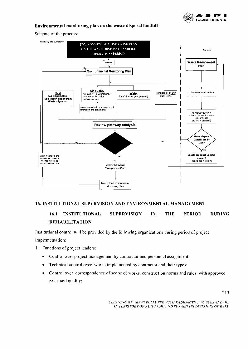
Environmental monitoring plan on the waste disposal landfill
Scheme of the process:
Ra~nfall water (preapltat~on), Soi l- radon a n d thoron;
Waste migration.
Noise and v~brat~on measuremen1 1 (transport and equpment)
1 Review pathway a n a ~ y s q
Adequate operations actlons (excavat~on work.
transportahon and waste disposal).
I Landllll an be
f\ es
Modify monltorlng and su~emllance plan wth closer? rncdlded rnonltor~ng and su~elllance plan L A
Modrfy the Waste Management Plan
I Modify the Environmental
Mon~tor~ng Plan
I
16. INSTITUTIONAL SUPERVISION AND ENVIRONMENTAL MANAGEMENT
16.1 INSTITUTIONAL SUPERVISION IN THE PERIOD DURING
REHABILITATION
Institutional control will be provided by the following organizations during period of project
implementation:
1. Functions of project leaders:
Control over project management by contractor and personnel assignment;
Technical control over works implemented by contractor and their types;
Control over correspondence of scope of works, construction norms and rules with approved
price and quality;
Provision of author control of project developer over works;
Participation in control by leading controlling organizations;
Control and guarantee of ecological safety of population, radiation and individual safety of
workers;
Control and guarantee over protective measures during transportation of hazardous cargoes;
Provision of trainings for personnel;
Control over implementation of Environmental Management Plan by Contractor;
Reception of works and objects implemented within project frames.
Project directorate will realize these tasks through representatives in project site.
2. Functions of contractor:
According to construction norms and rules implementation of land and civil and erection work
by accepted order and in timely manner;
provision of quality of land and civil and erection works;
providing of land and civil and erection works with requested equipment, technical means and
materials in timely manner;
provision of safety of implemented works, organization and protection of labor, organization of
different trainings;
correction of defects determined by Project directorate, project developer and leading control
organizations;
Provision of project impact mitigation through implementation of Environmental Management
Plan;
Preparation of reports on work process, determined defects and their correction and submitting
to ;
Submitting of Project works, prepared objects and final works to Project directorate.
3 . Functions of ((Izotop)) Special Center:
Provision radio ecological safety of project works;
Realization of radiological monitoring in project implementation sites;
4. Environmental Monitoring Department of Ministry of Ecology and Natural Resources:
Providing of ecological safety in project implementation sites and realization of ecological
monitoring.
5. Functions of construction safety Agency of MES:
-
Monitoring safe implementation of land and civil and erection works.
6. Functions of ((Dovlatdag-madantexnikinazarat)) Agency of MES:
Monitoring of land works to accepted construction norms and rules;
Monitoring of correspondence of equipment and technical means used for land and civil and
erection works.
7 . Functions of Fire Protection Agency of MES:
Monitoring of correspondence of project works to fire protection rules;
Monitoring over maintenance of combustive-lubricating material and installation of fuel
stations in correspondence with safety techniques requirements;
8. Functions of State Sanitary Service of MoH:
Monitoring over observance of sanitary-hygienic norms during project implementation.
9. Functions of State Labor Agency of the Ministry of Labor and Social Protection:
Monitoring over organization of labor in correspondence with norms and rules of labor
protection and health protection.
10. Functions of STP:
Monitoring and providing of safety of traffic operations within project activity.
16.2 INSTITUTIONAL SUPERVISION AND ENVIRONMENTAL MANAGEMENT
IN THE PEIIIOI) AFTER THE REHABILITATION
Institutional supervision and environmental management during the period after the rehabilitation shall
be carried out within the responsibilities specified by "Isotop" special center and includes the
following:
- Arrangement of the protection of the area of the site for burial of wastes in the specified way;
- Long term environmental monitoring
The following works shall be carried out for radiological monitoring of the mine and its surrounding
constructed for burial of coal wastes:
Doze effect of gamma irradation in the selected control points on the mine and its surroundings
shall be measured once a month. The measurements shall be carried out on the same points every
month for the purpose of comparison. Changes of doze effect of irradationyn each control point
shall be supervised. The results shall be recorded in time gamma;
Soil samples shall be taken once a month from the selected control points on the mine and its
surroundings. The samples shall be taken from different depths. Specific activity of natural
radionuclides in the contents of such samples shall be determined through the gamma-ray
spectrometer method. The samples shall be taken from the same control points every month for the
purpose of comparison. The samples studied shall be returned to the places they were picked up.
The changes in the specific activity of natural radionuclides in the content of soil shall be
supervised in each control point. The results shall be recorded on a time diagram;
a Once a month the volume activity of radon and its decomposition products on air shall be
measured in the selected points on the mine and its surrounding. The samples shall be taken from
the same control points every month for the purpose of comparison.Weather conditions shall be
recorded during the study (direction and speed of the wind, temperature, relative humidity) as the
weather condition has a big impact on such measurements. Bu olgmalara hava ~araitinin giiclii tasir
gostarmasi sababindan, tadqiqatrn aparrld~g~ zaman hava ~arait i qeyd olunacaq (kiilayin istiqamati
va siirati, temperatur, nisbi riitubatlik). The change of volume activity of radon and its
decomposition products on air shall be controlled in each control points. The results shall be
recorded on a time diagram;
a The level of ground waters are too deep, therefore water samples shall not be taken.
The purpose of this monitoring is to justify the secure storage of radioactive wastes and non-existence
of the negative impact of the current hazards on the helth of people and environment. As already
noted, the following environmental indicators are lacking on the area considered for construction of a
site for burial of wastes:
Ground waters;
Surface waters;
a Sensitive areas (settlements, archeological monuments, natural reserves and etc.)
Taking the above into consideration, the environmental monitoring shall include the observation,
measurement (analysis) and assessment of the following indicators:
Atmospheric air (determination of radioactive contamination level (radon gas));
Soil (determination of radioactive activated coal);

- Analysis of rain and run of waters against the contaminators;
Exogenous processes - geology (creation of holes and canyons and change of a landscape as a
result of climatic impacts and other natural events);
Biosphere (flora and fauna).
Supervision and management in the rehabilitated areas shall comprise of monitoring of such areas and
their neighbouring areas for a period of 3 years. These works shall be carried out by "Isotop" special
centre (radiological monitoring) and environmental monitoring department of the MENR. After the
works are completed in the manufacturing areas and beyond their borders, the monitoring after the
rehabilitation is to demonstrate the environmental cleanness, fully implementation of the goals, lack of
direct and potential impacts on the environment and people's health and compliance of the quality of
the soils to be rahbilitated with the objectives considered in the project.
The list of the readiological surveys planned to be carried out during the period after the project is
given below:
Table 16.1. The list of the readiological surveys planned to be carried out during the period after
the project
Spectrometric study of the samples taken for control of
Types of surveys
Dosimetric measurements in the rehabilitated areas of the site
I migration of radionuclides from the control points to the ~ Once a year
Priority
Once a year
surface layer of soil I
Besides, the following additional surveys shall be carried out once a year by the environmental
monitoring department of MENR:
Determination of the principal contaminators in atmospheric air;
Determination of carbohydrates in soi1;torpaqlarda karbohidrogenlarin miqdarln~n tayini;
Gamma planning of the surface for control purposes.
Measurement of radon and thoron volume activity on air 1 Once a year (windless weather)
volume of decomposition
products of radon and thoron on air
Dust density on air and determination of radionuclide volume
activity along with it
Once a year (windless air)
Once a year
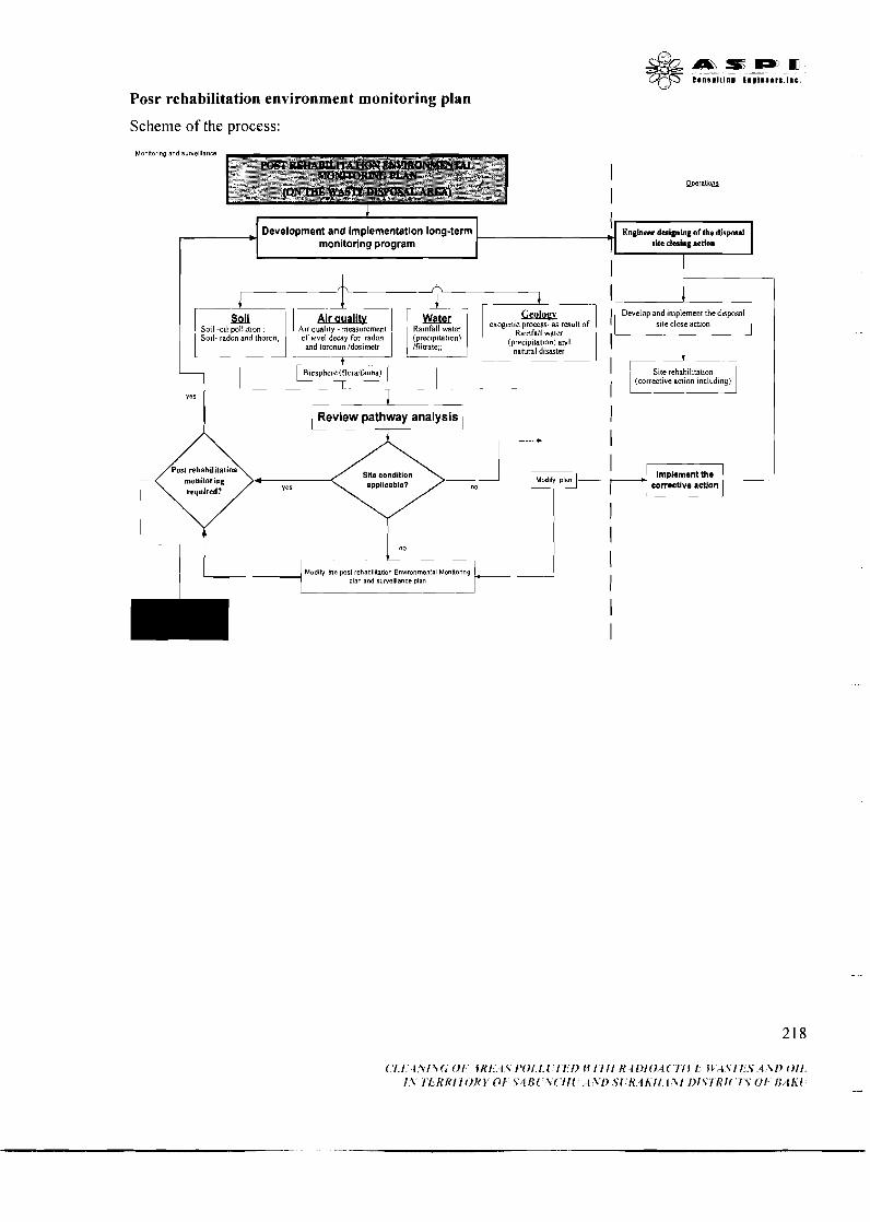
Posr rehabilitation environment monitoring plan
Scheme of the process:
Monlar na ana $.we ante
Development and implementation long-term Engineer designing of the dispcad monitoring program site dmhg action
I I
GwuY 1 S o - sod -oil a d ?, and t h o ~ I,4lf of level q%y(!?z?j decay for radon kd:;] 1 e x o 8 e n l k r g y i ~ e ~ ~
and toronun idos~metr (prec~p~tat~on) and natural d~saster
-7 7 --
2 r e v i e w pathway analysis '
, -
Modafy m e past rehab~litltlon Envlronmenlal Monnonng plan and ru~elllance plan
Develop and implement the dtsposal I
corrective action
('1.1.. i:Yl\(r 'Ol" l R l : . ~ l , T 1 ' O l . l . ~ ~ ~ ' l ~ l > 1.f 17'ii 8 ~1)10,4(~"7YJ 1:; JV; lTI l~.S,4; \ f~ O i l , 1 1 I ' i~ , 'KRl7OKV 0 1 ~ . S 4 1 ~ 1 ' V ( ' ~ I l ~ : ,.,i:Vl> .S l~R:~ IK i l . I S I I ) l .Sl~i t1( '7~S 0 1 ' ii/th'i
17. ENVIRONMENT MONITORING PLAN
17.1 IODINE PLAKTS AREA REHABILITATION COMPONENT
I to be monitored? I and equipment I Monitoring
Responsibility Phase I Monitoring parameters I Where the parameter / Testing Method I Periodicity of 1 7 h e reason to ( Instal Operates
Site rehabilitation
I I oil field lakes, ( method I
Dosimetry measurement
Soil pollution
( Canals, oil remover I Underground water - / Wells on the carbone I Wells, lakes I Quarterly
Soil- radon and thoron
Outside of the
radon and thoron I accumulation areas Underground water - oil I Wells on the anomal 1 p o l l u ~ ~ n 1 area 1 method --
Air quality -radon and Control point on the / radioactive I Quarterly (waste
Sampling on the abnormal area
qamma- Spectrometric method
. . thoron Air quality - megerment of level decay for radon
. .
determination of dust Control point
concentrasion and related
Quarterly
I and toronun
I level of radioactive I
anomal area Control point
I Air quality - I Daily
monitored by this arameters
"lzotop" Radioactive analytics biosphere laboratory of the Center
profiling method
Staff safety / "lzotop"/contractor I Specialists
handling) Daily
nucleides
analises of dust, sulphure dioxide, carbonmonoxide, nitrogen oxide and dioxide, phenol
Coulonomrtric method
Mobile noise tester
Tester
Noice
Dosimetrv measurement
NKS requirements
Quarterly
- Quarterly
Weekly
Control point on the bourd of residential area
Control voint
Underground water protection Underground water
laboratory of the Center
Environment and land use Ministry
protection Normslwork safety
Staff safety
Environment monitoring laboratory
"lzotop"
Environment and
Radioactive analytics laboratory of the Center Environment monitoring
land use Ministry "Izotop"
"Izotop"/contractor
Norms requirements
Staff safety ( "Izotop"1contractor ( Specialists
laboratory Radioactive analytics laboratory of the Center Specialists
I I
Environment and land use Ministry
Environment monitor& laboratory
Environment monitoring laboratory
Population safety Environment and land use Ministry
r I d e of the reabilitation I I I I
I radon and thoron I accumulation areas 1 Underground water - oil / Control ! point (residual Monitoring wells
helth
Soil - radon and thoron rehabilitation
I po~~utibn wastes) - 1 llaboratorlaboramj I Air aualitv - radon and Control point on the radioactive
anomal area I profiling method Staff occupational helth Polyclinic of IZOTOP I Medical check- +* -
Polyclinic of IZOTOP
Sampling (residual wastes)
Sampling close to the oil field lakes, Canals, oil remover Wells on the carbone
-- Medical check- UD
qamma- Spectrometric method -- Sampling
Monitoring wells
Quarterly
Quarterly
Twice /year 1 Underground water I "lzotop" I Radioactive analytics
Twice /year (annually)
Staff safety 1 Norms requirements Staff safety
Transportation component
Environment and land use Ministry "lzotop"
Harm to the biosphere
(annually) Twice /year (annually) Twice /year (annually)
m w
I N o r m Once a year requirements
Instruction Weekly
"lzotop"
protection Underground water protection Norms requirements / work safety Staff safety
Dump-trucks, special lorry
Safe transportation
Radioactive analytics laboratory of the Center
Checkup
--- Helth safety, Emergency response,
Environment and land use Ministry "Izotop"
"lzotop"
motor licensing and inspection
laboratory of the Center Environment monitoring laboratory Radioactive analytics laboratory of the Center
department "lzotop"1State technical control
Kontrol department
--
Transportation department
department1 traffic safety licensing and
inspection deoartment
Landfill for the Radioactive Waste Disposal
- (PPE)/test equpment
Constriction phase
Coulonomrtric analises of dust, method sulphure dioxide, carbonmonoside, nitrogen oxide and
Transports
-
I dioxide, phenol I Noise /viabration / Equipments ( Mobile noise
Quarterly m"'"'....'. Quarterly Population safety
Norms requirements
I I I tester 1 I
Staff safety / Norms
Daily
Operation phase
licensing and inspection department
Air quality - radon and thoron radon and
sulphure dioxide, 1 1
thoron Air quality -chemical analises of dust,
carbonmonoxide, nitrogen oxide and
Control point
dioxide, phenol Soil - radon and Control point thoron Spectrometric
radioactive profiling method
Control point
I method -- Soil 4 1 polution I Sampling I Spectrometric
Coulonomrtric method
I work safety Quarterly I Norms
Quarterly (waste handling)
requirements
Norms requirements /
biosphere
I
Twice /year I Norms 1 method I requirements
helth (PPE) ( IZOTOP
land use Ministry laboratory
I Medical check-up I Quarterly / Staff safety
Geology 1 Wells (monitoring out of turn force majeur)
I Twice /year I Harm to the biosphere
land use Ministry I laboratory Environment and Environment monitoring
MrICM30TOll
"Izotop"
Radioactive analytics laboratory of the Center
Environment and land use Ministry
Radioactive analytics laboratory of the Center
Environment monitoring laboratory
Environment and I ~ n v i r o x e n t monitoring land use Ministry "Izotop"
- laboratory Medical center
Contractor Contractor
Rainfall water(precipitation)/f iltrate
Long term monitoring (landfill
Air quality -radon and thoron
Soil- radon and thoron
Geology -7
Sampling from Radioactive analytics laboratory wells of the Center
RadioKombinat~n radioanalitik requirements / laboratoriyas~nda analiz work safety
Sampling qamma- Spectrometric I Once a year I
I method Wells I Twice /year
(monitoring out of turn force majeur)
Harm to the "lzotop" Environment monitoring biosphere laboratory
Sampling from wells
Harm to the I Contractor I contractor biosphere
Monitoring wells --lzotop" T t o t h e ~ a ~ a n a l y t i c s biosphere laboratory of the Center water(precipitati
17.2. ENVIRONMENTAL IMPUCT MITIGATION PLAN
e person CONSTRUCTION I-
Commence Mitigation action Institutional responsibility Organization I Responsibl
Manager Inspector
Manager Inspector
Inspector
- - - - - ~ - -
Regular technical checkup and service, prevention of
1. Construction of overcharging and control over speed of machines and mechanisms
abutment wall in Regular technical checkup and service, prevention of overcharging and control over speed of machines and mechanisms, using of individual protection measures
2. Disposal landfill
Contractor, Ministry o f Emergency Response ((Constaction safety)) Agency, Ministry o f Health -State sanitation department Contractor, Ministry o f Emergency Response ((Constaction safety)) A ~ ~ ~ ~ ~ , ~ i ~ i ~ t ~ ~ o f ~ e a l t h -state sanitation department
Regular technical checkup and service, prevention of overcharging and control over speed of machines and
mechanisms
Transport and Fuel
Industrial and domestic waste
Air polution
Dust polution
223
Ministry of Emergency Response ((Technical safety)) Agency, Ministry of Health -State sanitation department
Provision of safety measures and preventive fire-fighting regulations, surrounding of fuil kept areas with soil,
structures for cleaning of accidentally poured fuel, fue safety equipment, trainings for personell
Waste collection and disposalltransportation to the disposal area
Reqular t echca l control and sewise, prevention of the norms excess and control the nachine and equpments
movements
Moistering of polluted areas with artificial rain. control over speed f machines and mechanisms, using of personal safety
equipment by personnel.
Manager lnspector
Inspector
Contractor, Ministry o f Emergency Response ((Fire safety)) Agency,
Contractor, Ministry o f Health -State sanitation department
Ministry of Emergency Response ((Technical safety )) Agency, Ministry o f Health -State sanitation department
Ministry o f Emergency Response ((Technical safety)) Agency, Ministry o f Health -State sanitation department
Inspector
Inspector
Manager lnspector
inspektor Manager Inspector
Inspector
Qrunt su lar~nin qirklanmasi ehtrnal~nln artmasi
Qrunt s u l a r ~ n ~ n qirklanmasi ehtmalln~n artmas1
Torpagln sathinin va qonvu arazilarin qirklanmasi
Transport and Fuel
Industrial and domestic waste
Provision of safety measures and preventive fire-fighting regulations, surrounding of fuil kept areas with soil,
structures for cleaning of accidentally poured fuel, fire safety equipment, trainings for personell
Waste collection and disposalltransportation to the disposal area
sanitation department Inspector
sanitation department Inspector
qirklanmasi ehtmalln~n artmas1
Exogenic process
qirklanmasi ehtmalln~n artmas1
Implementation of construction works by using Contractor, methods and technologies for prevention of exogenous Response ((Constaction safety )) Inspector
processes Agency, ((Technical safety n Agency Inspector
REHABILITATION 1. Decontamination Air polution
Dust polution
Regular technical checkup and service, prevention of overcharging and control over speed of machines and
mechanisms
Moistering of polluted areas with artificial rain, control over speed f machines and mechanisms, using of personal safety
equipment by personnel.
Contractor, Ministry of Emergency Response ((Constaction safety)) Agency, Ministry of Health -State sanitation department Contractor, Ministry of Emergency Response ctconstaction safety s Agency, Ministry of Health -State
Manager Inspector
Inspector --
Manager Inspector
1 sanitation department Inspector technical checkup and service, prevention of I Ministry of Emergency
i overcharging and control over speed of machines and ((Technical Agency, Ministry ~~~~~c~~~ mechanisms of Health -State sanitation
I department I Inspector Trans~ort and t I Provision of safety measures and preventive fire-fighting I Contractor, Ministrv of Emereencv I Manager ( Fuel ' regulations, surrounding of fuiikept areas with soil, / Response r ~ i r e nniety n Agency, " I 1nspe:or
structures for cleaning of accidentally poured fuel, fire safety
i Industrial and domestic waste
va qonsu arazilarin qirklanmasi
during Landwork
qirklanmasi ehtmalrn~n artmasl
equipmint, trainings for bersone~~ Waste collection and disposalltransportation to the disposal
area Qrunt su la r~n~n qirklanmasi I
Implementation the complex cleaning action of the local polution arae
1 I I I
Land I Implementation the complex cleaning action of the I ((Izotop)) SC 1 Director
Contractor. Ministry of Health -State sanitation department
sanitation department Inspector
Manager Inspector
contamination during waste
local polution arae
o f cop\mplex measures for cleaning o f / Contractor, iilzotop)) S C I Manager I during waste 1 - local pollution 1 / Director 1
disposal action
rehabilitation area Regular technical checkup and service, prevention of overcharg~ng and control over speed of machines and
mechanisms
Contractor, Ministry o f Emergency Response ((Constaction safety )) Agency, Ministry o f Health -State
polution (residual
Manager Inspector
POST REHABILITATION
1 impurity)
Dust polution
Noise
Transport and Fuel
Industrial and domestic waste
local radioactive polution arae ImpIementation the complex cleaning action o f the
Moistering of polluted areas with artificial rain, control over speed f machines and mechanisms, using of personal safety
equipment by personnel.
Regular technical checkup and service, prevention of overcharging and control over speed of machines and
mechanisms
Provision of safety measures and preventive fire-fighting regulations, surrounding of fuil kept areas with soil,
structures for cleaning of accidentally poured fuel, fire safety equipment, trainings for personell
Waste collection and disposal/transportation to the disposal area
1. Postrehabilitation action rezalt Assesment
Implementation the complex cleaning action o f the local oil polution arae
Oil polutin (residual impurity)
Contractor, c t Izotop~ S C
sanitation department Ministry of Emergency Response ((Technical safety M Agency, Ministry o f Health -State sanitation department Ministry o f Emergency Response ((Technical safety )) Agency, Ministry o f Health -State sanitation department Contractor, Ministry o f Emergency Response ((Fire safety)) Agency,
Contractor, Ministry o f Health -State sanitation department
Director C Contractor, ctlzotop)) S C Manager
Inspector Manager Inspector
Inspector Manager Inspector
Inspector Manager Inspector
Manager Inspector
Torpagln sathinin va q o n y arazilarin qirklanmasi
Qrunt sularlnln qirklanmasi e h t m a l ~ n ~ n artmas1
Qrunt s u l a r ~ n ~ n qirklanmasi ehtmallnln artmasl
18. PUBLIC PARTICIPATION IN THE PROJECT
18.1. ATTRACTION OF PUBLIC TO EIA PROCESS
As a first step to implementation of the EIA there was conducted a social impact assessment of the
project, in the framework of which meetings on information of local population living in localities,
adjoining to design areas and situated along the route of transportation of waste to disposal sites were
conducted and also a public opinion poll regarding project's goals and objectives and ways and
methods of their realization was implemented.
Next steps were initial public hearings conducted at 19 December 2007 with a view of consultation
with public representatives, NGOs, municipalities on issues relating to assessment of current
environmental situation on polluted areas, ways and methods of their cleaning and rehabilitation and
assessment of environmental and social impact of proposed works both on location of contaminated
areas and on location of disposal sites. Number of comments and recommendations stated by public
representatives was taken into account at drawing-up of final EIA document.
Presentation and discussion of EIA document were conducted at 7 February 2008 with participation of
representatives of scientific societies, NGOs, municipalities, stakeholders and mass media. A
statement on presentation was issued beforehand in newspaper "Azerbaijan" (1 February 2008) for
providing an openness of hearings and achieving of maximum information of population about EIA.
On presentation copies of EIA documents were submitted to participants for direct acquaintance and
also extensive report on EIA results was listened.
18.2. PLANNING PUBLIC PARTICIPATION IN PROJECT IMPLEMENTATION
After receiving of official conclusion on EIA from MENR, the EIA document will be published and
placed on websites of WB and the Azerbaijan Ministry of Emergency Situations (AMES) for
information of wide public circle about assessment results.
Later there is planning implementation of the following actions covered period of preparation to
works, during construction and rehabilitation works and in the post-rehabilitation period:
- meetings in the provinces in pre-project stage with the purpose of information of local
population with EIA results, project stages and tasks that will be implemented in the process of
works;
- periodic meetings in the provinces in the project implementation period with the purpose of
familiarization of local population about progress of works and achieving results on work
stages;
- periodic lighting of work progress and achieving results on work stages in mass media;
- providing of transparent ecologic results of the project by involving of representatives of non-
governmental sector to ecological monitoring;
& m n : I P m L@- C I r n I I I I I I r n 1 1 ) , 1 r n ~ . 1 1 l l C
- conducting of annual public hearings, round-table discussions and conferences concerning
progress and results of works;
- meetings in the provinces in the poet-project stage with the purpose of information of local
population with final results of project and achieving environmental effects;
- wide lighting of project results and achieving environmental effect in mass media.
REFERENCES
1. aliyev F.S. Azarbaycan Respublikas~nda ekzogen geoloji proseslar, onlarln oyranilmasi metodu va proqnozu prinsiplari - Bak~, "Tahsil" 2002
4. 3ary6a K. M e ~ r l n B. M ~ x e ~ e p ~ a ~ reonorwrr, Mwp, 1979r.
7. A 6 6 a c o ~ M.M., ( D C ~ ~ H O B (D.A., K ~ C ~ M O B A.M. KpaTKMfi CIlpaBOqHMK no oxpaHe M rMWeHb1 Tpyna, JIbrOTaM M KOMneHCalJHRM 3a pa6o~y B H ~ ~ J I ~ ~ o I I ~ M H T H ~ I x yCnOBMHX Tpyna - ~ K Y , M3naTenbCTBO ((Cans)), 1996r.
8. Am-sane A.A. A X M ~ A O B T.A., A X M ~ A O B A.M. M np. reonorkia H ~ @ T W H ~ I X M ra30BblX M ~ C T O ~ O X ~ ~ H H ~ ~ AsepGafinxa~a, M ((Henpa)) 1966r.
9. Hcpa@Mno~ T.IO. n w c ~ e ~ r e p ~ e ~ B.A. T P Y H T O B ~ I ~ B O A ~ I M OcBoeHwe 3 e ~ e n b Anruepo~a, E a ~ y , Asep~erup, 1978r.
10. Yusifov E., lsayeva N., asgarov F. Bioloji miixtaliflik: Ab~eron yarlmadaslnln tabiat abidalari. Bakl, "Nurlar" NPM, 2007-ci i
1 1. C ~ O P H A K HOPMaTABHblX MaTepAanOB no OXpaHe 0 K p y ~ a ~ q e f i CpeAbI. M o c ~ s a 1987rr.
12. Azarbaycan Respublikaslnln atraf Miihita dair Qanunvericilik toplusu., ETSN - 2002il.
13. Azarbaycan Respublikasln~n atraf Miihita dair Qanunvericilik toplusu., ETSN - 2002il.
14. Remediation of Areas Contaminated by Past Activites and Accidents, No-WS-R-3 (IAEA) - IAEA Safety Standards Series
15. Remidiation of sites with dispersed radioactive contamination (tekhnical reports series No. 424 Vienna, 2004.

PART I1
ENVIRONMENTAL IMPACT ASSESSMENT
ON THE PROJECT
"CLEANING OF ONE THOUSAND
HA OIL-CUT AREA
IN ABSHERON
PENINSULA"
{ l . l i . i . \ l \ ( , O F ' ~ K ~ ~ ' . . l , ~ l ' O ~ , ~ , l ' / ~ f ~ / ~ I f / I l l ~ , ~ ~ t I ~ l O , . ~ ~ ~ I ' ~ t ' l , ~ ~f:~lslY,'.s ,.i;\i) 4 l l I - I.? 7 W K K l I ' O K Y O i ' S 4 l , ' l : ? ' ( ' I l l . ' , f \'D SI:H I E I I 1 \-I DlS?'III(.I':S 01. B i t h ' l ' --
INTRODUCTION
More than 130 years ago, the world's first industrial development of oil resources has started in the Absheron peninsula of Azerbaijan. Exploration of oil deposits enabled nation's economic growth and rapid extension of Baku to become region's biggest city and industrial center. So far, over 1 billion tons of top quality "black gold" have been produced, refined and exported from the country.
However, besides the economic benefits, oil production was also known for its' negative environmental impacts due to the deployment of extensive and environment-unfriendly exploration and refining technologies. These impacts caused long-term contamination of soil, superficial and ground waters as well as deterioration of region's biological diversity. As a result of fact, once productive lands formerly used for gardening and pastures were exposed to merciless man-caused contamination, becoming lifeless polluted deserts full of oil lakes and patches.
Oil-field brines and spillage together with oil products and slime from the refineries and oil-chemical plants formulate the inventory of peninsula's environmental contamination. Topsoil concentration of oil and its' products (0-5 cm below ground) by 10-60, sometimes 100 times exceeds region's background levels. The depth of hydrocarbons' soil penetration averages at 2.0-2.5 m, while the ground contamination levels between 1-2 % and 20-30 % depending on site characteristics.
The total area of Azerbaijan's oil contaminated lands makes up 20,000 ha, of which over 10,000 ha are situated on Absheron peninsula. More than 2,000 ha of the peninsula's lands are polluted up to the depth of 20-30 cm and over. These areas contain the average volume of 20-30 million tons of oil and oil products. Annually, more than 15,000 tons of oil and its' products are transported by drainage systems of oil fields and refineries to contaminate water of inner reservoirs and the Caspian Sea. Only the Baku Bay has 64 million m3 of bottom sediments that contain 2-40 % of oil organics.
Complete remediation of the polluted areas of Baku, Absheron peninsula and adjoining Caspian Sea requires urgent action to decontaminate soil as well as the oil field and plant drainages from different oil, oil products, slime, chemical and other contaminants.
Rehabilitation of lands' productivity as well as the opportunities for secondary use of cleaned wastewater and oil extracted from decontaminated soil, are the economic benefits expected from proposed remediation activities.
Environmental benefits of these activities include but are not limited to the rehabilitation of region's natural landscape and biological diversity.
& & m f ; B D m 3 6 C l l l l l l l l l LnIIII.1r)I.e.
I. PROJECT JUSTIFICATION, GOALS AND OBJECTIVES
Remediation of oil-contaminated areas is most critical for densely populated regions with scarcity of lands that are appropriate for urban development. One of such areas is situated in the peninsula's northeast between densely populated Mashtaga, Zugulba, Buzovna and Bilgah villages. Shortage of perspective land may be compensated by a rehabilitation of heavily contaminated oil fields that currently belong to "Buzovnaneft" Oil Production Enterprise of SOCAR. Oil exploration activities have almost stopped and most equipment have been disassembled in this formerly perspective oil fields.
Following two problems will be solved, once these areas are completely remediated and passed over to the ownership of local municipalities:
1. Cardinal improvement of the environmental situation of densely populated project area;
2. Creation of favorable conditions for the rational land-use and strengthening of region's social and economic capacities.
Site proposed for pilot remediation is situated between villages of Mashtaga and Buzovna, and occupies the total area of =:lo00 ha. Site stretched along the main road that connects these two villages. Area's length is 7 km, while its' width averages at 1.5 km. It is identified that the existing oil contamination resulted from long-term spilling of oil and oil products from the reservoirs, pipelines and oilers. Under the impact of local climatic conditions, cruel oil hydrocarbons have transformed into the heavily polymerized substances that impregnated the soil with tarry matter and multiring hydrocarbons. As a result of fact, thick layers of bitumen have emerged at the areas subject to a long- term spillage.
Self-decontamination of the oil-polluted earth is limited by high concentration levels of the contaminant, low humidity and shortage of biogenic elements in soil's structure.
Different types of soil contamination are present in the described area:
- hydrocarbon oils (fuel oil, oil);
- solid oils (bitumen, oil slimes);
- oil-contaminated soil;
- local radioactive contaminations;
- biologically contaminated soil by different municipal waste;
- mechanical contamination by debris, concrete and metallic materials.
1.1. GOAL AND OB,JECTIVES
Ultimate goal of the proposed initiative is in pilot decontamination of the oil-polluted lands of Azizbekov administrative region of Baku, with their total environmental and biological rehabilitation.
Project objectives consist of the following components:
1. Cleaning of sites from on-surface industrial and municipal wastes;
2. Removal of oil contaminants from the 2 m thick polluted topsoil. Soil clean-up will be implemented with the deployment of physical-mechanical decontamination technologies so that the soil concentrations of hydrocarbons reduces to 10-15% of the initial values;
& & A T & s - m QcF C l i l # l l l l l l 1 1 9 1 1 1 1 r l 1.C.
3. Afterpurification of contaminated soil with the use of biological clean-up technology so that the concentration levels reduce to 0-1% of the initial values;
4. Treatment of oil-field brines (if any) with the use of physical-mechanical decontamination technology so that the respective concentrations of hydrocarbons reduces to 10-15% of the initial values, and reused water becomes suitable for technical needs;
5. Landscape planning and remediation of the decontaminated sites, pilot plantation of trees.
The long-term goals of the proposed initiative is in a) total rehabilitation of' area's biological productivity, b) mitigation of man-caused environmental impact, c) mitigation of deforestation and landscape degradation processes, and d) reintroduction of area into the economic circulation.
1.2. EXPECTED OUTCOMES
Following outcomes are expected to be produced as a result of project implementation:
1. Complete decontamination of the polluted soil or the reduction of their hydrocarbon concentration levels to reach 0.5-2.0 % of the initial values;
2. Unrestricted release of remediated lands for agricultural use or urban development;
3. Improvement of district's social and economic parameters as due to the acquisition of additional clean lands;
4. Testing of environmental, economic and technical applicability of oil clean-up technologies in the Absheron peninsula;
5. Improvement of district's environmental situation.
1.3. BENEFITS AND PRIORITIES
a. Local environmental benefits: - Rehabilitation of land's productivity and biological diversity of the pilot area;
- Prevention of soil degradation, rehabilitation of area's land resources;
- Prevention of discharge of the unpurified wastewaters produced from the oil fields;
- Mitigation of air contamination levels by reducing the emission volumes of volatile hydrocarbons.
b. Socio-economic benefits for the local population - Improvement of the human environment; - Improvement of working conditions of the oil industry workers; - Opening of new temporary job opportunities through the involvement of local population into
remediation activities; - Improvement of local infrastructure through the development of project-related communication
networks (roads, water supply, electrification, etc.).
u c. Environmental priorities - The project will be designed and implemented in accordance with the National Environmental
Action Plan and help achieve its' primary objectives;
- The project will help implement national commitments under the "Agenda XXI".
1.4. PROJECT'S ROLE IN TIIE PROBLEM RESOLUTION
Project outcomes as well as the technical solutions and recommendations developed within its' implementation framework, will form practical basis for proceeding with later wide-scale decontamination and complete remediation of the oil contaminated territories of Azerbaijan. This will also serve as example of successful cooperation between government agencies, private enterprises and local communities in the area of battling the negative environmental impacts existent in the country.
All these factors will promote the achievement of region's sustainable development and environmental rehabilitation. Elucidation of project achievements in media will help formulate public activity in the problem's scope.
2. GOALS AND OBJECTIVES OF FRAMEWORK EIA
The Framework EIA has the ultimate goal to characterize current environmental situation of the pilot project area and propose negative impact mitigation methods for project implementation.
The study has the following objectives:
- Characterization of the physical condition and contamination parameters of the pilot site;
- Survey of decontamination technologies and proposed project implementation methods;
- Environmental and social impact assessment for project activities.
3. ENVIRONMENTAL CHARACTERISTICS
3.1. TOPOGRAPHY AND GEOMORPHOLOGY
Pilot site is situated on northern margin of Bina-Hovsan abrasion-denudation inclined plain with slightly undulating land that favors the creation of temporary flows during precipitation. Flows usually run in the southern direction and often accumulate in small blind hollows. Reliefs absolute altitudes vary between -20 m along site's northern border, and +I0 m towards its' southern edge. The area is inclined from the west (+20 m) towards east (+lo m) with the average altitude of +15 - +17 m.
3.2. GEOLOGICAL STRUCTURE
Pilot site surface is composed of up to 2 m thick Holocene eluvial-dealluvial sandy loams sub- horizontally bedded by rocks of the Khazarian layer (Qzhz). The latter are presented by limestone and shelly rocks and limestone, sands and clays in the deeper section.
The thickness of middle Pleistocene sediments reaches 40-50 m. These sediments transgressively overlap (with azimuthal and cross bedding) gently dipping ( 3-10') rocks of the upper sub-layer (Eopleistocene) of Absheron layer. Sublayer is also composed of limestone, sands, sandstones and clays.

Site is situated on Buzovna-Mashtaga oil deposits accumulated in different ~liocene productive layer horizons ( ~ ~ l ~ r ) . Oil exploration depth in the area reaches 1300 m.
Pliocene within deposit's area creates two (Mashtaga and Buzovna) buried highs with the composite structure. Highs are interconnected by gentle saddle with East-South East extent. All oil bearing beds are in the latest stage of exploration. Oil is only produced from separate development wells, on which the water injection is practiced to support adequate oil production volumes.
3.3. GROUND WATERS
According to drilling data of 2006, the ground water table at pilot site varies between 1.5 and 2.0 m. However according to data of 1970's the ground waters used to lie at a 5 m depth at that age. Increase of the water table is mainly due to the flooding of North-Eastern Absheron as a result of water leakage from Samur-Absheron canal as well as infiltration of the irrigation water and sewage from neighboring settlements.
Area's ground waters mainly have hydrocarbon chemical composition. Waters are sweet and slightly saltish with the mineralization level of 0.3-2.0 g/l. Surface of grey-blue clays of the upper Absheron (Qla3) serve as a Khazarian layer's confining bed to the described ground waters. Pressure waters are discovered among limestone and sands of the middle Absheron sub-layer at a depth of up to 150 m. These waters are sweet and slightly saltish with the mineralization level between 0.4-5.4 and 40.5 g/l.
Well production is considerable in both ground and pressure waters - they make up to 3.3-3.5 1/sec with the specific yield of 0.5-0.7 1 Ilcrn.
3.4. SOIL AND LAND-COVER
20 cm Sabulous-sierozem soil prevails at the territory of pilot site. Ephemeral semi-desert vegetation grows at the site, development cycle of which corresponds to the annual precipitation cycle. Ephemerals sprout during autumn and turn green in winters. Plants dry out in May and their seeds remain in soil until next autumn.
4. ENVIRONMENTAL CONDITIONS AND CONTAMINATION ASSESSMENT
4.1. OIL WASTES AND OIL CONTAMINATED SOILS
According to implemented preliminary research, there are over 15 areal and multiple local contaminations within the site's boundaries. Following contamination types were discovered in the area:
a. Open oil sumps
For years, the extracted oil used to be filled into the open-air oil sumps for further transportation to the refineries. Currently there are numerous pits remaining full of bitumen and covered with soil.
b. Local concentrations of fuel-oil residues combined with soil
From time to time, specific areas used to be allocated for the open-air disposal of oil-contaminated soil withdrawn from the overcontaminated areas or abandoned oil sumps.
( -1.1,' I \ 1 . w ; o f ' t RI: . I , S I ~ O I - I . r. 7 . t . ; ~ ii 17.11 K . . ~ I I I ~ .$ ( 1.1 1 '1: 11 :"I,Y 1.1i.s ~I;\LI 0 1 1 . I.? 7 ' l R l < l / ' O R } , O / " . S , ~ l l ~ ~ ~ ~ . ? ~ ~ ~ l / l ~ . I \ I ) .Sf-R 1 h ~ I l : i ~ V I , ! ) l . Y T i ~ l ( ' l ~ S 0 1 . £ l . . , iKi
- c. Drill cuttings and oil-contaminated soil
This contamination type is widespread throughout all operating and abandoned oil fields of the peninsula. Drill cuttings and oil-contaminated soil are one of the most complicated subjects to decontamination.
d. Contamination occurred as a result of oil escapes from the transportation pipelines.
Areas contaminated due to the oil escapes amount to 3,000 ha throughout the pilot site.
e. Lakes emerged because of the stratal water inflow.
Stratal waters produced from the oil fields, used to be transported to the special reservoirs where they formed artificial lakes with increased oil contamination parameters. Currently the lakes have already dried out, while considerable contaminations by oil products and other chemical pollutants remained at their bottoms.
Oil fields and their surroundings are all characterized by increased pollutant concentrations even if no direct oil contamination occurred there. Therefore, there is an urgent need for complete biological remediation of the entire project area.
4.2. RADIOACTIVE WASTE
One of the environmental concerns related to oil production is the radiological contamination of the production sites. Contamination sources from natural radioisotopes contained in the stratal waters accompanying the oil. Although isotope concentrations are quite low in each cubic meter of the extracted water, the radiological situation becomes worse when millions of tons of the water come to a surface. Excessive accumulation of stratal waters leads to higher radium concentrations at a relatively small area. There are two paths by which radium isotopes get accumulated:
1. Sedimentation of radioisotopes and creation of radiobarites on the bottom of artificial stratal water reservoirs (lakes);
2. Dumping of scraped radiobarite sediments accumulated on the walls of pipelines used to transport oil and stratal waters.
Therefore, oil field concentration levels of radioisotopes are expected to be above the norm. This might be also asserted about project area. Implementation of special radiological survey is needed to identify the radiation background of pilot site.
4.3. OTHER TYPES OF WASTE
Various kinds of non-oil and non-radiological waste are accumulated throughout the entire project territory, to include construction debris, concrete blocks, industrial and municipal waste. Contamination volumes and area increase with time under the practical absence of any kind of control by the territory's owner (SOCAR).
5. PROPOSED CLEAN-UP TECHNOLOGIES AND PROJECT MILESTONES
Preliminary site characterization demonstrated that 30% of the total project area are contaminated by oil and oil products. Depth of soil contamination varies between 1.0 m and 1.5-3.0 m below the ground level. The volume of contaminated soil is estimated to make up 3.0-3.5 million m3 (5.25-6.1 million tons) with the pollution level of 1-2% through 20-30%. Existing contamination levels considerably exceed the similar parameters of sludge and oil storage pits. Such circumstances require deployment of combined physical-mechanical (physical-chemical) and biological decontamination methods. The soil with 10-15% content (10 % of total pilot area) of oil and oil products should be exposed to direct biological decontamination, while the more heavily contaminated land must first go through the preliminary physical-mechanical (physical-chemical) treatment.
Proposed combined technology implies on-site construction of the one or several modular technological lines, the capacity of which allows rapid decontamination of the polluted area (3 years or 792 workdays). Given the forecasted decontamination volumes (1,000 ha x 10,000 m2 x 20% x 1.0 m = 2,000,000 m3 or 3,500,000 tons), the total capacity of physical-mechanical treatment equipment must constitute 4,400-4,450 tonslday, i.e. 550-560 tonslhour under 8 hour work day or 275-230 tonslhour under two-shift operation.
Deep purification of heavily contaminated soil should consist of two consequent cycles to include following components:
1. I " cycle - physical-mechanical (physical-chemical) treatment of soil:
- extraction and transportation of soil to the treatment area;
- decontamination of soil at the processing line;
- storage and drying of cleaned soil;
- post-treatment selection of soil samples to identify their residual hydrocarbon content.
2. 2"* cycle - posttreatment of soil by a biological method, rehabilitation of soil's biological productivity:
- transportation of cleaned soil to its' initial dislocation area;
- leveling of reintroduced land;
- introduction of mineral fertilizers (nitrogen, phosphorus, potassium) and fine straw, saw dust, microbial preparations and other ingredients;
- watering of soil so that its' humidity level is maintained within 30-40% of full field water capacity;
- periodical tillage for aeration -twice per month;
- periodical collection of samples to evaluate the quality of soil;
- transfer of the rehabilitated land to the respective hands.
Expected outcome - complete clean-up of the oil-contaminated soil or reduction of its' hydrocarbon concentration levels to reach 0.5-2.0 % of the initial values
V
5.1. PHYSICAL-MECHANICAL TREATMENT TECHNOLOGY
This technology builds upon the separation principle of the materials based on their solidity and specific weight. Separation takes place in the special centrifugal motion dispersers. Hydrodynamic processes running in the dispenser lead to the maximum dispersion of bituminous argillo-arenaceous particulates of oil contaminated soil and separation of the suspension mixtite into different fractions. Recurrent chains of the technological process include reused water treatment of oil-contaminated soil, during which oil fraction separates from the argillo-arenaceous and water fractions and distinguished oil products get transferred to the bank. Then the used water goes to a secondary use, while deposited argillo-arenaceous mass is exposed to a biological treatment pending dehydration and drying. Hot water or 110-120'~ steam is supplied to a dispenser's working cavity whenever deep purification of oil-contaminated soil with high concentrations of asphaltic bituminous fractions. The process deploys circulating bleedless water supply system. Technological scheme is designed so that it prevents secondary contamination by extracted hydrocarbons.
Conceptual technological scheme of the physical-mechanical treatment of oil-contaminated soil is presented in Figure 1. Described below are the technological chains and sequence of the soil treatment activities:
1. Pre-preparation of soil. This chain includes preliminary tillage of contaminated soil and removal of large metallic pieces, rocks, wood and other industrial and municipal waste. Produced intermediate product is sent by band conveyor to a storage hopper equipped with barscreen and vibrators. Here the charge stock gets further disintegrated and supplied to electrical vibrosieves for the separation of fine rocks and other solid material. Pending the removal of solid fractions, soil is supplied to a dispersion unit.
2. Ground dispersion. This chain includes separation of intermediate product when mixed with the cold water. Following two separator types may be used herein:
- disperser mixers used in the centrifugal motion and dynamic sedimentation units;
- multi-profile use super adjuvant unit.
3. Washing cyclone block. Major suspension mass is separated from pulp and returned to a secondary disperser mixer. There the mass is mixed with reuse water and pumped to a sedimentation unit by mud jack.
4. Sedimentation unit. Two-step sedimentation system is deployed here to consist of the two blocks of vertical and horizontal sedimentation. Pulp is being supplied to vertical sedimentation tanks under residual pressure. Here the fractionating of pulp occurs: disperse particles settle, while the water-oil emulsion goes to the horizontal sedimentation tanks. These tanks are the special thin-layer oil removers designed to separate water and oil fractions, and to settle the residual amount of fine-dispersed fraction of the parent soil. Extracted oil and oil products are first supplied to the oil remover's central collection chamber where final separation of oil and water occurs. Oil-field wastewater is also supplied to this unit for the removal of oil.
Then, dehydrated hydrocarbons are transported by pipelines to the special reservoir-storages.
5. Storage of cleaned soil. Storage unit consists of two sectors. First sector comprises reservoir- storages of secondary hydrocarbon material. The second sector collects and dehydrates bituminous argillo-arenaceous mass supplied from the sedimentation tanks. The material is transported by dump trucks.
. .- Both local and foreign physical-mechanical treatment technologies may be used during proposed
pilot site rehabilitation activities.
S Q G ~ S E ~ O y - * C#.,.Itl.. ~".l..#,# I..
Existing local technologies are distinguished for their high capacity (92-98 % of cleaning), relatively low capital and operation costs, and include the following:
- Physical-chemical treatment equipment with the capacity 20 m3/hour (35 tlhour), produced by SOCAR. Operation method - cleaning by process water at 50-60 '~ with the use of surfactant species. Installation cost - 250,000 AZN, cleaning cost - 12-14 AZNIton.
- Physical-chemical treatment equipment with the capacity of 15 m3/hour (25 tlhour), produced by CRS. Operation method - cleaning by process water at 50-60 '~ with the use of surfactant species. Equipment is certified in 2001 within the framework of TACIS project # EAZ 9801. Installation cost - 70,000 AZN, cleaning cost - 12-14 AZN/ton.
- Modular physical-chemical treatment equipment with the capacity of 10 thour (increase of the capacity may be obtained through the installation of additional major components), produced by Special Integrated Design Department for the Treatment of Minerals of Azerbaijan National Academy of Sciences. Operation method - cleaning by process water at 50-60 '~ with the use of chemical agents according to recycling principle. This equipment is a pilot unit, which was also certified under TACIS project # EAZ 9801. Installation cost - 700,000 AZN, cleaning cost - 12-14 AZN/ton.
- Modular physical-chemical treatment equipment with the capacity of 10 thour (increase of the capacity may be obtained through the installation of additional major components), developed by a Private Initiative Group (with technical support of ASPI). Operation method - cleaning with unheated process water without deployment of chemical agents. The device is a pilot unit certified under abovementioned TACIS project. Installation cost - 270,000 AZN, cleaning cost - 3.5-4.0 AZN/ton.
All these equipments may be used under the proposed project both independently and in integrated way.
5.2. BIOLOGICAL TREATMENT TECHNOL,OGY
Relevant biotechnologies should be used for final treatment of stored dry sandy-argillaceous sludge so that it becomes cleaned of the secondary oil hydrocarbons and recovers its' biological productivity. To achieve this goal the soil should be reintroduced into its' initial dislocation area and go through a special treatment by introducing mineral fertilizers (nitrogen, phosphorus, potassium) and fine straw, saw dust, microbial preparations and other ingredients. Microorganisms present in the latter materials imbibe remaining hydrocarbons and enrich the soil with organics. Thus, the rehabilitation of land's productivity is achieved as a result of biological treatment activities.
Practicability of biological treatment technology is explained by its' high scientific and technical capacity as well as the rich experience of its' application in Sumgait, Haji Zeynalabdin, Mashtaga, Sangachal and country's other contaminated territories with support BP, Caspian Environmental Programme and World Bank. Average treatment cost is 8-10 A Z N / ~ ~ .
There are enough certified laboratories in Azerbaijan, which could be involved in pilot site decontamination activities, to include:
- SOCAR's chemical laboratory;
- Chemical laboratory "Spectrum-97";
- Azecolab; - Chemical laboratory of the Ministry of Ecology and Natural Resources;

V - Laboratories of the Soil Science and Agrochemistry Institute of Azerbaijan National Academy of Sciences.
5.3. PROJECT MILESTONES
The project is proposed to consist of the following milestones:
1. Establishment of Absheron production and environmental monitoring system;
2. Allocation and equipment of model polygon for testing of different both local and foreign oil decontamination technologies and for testing of field equipment. Polygon will be established at the selected 2 ha of the pilot site;
3. Implementation of full-scale oil decontamination activities at 1000 ha. Decontamination will be carried out with the use of best technology selected as a result of previous testing program. Clean-up will consist of the following stages:
- acquisition, processing and summarization of different data on pilot site's production and communication infrastructure, geology, hydrogeology, topography, soil contamination and other parameters;
- implementation of field research to assess the site's actual contamination level by oil and oil products: environmental mapping and classification of lands according to the pollution level, development of bore pits and boreholes, selection of soil and hydrogeochemical samples for the respective laboratory analysis;
- conduct of field research to assess the actual condition of flora and wildlife, development of relevant impact mitigation measures for the stage of project implementation;
- development of feasibility study and working draft for pilot site decontamination, compilation and coordination of resolving documents;
- removal of the construction materials and municipal waste;
- teardown of inoperative metallic constructions (derricks, jack pumps, pipes, etc.) - this component will be implemented by the operating oil company;
- installation of 25-30 technological equipment with the production capacity of 10 tlhour each, implementation of building and assembly jobs at the production area, engineering of spur tracks and communications, test shot and setting of the technological processing lines;
- site clean-up from the oil contaminations;
- soil leveling and rehabilitation.
6. ENVIRONMENTAL IMPACT ASSESSMENT FOR PROJECT ACTIVITIES
Pilot project is potentially expected to have both positive and negative environmental impacts.
6.1. POSITIVE IMPACTS
1. Full liquidation of soil and ground contamination by oil and oil products, establishment of oil contaminant concentrations at a level of 0.5-2 % of the project baseline indicators;
2. Complete removal of the industrial and municipal waste, concrete and metallic constructions; .. -
3. Once identified, removal and disposal of the radiological waste in special repositories for the Long-Lived Low-Level Waste;
23 8

u
4. Prevention of possible future landscape and soil degradation;
5. Rehabilitation of site's biological productivity, landscape planning, recovery of soil cover and natural habitats for indigenous flora and fauna species;
6. Mitigation of the air contamination volumes due to the volatile hydrocarbon emissions from pilot site;
7. Mitigation of public health impacts imposed by contaminated territories;
8. Economic reintroduction of cleaned territories to be later used for urban development, recreation or agriculture;
9. Creation of economically and environmentally effective technological capacity for the decontamination of oil-polluted lands of the Absheron peninsula and other parts of Azerbaijan.
6.2. NEGATIVE IMPACTS AND PROPOSED MITIGATION MEASURES
Potential negative environmental impacts are expected due to the mechanized nature of implemented works and emergency of industrial and municipal waste that accompany decontamination and remediation activities.
6.2.1. MECHANIZED WORKS
Following mechanized works that may cause environmental contamination will be implemented within the project implementation framework:
- disassembling and removal of different metallic constructions, e.g. derricks, oil, gas and water pipelines, tanks, etc.
- transportation of technical equipment components and construction materials, building and assembly jobs, building of spur tracks and communications for processing lines;
- operation of physical-mechanical treatment processing lines;
- excavation, transportation and disposal of various waste;
- excavation of oil-contaminated soil and its' disposal at the clean-up site;
- transportation of purified earth back to the initial dislocation;
- leveling and remediation of pilot site;
- disassembling and removal of the technological equipment.
Following factors will form negative environmental impact of the remediation activities:
- air emissions emanated from internal-combustion engines;
- emanation of dust;
- noise pollution;
- exogenous processes;
- oppression of flora and fauna.
6.2.1. I. Air emissions
All deployed vehicles, equipment and mechanisms will run on diesel and their proper exploitation and technical maintenance will help avoid supernormal emissions of exhaust gas and soot. Project-related
239
( I f , !\I\(* t l l ( X I I \ I 'Ol i l l l f ) l l ! ! l / K 1 I ) f 0 1 ( I l l I I I I \ I I C I\IlO11 I\ I I R N l I O H Y 0 1 \ i X I % ( I f ( [ \ I ) S i I? f h r f 1 x 1 i ~ / $ f i < / t 15 0 1 i < t h l
w air discharge will include the emissions of CO, COz, NOz, SO*, volatile hydrocarbons and solid particles.
Given the relatively small volumes and temporality of project-borne emissions, the summary discharge volumes might be regarded as insignificant. Exhaust gas will quickly spread without threatening the health of engaged personnel, local population and livestock.
In order to avoid excessive emissions it is important to implement current technical maintenance of deployed machinery and to ensure its' workload and operation within the accepted norms and regulations.
6.2.1.2. Emanation of dust
Dust is an important environmental implication of earthworks implemented in arid land. Planned waste removal, land leveling and remediation activities may lead to excessive emission of dust especially in dry seasons of summer and autumn. Emission volumes and wind-borne spread will, first of all, impact the health of engaged personnel.
As the north winds prevail in the project area and surrounding villages are all situated to the site's north, the existing wind rose lets us assume that transportation of dust emissions will not affect local population or livestock. There are no houses on the site's leeward side (from the south). Therefore, there is no need for wide scale dust prevention activities.
In order to eliminate dust impact upon project personnel it is required that the workers are supplied with special coveralls and respirators, and that the within-site travel speed of earthmoving machines is limited.
6.2.1.3. Noise pollution
Noise produced as a result of earthworks and production line operation is expected at the level of 70 dB at 50 m distance, 63 dB at 100 m distance and 55 dB at 200 m distance. Given that the housings are situated at a distance of over 200 m, no measures to mitigate noise pollution impact on local population are required.
Individual protection means need to be supplied to the engaged project (e.g. headphones, attenuators) personnel to reduce impact of noise within the project implementation areas. Also (alike dust emanation case) it is necessary to minimize the travel speed of earthmoving machines and other vehicles.
6.2.1.4. Exogenous processes
As sandy-loam soil and ground are developed within the pilot site, planned earthworks will be accompanied by a mechanical weathering of earth and transportation of sand particles at a distance of several tens of meters. This process will not affect site's geological environment due to its' flat nature and ultimate aim of area's leveling and complete remediation.
6.2.1.5. Oppression offlora and fauna
Only the ephemeral plants grow in the project area, and there is, therefore, no need for respective impact mitigation activities.
Area's fauna is represented by invertebrates (ants, spies, slivers, scorpions, etc.), reptiles (lizard, snakes, spur-thighed tortoise) and small rodents (campagnols, rats, hedgehogs, etc.), sometimes foxes and hares. No bird breeding grounds are existent.
& m s ~ m O c F C ~ ~ S U I I I ~ ~ i n s t n w r a ~ n c
Of the fauna species, only spur-thighed tortoise refers to endangered species category. This reptile is included into "Red Book of Azerbaijan" and "Red List of UN". Complex of protection measures should be undertaken for these species during project implementation phase, to include:
- preliminary study of site in order to locate habitats and define population of the tortoises;
- assess resettlement perspectives of tortoises to the other natural habitats within the peninsula;
- study of the possibility to organize temporary reservation for tortoises, situated close to the pilot site. Then, pending the land remediation activities, reptiles would be resettled back to their natural habitats;
- before the beginning of project implementation, resettlement of tortoises to the selected reservation or new habitats;
- implementation of additional study of the project site to identify and resettle remaining number of reptiles;
- once the establishment of reservation is decided upon, post-project resettlement of tortoises back to their habitats within the rehabilitated site.
All other indigenous fauna species (except ants) quickly react to the man-caused interference and will leave pilot site as soon as the project activities start. Therefore, project's impact upon local flora and fauna is expected to be minimal as all species will have chance to return to their natural habitats pending the land remediation activities.
6.2.2. Storage of fuels and lubricants, fuel filling
Temporary storage and filling stations for fuels and lubricants will be constructed at pilot site in order to ensure availability of digging and other machinery. Major source of the potential negative environmental impact could be mistreatment and inadequate storage of materials in the way that violates accepted operation and fire safety rules. Mismanagement of machinery may be the case especially during field maintenance of smaller mobile equipment (pumps, generators, compressors, etc.) and large construction vehicles (bulldozers, excavators, lift cranes, etc.).
Despite the site's intensive contamination by oil, oil products and other waste materials, leakage of fuel and lubricants may impose additional serious threat upon the local environment. In particular, inflammation of oil products may create fire emergency at the fuel storage with further spread all over the site and adjoining residential areas. Development of adequate planning and emergency response activities during project implementation phase may help prevent possible emergencies.
In order to prevent possible emergency, storage and filling facility should be built on special place located at over 50 m distance from closest contaminated area or building. Facility must be supplied with necessary safety equipment and covered with soil to prevent spreading of leaking hazardous material. Facility site also has to be equipped with special oil spill removal (adsorbents, rags, etc.) and fire safety (fire extinguishers, spades, hacks, crows, sand, etc.) equipment.
Most important way of preventing the leakages, spills and fires on project site, is through the organization of regular trainings for engaged staff and in-situ inspections by subcontractors, project managers and relevant inspection services of the Ministry of Emergency Situations.
Following skills will be obtained by personnel involved in remediation activities through training:
- understanding of possible threats that may lead to emergencies; - knowledge on the prevention of spills, leakage and fire emergencies, relevant equipment
operation skills.
V
Emergency prevention and response will be implemented in accordance with developed plan by personnel who will pass through the respective trainings.
6.2.3. Industrial and municipal waste
Following waste ay be produced as a result of project activities:
- inert wastes created as a result of construction of the processing site and lines, e.g. pieces of reinforcing steel, welding electrodes, wooden containers, cardboard boxes, etc.;
- office, food and municipal waste, sewage;
- used luboil, sludge, empty fuel and oil containers;
- different individual waste (personal use staff, furniture, damaged eyeglasses and headpieces, broken coveralls and boots, etc.).
Produced solid waste will be utilized according to the relevant national regulations, particularly dumped in the landfills together with other waste collected from the contaminated areas. Residual fuel and lubricants will be utilized together with oil contaminations. Other hazardous waste (rechargeable batteries, etc.) will be stored for later recycling or liquidation. Sewage will be either collected in special catchpits or transported by containers into the metropolitan collecting system. Municipal waste and sewage volumes will be miserable, and will not impose serious environmental impact.
6.2.4. Transportation of goods
Following activities will include transportation component during project implementation phase:
1, supply of the construction materials, technical equipment, accessory materials and other goods required for decontamination and remediation activities;
2. removal of concrete and metallic constructions and different kinds of waste from the pilot site;
3. withdrawal of technical equipment, construction materials and other goods after the completion of project.
Transportation will be organized in heavy traffic environment of Baku-Mashtagha-Buzovna road, as there is no option of using secondary roads except several approach (each - 0.5 km in length) and dirt roads within the site itself.
Therefore, there is a need for development of safe transportation program which should be initiated by MES in coordination with State Road Police.
6.2.5. Environmental impact assessment of project outcomes
Rehabilitation of pilot site's biological productivity and its' reintroduction into the economic circulation will positively affect the environment of entire northeast Absheron. Any future site redevelopment scenario will serve area's biodiversity rehabilitation, whether or not site will be used for housing, agriculture or recreation purposes. Site remediation will bring about the emergency of different indigenous plants (e.g. ephemeral herbs, indigenous perennials, cultivated adornment plants and bushes, etc.) and wildlife species (birds, reptiles, rodents, invertebrates, etc.). Biodiversity rehabilitation will help mitigate peninsula's desertification and landscape deterioration process. Abatement of air emissions of volatile hydrocarbons and COz sequestration by plants will positively affect the area's air quality.
Project's negative environmental impacts may be through the emergency of local contaminations due to residual contamination at the site's peripheries and remaining of unutilized production and municipal waste produced since the project's implementation stage. These impacts should be
242
g$&ms-m 0 6 C l l l l l l l l . i l l l l B B I S I I L .
eliminated by the ongoing monitoring of project activities, implemented by MES and its' subcontractor(s).
7. PROJECT'S SOCIAL AND ECONOMIC IMPACTS
7.1. SOCIAL IMPACTS
7.1.1. Improvement of living environment of the local population
Liquidation of areal oil and other waste contaminations at the area close to the residential areas of Mashtagha, Zugulba and Buzovna villages, dachas and seacoast resorts of the Absheron peninsula will eliminate direct long-term impact upon health of the local population and tourists. In case remediated site is later used as recreation zone benefited will be not only the population of surrounding areas but also people from the other parts of the peninsula.
7.1.2. Strengthening of the local community development capacity
In case remediated site is delivered to the local municipalities, local population will gain the chance of improving their livelihoods through the acquisition of new lands for new construction. Additional land resources may be also used by municipalities for the development of village infrastructures, entrepreneurship development and other purposes.
7.2. ECONOMIC IMPACTS
7.2.1. Production
Implemented preliminary assessment of on-site oil contamination volumes, the specifications of proposed decontamination technologies allow forecasting the deduction of over 250,000 tons of oil products from the contaminated soil. Deduced oil products may be later used for combustion in boiler furnaces, production of asphalt and bituminous concrete and patch fuel. Selling of produced materials will partly reimburse funds spent for remediation activities.
7.2.2. Employment
Local people from the surrounding villages will be employed for the implementation of project- specific activities. This opportunity will help temporarily mitigate the local unemployment level. Background gained within the framework of proposed project implementation will help them potentially acquire permanent jobs in the area of oil decontamination and land remediation.
7.2.3. Education
Training of staff recruited from the local population, will help them gain knowledge on the remediation methods and technologies and get permanent job in the respective area.
7.2.4. Local economic benefits and business opportunities
During project implementation, local population will gain opportunity to sell products of their households to the project personnel (fruits and vegetables, dairy products, etc.) as well as to rent their houses and provide other services.
7.2.5. Budget assignments
State's income from the implemented project will be gained through the assignments from VAT, income and social taxes paid from the implemented works and income of engaged staff.
ATTACHMENT I - PUBLIC CONSULTATIONS 11.
Minutes of the I1 Public Consultations
Baku February 7,2008
Y. Zamanov has welcomed the meeting participants and thanked everybody for finding time and coming to the consultations. Then, he provided information on goals and objectives of the State Action Plan and projects assigned herein to the Ministry of Emergency Situations. Y. Zamanov also informed participants on the goals of Environmental and Social Impact Assessments implemented as preparatory research of the designed initiative. Finally, he briefed about meeting agenda and proposed to start listening to the presentations of Environmental Impact Assessment, Environmental Management Framework, Social Impact Assessment, Resettlement Policy Framework and Resettlement Action Plan developed by subcontract consulting organizations.
Presentations:
I. Mammadov made detailed presentation of the Environmental Impact Assessment implemented within the project's framework, to include information on the nature of implemented EIA-related research and structure of the developed Assessment report. Following information was presented by I. Mammadov regarding findings and outcomes of the EIA process: a) types and spread of the radioactive and non-radioactive contaminations discovered in Surakhani and Ramani sites of former Baku Iodine Plant, b) production process deployed during plant's operation, c) types and volumes of waste left on the production sites, d) scope of the proposed site remediation approach and activities required to hlfill project's primary objective, e) possible environmental impacts of the proposed activities and recommendations as to the impact mitigation, and f) the scope and contents of Environmental Management Framework.
Y. Adilova provided following information on the implemented Social Impact Assessment: a) nature and outcomes of implemented social research, b) social and demographic parameters of the contaminated areas and routes selected for transportation of radioactive and non-radioactive materials. c) living condition of IDPs settled at the Surakhani production site of Baku Iodine Plant,
245
d b r n ~ ; I P ~ r n -- C I I I I I I I . . t".l.nnr8.l"C. 9-F d) social and demographic parameters of 1000 ha subject to pilot decontamination, e) scope and objectives of Resettmelent Policy Framework and Resettlement Action Plan, and f) possible social impacts related to project implementation and proposed mitigation activities.
Questions and answers:
Question: M. Abdullayev
Answer: I. Mammadov
Question: T . Javanshir
Answer: Y . Adilova
which were the operation? What areas?
utilization methods of charcoal during plant's are the natural radiation background for project
charcoal waste produced during plant's operation used to be simply collected or burried at the production site territories. Natural radiation background for project areas is 7-20 rnrglhour.
it is advisable to expose IDPs settled at Surakhani site to thorough medical examination. Have there been undertaken such activities?
Social Impact Assessment was aimed at investigation of existing and possible project-related social impacts and resettlement requirements. Implementation of detailed medical examination is envisaged during project's initiation phase.
Question: A. Guliyev Answer: Y. Zamanov
how will the resettlement of IDPs be organized?
IDPs will be resettled at the early stage of project implementation within the framework of State Program on Improvement of Living Conditions and Employment Level of Rehgees and IDPs.
Question: A. Zeynalova When will the project implementation start and what is its'
duration? Answer: Y . Zamanov project will start at the second half of the year of 2008 pending the
approval of World Bank Board of Directors. T. Kangarli according to the outcomes of preliminary research, project duration
is up to 6 years. Question: Y . Israfilov what will be the utilization method of waste collected from
decontaminated 1000 ha?
Answer: V. Huseynov if any radioactive waste is discovered, it will be disposed at a
designed repositary of "Isotope" Special Enterprise together with charcoal waste withdrawn from former iodine production sites. Other types of waste from both project areas will be disposed at a regular municipal landfill.
Question: V. Khammadov are there any alternatives to .the selected disposal method of
radioactive charcoal waste? Answer: I. Mammadov there are following alternatives to selected waste utilization
approach: incineration, mound-type disposal and disposal at abandoned wells. Selected method is distinguished for its' better applicability to area's complete remediation objective.
Proposals:
N. Boyukzadeh given that the project aims at the management of large volumes of radioactive waste, it is important to closely cooperated with IAEA.
A. Guliyev implementation of the proposed project will contribute to the environmental rehabilitation of entire Absheron peninsula, especially Surakhani district of Baku. The project is also important in terms of implementation of the State Program on the Development of Baku Villages.
A. Melik-Yeganov proposed project will serve Sabunchu district's environmental rehabilitation and is fully supported by district's Executive Power.
A. Babayev requested to send topographic maps developed for Surakhani and Ramani production sites of former Baku Iodine Plant to the Executive Powers and municipalities of the project areas.
As there were no more questions, Mr. Zamanov closed the meeting with thanking everybody for participation.
List of participants
1. Y usif Zamanov Head of the procurement section of the chief department on infrastructure development and organization of supplies
2. Ilkin Kangarli Senior advisor to the procurement section of the chief department on infrastructure development and organization of supplies
3. Fikret Aslanov Head of the chemical and biological safety control section
4. 5.
6.
7.
8. 9.
10.
1 I .
12. 13.
14.
15.
16.
17. 18.
19. 20.
2 1 . 22,
-- Vugar Huseynov Sahib Garayev
Bahlul Gas~mov
Sakinakhanim Rustamova
Fikret Mammadov Jeyhun Salmanov
Shahin Allahverdiyev
Tural Museyibov
Director of "Isotope" Special Enterprise Director of "Azercommunproject" Communal Design Institute Senior engineer of "Azercommunproject" Communal Design Institute Senior inspector-advisor to the Radiological Safety Department of the State Agency on Safe Industrial Works and Mining Control Head of the chemical services of the Civil Defence Forces Senior advisor to the procurement section of the chief department on infrastructure development and organization of supplies Senior advisor to the procurement section of the chief department on infrastructure development and organization of supplies Head of the media relations department
World Bank Gulana Haj iyeva Ruxandra Floroiu
-- Tatyana Javanshir
Altun Guliyev
Abbas Melik-Yeganov
-- Mahmud Abdullayev Yusif Israfilov
Environmental specialist of the national office Environmental engineer, Europe and Central Asia department
Government agencies Environmental expertise department of the Ministry of Ecology and Natural Resources Head of the section of Surakhani district Executive Power of Baku Head of the section of Sabunchu district Executive Power of Baku y
Head of hydrogeology and engineering geology department of Azerbaijan National Academy of Sciences
Local governments Aliseyran Babayev Kamil Hamzayev
Ramani municipality Yeni Surakhani municipality
Media Sharaf Ismay~lova llaha Murtuzaliyeva
International Media Center "Fineko" Information Agency
1 I NGOs I
ASIPrn @~ C @ . l @ l l l l l t l ) O l l @ @ I l l @ C
"Azertadj" State Information Agency Newspaper of the Ministry of Emergency Situations APA Information Agency ANS TV "Olaylar" Information Agency "Sas" newspaper "Hurriyyet" newspaper "3x0" newspaper Day.Az Information Agency
23. 24. 25. 26. 27. 28. 29. 30. 3 1.
32. 33. 34. 35. 36. 37.
Maharram Ibrahimov Parviz Jafarov Rashad Suleymanov Zaka Guliyev Samir Rafiga Huseynova Arzu Zeynalova Ramella Seymur Mammadov
38. 39. 40. 4 1. 42. 43. 44.
Rufat Taguyev Irada Hasanova Fuad Mirkishiyev Yuliya Adilova Abbas Islam Mammadov
- -~
"Azeristandard" organization CIMEX NGO Director of "Synergetics" Social Technologies Center Sociologist of "Synergetics" Social Technologies Center Director of "Sulaco" consulting organization Environmental specialist of "Sulaco" consulting organization
Talat Kangarli Arzu Zeynalova Variz Khammadov Nijat Boyukzade Fakhraddin Mammadov Rajab Safarov Kamaladdin Mahmudov
, - Environmental specialist of "ASPI" consulting company Public Association for Sustainable Development "Chevra" "Khudaferin" Association "Dovran" Public Association "Qrunt Geo" company Concern of Economic Relations Natural person, engineer geologist
ATTACHMENT 11- EXECUTIVE SUMMARY
ABSHERON REHABILITATION PROGRAM
CONTAMINATED SITES REHABILITATION PROJECT
ENVIRONMENTAL IMPACT ASSESSMENT
FOR
CLEANUP AND REHABILITATION OF TWO FORMER IODINE SITES and CONSTRUCTION OF A DEDICA TED NORM STORAGE FACILITY
EXECUTIVE SUMMARY
MINISTRY OF EMERGENCY SITUATIONS BAKU
February 12,2008
Table of Contents
INTRODUCTION .................................................................................................................................... 252
Background .................................................................................................................... 252 ............................ Overall Project Description and Environmental Assessment Category 252
Brief Description of the Investments Proposed for the Clean-up and Rehabilitation of Two .... Former Iodine Sites and the Construction of a Dedicated NORM Storage Facility 254
ENVIROMENTAL BASELINE CONDITIONS ................................................................................... 255
ALTERNATIVES CONSIDERED ......................................................................................................... 257
.............................................................. POSSIBLE IMPACTS O F THE CHOSEN ALTERNATIVE 257
.............................................. SUMMARY O F THE ENVIRONMENTAL MANAGEMENT PLAN 258
PUBLIC CONSULTATION .................................................................................................................... 259
SOCIAL ASPECTS .................................................................................................................................. 259
COMPLIANCE WITH APPLICABLE WORLD BANK SAFEGUARD POLICES ......................... 260
INTRODUCTION
Background
....
The Government of Azerbaijan has requested the assistance of the World Bank in financing activities under the
proposed Contamination Sites Rehabilitation Project (the Project) that will help the country towards achieving
the Environmental State Program (ESP) goals targeting decontamination operations as well as advanced
environmental management. The ESP intends to address both the legacy as well as the on-going environmental
pollution from the oil production activities that generated irreversible environmental degradation both land -
based and off shore.
The Project aims at declining the health risks and improving living standards of the families in the project area
by reducing their exposure to air, land and water-pollution generated by potential radiation hazard from the low-
level radioactive charcoal waste materials and other oil production pollution sources. Therefore, the Project
intends through its five components to build capabilities and operations in high priority site clean-ups such as
two former iodine production contaminated sites and 1000-ha oil polluted land in the Absheron peninsula
through (i) full-scale site remediation including repackaging and transport of contaminated low-level radioactive
waste and the disposal of this material at a newly built disposal facility; and (ii) removal of old oil production
infrastructure and other types of waste, decontamination from oil spills, and oil processing equipment from the
highest priority polluted sites. The Project will be implemented by the Ministry of Emergency Situations (MES)
through an established Project Working Group and will collaborate with the International Atomic Energy
Agency's (IAEA) who will offer advice and project oversight.
The Project is part of the broader World Bank supported Absheron Rehabilitation Program (ARP) for cleaning
up the environment in Azerbaijan. The program consists of multiple investment interventions selected from
priority activities listed in the ESP and agreed with the concerned government agencies. The first stage of
projects ready for implementation within this long-term collaboration program (ARP) focuses on (i) critical
investments that will quickly tackle some of the worst environmental issues in Absheron and drastically
improve living conditions for some of its residents, including informal settlers, and (ii) the development of
environmental cleaning capacity. These first phase projects with a proposed implementation schedule during
2008-2013 are: (1) the Contaminated Sites Rehabilitation Project (the Project); (2) the Integrated Solid Waste
Management Project; (3) the Large Scale Oil Polluted Land Clean-up Project, and (4) the Strengthening
Environmental Policy and Enforcement for Environment State Program.
Overall Project Description and Environmental Assessment Category
& m r ~ m 9 6 C....IIID. t 1 1 l D a . r s I D 1
The Contamination Sites Rehabilitation Project will finance activities under the following five components:
Component A: Clean-up and rehabilitation of two former Iodine Sites (US$11.5 million); Component B:
Construction of a dedicated NORM storage facility (US$7.0 million); Component C: National Mapping and
Remediation Program for NORM Contaminated Sites (US$l I .O million); Component D: Remediation Program
for the 1,000ha Site (US$22.0 million); and Component E: Technical Assistance and Project Management
(US$3.5 million).
The decontamination of two former iodine production sites (Component A) involves removaI, repackaging and
transport of contaminated low-level radioactive waste at two sites as well as the disposal of this material at a
newly built dedicated NORM waste storage facility (financed under Component B). Component C will enable
MES to execute at the national level an extension survey program to map the NORM contaminated sites and
subsequently investigate these sites to determine contamination levels, priorities and remediation or containment
actions. The component C also includes a budget (US$ 5.0 million) for high priority NORM contamination
clean-up operations, that have not been identified yet but that will be determined during the national mapping.
Component D will develop approaches to cleaning up 1,000 hectares of oil polluted land situated between the
Buzovni and Mashtagi settlements. Finally, component E will provide financial support for the management and
performance monitoring of the Project as well as for technical assistance towards institutional development,
strategy development and planning.
In accordance with the Bank's safeguard policies and procedures (OPIBP 4.01 Environmental Assessment and
OPIBP 4.1 2 Involuntary Resettlement) the proposed project has been classified as environmental assessment
Category "A". Main investments are targeting remediation, clean-up works and proper disposal of highly
radioactive and non-radioactive contaminated land in the Absheron Peninsula including about 32 ha land
polluted by low-level radioactive waste, oily compounds and other hazardous materials derived from over 60
years of iodine production operations in Baku area (Surakhani and Ramani settlements) as well as 1,000 ha of
oil polluted land covered with more than 300 un-operated wells and other old oil exploitation equipment and
infrastructure. Other high priority NORM contamination cleanup operations are envisaged under the project at
selected sites identified later during project implementation once the national mitigation program for NORM
contaminated sites and affiliated national mapping strategy (project component C) are developed.
Given the multiple components included in the project, complemented by the fact that MES still needs to
finalize several specific investments (e.g., decontamination of the highest priority oil production sites and
specific cleanup interventions at the 1,000 ha) proposed to be financed under this project, the Bank and MES
& & m s a m 0 ~ - C~II I I I I~ I tno lmaar t IIC
have agreed that the following documents2 will be prepared prior to appraisal in order to meet the Bank's
Category A requirements and the national EA legislation: (i) a full Environmental Impact Assessment (ElA)
report3 including a proper EMP for the decontamination works of the 32-ha land at two former iodine
production sites and the safe disposal of 85, 000 m3 of charcoal waste in a special NORM storage facility; (ii) an
Environmental Management Framework (EMF) for the cleanup works envisaged at the high priority NORM
contaminated sites and the 1,000 ha of oil polluted land; (iii) a Resettlement Policy Framework (RPF) and (iv) a
Resettlement Action Plan (RAP) for the relocation of the 13 IDP families from the Surakhani site.
The Environmental Management ~ ramework~ (EMF) prepared for investments at additional sites that require
further decontamination (unknown at this point, Component C) and for the cleanup works proposed at the 1.000
ha site (Component D), provides a general option impact analysis with environmental and social criteria and an .-
overall assessment on how to mitigate and monitor possible environmental effects affiliated with these
investments.
The goal of the current document is to reflect the Executive Summary of the EIA report prepared by MES in
connection with the investments financed under Components A and B of the proposed Project. Therefore, the
following chapters refer only to the content and conclusions of the environmental assessment developed for the
proposed decontamination works at the Surakhani and Ramani former iodine plant production sites and for the
affiliated NORM disposal facility constructed under the project.
Brief Description of the Investments Proposed for the Clean-up and Rehabilitation of Two Former Iodine Sites
and the Construction of a Dedicated NORM Storage Facility
Two former iodine production sites in Greater Baku are contaminated with waste that remained from the -
extraction of iodine from oil production water. Consequently, the sites are partially covered with heaps of
charcoal that contains NORM and other heavy metals, polluted soil, and old production facilities that contain
oily products. Also, existing structures are contaminated and materials such as radioactive scaling and asbestos
can be found on site as well. Contamination levels and the most efficient methods to remediate the sites
preferably for future development as residential areas were determined in a feasibility study. Implementation of
the cleanup works at the two iodine sites include: (i) development of a Temporary Safety Plan to minimize
exposure of the public to hazardous materials on the sites through fencing, supervision etc. for the period
between the start of the project and the commencement of the decontamination works, (ii) preparation of
These draft documents are disclosed 120 days before the proposed Board date of June 12.2008 ' The current document represents the Executive Summary of this EIA.
The EMF is disclosed separately and does not represent the subject of the current document.
detailed site investigations, detailed design of works and works supervision requirements, (iii) the removal,
packaging and transport of the radiological waste, (iv) the removal and disposal of other hazardous materials to
the existing hazardous waste sanitary landfill, (v) the clean-up of oil contamination and contaminated water
reservoirs on the sites and (vi) the demolition of buildings and the preparation of the site for re-development. It
is envisaged that, following remediation, the two sites will be declared safe for "unrestricted use" by the
national regulatory body so that options for land use and redevelopment can be explored.
Adjacent to the existing lzotop storage facility for radioactive sources, MES has planned the construction of a
special sanitary above ground (or partially in-ground) storage facility for NORM. This facility will have
sufficient capacity to contain the NORM from the two iodine plant sites and spare capacity and extension
possibilities to store additional NORM from future clean-up operations. The project will finance detailed site
investigations, the detailed design, construction works and operations to receive the NORM from the former
iodine sites. Future (post-project) operations and monitoring will be managed by Izotop under supervision of
MES and in collaboration with the International Atomic Energy Agency (IAEA).
ENVIROMENTAL BASELINE CONDITIONS
The Baku iodine plant, which operated during the period of 1930-1990, consisted of two production sites
situated next to Ramani and Surakhani settlements. The total area occupied by the former plant is about 32.5 ha
of land, of which 4.3 ha represent the Ramani production site and 28.2 ha the Surakhani site. According to the
practiced technology, iodine and bromine were extracted by activated carbon (charcoal) absorption from the oil
production water formed from the layer water, including also natural radio-nuclides (e.g., uranium-238 and
radium-2261228 and potassium-40), which surfaced together with the oil extracted from the respective oilfields.
The used charcoal waste accumulated and stored at the two production sites without proper utilization or
disposal during the 60-year plant operation is classified as radioactive waste given the presence of the radium
isotopes. When the iodine plants stopped operation and were abandoned in 1996, no measures were taken to
remove the waste materials or to contain the waste on site. Since then, site structures and scrap metal (used
pipes, valves, collectors, etc.) have deteriorated releasing waste materials that were originally contained inside
buildings and the charcoal waste heaps have been subject to weather influences and use as a source of fuel by
local population.
Adjacent residential areas are encroaching upon both the Romani and Surakhani sites. No people live at the
Romani site, but 13 families (55 people, refugees from Nagorno-Karabakh) live in the former office buildings at
the entrance of the Surakhani site since 1993.
w Several technical and engineering background studies (e.g., Feasibility study, EIA, site characterization - .-
analysis) have been developed by MES during the project preparation to characterize and define the site current
baseline environmental conditions including historical site contamination description and spatial distribution of -.
contaminants, groundwater pollution assessment, existing potential radiological dose to the public, and
evaluation of radioactive and non-radioactive waste management at the project sites.
From available information recently collected in October 2007, the estimated volume of radioactive waste at the .. .
two former iodine sites totals 85,310 m3 (18,993 m3 at Ramani, and 66,377 m3 at Surakhani site). The gamma-
radiation dozes on both sites have been found to exceed the region's normal indicators. Considerable -...
contamination by abovementioned isotopes was also observed in the chemical sediments deposited in the inner
walls of the asbestos pipelines used for the drainage of processed oil water. Pipelines transported the used water
together with other liquid wastes back into the reservoirs or into the neighboring industrial waste collectors.
Artificial lakes containing high petroleum acids' concentration were created in natural hollows on both former
production sites as a result of the oil water discharge during the plant operation. Groundwater on both iodine
sites present at depths varying between 0.34 and 2.9 m is likely to be contaminated with radio nuclides, heavy
metals, and other oil compounds as a result of the lack of proper waste management at these sites.
From the analyses performed during the EIA process, the following characterization describes the baseline
situation at the two production sites:
the radiological contamination analysis revealed that the charcoal waste identified at the two sites correspond to . .
the 11 and 111 radiation hazard categoriesS while the asbestos pipes, the charcoal mixed with bricks or soils, and
different other mixed solid wastes correspond to the I and 11 radiation hazard categories according to the IAEA
classification. According to the testing results, buildings and construction materials located on sites may not be
considered as radioactive materials. Solid samples collected from the sites were found to be exposed to
considerable radioactive contamination, which requires total removal of topsoil up to a 1 m depth;
Large volumes of active charcoal (of category 11) were discovered in samples collected from the bottom
sediments of adjoining artificial reservoir (lake);
Specific activity level of radium isotopes contained in surface and groundwater was found to be of concern
(e.g., 0.2 Bqll);
Air measurements collected at both sites identified radon at a specific activity level of about 110BqIKg; this is
considered low mainly due to the open-air storage of radioactive charcoal waste and prevailing winds;
In accordance with the IAEA classifications these waste categories must be totally removed from the site 256
w Furthermore, oil contamination in soils was detected on both Ramani and Surakhani sites with concentrations
varying between 5-60 times more than the allowable concentration level at the Ramani site and between 2 - 65
times more at the Surakhani site. The oil contamination in ground water at both sites is about 3-55 times more
than the allowable concentration level. Main heavy metals analysis performed at both sites revealed
concentrations lower than the acceptable concentration level.
Based on the analysis conducted and the results obtained, the EIA report indicates the rehabilitation criteria of
the polluted area and proposes rehabilitation methods viable for the defined contamination level.
The site proposed for the construction of the new NORM disposal facility is located adjacent to the current
disposal area of high radioactive wastes owned by the Special Industrial Complex "lzotop". The geological
characteristics of the site allows construction of such facility that foresees works including building an in-situ
reinforced concrete shelter, steel fence, and a 700 m long road from the Baku-Shamakhy highway to the facility.
The terrain does not present any surface or groundwater and contains and there are no settlements or industry
within 3 Km from the site.
ALTERNATIVES CONSIDERED
The EIA and the feasibility study identified and evaluated several alternatives to the proposed investments,
including the no action alternative; alternative ways of decreasing the environmental pollution at both sites
through neutralization of the radioactive and oil waste on site; other cleanup alternatives including partial offsite
disposal and management of hazardous waste. In particular, distinguishable alternatives exist for the disposal of
NORM waste: (i) burning, (ii) covering, (iii) dumping in wells, and
(iv) transportation and disposal of the waste in a special landfill for radioactive waste. MES, in consultation with
IAEA, and based on international best practice, short and long term safety issues, and cost effectiveness
considerations, has concluded that the preferred approach is to remove the waste from the contaminated sites
and dispose of it in a newly constructed dedicated sanitary landfill for radioactive waste, adjacent to the existing
Izotop facility for disposal of radioactive sources. This solution also serves the need for special long-term
monitoring requirements that come with the disposal of radioactive waste.
POSSIBLE IMPACTS OF THE CHOSEN ALTERNATIVE
The proposed cleanup investments are expected to have important and positive environmental impacts on the
Absheron Peninsula, that will lead to: (i) reducing public health risks and environmental damage caused by
inappropriate management of the site's legacy waste from years of oil production activities in the project area;
257

. ; O & m z r m Of l CIISIIIIIU t n o ~ n n n r ' ~ n c
and (ii) possible new land utilization following cleanup and remediation of two former iodine production sites in
Surakhani and Ramani.
The activities which raise short-term environmental concerns are those related to the execution of specific
proposed civil works that involve: (i) full-scale remediation of two former iodine production sites, including
treatment, packaging, transport and disposal of affiliated plants' buildings and of about 85,000 m3 of mixed low-
level waste (charcoal) piled and buried at these sites; and (ii) construction of long-term radioactive waste storage
facility receiving waste from the two former iodine production sites and from other oil production site clean-
ups.
Predicted environmental impacts of the chosen activities are related mostly to construction works performed
during the proposed cleanup and disposal of the charcoal waste. Temporary effects may appear during the
construction of the new NORM facility but these are manageable if the selected contractor performs the works
in according with the international and local construction standards. Effects could appear on air quality and
noise (e.g., associated with excavating waste sites and transporting waste to the disposal facility, vehicle
emissions), soil or surface and groundwater (e.g., cumulative radionuclide concentrations). The EMP including
mitigation of possible environmental impacts and a monitoring program during the construction phase as well as
after completion of proposed civil works will ensure that negative impact could be managed appropriately. The
long-term monitoring program (including radioactive measurements) proposed during as well as after project
implementation for the different areas of the environment at the iodine plant sites will allow constant
verification of physicochemical and biological changes associated with the cleanup remediation on the site and
will provide guarantees to the health of the population and contractors performing the works. A summary of the - -
EMP is presented below.
SUMMARY OF THE ENVIRONMENTAL MANAGEMENT PLAN
The EMP provides a rigorous environmental monitoring program consisting of sampling and analyzing various --
media (water, groundwater, air, soil and sediments) on and around the project sites to detect potential
radioactive or other hazardous contaminants such as heavy metals and inorganic chemicals. Such monitoring
data will be evaluated to determine the degree of regulatory compliance and for pollution-management
practices.
Furthermore, the EMP provides a thorough presentation on mitigation measures applicable to the cleanup and - -
construction works including: (i) site management and institutional controls; (ii) health and safety protection for
w cleanup workers and nearby residents; (iii) contingency planning and emergency responses (including spills);
(iv) mitigation measures for collecting and discarding radioactive waste; and (v) radioactive waste transport
mitigation measures.
Institutional arrangements and costs for implementing the mitigation and monitoring are also provided.
Implementation will be accomplished primarily through a project implementation team within the MES, and
supported staff of relevant environmental agencies.
PUBLIC CONSULTATION
A public consultation process has been implemented for the project in accordance with the Bank OP 4.0 1. An
initial public meeting was held by MES on December 19, 2007. The meeting was attended by representatives of
the Academy of Sciences, NGOs, local governments and community representatives (municipalities) of the
districts of, or adjacent to, the project areas. The project team (implementing agency and consultants) briefed the
audience on the proposed project and on the preparatory work carried out, answered questions raised by
participants. The second round of public consultations on the EIA and related safeguard documents was held on
February 7, 2008 when draft documents were presented and discussed to a various public. Comments received
during both meetings were incorporated in the final safeguard documents and publicly disclosed in Azerbaijan
and at the Bank's Infoshop.
SOCIAL ASPECTS
During the preparation of the project, the Social Impact Assessment (SIA) was carried out with the main focus
on the following issues: a) impact on IDP families living on the Surakhani iodine plant site; b) possible impacts
on population living in the close neighborhood to iodine plant sites; and c) assessment of potential impact on
population living along the radioactive wastes transportation route.
The SIA has identified 56 IDPs in 13 families in Surakhani and approximately 55 individuals in the entire
contaminated land that spans over 1,000ha. Other findings of the SIA include: (i) More than 50% of population
living around the iodine plant site are not aware about radioactive pollution and potential danger to their health;
(ii) one new IDP family moved into and settled in Surakhani lately; and (iii) no other settlement is found close
to the new polygon for radioactive waste disposal

s & m e ~ ' a 9 6 Ca0I. I I I . I i l l i l n a a l . I.C.
In order to increase the public awareness of the project, the MES will organize live TV dialogue on project
impacts with the participation of representatives of civil society and directly address questions raised by viewers
of the program.
For the implementation of the project, the IDPI refugee families in Surakhani will need to be relocated. The
MES, together with the State Refugee Committee (SRC), has developed a Resettlement Action Plan (RAP) that
lays out the relocation plan. The SRC is planning to build apartment buildings in and around Baku to
accommodate IDPs in the Absheron areas, and the IDPs from Surakhani are expected to be housed in the new
apartment buildings. However, it is expected that the construction of the apartment buildings will not complete
before the beginning of the project. The IDPs will therefore be relocated to temporary residence, before they
move to the new apartment buildings.
The Resettlement Policy ~ ramework~ (RPF) has also been developed to set out policies and procedures for the
relocation of households in Surakhani and in other contaminated areas to be cleaned up in the subsequent phases
of the project.
COMPLIANCE WITH APPLICABLE WORLD BANK SAFEGUARD POLICES
A detailed Environmental Impact Assessment (EIA) including a proper Environmental Management Plan
(EMP) was prepared for the investments financed under the project Component A and B, and discussed with the
local public on two occasions. The EIA and EMP ensure that these investments will comply with the existing
environmental laws and regulation in Azerbaijan as well as with the Bank's Operation Policy on Environmental
Assessment. The Resettlement Policy Framework has been developed together with a Resettlement Action Plan
(RAP) for the relocation of the 13 IDP families in Surakhani. The RPF and RAP have been reviewed and found
that they adequately meet the OP 4.12.
The RPF is disclosed separately and does not represent the subject of the current document 260

REFERENCES
16. aliyev F.S. Azarbaycan Respublikaslnda ekzogen geoloji proseslar, onlar~n oyranilmasi
metodu va proqnozu prinsiplari - Bakl, "Tahsil" 2002
17. M ~ M ~ A O B P.T. H ~ A U ~ O B M.A. ~ K O J I O ~ U H Anmepo~a. ~ K Y , M3AaTeJlbCTBO 6TY, 1998r.
20. Bopo6be~ m . n . ~ O K T M ~ O B H.M. @aJIee~ M.M. K ~ T ~ c T ~ o @ ~ I M qeJlOBeK, M3AaTeJlbCTBO ACT-
JITA, 1997r.
2 1 . M ~ H ~ X O B H.M. C n p a ~ o r ~ o e n o c o 6 ~ e 3 a ~ a 3 r ~ ~ a - 3 a c ~ p o f i u u ~ a (B 2-x ~ o ~ a x ) , M-CTPOGM~A~T,
1990r.
22. A 6 6 a c o ~ M.M., Q C ~ ~ H O B Q.A., K ~ C ~ M O B A.M. KpaT~Mfi CnpaBOsHUK no oxpaHe M rMrUeHb1
TpyAa, JlbrOTaM M KOMneHCaUMHM 3a p a 6 o ~ y B H ~ ~ J I ~ ~ O ~ ~ U H T H ~ I X yCn0BMRX TpyAa - ~ K Y ,
M3AaTeJlbCTBO ((Ca~a)), 1996r.
23. A n ~ - 3 a ~ e A.A. A X M ~ A O B T.A., A X M ~ A O B A.M. U Ap. reonorm H ~ @ T I I H ~ I X U ra30BblX
M ~ C T O P O X ~ ~ ~ H U ~ ~ A s e p 6 a i i ~ x a ~ a , M ((Henpa)) 1966r.
24. Mcpa@MnoB r.m. nMcTeHrep~e~ B.A. ~ P Y H T O B ~ I ~ BOAbI M OCBOeHMe 3eMeJlb Anmepo~a, ~ K Y ,
Asep~emp, 1978r.
25. Yusifov E., Isayeva N., asgarov F. Bioloji muxtaliflik: Ab~eron yarlmadaslnln tabiat abidalari.
Bakl, "Nurlar" NPM, 2007-ci i
26. C ~ O P H H K HOPMSLTMBHbIX MaTepManOB no OXpaHe oKpy~atOU(efi CpeAbI. M o c ~ s a 1987rr.
27. Azarbaycan Respublikaslnln atraf Muhita dair Qanunvericilik toplusu., ETSN - 2002il.
28. Azarbaycan Respublikas~nln atraf Muhita dair Qanunvericilik toplusu., ETSN - 2002il.
29. Remediation of Areas Contaminated by Past Activites and Accidents, No-WS-R-3 (IAEA) -
IAEA Safety Standards Series
30. Remidiation of sites with dispersed radioactive contamination (tekhnical reports series No. 424
Vienna, 2004.