Guidelines Risk Analysis – a Basis for Disaster Risk ... Gesellschaft für Technische...
31
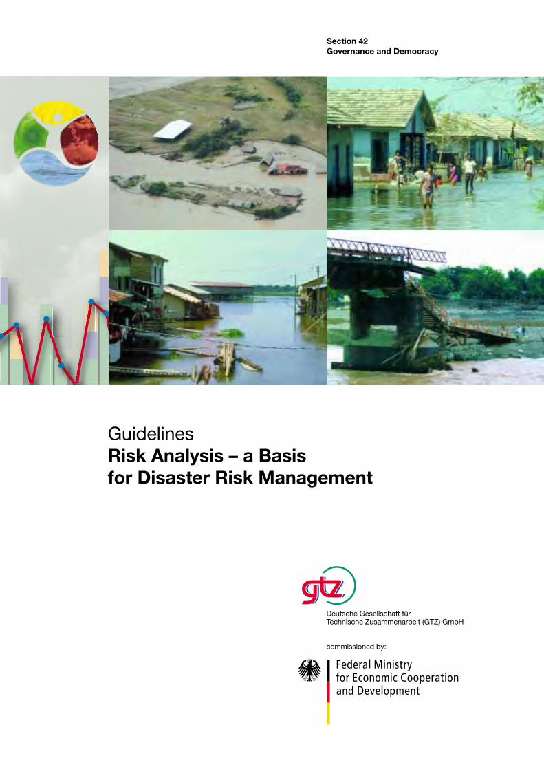
Section 42 Governance and Democracy Deutsche Gesellschaft für Technische Zusammenarbeit (GTZ) GmbH commissioned by: Guidelines Risk Analysis – a Basis for Disaster Risk Management
-
Upload
hoangkhanh -
Category
Documents
-
view
221 -
download
1
Transcript of Guidelines Risk Analysis – a Basis for Disaster Risk ... Gesellschaft für Technische...
Section 42Governance and Democracy
Deutsche Gesellschaft fürTechnische Zusammenarbeit (GTZ) GmbH
commissioned by:
GuidelinesRisk Analysis – a Basisfor Disaster Risk Management


Deutsche Gesellschaft für Technische Zusammenarbeit
(GTZ) GmbH
Guidelines
Risk Analysis –a Basis for DisasterRisk Management
Eschborn, June 2004
Authors:
Alois Kohler (Liu), MS (agronomics), specialising in
rural development, resource management, land use
planning and disaster risk management, freelance
appraiser since 2000, primarily for the GTZ.
A total of 25 years’ experience in development
cooperation, including 10 years working for the GTZ
in Latin America.
e-mail: [email protected] or [email protected]
Sebastian Jülich, studied at Bonn, MS (geography),
specialising in development economics and natural
disasters. From 2001, numerous appraiser commissions
for the GTZ.
e-mail: [email protected]
Lena Bloemertz, MS (geoecology), currently preparing
for her doctorate in social geography, focusing on
natural hazards and development. She has acquired
experience of development cooperation in the course
of a number of work experience assignments, and
worked for the GTZ as an appraiser in 2003.
e-mail: [email protected]
With increasing frequency, the developing countries and the people living there are
being affected by disasters. More and more often, development efforts are being
destroyed.The reason for this trend is their growing vulnerability, which in turn is the
result of economic and social development processes, such as the expansion of settle-
ments and agricultural land in risk areas. The economic and social consequences of
these disasters for the people in our partner countries last for years.
To break and,if possible,reverse this trend,international organisations,governments
and NGOs in the developing countries are increasingly upgrading the priority of disa-
ster risk management for policy,and taking concrete preventive measures to reduce the
risk to the population. For the GTZ, disaster risk management is an important aspect
of its work in Latin America, Africa and Asia. It is accordingly producing concepts,
methods and instruments for disaster risk reduction in these regions. One of the most
important instruments is risk analysis, as a basis for effective disaster risk management.
The BMZ commissioned the GTZ to produce the present guidelines.Their goal is to
help integrate risk analysis into projects and programmes in jeopardised regions, e.g.
rural development, promotion of local communities or sustainable resource conser-
vation. Equally important is the use of risk analysis in reconstruction programmes to
ensure sustainability in designing a fresh start,e.g.after a flood or an earthquake. In this
respect, these guidelines meet the goal of the German Federal government of embed-
ding disaster risk management in development cooperation as a cross-cutting respon-
sibility.
In the present publication the GTZ presents implementation-oriented concepts,
instruments and methods for risk analysis which have been tested in projects funded
by the BMZ and the German Foreign Office. It is part of GTZ services for disaster risk
management, and is aimed primarily at the staff of the GTZ and its partner experts, and
experts in national and international institutions and organisations.
We wish to thank particularly the authors Alois Kohler, Sebastian Jülich and Lena
Bloemertz for developing the concepts and instruments presented in these guidelines,
and Christina Bollin and Mario Donga at the GTZ for producing the present publi-
cation.We also wish to thank the staff of the GTZ, partner institutions and other orga-
nisations for their cooperation in reviewing experience and their suggestions.
Foreword
Bernd Hoffmann
Head of DivisionGovernance and Democracy
Thomas Schaef
Planning OfficerInternational Cooperation in
the Context of Conflicts and Disasters
The authors wish to thank Thomas Schaef (GTZ) for
coordinating the work and maintaining an ongoing dia-
logue, and all the projects and individuals who contri-
buted experience and ideas at the international work-
shops in Piura (Peru, 3 –5.6.2003) and Cochabamba
(Bolivia, 22–23.9.2003) which have enriched these
guidelines. In addition, the following projects in parti-
cular participated in the development of these guide-
lines by implementing and evaluating risk analysis in-
struments:Disaster risk management and reconstruction
– PAEN/El Niño,Piura,Peru (GTZ);disaster risk manage-
ment and food security in the water catchment area of
San Pedro, NP, Bolivia (GTZ); disaster risk management
and food security in Arequipa, Peru (GTZ); reconstruc-
tion and disaster risk management in Sofala Province,
Mozambique (GTZ); development-oriented reconstruc-
tion and reducing vulnerability to disaster in the Atlan-
tida Departement, Honduras (La MAMUCA, GTZ); inter-
institutional cooperation for disaster risk management
in municipal planning, Bolivia (FAM-Amdecruz, GTZ,
AA); local support for disaster risk management and risk
analysis, Nicaragua (ALARN-COSUDE).
We also wish to thank the following individuals,
whose ideas, comments and expert contributions en-
riched and even made possible the present document.
Christina Bollin, Alberto Aquino, Ralf Kaltofen, Claudia
Maier, Eberhard Goll, Elisabeth Mausolf, Wolfgang
Stiebens, Rolf Wachholtz, Wolfgang Weinmann, Rosa
Sanchez, Ali Neumann, Peter Asmussen and Mario
Donga.
The present publication contains the main part of
the risk analysis. A CD containing 11 extensive appen-
dices is available in German to interested users on
request from the sector project “Disaster Risk Manage-
ment in Development Cooperation” (GTZ Eschborn,
The appendices cover the following topics:
1) Remote sensing and geographical information
systems in disaster risk management;
2) The “Sustainable Livelihood Approach”
(SLA – analysis at household level);
3) ENSO – El Niño Southern Oscillation;
4) Soil and Water Assessment Tool (SWAT);
5) The NAXOS-Praedict early warning system for
flood protection;
6) Methods for recording erosion (USLE etc);
7) NOAA approaches (National Oceanic and
Atmospheric Administration);
8) Tasks and activities in carrying out a risk analysis;
9) Selected organisations and contact persons for
risk analysis;
10) Risk analysis – methods for assigning relative
values, using the example of landslides, PGRSAP-
GTZ-Wachholtz Survey Ltd, 2003;
11) Interactive CD-ROM “Digital information pool on
natural disasters and disaster risk management”.
The guidelines were started within the framework of
a BMZ-funded study and expert fund and completed
in the sector project “Disaster Risk Management in
Development Cooperation”.
We hope that our readers and users will find these
guidelines interesting and helpful, and we look forward
to your feedback.
The authors
6
Acknowledgements
List of abbreviations
1 Introduction
1.1 The approach
1.2 What and who is it for?
1.3 Some definitions
2 Growing disasters and new demands
on development cooperation
2.1 From emergency aid to prevention
2.2 Project types and linking short term
and long term measures
2.3 Disaster risk management as part of
other planning
3 The concept of disaster risk as the
product of hazard and vulnerability
3.1 The concept of disaster
3.2 The nature of risk
3.3 The elements of hazard and vulnerability
4 Disaster risk management: concept,
areas for action and components
4.1 Disaster risk management –
concept and areas for action
4.2 Disaster risk management and its
components
5 Risk analysis: concept, goal and
products
5.1 The concept of risk analysis
5.2 Risk analysis: goal and products
6 Elements in carrying out a risk analysis
6.1 Criteria for determining the methods
and instruments in applying risk analysis
6.2 Elements in implementation
7 Instruments and approaches in
risk analysis
7.1 Overview
7.2 Hazard and vulnerability analysis,
using floods as an example
7.3 Hazard and vulnerability analysis,
using drought as an example
7.4 Hazard and vulnerability analysis,
using erosion as an example
8 Outlook
9 Recommended literature on risk
analysis and disaster risk management
7
Contents
6
7
7
7
8
10
10
12
13
14
14
14
15
18
18
18
21
21
25
27
27
29
30
30
31
52
61
68
69
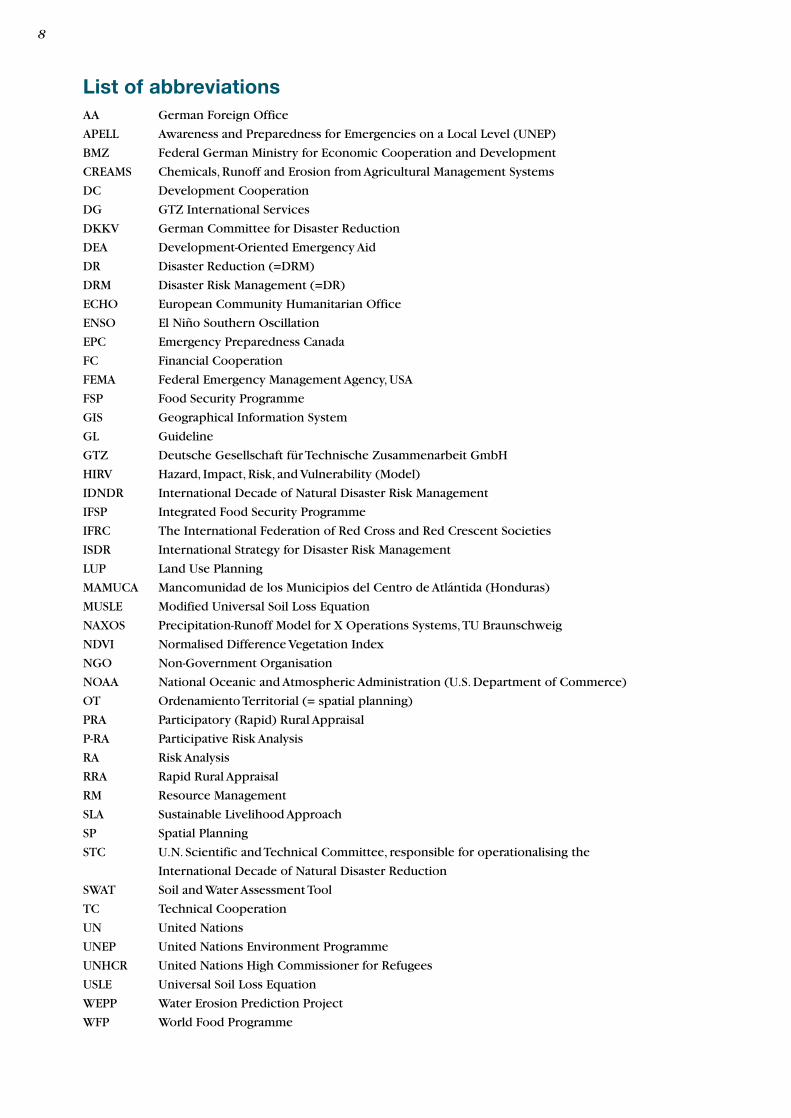
List of abbreviationsAA German Foreign Office
APELL Awareness and Preparedness for Emergencies on a Local Level (UNEP)
BMZ Federal German Ministry for Economic Cooperation and Development
CREAMS Chemicals, Runoff and Erosion from Agricultural Management Systems
DC Development Cooperation
DG GTZ International Services
DKKV German Committee for Disaster Reduction
DEA Development-Oriented Emergency Aid
DR Disaster Reduction (=DRM)
DRM Disaster Risk Management (=DR)
ECHO European Community Humanitarian Office
ENSO El Niño Southern Oscillation
EPC Emergency Preparedness Canada
FC Financial Cooperation
FEMA Federal Emergency Management Agency, USA
FSP Food Security Programme
GIS Geographical Information System
GL Guideline
GTZ Deutsche Gesellschaft für Technische Zusammenarbeit GmbH
HIRV Hazard, Impact, Risk, and Vulnerability (Model)
IDNDR International Decade of Natural Disaster Risk Management
IFSP Integrated Food Security Programme
IFRC The International Federation of Red Cross and Red Crescent Societies
ISDR International Strategy for Disaster Risk Management
LUP Land Use Planning
MAMUCA Mancomunidad de los Municipios del Centro de Atlántida (Honduras)
MUSLE Modified Universal Soil Loss Equation
NAXOS Precipitation-Runoff Model for X Operations Systems,TU Braunschweig
NDVI Normalised Difference Vegetation Index
NGO Non-Government Organisation
NOAA National Oceanic and Atmospheric Administration (U.S. Department of Commerce)
OT Ordenamiento Territorial (= spatial planning)
PRA Participatory (Rapid) Rural Appraisal
P-RA Participative Risk Analysis
RA Risk Analysis
RRA Rapid Rural Appraisal
RM Resource Management
SLA Sustainable Livelihood Approach
SP Spatial Planning
STC U.N. Scientific and Technical Committee, responsible for operationalising the
International Decade of Natural Disaster Reduction
SWAT Soil and Water Assessment Tool
TC Technical Cooperation
UN United Nations
UNEP United Nations Environment Programme
UNHCR United Nations High Commissioner for Refugees
USLE Universal Soil Loss Equation
WEPP Water Erosion Prediction Project
WFP World Food Programme
8
crete implementation. The present guidelines on risk
analysis were developed for this reason,and to meet the
needs of the projects of (German) development coope-
ration.
The guidelines are based on the GTZ working con-
cept “Disaster Risk Management”, which has been avail-
able at the GTZ since December 2001.
These guidelines on risk analysis became necessary as
a result of the new demands posed by the increasing
number of disasters and resulting increase and change
in requirements in DC. These requirements include
specifically
• more elaborate and complex coordination due to
the increase in number and diversity of donors and
organisations;
• closer links between humanitarian aid, emergency
aid, reconstruction and development (TC) and secu-
ring the transition from emergency aid to recon-
struction and TC;
• given the growing scarcity of resources, increasing
pressure to show that a) emergency aid measures
restore the conditions for sustainable development
and b) investment in disaster risk management leads
to reduced vulnerability.
1 Introduction
The present guidelines are based on cooperation with
staff at GTZ Eschborn, and particularly the section
“International cooperation in the context of conflicts
and disasters” and with various projects of bilateral
German development cooperation in partner countries
in Latin America, Africa and Asia. In addition, an exten-
sive body of literature in German, English and Spanish
was reviewed and consulted, together with relevant
documentation from projects,workshops and meetings.
In developing the methodology, we incorporated both
concrete experience from practice and the information
from our review of the literature.Technical Cooperation
(TC) projects also provided important feedback from
practice at the workshops in Piura (Peru,3–5.6.03) and
Cochabamba (Bolivia, 22–23.9.03)
The approaches, concepts, methods and termino-
logy for disaster risk management and risk analysis found
in the reports and other literature are very diverse, in
some cases contradictory1, mostly lacking in precision
and often very academic in their presentation. In the
case of risk analysis in particular there are virtually no
documents with clear presentations at the level of con-
1.1 The approach
1 For example, the name “risk maps” is applied to maps showing different information, and the same goes for hazard maps.
1.2 What and who is it for?
The GTZ has responded to these new requirements by
developing the concept of “development-oriented
emergency aid (DEA)” which includes and links the
components of emergency aid,rehabilitation and recon-
struction, disaster risk management and crisis preven-
tion, laying the basis for structural development (TC).
Methods and instruments are needed to make this
linkage possible. One of these basic instruments is risk
analysis, which lays the foundation for developing the
strategies for deploying the various components of
DEA. Risk analysis shows whether there is a need for
reconstruction and TC after a brief period of emergen-
cy aid, and if so, how these can be configured.
The guidelines are intended to be useful and appli-
cable in the case of not only emergency aid and huma-
nitarian aid,which generally have a planning horizon of
6–12 months, but also the other components of DEA,
such as reconstruction measures and food security pro-
grammes in the context of disasters.They are also inten-
ded to be useful for TC projects which are being im-
plemented in regions threatened by natural hazards or
which contain components of disaster risk manage-
ment.
These TC projects (rural development, community
promotion, resource management, etc) and projects
following the DEA concept have so far had different
experience with various approaches to disaster risk
management (DRM). Risk analysis as an element of
these is often treated as a secondary priority, or even
neglected altogether. Alternatively, it is developed and
carried out within a specific project, requiring exten-
sive inputs.
The context for the present guidelines is bilateral
and multilateral development cooperation which
assists and advices projects in disaster risk management
(DRM) and disaster response as well as projects in
various sectors with components of DRM. Due to their
economic situation and sociopolitical conditions, the
developing and transition countries do not have the
financial strength or knowledge to prepare appropri-
ately for individual hazards and plan and implement
fundamental social measures to reduce and cope with
disasters (early warning systems, protective structures,
disaster protection organisations, insurance systems).
These guidelines are also intended to provide assis-
tance where the basic data required for the use of
hi-tech models in geographical information systems
(GIS) is not available.This is generally the case in pro-
jects operating in the context of poverty, where there
are no qualified experts and institutions, but where it is
still necessary to develop solutions for the population
affected.
The use of risk analysis is intended to enhance the
importance and priority of disaster prevention and
preparedness and make them more effective, as a way
of reducing damage and losses from extreme natural
disasters and reducing the need for emergency aid.
A hazard is a natural physical phenomenon which can
lead to a loss of life or damage to objects, buildings
and the environment. The hazard is measured and
defined by its nature (type of hazard), location and
extent, scope and intensity (damage potential) and
its probability of occurrence, duration and frequency
(repetition cycles). Examples: floods, earthquakes,
droughts, landslides, etc.
Vulnerability expresses the level of possible loss or
injury or damage to humans, objects, buildings and the
environment which can result from the natural hazard.
Vulnerability expresses the susceptibility and predis-
position to be affected or suffer injury or damage.It also
captures people’s inadequate options or ability to pro-
tect themselves against possible damage or recover from
the consequences of natural phenomena without out-
side help. Vulnerability always relates to a concrete
hazard. It arises out of the interaction of social, eco-
nomic, physical and environmental factors.
The level of vulnerability of a society to a specific ex-
treme natural phenomenon (hazard) is determined by
the potential damage caused by the natural phenome-
non.
There is just one vulnerability, which depends on
and is influenced by various factors, and not specific
sectoral vulnerabilities, such as economic, political or
institutional vulnerability, as described in numerous
publications. In addition to these “specific vulnerabili-
ties”, the specialist literature also often uses the term
“ecological vulnerability”.This refers to the vulnera-
bility of the environment (soil, water). However, “eco-
logy”covers more than just the environment.Ecology in
these guidelines is used to refer to the science dealing
with the relationship between nature and society, and
not just one of these two components.
1 Introduction10
1.3 Some definitions
Vulnerability factors: vulnerability and its severity
depend on a range of factors. In these guidelines,
vulnerability factors are allocated to the following four
categories: physical, environmental, economic and
social. The vulnerability factors to be identified and
researched depend on the particular hazard type and
location. They are explained in detail in sections 3
and 7.
Risk is defined as the product of hazard and vul-
nerability (R=HxV), or – to put it another way – risk as
the probability of an encounter between a specific
hazard and an element vulnerable to this is interpre-
ted as the probability of occurrence of loss of life or
damage to objects,buildings and the environment as the
result of an extreme natural phenomenon with a speci-
fic strength or intensity.
Disaster risk management (DRM): the terms
disaster reduction (DR) and disaster risk manage-
ment (DRM) are used as synonyms in the present
guidelines. However, DRM is preferred, as this conveys
a stronger sense of direct local initiative. In addition to
risk analysis, DRM also includes prevention and pre-
paredness for disaster. By contrast, disaster management
(DM) consists of DRM as well as disaster response.
Risk analysis is used here as a synonym for risk
assessment. However, many authors and documents
distinguish between these. Where this is done, risk
assessment is taken as also including risk evaluation,
socioeconomic cost-benefit analysis, prioritisation of
measures,establishing acceptable risk levels,developing
scenarios and measures2. Risk analysis (RA) is used in
these guidelines to refer to a method of determining the
quantitative or qualitative degree of risk.The term “risk
analysis” has the underlying concept of “participative
risk analysis” (P-RA).This means that the affected tar-
get population are involved in the various stages of a risk
analysis, and adopt the DRM as their own.
2 From: ISDR (2002): Living with Risk:A global review of disaster reduction in-itiatives. Preliminary version July 2002, p.66
1 Introduction 11
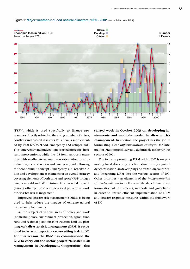
In development cooperation (DC), more and more
money is being spent on disaster and emergency aid, in
both absolute terms and as a share of DC financing.Given
the general shortage of funding, this is at the expense of
spending on Technical Cooperation (TC), which aims
at sustainable structural measures. This is a result on
the one hand of the increase in extreme natural events
and phenomena,primarily of climatic or meteorological
origin (such as floods, storms and droughts) and on the
other hand of the dramatic increase in vulnerability due
to population growth, weak institutions, poverty, and
inadequate and uncontrolled use of natural resources.
To a considerable extent, the increase in vulnera-
bility is due to the growth in poverty in many countries
and regions, which leads to settlements and productive
activities increasingly relocating to and expanding in
areas which are at risk (traditional flood areas,steep and
unstable hillsides, wet areas, forest areas with vulner-
able ecosystems, etc). Other causes are dysfunctional
disaster protection, missing or inaccurate precaution-
ary planning (risk analysis, disaster prevention) and a
lack of strategies for water catchment area management
and rural development.
The extensive neglect of rural development is one
of the most important reasons for the rapid and uncon-
trolled growth of urban population centres which are
particularly vulnerable to extreme natural events.
Disasters lead to increased poverty. In many hazard-
ous regions, there has been a dramatic rise in the num-
ber of starving people after natural disasters, e.g. in
Honduras and Nicaragua after Hurricane Mitch and in
El Salvador after the earthquake. The German Federal
Government and the GTZ are trying to counter this trend
towards growing demand for emergency aid through in-
creased efforts aimed primarily at strengthening disaster
prevention and preparedness. This includes improved
coordination and linkage between the various compo-
nents of DEA and with TC.However, emergency aid has
also been faced by changing demands in recent years as
a result of these developments. New coordination
mechanisms were needed to coordinate the large num-
ber of organisations involved in supplying aid. Planning
has to include the interfaces with other aid services and
must facilitate the transition to reconstruction and struc-
tural DC, to ensure that emergency aid has lasting posi-
tive effects. Another important quality criterion is the
contribution towards conflict reduction.
The German Federal Ministry for Economic Cooper-
ation and Development (BMZ) is responding to the
growing number of conflicts and disasters by redirect-
ing budget item 687083 “Food security programmes
2 Growing disasters and new demandson development cooperation
2.1 From emergency aidto prevention
3 Primarily used in the past to combat structural hazards to nutrition.
1950 1955 1960 1965 1970 1975 1980 1985 1990 1995 2000
70
60
50
40
30
20
10
0
14
12
10
8
6
4
2
0
Numberof Events
Economic loss in billion US-$(based on the year 2001)
StormFlooding
Others
(FSP)”, which is used specifically to finance pro-
grammes directly related to the rising number of crises,
conflicts and natural disasters.This item is supplement-
ed by item 69725 “Food, emergency and refugee aid”.
The “emergency aid budget item”is used more for short-
term interventions, while the ‘08 item supports meas-
ures with medium-term, multiyear orientation towards
reduction, reconstruction and emergency aid following
the “continuum” concept (emergency aid, reconstruc-
tion and development as elements of an overall strategy
covering elements of both time and space) FSP bridges
emergency aid and DC. In future, it is intended to use it
(among other purposes) in increased preventive work
for disaster risk management.
Improved disaster risk management (DRM) is being
used to help reduce the impacts of extreme natural
events and phenomena.
As the subject of various areas of policy and work
(domestic policy, environment protection, agriculture,
rural and regional planning,construction, land use plan-
ning, etc), disaster risk management (DRM) is recog-
nised today as an important cross-cutting task in DC.
For this reason the BMZ has commissioned the
GTZ to carry out the sector project “Disaster Risk
Management in Development Cooperation”: this
started work in October 2003 on developing in-
struments and methods needed in disaster risk
management. In addition, the project has the job of
formulating clear implementation strategies for inte-
grating DRM more closely and definitively in the various
sectors of DC.
The focus in promoting DRM within DC is on pro-
moting local disaster protection structures (as part of
decentralisation) in developing and transition countries,
and integrating DRM into the various sectors of DC.
Other priorities – as elements of the implementation
strategies referred to earlier – are the development and
formulation of instruments, methods and guidelines,
in order to ensure efficient implementation of DRM
and disaster response measures within the framework
of DC.
Figure 1: Major weather-induced natural disasters, 1950 – 2002 (source: Münchener Rück)
2 Growing disasters and new demands on development cooperation 13
Disasterresponse
Disaster riskmanagement
Sustainabledevelopment
TC/FC projectsup to 12 years
AAdisaster reduction
1 year
Food securityin the context of
conflicts and disasters(BMZ budget item 68708)
max. 6 years
Emergency and refugee aid(BMZ budget item 68725)
1 year
Creatingthe conditionsfor sustainabledevelopment
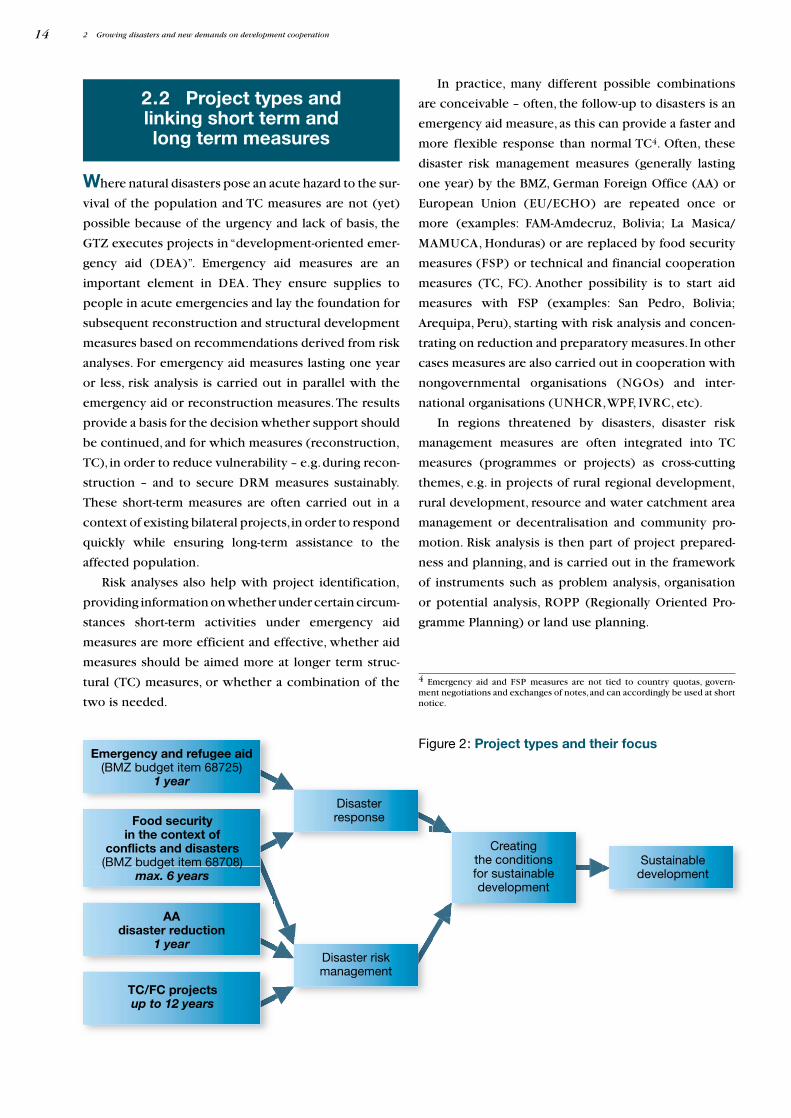
Where natural disasters pose an acute hazard to the sur-
vival of the population and TC measures are not (yet)
possible because of the urgency and lack of basis, the
GTZ executes projects in “development-oriented emer-
gency aid (DEA)”. Emergency aid measures are an
important element in DEA. They ensure supplies to
people in acute emergencies and lay the foundation for
subsequent reconstruction and structural development
measures based on recommendations derived from risk
analyses. For emergency aid measures lasting one year
or less, risk analysis is carried out in parallel with the
emergency aid or reconstruction measures.The results
provide a basis for the decision whether support should
be continued, and for which measures (reconstruction,
TC), in order to reduce vulnerability – e.g.during recon-
struction – and to secure DRM measures sustainably.
These short-term measures are often carried out in a
context of existing bilateral projects,in order to respond
quickly while ensuring long-term assistance to the
affected population.
Risk analyses also help with project identification,
providing information on whether under certain circum-
stances short-term activities under emergency aid
measures are more efficient and effective, whether aid
measures should be aimed more at longer term struc-
tural (TC) measures, or whether a combination of the
two is needed.
In practice, many different possible combinations
are conceivable – often, the follow-up to disasters is an
emergency aid measure, as this can provide a faster and
more flexible response than normal TC4. Often, these
disaster risk management measures (generally lasting
one year) by the BMZ, German Foreign Office (AA) or
European Union (EU/ECHO) are repeated once or
more (examples: FAM-Amdecruz, Bolivia; La Masica/
MAMUCA, Honduras) or are replaced by food security
measures (FSP) or technical and financial cooperation
measures (TC, FC). Another possibility is to start aid
measures with FSP (examples: San Pedro, Bolivia;
Arequipa, Peru), starting with risk analysis and concen-
trating on reduction and preparatory measures. In other
cases measures are also carried out in cooperation with
nongovernmental organisations (NGOs) and inter-
national organisations (UNHCR,WPF, IVRC, etc).
In regions threatened by disasters, disaster risk
management measures are often integrated into TC
measures (programmes or projects) as cross-cutting
themes, e.g. in projects of rural regional development,
rural development, resource and water catchment area
management or decentralisation and community pro-
motion. Risk analysis is then part of project prepared-
ness and planning, and is carried out in the framework
of instruments such as problem analysis, organisation
or potential analysis, ROPP (Regionally Oriented Pro-
gramme Planning) or land use planning.
2 Growing disasters and new demands on development cooperation
2.2 Project types andlinking short term andlong term measures
Figure 2: Project types and their focus
14
4 Emergency aid and FSP measures are not tied to country quotas, govern-ment negotiations and exchanges of notes,and can accordingly be used at short notice.
Depending on the constellation and the course of
the project, risk analysis can also be carried out in such
projects during other phases of the project cycle. A
distinction needs to be made here between normal
TC, where projects can have a duration up to c. twelve
years,FSP with terms of at most six years,and the emer-
gency aid or disaster risk management projects (BMZ,
AA) referred to above, which normally have terms of a
year or less. In the latter case, there is no preparatory
phase, and the conditions and time for a detailed risk
analysis are lacking. In this case, risk analysis must be
seen as a rough estimate, with the analysis focusing on
general conditions in order to arrive at an assessment of
the value, usefulness and type of follow-up measures.
Development oriented emergency aid (DEA)
with its interlinked components of emergency aid,
rehabilitation and reconstruction, disaster risk manage-
ment and crisis prevention is intended (among other
things) to prepare the way for structural development
The projects supported by the GTZ are the result of
processes of negotiation and the expression of both
international and binational agreements and national
policies.Since “Rio 92”the Federal Republic of Germany
has been just as committed to the paradigm of sustain-
able development as the governments of the partner
countries (Rio Declaration, Agenda 21, Convention on
Biological Diversity, Framework Convention on Climate
Change) which the German Federal Government coope-
rates with.
One of the GTZ’s goals is accordingly “to promote
the formation of viable partnerships for sustainable
development by supporting learning and negotiations
processes which lead to a balance between the eco-
nomic, social and ecological dimensions of develop-
ment in the interests of present and future genera-
tions”5.
The specific anchoring of the projects supported by
the GTZ a) in the paradigm of sustainable development
and the development policy principles of the German
Federal Government, b) in the development efforts of
the partner countries, and c) in the mostly short-term
expectations and needs of the target groups leads to a
situation where the diverse interests, necessities and
needs have to be coordinated and negotiated.This pro-
cess of negotiation is often charged with conflict, and
risk analysis is the only way to provide competent sup-
port and advice.Risk analysis also supplies a foundation
for a) detailed formulation of an efficient DRM and b)
concrete linkage of the DRM with other planning or
integration into a national development strategy. The
DRM must be or become an element of a national
development strategy in order to be successful and con-
tribute to sustainable development.
2 Growing disasters and new demands on development cooperation
5 From: Burger/Happel: “Das Leitbild nachhaltiger Entwicklung – handlungs-leitende Orientierung der GTZ?“ Diskussionspapier 3/97.
(TC). Risk analyses are essential in making possible
this interlinkage and also in creating a bridge to struc-
tural TC.Risk analyses are a necessary basis for develop-
ing adequate and efficient strategies for implementing
the various components of DEA and moving on from
both emergency aid and reconstruction measures to less
vulnerable and more sustainable development meas-
ures. Risk analysis can show whether reconstruction
and TC are useful and necessary after a brief period of
emergency aid.
The nature and scope of risk analyses and the meas-
ures based on these can vary extensively, depending on
the hazard and whether they are concerned with the
national, regional, village or household level.
Typical phases in a disaster:
emergency aid (medical services, tents, water,
waste water disposal, medication) ➜ food aid ➜
rehabilitation and reconstruction based on risk
analysis ➜ disaster risk management (risk analy-
sis, prevention, spatial planning and prepared-
ness) ➜ rural regional development, promotion
of agriculture and employment, community
development and decentralisation.
2.3 Disaster riskmanagement as part of
other planning
15
Natural disasters are the result of the impact of an
extreme natural event on people and their vulnerable
goods and infrastructure, and cause loss of life and
damage to goods and the environment. A disaster is the
disruption of the functioning of a society to an extent
which exceeds the ability of the society to cope with it
from its own resources. The extent of the disaster
depends on both the intensity of the event and the
degree of vulnerability of the society6. A natural disaster
always consists of two elements,an (external) event (the
hazard) and the impacts of this hazard on a vulnerable
social group exposed to this hazard.
A powerful earthquake in an unpopulated area is not
a disaster,while a weak earthquake which hits an urban
area with buildings not constructed to withstand earth-
quakes, can cause great misery. Extreme natural events
only become disasters if they impact vulnerable people,
who often expose themselves to natural hazards through
carelessness or poverty, or who contribute to or aggra-
vate the events by intervening in nature.
Although reducing the risk of disaster can be done
by both restricting the hazard and reducing vulnera-
bility, DC mainly tries to reduce vulnerability, since
reducing the hazard is usually very difficult or even im-
possible.Vulnerability, by contrast, is easier to influence
by strengthening human response,planning and protec-
tive capabilities.
Disasters can be seen differently in other cultures.
Whether those affected see an event as a risk or as a
disaster, or whether they assess the risk as high or low
depends on the value system they feel bound by.
Perception of risk – or, more accurately, lack of percep-
tion of risk – is the most important factor in vulnera-
bility.
3 The concept of disaster riskas the product of hazard and vulnerability
3.1 The concept ofdisaster
6 From: BMZ Spezial Nr. 082/Juni ’97: Entwicklungspolitik zur Vorbeugung undBewältigung von Katastrophen und Konflikten – Konzeptionelle Aspekte undderen entwicklungspolitische Implikationen.
3.2 The nature of risk
Risks have always been part of daily life for humans.
Life without risk is neither possible nor conceivable.
However, both the level of acceptance and the percep-
tion of risk varies from one individual to another. One
person will take a sharp bend at 50 km/h, another at
80 km/h,depending on their assessment of risk.Percep-
tion also varies between regions, societies and cultures.
For example, there are countries who support nuclear
power plants without reservation, while others see the
risk as too great.
There is no universally valid definition of risk, pre-
cisely because perceptions differ between individuals
result in
triggers
x
Hazard
Risk
Vulnerability
and cultures. In the context of disaster risk manage-
ment, the following definition has been “agreed”:
Risk is the probability of a harmful occurrence
with a specific force at a specific location and at a
specific time. Risk relates to humans or objects at
risk from natural events.
To perceive, understand and assess risk requires ex-
perience with or knowledge about risks, i.e.experience
of something in the past.
Risk is something which has not happened yet,
something which is projected into the future. If a risk is
perceived as too great, there are two possibilities: elimi-
nate the risk, or reduce it as far as possible.
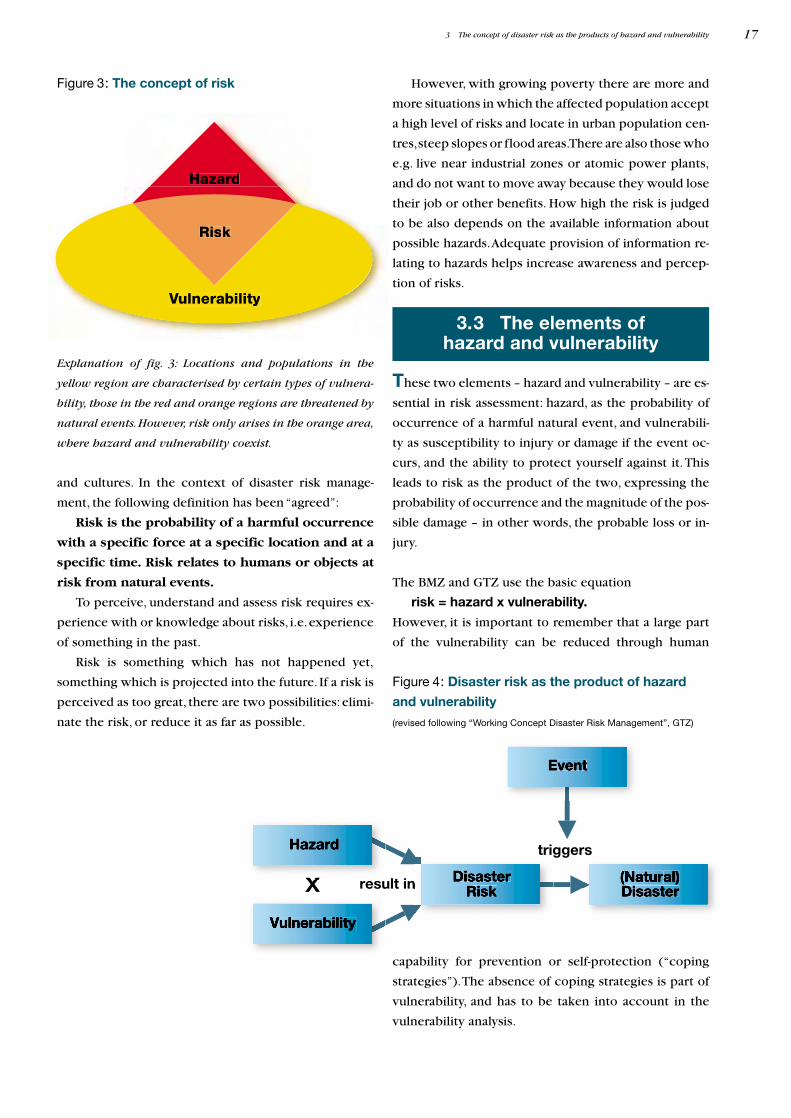
These two elements – hazard and vulnerability – are es-
sential in risk assessment: hazard, as the probability of
occurrence of a harmful natural event, and vulnerabili-
ty as susceptibility to injury or damage if the event oc-
curs, and the ability to protect yourself against it.This
leads to risk as the product of the two, expressing the
probability of occurrence and the magnitude of the pos-
sible damage – in other words, the probable loss or in-
jury.
The BMZ and GTZ use the basic equation
risk = hazard x vulnerability.
However, it is important to remember that a large part
of the vulnerability can be reduced through human
3 The concept of disaster risk as the products of hazard and vulnerability
Figure 3: The concept of risk
Explanation of fig. 3: Locations and populations in the
yellow region are characterised by certain types of vulnera-
bility, those in the red and orange regions are threatened by
natural events.However, risk only arises in the orange area,
where hazard and vulnerability coexist.
3.3 The elements ofhazard and vulnerability
Figure 4: Disaster risk as the product of hazard
and vulnerability
(revised following “Working Concept Disaster Risk Management”, GTZ)
capability for prevention or self-protection (“coping
strategies”).The absence of coping strategies is part of
vulnerability, and has to be taken into account in the
vulnerability analysis.
17
However, with growing poverty there are more and
more situations in which the affected population accept
a high level of risks and locate in urban population cen-
tres,steep slopes or flood areas.There are also those who
e.g. live near industrial zones or atomic power plants,
and do not want to move away because they would lose
their job or other benefits. How high the risk is judged
to be also depends on the available information about
possible hazards.Adequate provision of information re-
lating to hazards helps increase awareness and percep-
tion of risks.
Hazard and vulnerability must be simultaneously
present at the same location to give rise to risk, which
then becomes a disaster if the event actually occurs. A
society may be vulnerable to floods, but not to earth-
quakes (and vice versa).Vulnerability can only be iden-
tified and studied with reference to a concrete hazard.
Vulnerability to a specific type of hazard varies,depend-
ing on the sector and context: for example, in housing
areas, vulnerability arises out of the poor quality of
buildings and basic infrastructure, in health it arises out
of a lack of reserves of medication and first aid equip-
ment, in economic activities like agriculture it arises out
of a shortage of stockpiles, etc.
The vulnerability of a population or an ecosystem
involves very different and often interdependent fac-
tors, which have to be taken into account in deter-
mining the vulnerability of a family, a village or a coun-
try. It is like a spider web in which physical factors are
linked to economic, cultural, political, institutional,
ecological and other factors.
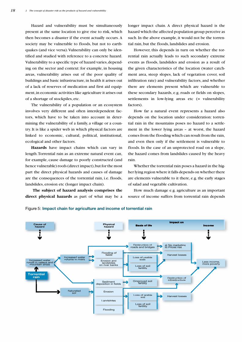
Hazards have impact chains which can vary in
length.Torrential rain as an extreme natural event can,
for example, cause damage to poorly constructed (and
hence vulnerable) roofs (direct impact),but for the most
part the direct physical hazards and causes of damage
are the consequences of the torrential rain, i.e. floods,
landslides, erosion etc (longer impact chain).
The subject of hazard analysis comprises the
direct physical hazards as part of what may be a
longer impact chain. A direct physical hazard is the
hazard which the affected population group perceive as
such. In the above example, it would not be the torren-
tial rain, but the floods, landslides and erosion.
However, this depends in turn on whether the tor-
rential rain actually leads to such secondary extreme
events as floods, landslides and erosion as a result of
the given characteristics of the location (water catch-
ment area, steep slopes, lack of vegetation cover, soil
infiltration rate) and vulnerability factors, and whether
there are elements present which are vulnerable to
these secondary hazards, e.g. roads or fields on slopes,
settlements in low-lying areas etc (= vulnerability
factors).
How far a natural event represents a hazard also
depends on the location under consideration: torren-
tial rain in the mountains poses no hazard to a settle-
ment in the lower lying areas – at worst, the hazard
comes from the flooding which can result from the rain,
and even then only if the settlement is vulnerable to
floods. In the case of an unprotected road on a slope,
the hazard comes from landslides caused by the heavy
rain.
Whether the torrential rain poses a hazard in the hig-
her lying region where it falls depends on whether there
are elements vulnerable to it there, e.g. the early stages
of salad and vegetable cultivation.
How much damage e.g. agriculture as an important
source of income suffers from torrential rain depends
3 The concept of disaster risk as the products of hazard and vulnerability18
Increased watervolume in rivers
Erosion
Less income,more poverty
Increased waterrunoff in valleys and
mountain areasy
a) No marketingb)))
Prices rise
Harvest losses
Loss of soilfertility
Destruction ofroads and bridges
Sedimentdeposition in fields
Landslides
Harvest losses
Destruction ofinfrastructure
Physicalhazard
Cause ofhazard
Flooding offields
g
Erosion andlandslides
on river banks
Loss of arablesoil
Flooding
Loss of soilfertility
Loss of usablesoils
Omproved soilfertilitypp
Saturatedsoil
Torrentialrain
Figure 5: Impact chain for agriculture and income of torrential rain
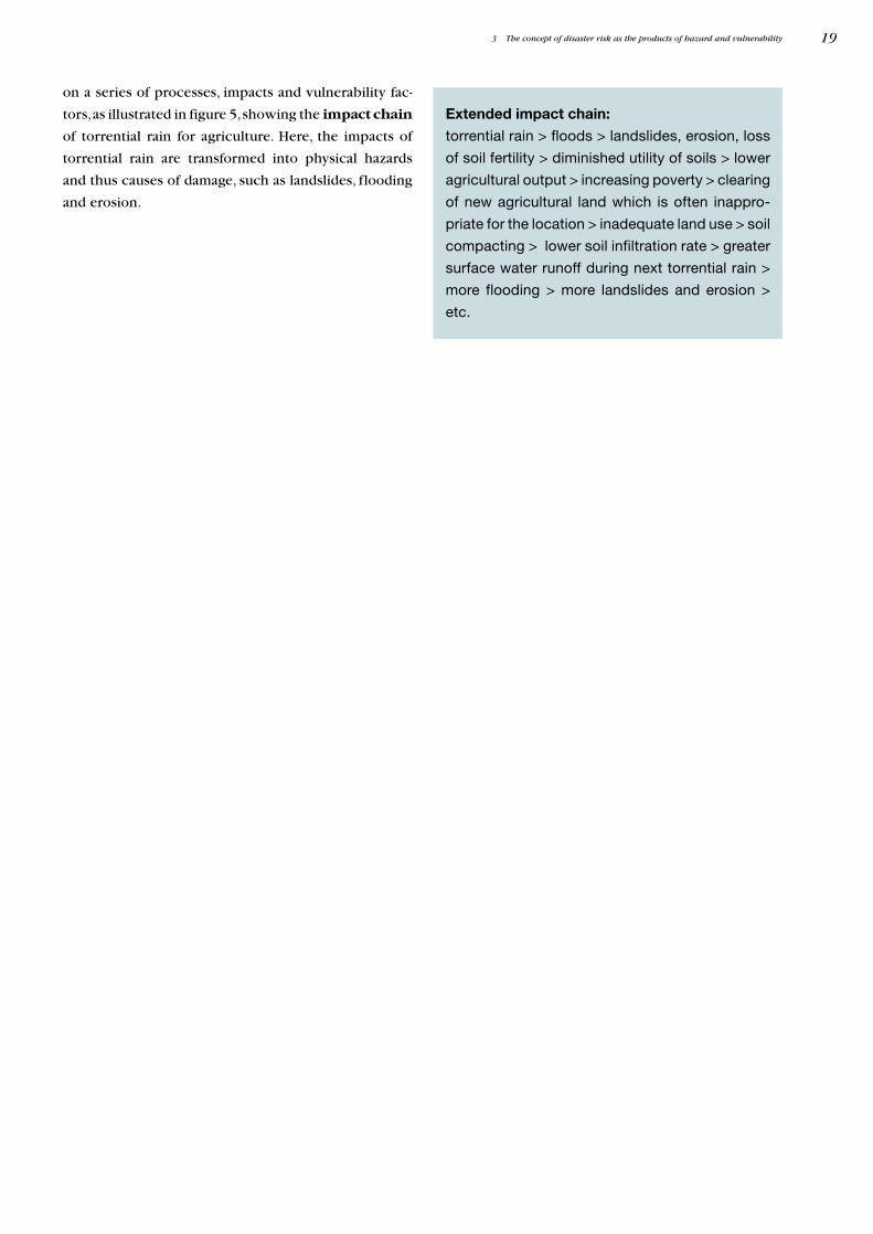
on a series of processes, impacts and vulnerability fac-
tors,as illustrated in figure 5,showing the impact chain
of torrential rain for agriculture. Here, the impacts of
torrential rain are transformed into physical hazards
and thus causes of damage, such as landslides, flooding
and erosion.
3 The concept of disaster risk as the products of hazard and vulnerability 19
Extended impact chain:
torrential rain > floods > landslides, erosion, loss
of soil fertility > diminished utility of soils > lower
agricultural output > increasing poverty > clearing
of new agricultural land which is often inappro-
priate for the location > inadequate land use > soil
compacting > lower soil infiltration rate > greater
surface water runoff during next torrential rain >
more flooding > more landslides and erosion >
etc.
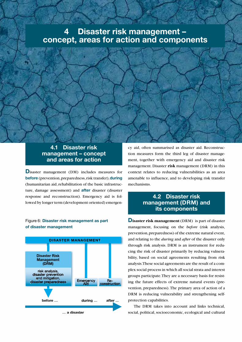
Disaster management (DM) includes measures for
before (prevention,preparedness,risk transfer),during
(humanitarian aid, rehabilitation of the basic infrastruc-
ture, damage assessment) and after disaster (disaster
response and reconstruction). Emergency aid is fol-
lowed by longer term (development oriented) emergen-
4 Disaster risk management –concept, areas for action and components
4.1 Disaster riskmanagement – concept
and areas for action
DISASTER MANAGEMENT
… a disaster
before … during … after …
Disaster RiskManagement
(DRM)
Figure 6: Disaster risk management as part
of disaster management
cy aid, often summarised as disaster aid. Reconstruc-
tion measures form the third leg of disaster manage-
ment, together with emergency aid and disaster risk
management. Disaster risk management (DRM) in this
context relates to reducing vulnerabilities as an area
amenable to influence, and to developing risk transfer
mechanisms.
4.2 Disaster riskmanagement (DRM) and
its components
Disaster risk management (DRM) is part of disaster
management, focusing on the before (risk analysis,
prevention,preparedness) of the extreme natural event,
and relating to the during and after of the disaster only
through risk analysis. DRM is an instrument for redu-
cing the risk of disaster primarily by reducing vulnera-
bility, based on social agreements resulting from risk
analysis.These social agreements are the result of a com-
plex social process in which all social strata and interest
groups participate.They are a necessary basis for resist-
ing the future effects of extreme natural events (pre-
vention, preparedness). The primary area of action of a
DRM is reducing vulnerability and strengthening self-
protection capabilities.
The DRM takes into account and links technical,
social, political, socioeconomic, ecological and cultural
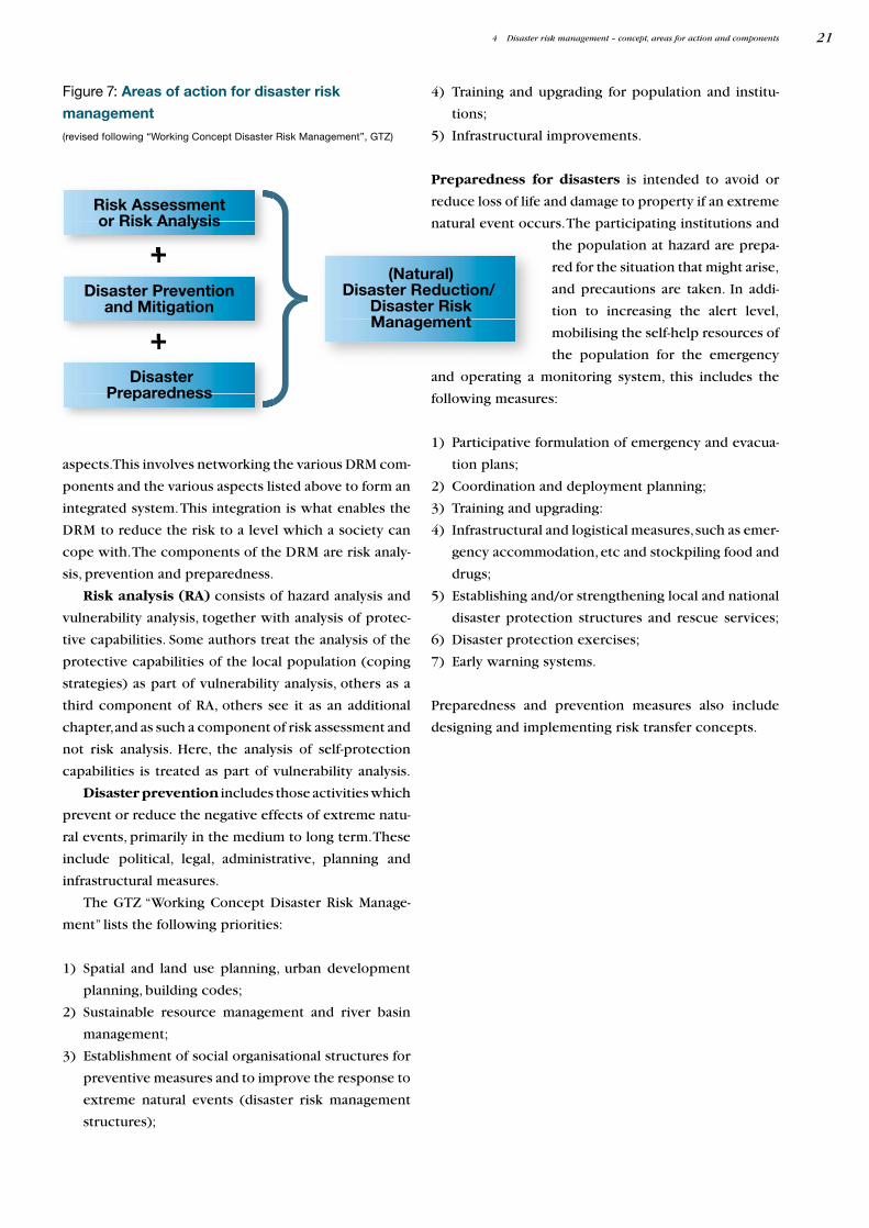
Risk Assessmentor Risk Analysis
Disaster Preventionand Mitigation
(Natural)Disaster Reduction/
Disaster RiskManagement
DisasterPreparedness
+
+
4) Training and upgrading for population and institu-
tions;
5) Infrastructural improvements.
Preparedness for disasters is intended to avoid or
reduce loss of life and damage to property if an extreme
natural event occurs.The participating institutions and
the population at hazard are prepa-
red for the situation that might arise,
and precautions are taken. In addi-
tion to increasing the alert level,
mobilising the self-help resources of
the population for the emergency
and operating a monitoring system, this includes the
following measures:
1) Participative formulation of emergency and evacua-
tion plans;
2) Coordination and deployment planning;
3) Training and upgrading:
4) Infrastructural and logistical measures,such as emer-
gency accommodation, etc and stockpiling food and
drugs;
5) Establishing and/or strengthening local and national
disaster protection structures and rescue services;
6) Disaster protection exercises;
7) Early warning systems.
Preparedness and prevention measures also include
designing and implementing risk transfer concepts.
4 Disaster risk management – concept, areas for action and components 21
aspects.This involves networking the various DRM com-
ponents and the various aspects listed above to form an
integrated system.This integration is what enables the
DRM to reduce the risk to a level which a society can
cope with.The components of the DRM are risk analy-
sis, prevention and preparedness.
Risk analysis (RA) consists of hazard analysis and
vulnerability analysis, together with analysis of protec-
tive capabilities. Some authors treat the analysis of the
protective capabilities of the local population (coping
strategies) as part of vulnerability analysis, others as a
third component of RA, others see it as an additional
chapter,and as such a component of risk assessment and
not risk analysis. Here, the analysis of self-protection
capabilities is treated as part of vulnerability analysis.
Disaster prevention includes those activities which
prevent or reduce the negative effects of extreme natu-
ral events, primarily in the medium to long term.These
include political, legal, administrative, planning and
infrastructural measures.
The GTZ “Working Concept Disaster Risk Manage-
ment” lists the following priorities:
1) Spatial and land use planning, urban development
planning, building codes;
2) Sustainable resource management and river basin
management;
3) Establishment of social organisational structures for
preventive measures and to improve the response to
extreme natural events (disaster risk management
structures);
Figure 7: Areas of action for disaster risk
management
(revised following “Working Concept Disaster Risk Management”, GTZ)
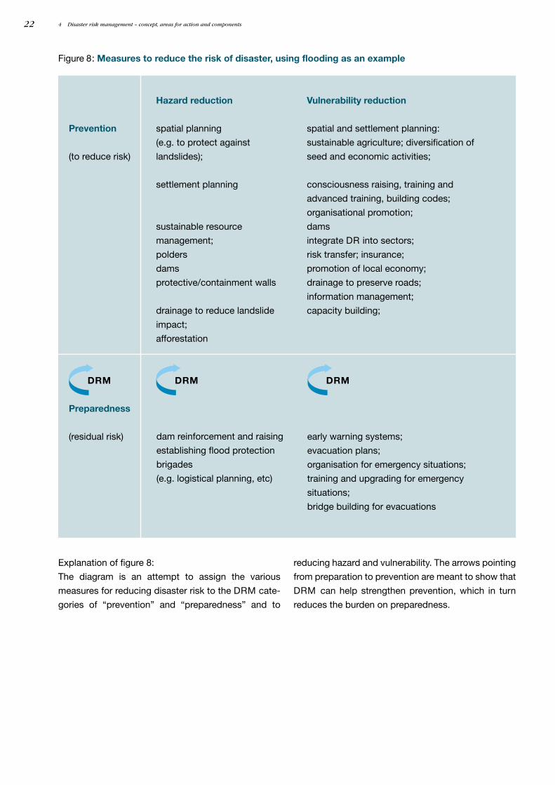
4 Disaster risk management – concept, areas for action and components22
DRM DRM DRM
Explanation of figure 8:
The diagram is an attempt to assign the various
measures for reducing disaster risk to the DRM cate-
gories of “prevention” and “preparedness” and to
Figure 8: Measures to reduce the risk of disaster, using flooding as an example
reducing hazard and vulnerability. The arrows pointing
from preparation to prevention are meant to show that
DRM can help strengthen prevention, which in turn
reduces the burden on preparedness.
Preparedness
(residual risk)
Prevention
(to reduce risk)
Vulnerability reduction
spatial and settlement planning:
sustainable agriculture; diversification of
seed and economic activities;
consciousness raising, training and
advanced training, building codes;
organisational promotion;
dams
integrate DR into sectors;
risk transfer; insurance;
promotion of local economy;
drainage to preserve roads;
information management;
capacity building;
Hazard reduction
spatial planning
(e.g. to protect against
landslides);
settlement planning
sustainable resource
management;
polders
dams
protective/containment walls
drainage to reduce landslide
impact;
afforestation
early warning systems;
evacuation plans;
organisation for emergency situations;
training and upgrading for emergency
situations;
bridge building for evacuations
dam reinforcement and raising
establishing flood protection
brigades
(e.g. logistical planning, etc)
Besides nature as the cause of disasters, increasing
attention is being paid to analysing the role of societies,
their mode of production and living, and their develop-
ment model as possible causes, and integrating the
results of this analysis into the various protective strate-
gies. In most parts of the world, disasters are no longer
accepted simply as acts of god or nature.This means that
vulnerability is increasingly understood as the result of
economic and social development processes, which
needs to be documented and reduced on the basis of
comprehensive analysis. Risk analysis is a basic instru-
ment of disaster risk management which is used to study
the factors of disaster risk and provides the basis for
planning and implementing measures to reduce risks
and impacts of disasters.
5 Risk analysis:concept, goal and products
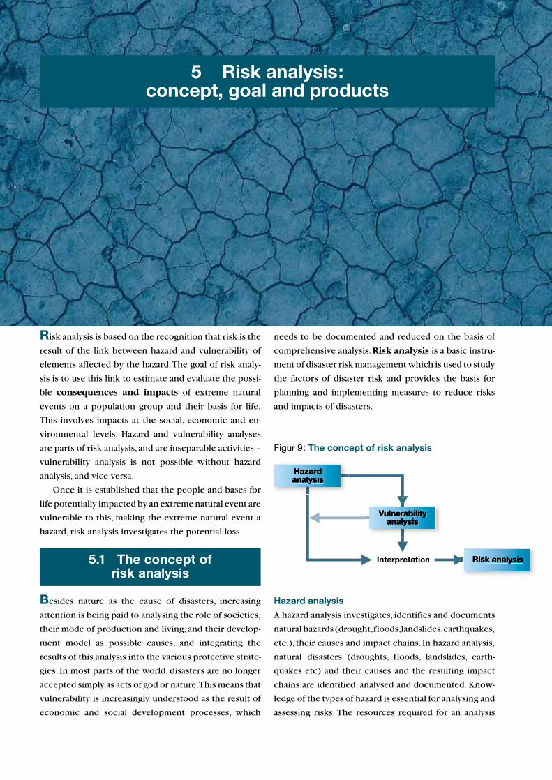
Risk analysis is based on the recognition that risk is the
result of the link between hazard and vulnerability of
elements affected by the hazard.The goal of risk analy-
sis is to use this link to estimate and evaluate the possi-
ble consequences and impacts of extreme natural
events on a population group and their basis for life.
This involves impacts at the social, economic and en-
vironmental levels. Hazard and vulnerability analyses
are parts of risk analysis, and are inseparable activities –
vulnerability analysis is not possible without hazard
analysis, and vice versa.
Once it is established that the people and bases for
life potentially impacted by an extreme natural event are
vulnerable to this, making the extreme natural event a
hazard, risk analysis investigates the potential loss.
5.1 The concept ofrisk analysis
Interpretation
Figur 9: The concept of risk analysis
Hazard analysis
A hazard analysis investigates, identifies and documents
natural hazards (drought,floods,landslides,earthquakes,
etc.), their causes and impact chains. In hazard analysis,
natural disasters (droughts, floods, landslides, earth-
quakes etc) and their causes and the resulting impact
chains are identified, analysed and documented. Know-
ledge of the types of hazard is essential for analysing and
assessing risks. The resources required for an analysis
extreme natural eventas hazard
gives rise to potentiallydamaging impacts
on
vulnerablepeople and their
basis of life
Hazard analysis investigates theextreme natural event, its characteristics,
its force, its potential for destruction and itslikelihood of occurrence.
Vulnerability analysis investigatesthe vulnerability of people and their basis
of life to the extreme natural eventidentified as a hazard.
The information from thesetwo analytical steps is usedto derive and evaluate the
probable damage.
depend on the situation.A simple analysis with modest
data input may be sufficient, or comprehensive inves-
tigations and elaborate studies may be
required to document hazard potentials.
To be able to estimate and evaluate the
degree of risk and the characteristics and
scale of possible loss from extreme natu-
ral events, it is necessary not only to esti-
mate the probability of occurrence but
also to investigate the force and duration
of the event. However, before this de-
tailed study it is necessary to establish
how far population groups and their
bases for life are potentially affected by
the event, i.e.how susceptible they are to the event and
how vulnerable they are to this hazard. If there are no
vulnerable populations or elements at the site of the
hazard, no hazard analysis is required, as in this case the
extreme natural event does not constitute a hazard.
These are the first steps in vulnerability analysis,and they
are needed before any detailed hazard analysis. Hazard
analysis is not a linear sequence of analytical steps relat-
ing to the hazard: it is constantly being interrupted by
steps in the vulnerability analysis, and supplemented by
the learning loops and results generated by this. This
leads to the procedure presented in figure 10.
The most important tasks and steps in hazard
analysis are:
1) The first stage in hazard analysis is to identify the
types of hazards. There are many ways to classify
hazard types, e.g. natural events occurring suddenly
or gradually, of an atmospheric, seismic, geological,
volcanic, biological and hydrological nature7 while
others summarise mass movements under the
heading of “geomorphological hazards”8. In these
guidelines, we use the classification shown in the
box below.
5 Risk analysis: concept, goal and products24
Figure 10: Assessment of impacts as the goal
of risk analysis
Main hazard types
A. Meteorological causes and origins
a) Floods caused by torrential rain and tropical storms
b) Storms and torrential rain > damage caused by storms, e.g. damage caused by tropical storms,
tornados and cyclones, hurricanes and tidal bores
c) Droughts have a particularly high damage potential if they cause extensive crop destruction and
famine or forest/bush fires
d) Hail and frost, if they lead to extensive crop destruction; lightning
e) Mass movements (e.g. landslides as a result of heavy and intensive rainfall) caused among other
things by 1) flooding in mountainous regions 2) heavy and intensive rain 3) rivers changing courses
f) Erosion, soil degradation caused by water and wind
g) Forest fires
B. Geological causes
h) Earthquakes and the secondary consequences such as tsunamis, tidal waves and mass movements
i) Volcanoes and the secondary consequences such as lava and mudflows
j) Mass movements caused by large-scale tectonic movements, slow mountain building and shifting.
The resultant changes to the angles of slopes can cause mass movements
C. Other
k) Epidemics, animal and plant diseases and pests
2) Depending on the types of hazard identified, the
process may need to be continued on a separate basis
for each type of hazard or group of hazard types.
Earthquakes, for example, require different instru-
ments and specialisations for analysis than e.g. land-
slides or floods.The analytical methodology must be
adapted for the hazard types and data available.
3) Identification and characterisation of hazard prone
locations.
4) Identification and determination of the probabilities
of occurrence on an ordinal scale (high – medium –
low).
5) Estimate or calculate the scale (strength,magnitude)
of the hazardous event, also on an ordinal scale.
6) Identify the factors influencing the hazards, e.g.
climatic change9, environmental destruction and
resource degradation, major infrastructural facilities
such as dams etc.
In the case of hydrometeorological hazards, there is a
close connection between weather and floods. The
weather determines the precipitation, which in turn
determines the runoff of the waters. Floods are deter-
mined by the specific characteristics of the catchment
area, and also by regional climatic factors. If these
climatic factors change, the vegetation also changes,
which modifies the runoff behaviour of the waters and
ultimately the scale of flooding.
Hazard analysis describes and assesses the proba-
bility of occurrence of an extreme natural event at a
specific place, at a specific time, and with a specific
intensity and duration, for a vulnerable population and
their vulnerable basis for life. It describes and evaluates
the degree to which the population, animals, structures
and goods would be at risk.10
Analysis of vulnerability11 and self-protection
capability
Vulnerability analysis studies the ability of a system (or
element) to withstand, avoid, neutralise or absorb the
impacts of hazardous natural events.
Before starting an analysis of the vulnerability of a
population group and its bases for living, the extreme
natural events and the locations they threaten must be
identified and studied.Without extreme natural events
as a hazard,there are no vulnerable elements,and hence
no hazard. Conversely, without threatened locations
with vulnerable elements, there is no risk,and hence no
need for either hazard or vulnerability analysis.
The vulnerability of a group of people or region is
inseparably linked to the social, cultural and economic
processes developing there and the agricultural and eco-
logical transformation of the region.Vulnerabilities are
created, they are the product of social development or
faulty development; they reflect deficits, shortages or
disruptions within social development.
Vulnerability is assessed by the potential loss resul-
ting from a natural event. It expresses the degree of
possible loss or damage to an element threatened by
a natural event of specific force. Damage can be to the
population (life, health, wellbeing), material assets
(buildings, infrastructure) or natural assets (woods,
forest, agricultural land).
The most important tasks and steps in vulnerabi-
lity analysis are:
1) Identification of potentially vulnerable individuals or
elements (e.g. agricultural production, buildings,
health, agricultural land and waters). In this, basic
data is collected on population (age, density, gender,
ethnic structure, socioeconomic status), location
(buildings, important facilities such as schools, hos-
pitals, emergency centres, environment, economy,
structures, history), self-protection capability in
terms of capacities for disaster preparedness – emer-
gency response capability, training, prevention pro-
gramme, early warning systems12.
2) Identification and analysis of factors influencing or
resulting in vulnerability = vulnerability factors for
5 Risk analysis: concept, goal and products 25
7 Guidelines “Katastrophenvorsorge und Ländliche Entwicklung”, GTZ 2002(draft)8 Zschau, J., A. N. Küppers (2003) “Early Warning Systems for Natural DisasterReduction”,Hans Kienholz “Early Warning Systems related to mountain hazards”,p. 556.9 Climatic data studies for 1961–1990 in Switzerland, for example,showed a risein temperature of just under one degree. Even if this period is too short for reliable interpretation of secular climatic changes, we can nevertheless expecta general warming with more extremely hot days and fewer extremely cold days.This warming reinforces the hydrological cycle, and various models indicatemore intensive rainfall and more extreme events involving rain. The GermanFederal Government’s Council of Scientific Advisers on Climate (1996) expectsa rise in sea level in German coastal regions of c.1 m by the end of the century,caused by global climate change.Worldwide, c.15% of the world population isthreatened by a rise in sea level. However, overall the increase in strength andfrequency of extreme events is seen as more serious.10 Hazard analysis is defined as follows in ISDR’s “Living with Risk”:”Identification, studies and monitoring of any hazard to determine its potential,origin, characteristics and behaviour”.
11 Vulnerability or susceptibility is understood here as possible damage or lossfrom the occurrence of an extreme event. Damage, on the other hand, is some-thing actually suffered.12 Modified classification from Pearce, Laurence Dominique Renée (2000),“An Integrated Approach for Community Hazard, Impact, Risk and VulnerabilityAnalysis”, HIRV, University of British Columbia,Vancouver.
each hazard type.Analysis of risk perception and the
factors determining this (e.g. education, access to
information,poverty) and investigation of the vulner-
ability factors and their linkage and interdepen-
dencies.
• Physical vulnerability factors: location,tech-
nical construction type and quality of the settle-
ments and buildings, population growth and
density.
• Social factors: education, legal reliability,
human rights, participation of civil society, social
organisations and institutions, legal framework,
statutes, politics, corruption, gender aspects,
minorities, dependent population (old, young,
sick),traditional knowledge systems,power struc-
tures, access to information and social networks.
• Economic factors: socioeconomic status,
poverty, food insecurity, lack of diversity of seed
and economic activities (e.g.monoculture in agri-
culture), lack of access to basic infrastructure
(water, energy, health, transport), lack of reserves
and financing.
• Environmental factors: arable soil, usable
water, vegetation, biodiversity, land under forest
(logging, land degradation), stability of the eco-
systems.
3) Development and identification of indicators for
identifying vulnerabilities and estimating the degree
of vulnerability (quality and location of buildings and
basic infrastructure, education, access to informa-
tion, diversity of agriculture and seed, preventive in-
frastructure etc).
4) Analysis of self-protection capabilities: identification
of indicators to show or measure capacity for pre-
paredness (protective and preventive infrastructure,
early warning and forecasting systems, etc). Here,
strategies and measures are identified and investiga-
ted at the various levels (family, village, community,
district, province, country).The following indicators
provide information on the existence or degree of
strength of coping strategies:
• monitoring and early warning systems
• traditional forecasting and early warning
systems
• plans for disaster reduction
• plans and fund for disaster protection
• insurance policies
• construction standards
5 Risk analysis: concept, goal and products26
Examples of vulnerability factors
Economic factors force poor population groups
to settle at threatened locations (steep slopes,
flood areas), mostly on the edge of major cities.
Others settle close to volcanoes because of the
fertile soil. Besides location as a risk factor, pover-
ty and the lack of diversification of income are
vulnerability factors. • A well informed and orga-
nised population (social factors) is less vulner-
able to extreme events than a poorly organised
one. • Political factors which make a society
more vulnerable include lack of disaster protec-
tion, corruption, lack of participation of civil
society in (spatial planning) decisions. • Exam-
ples of environmental factors which result in in-
creased vulnerability are logging and overgrazing
on steep slopes or destroyed water catchment
areas.
• maintenance of basic infrastructure
• preventive structures, protective infrastructure
• land use planning, spatial planning, zoning
• organisation and communication (emergency
committees)
• stability of settlement, social structures
• local knowledge (of hazards)
5) Estimate of accepted risk (risk level) and hence
residual risk. Preventive measures are taken to
reduce the risk to a socially and culturally accepted
risk.
Risk analysis as a combination of the
two analytical stages
Risk is understood here as the expected value of the
loss of human life or damage to objects, infrastructure
and the environment. Determining the disaster risk as a
result of the risk analysis is analytically based on docu-
menting and assessing the hazard,followed by valuation
of the vulnerability of a population or region to this
hazard. In determining the overall risk, all the elements
at risk (e.g. population, property, infrastructure, eco-
nomic activities, etc) are taken into account with their
specific vulnerability.
Risk analysis involves estimating damage, loss and
consequences arising out of one or more disaster
scenarios. It attempts to estimate the probability and
magnitude of damage and loss caused by extreme natu-
ral events.Its results are conventionally presented in risk
Analysis ofvulnerability and
capabilities
Hazard analysisand
monitoring
Risk analysis
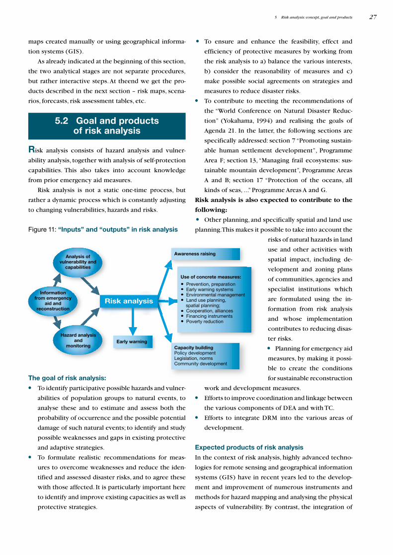
Awareness raising
Capacity buildingPolicy development Legislation, normsCommunity development
Informationfrom emergency
aid andreconstruction
Use of concrete measures:
Prevention, preparationEarly warning systemsEnvironmental management Land use planning,
spatial planning;Cooperation, alliancesFinancing instrumentsPoverty reduction
Early warning
maps created manually or using geographical informa-
tion systems (GIS).
As already indicated at the beginning of this section,
the two analytical stages are not separate procedures,
but rather interactive steps. At theend we get the pro-
ducts described in the next section – risk maps, scena-
rios, forecasts, risk assessment tables, etc.
5 Risk analysis: concept, goal and products 27
Figure 11: “Inputs” and “outputs” in risk analysis
The goal of risk analysis:
• To identify participative possible hazards and vulner-
abilities of population groups to natural events, to
analyse these and to estimate and assess both the
probability of occurrence and the possible potential
damage of such natural events; to identify and study
possible weaknesses and gaps in existing protective
and adaptive strategies.
• To formulate realistic recommendations for meas-
ures to overcome weaknesses and reduce the iden-
tified and assessed disaster risks, and to agree these
with those affected. It is particularly important here
to identify and improve existing capacities as well as
protective strategies.
• To ensure and enhance the feasibility, effect and
efficiency of protective measures by working from
the risk analysis to a) balance the various interests,
b) consider the reasonability of measures and c)
make possible social agreements on strategies and
measures to reduce disaster risks.
• To contribute to meeting the recommendations of
the “World Conference on Natural Disaster Reduc-
tion” (Yokahama, 1994) and realising the goals of
Agenda 21. In the latter, the following sections are
specifically addressed: section 7 “Promoting sustain-
able human settlement development”, Programme
Area F; section 13, “Managing frail ecosystems: sus-
tainable mountain development”, Programme Areas
A and B; section 17 “Protection of the oceans, all
kinds of seas, ...” Programme Areas A and G.
Risk analysis is also expected to contribute to the
following:
• Other planning, and specifically spatial and land use
planning.This makes it possible to take into account the
risks of natural hazards in land
use and other activities with
spatial impact, including de-
velopment and zoning plans
of communities, agencies and
specialist institutions which
are formulated using the in-
formation from risk analysis
and whose implementation
contributes to reducing disas-
ter risks.
• Planning for emergency aid
measures, by making it possi-
ble to create the conditions
for sustainable reconstruction
work and development measures.
• Efforts to improve coordination and linkage between
the various components of DEA and with TC.
• Efforts to integrate DRM into the various areas of
development.
Expected products of risk analysis
In the context of risk analysis, highly advanced techno-
logies for remote sensing and geographical information
systems (GIS) have in recent years led to the develop-
ment and improvement of numerous instruments and
methods for hazard mapping and analysing the physical
aspects of vulnerability. By contrast, the integration of
5.2 Goal and productsof risk analysis
Risk analysis consists of hazard analysis and vulner-
ability analysis, together with analysis of self-protection
capabilities. This also takes into account knowledge
from prior emergency aid measures.
Risk analysis is not a static one-time process, but
rather a dynamic process which is constantly adjusting
to changing vulnerabilities, hazards and risks.
social, economic and environmental variables into GIS
models,risk maps and risk analysis generally still remains
a challenge.
The products most frequently created in risk analy-
ses include hazard maps and so-called risk maps.
Different authors and regions use different names for
risk or hazard maps.They also have different levels of
data accuracy, and can be subdivided into three cate-
gories:
• Hazard maps: these are maps which give qualitative
and quantitative information on natural hazards,
e.g.by presenting the expected danger or maximum
level of danger or the event, e.g. slopes at risk from
landslides.
• Risk zone maps: these provide information on the
probability of occurrence (in the case of earth-
quakes, the contain the building standards needed
for disaster reduction).They are generally the result
or product of a hazard analysis.
• Risk maps are risk zone maps which also contain
quantitative information on the risk and the impacts
on people, property, environment, etc. Typically,
they take into account the physical aspects of
vulnerability, but not the social, economic and
political aspects.
Other products:
• Information from various analytical methods and
techniques (e.g. “Livelihood analyses”, FEMA) and
simulation models (e.g. NAXOS, SWAT, USLE) is
presented in text and diagrams. Generally, this infor-
mation is allocated to either the hazard or vulner-
ability analysis or both. References on the methods
and models cited are contained in the appendices to
these guidelines, available from the sector project
“Disaster Risk Management in Development Cooper-
ation”.
• Assessment tables and risk assessment matrix.
5 Risk analysis: concept, goal and products28
In carrying out a risk analysis and determining the
methods and techniques to be used in this, certain
conditions must be met and the following criteria must
be taken into account.
Before carrying out a RA, the following questions
should be explored or settled.
• Is there the political commitment to DRM? Are
preventive measures politically acknowledged? Or
do emergency aid measures do more for the institu-
tional image and political career?
• Is there financing for implementing the measures
derived from the risk analysis.
• Does a cost-benefit assessment indicate a positive
social benefit? Or is RA more expensive than possi-
ble damage from a natural event?
• Is the starting point an emergency aid measure, are
there follow-up measures (DEA,TC)?
• Is there an institutional and statutory basis for DRM
and RA? Are there developing and/or poverty reduc-
tion strategies which take into account disaster
risks?
• Is the affected population motivated and interested
in self-help?
1) The existence of political commitment to active
DRM is an absolute prerequisite. Just as important is
the existence of defined institutional responsibili-
ties for disaster reduction and disaster response.The
political framework should permit democratic con-
sultation processes and cooperation between and
with institutions.
2) There must be a realistic chance that the results of
the RA can be implemented and applied, i.e. there
must be resources available or capable of mobili-
sation.The results must be taken into account e.g. in
spatial and land use planning.
3) Cultural acceptability of the innovations (e.g.
methods and techniques) must be taken into account
in the interests of project sustainability. In addition,
promotion of self-organisation by the affected pop-
ulation and consideration of traditional and local
knowledge are of fundamental importance for
sustainability.
4) Besides the problems already referred to in the tran-
sition from emergency aid to normal TC, there is
often a further difficulty in the fact that experience
shows that the emergency aid instruments used (aid
shipments,food aid) often hinder “ownership” and
personal initiative among those affected.However,
both of these are basic elements of TC, which pri-
marily works with participative analysis and planning
instruments. To deal with this problem, a dual
1 Einführung 29
6 Elements in carrying outa risk analysis
6.1 Criteria fordetermining the methods
and instrumentsin applying risk analysis

Because the data available differs very widely in quan-
tity and quality in the various countries and project lo-
cations, methods always have to be adapted.
Participative approach
German TC has extensive and varied experience with
participative approaches and the use of participative in-
struments for analysis and planning.These participative
instruments are mostly based on the RRA13/PRA14
approaches and further developments of these methods.
RRA is a sociological approach developed in DC at the
start of the 80s in which a multidisciplinary team uses
nonstandardised simple methods and incorporates the
knowledge of the local population in order to rapidly
collect,analyse and evaluate information about rural life
and rural resources which is relevant for action. PRA
methods are indicated if it is a question of a rapid,
action-oriented assessment of local knowledge, needs
and potentials.PRA stresses a proactive role in problem
analysis and planning for those affected, with outsiders
playing the role of “facilitators”. Today, the emphasis in
these approaches is on “participatory”, while “rapid” is
less important. PRA as an internationally established
term and concept is understand here in the sense of
“participatory appraisal”, with the emphasis shifted
from “analysis” and “rural” to planning and active
problem solving, both in a rural context and elsewhere.
The basis for the increased importance of partici-
pative instruments and thinking,which has set the tone
in many projects, is the acknowledgment that the con-
ventional (top-down) planning approaches have pro-
duced little success, despite high costs. The parti-
cipatory approach is tied to the goal of enhancing the
planning competence, autonomy and organisational
capacity of previously disadvantaged (target) groups,
and to integrating excluded and marginalised groups.
A central aspect of applying participative planning
methods is mutual learning on the part of those in-
volved.
In developing countries, the weak public structures
for disaster protection mean that people are particular-
ly dependent on self-help. This gives rise to the chal-
lenge of meshing state-organised disaster protection
with private aid organisations and self-help activities by
the citizens. Disaster protection and prevention meas-
ures – where present at all – are mostly managed at
strategy should be pursued during emergency aid
which combines aid contributions with promotion
of “ownership” and personal initiative.
5) Experience in DC has shown that it is easier to reach
a consensus between technicians,politicians and the
local population if highly visible protective meas-
ures are involved (which are often expensive and do
not always do much for disaster reduction) than if
less spectacular but possibly more effective meas-
ures are involved. One example of this is ineffective
protective walls against landslides instead of ade-
quate water management in uplying regions.This is
a question not only of different interests but also
of different perceptions of hazards. To achieve
optimal solutions in consensus with all participants,
measures such as transparent information manage-
ment, disclosure and discussion of the various inter-
ests and clarification of the various roles are impor-
tant and useful.
6) Risk analyses can be applied at various levels
and in different contexts. When deciding on the
approach, it is necessary first to investigate or clari-
fy a) whether the aim is to reduce disaster risk at
local, regional or national level, and b) whether the
product is intended for a community (implemen-
tation), technical agency (research, analysis), finan-
cial institution (cost-benefit analyses, profitability)
or insurance company (tariffs). The comments in
the present guidelines focus on the local level for
strengthening local structures, and are oriented
towards implementation.
7) Even with experienced planners and specialists,
there is still a tendency apparent to give too much
emphasis to inputs for data collection and analy-
sis, leaving too little time and resources for evalu-
ation of data and formulation of solidly-based plan-
ning statements,and particularly for their agreement
with actors and subsequent implementation. Often,
vast quantities of data are collected which cannot be
used later or have to be aggregated after being
collected in too much detail, and which cannot be
used to derive any direct statements for planning. It
is accordingly important to clearly define and agree
the concrete goals for the risk analysis and the data
required.
Based on analysis of these questions and criteria,the me-
thods and instruments for the risk analysis must be iden-
tified, modified or developed.
6 Elements in carrying out a risk analysis30
13 RRA = Rapid Rural Appraisal14 PRA = Participatory Rural Appraisal
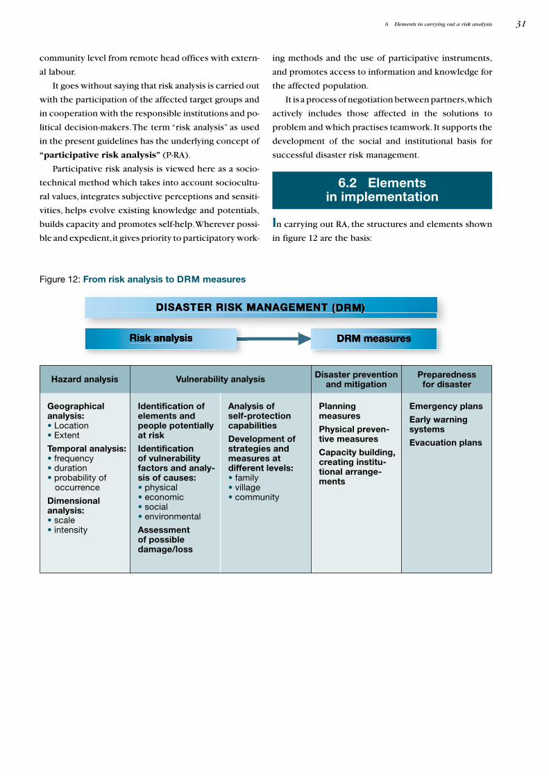
6 Elements in carrying out a risk analysis 31
Figure 12: From risk analysis to DRM measures
Geographicalanalysis:• Location• Extent
Temporal analysis:• frequency• duration• probability of
occurrence
Dimensionalanalysis:• scale• intensity
Disaster preventionand mitigation
Planningmeasures
Physical preven-tive measures
Capacity building,creating institu-tional arrange-ments
Identification ofelements andpeople potentiallyat risk
Identificationof vulnerabilityfactors and analy-sis of causes:• physical• economic• social• environmental
Assessmentof possibledamage/loss
Analysis ofself-protectioncapabilities
Development ofstrategies andmeasures atdifferent levels:• family• village• community
Emergency plans
Early warningsystems
Evacuation plans
Hazard analysis Vulnerability analysis Preparednessfor disaster
community level from remote head offices with extern-
al labour.
It goes without saying that risk analysis is carried out
with the participation of the affected target groups and
in cooperation with the responsible institutions and po-
litical decision-makers.The term “risk analysis” as used
in the present guidelines has the underlying concept of
“participative risk analysis” (P-RA).
Participative risk analysis is viewed here as a socio-
technical method which takes into account sociocultu-
ral values, integrates subjective perceptions and sensiti-
vities, helps evolve existing knowledge and potentials,
builds capacity and promotes self-help.Wherever possi-
ble and expedient,it gives priority to participatory work-
6.2 Elementsin implementation
In carrying out RA, the structures and elements shown
in figure 12 are the basis:
ing methods and the use of participative instruments,
and promotes access to information and knowledge for
the affected population.
It is a process of negotiation between partners,which
actively includes those affected in the solutions to
problem and which practises teamwork. It supports the
development of the social and institutional basis for
successful disaster risk management.