
Rainer Lehfeldt, Volker Barthel Bundesanstalt für Wasserbau Hamburg - Workshop 10.03.2004 Büsum...
22
Rainer Lehfeldt, Volker Barthel Bundesanstalt für Wasserbau Hamburg - Workshop 10.03.2004 Büsum Ziele und Ergebnisse von NOKIS aus der Sicht des KFKI
-
Upload
minna-bauer -
Category
Documents
-
view
216 -
download
0
Transcript of Rainer Lehfeldt, Volker Barthel Bundesanstalt für Wasserbau Hamburg - Workshop 10.03.2004 Büsum...
Rainer Lehfeldt, Volker BarthelBundesanstalt für Wasserbau
Hamburg
- Workshop10.03.2004
Büsum
Ziele und Ergebnisse von NOKIS aus der Sicht des KFKI
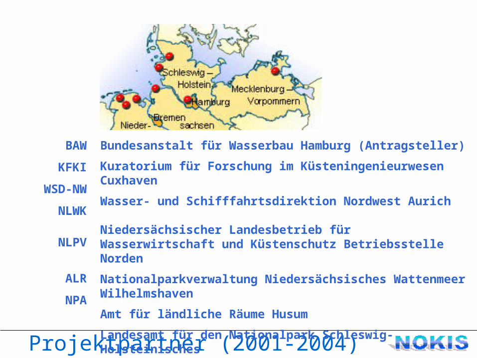
Projektpartner (2001-2004)
Bundesanstalt für Wasserbau Hamburg (Antragsteller)Kuratorium für Forschung im Küsteningenieurwesen CuxhavenWasser- und Schifffahrtsdirektion Nordwest Aurich
Niedersächsischer Landesbetrieb für Wasserwirtschaft und Küstenschutz Betriebsstelle NordenNationalparkverwaltung Niedersächsisches Wattenmeer WilhelmshavenAmt für ländliche Räume HusumLandesamt für den Nationalpark Schleswig-Holsteinisches Wattenmeer Tönning
BAW
KFKI
WSD-NW
NLWK
NLPV
ALR
NPA
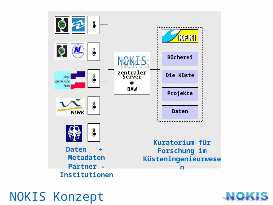
NOKIS Konzept
Die Küste
Bücherei
Projekte
Daten
mdb
mdb
mdb
mdb
mdb
zentraler Server
@BAW
Kuratorium für Forschung im
KüsteningenieurwesenDaten + Metadaten
Partner - Institutionen
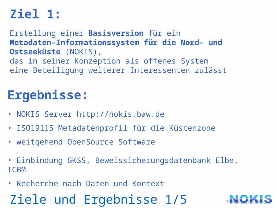
Ziele und Ergebnisse 1/5
Ziel 1:Erstellung einer Basisversion für ein Metadaten-Informationssystem für die Nord- und Ostseeküste (NOKIS), das in seiner Konzeption als offenes System eine Beteiligung weiterer Interessenten zulässt
Ergebnisse:• NOKIS Server http://nokis.baw.de
• ISO19115 Metadatenprofil für die Küstenzone
• weitgehend OpenSource Software
• Einbindung GKSS, Beweissicherungsdatenbank Elbe, ICBM
• Recherche nach Daten und Kontext
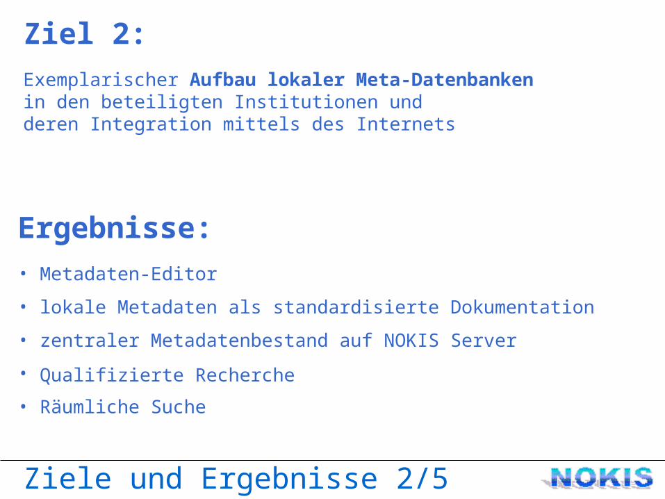
Ziele und Ergebnisse 2/5
Ziel 2:Exemplarischer Aufbau lokaler Meta-Datenbanken in den beteiligten Institutionen und deren Integration mittels des Internets
Ergebnisse:• Metadaten-Editor
• lokale Metadaten als standardisierte Dokumentation
• zentraler Metadatenbestand auf NOKIS Server
• Qualifizierte Recherche • Räumliche Suche
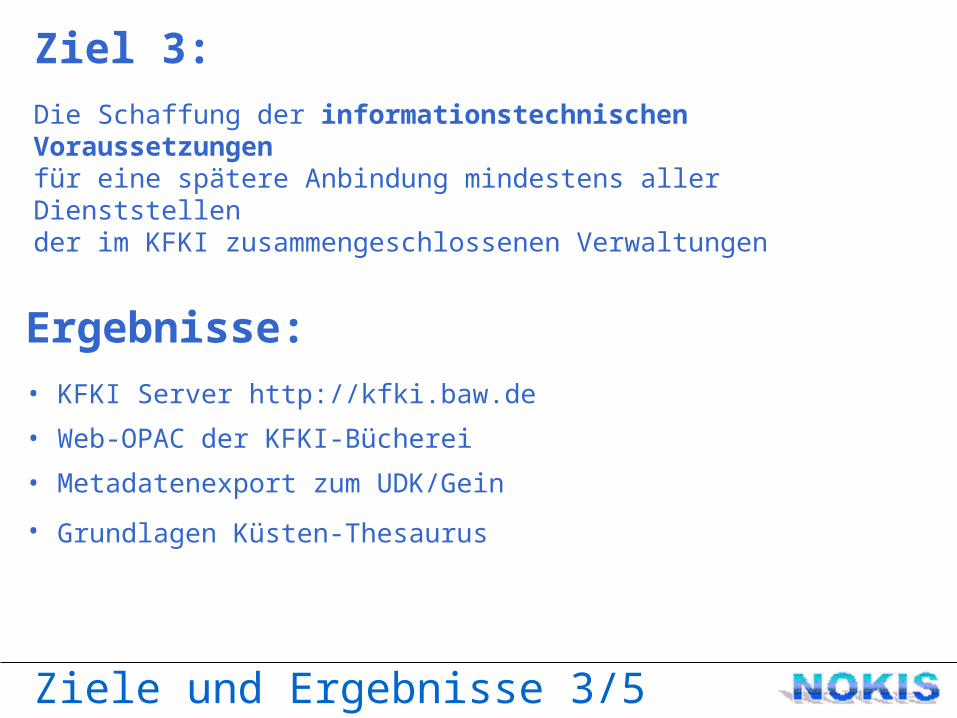
Ziele und Ergebnisse 3/5
Ziel 3:Die Schaffung der informationstechnischen Voraussetzungen für eine spätere Anbindung mindestens aller Dienststellen der im KFKI zusammengeschlossenen Verwaltungen
Ergebnisse:• KFKI Server http://kfki.baw.de
• Web-OPAC der KFKI-Bücherei
• Metadatenexport zum UDK/Gein
• Grundlagen Küsten-Thesaurus
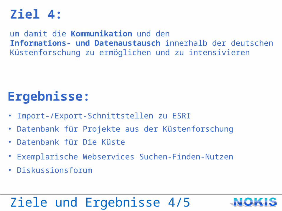
Ziele und Ergebnisse 4/5
Ziel 4:um damit die Kommunikation und den Informations- und Datenaustausch innerhalb der deutschen Küstenforschung zu ermöglichen und zu intensivieren
Ergebnisse:• Import-/Export-Schnittstellen zu ESRI
• Datenbank für Projekte aus der Küstenforschung
• Datenbank für Die Küste
• Exemplarische Webservices Suchen-Finden-Nutzen • Diskussionsforum
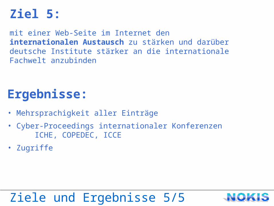
Ziele und Ergebnisse 5/5
Ziel 5:mit einer Web-Seite im Internet den internationalen Austausch zu stärken und darüber deutsche Institute stärker an die internationale Fachwelt anzubinden
Ergebnisse:• Mehrsprachigkeit aller Einträge
• Cyber-Proceedings internationaler KonferenzenICHE, COPEDEC, ICCE
• Zugriffe
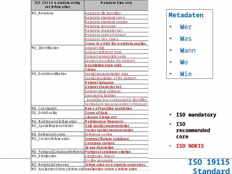
Iso 19115
ISO 19115 metadata entity set information
Metadata Elements
Metadata file identifierMetadata standard nameMetadata standard versionMetadata languageMetadata character setMetadata point of contactMetadata time stampScope to which the metadata appliesDataset titleDataset reference dateDataset responsible partyAbstract describing the datasetDescriptive keywordsStatusSpatial representation typeSpatial resolution of the datasetDataset languageDataset character setDataset topic categoryGeographic location bounding box or geographic identifierVertical and temporal extent of dataset
MD_ Constraints Name of handling restrictionScope of dataLineage Statement
MD_ MaintenanceInformation Maintenance frequencyGrid spatial representationVector spatial representation
MD_ ReferenceSystem Reference systemExternal feature catalogueCoverage contentImage descrption
MD_ PortrayalCatalogueReferencePortrayal catalogue citationDistribution formatOn-line ressource
MD_ MetadataExtension Information on metadata extensionsMD_ ApplicationSchemaInformationApplication schema information
MD_ SpatialRepresentation
MD_ ContentInformation
MD_ Distribution
MD_ Metadata
MD_ Identification
MD_ DataIdentification
DQ_ DataQuality • ISO mandatory
ISO 19115 metadata entity set information
Metadata Elements
Metadata file identifierMetadata standard nameMetadata standard versionMetadata languageMetadata character setMetadata point of contactMetadata time stampScope to which the metadata appliesDataset titleDataset reference dateDataset responsible partyAbstract describing the datasetDescriptive keywordsStatusSpatial representation typeSpatial resolution of the datasetDataset languageDataset character setDataset topic categoryGeographic location bounding box or geographic identifierVertical and temporal extent of dataset
MD_ Constraints Name of handling restrictionScope of dataLineage Statement
MD_ MaintenanceInformation Maintenance frequencyGrid spatial representationVector spatial representation
MD_ ReferenceSystem Reference systemExternal feature catalogueCoverage contentImage descrption
MD_ PortrayalCatalogueReferencePortrayal catalogue citationDistribution formatOn-line ressource
MD_ MetadataExtension Information on metadata extensionsMD_ ApplicationSchemaInformationApplication schema information
MD_ SpatialRepresentation
MD_ ContentInformation
MD_ Distribution
MD_ Metadata
MD_ Identification
MD_ DataIdentification
DQ_ DataQuality
ISO 19115 Standard
Metadaten
• Wer
• Was
• Wann
• Wo
• Wie
• ISO mandatory• ISO
recommended core
ISO 19115 metadata entity set information
Metadata Elements
Metadata file identifierMetadata standard nameMetadata standard versionMetadata languageMetadata character setMetadata point of contactMetadata time stampScope to which the metadata appliesDataset titleDataset reference dateDataset responsible partyAbstract describing the datasetDescriptive keyw ordsStatusSpatial representation typeSpatial resolution of the datasetDataset languageDataset character setDataset topic categoryGeographic location bounding box or geographic identifierVertical and temporal extent of dataset
MD_ Constraints Name of handling restrictionScope of dataLineage Statement
MD_ MaintenanceInformation Maintenance frequencyGrid spatial representationVector spatial representation
MD_ ReferenceSystem Reference systemExternal feature catalogueCoverage contentImage descrption
MD_ PortrayalCatalogueReferencePortrayal catalogue citationDistribution formatOn-line ressource
MD_ MetadataExtension Information on metadata extensionsMD_ ApplicationSchemaInformationApplication schema information
MD_ SpatialRepresentation
MD_ ContentInformation
MD_ Distribution
MD_ Metadata
MD_ Identification
MD_ DataIdentification
DQ_ DataQuality • ISO mandatory• ISO
recommended core
• ISO NOKIS
ISO 19115 metadata entity set information
Metadata Elements
Metadata file identifierMetadata standard nameMetadata standard versionMetadata languageMetadata character setMetadata point of contactMetadata time stampScope to which the metadata appliesDataset titleDataset reference dateDataset responsible partyAbstract describing the datasetDescriptive keywordsStatusSpatial representation typeSpatial resolution of the datasetDataset languageDataset character setDataset topic categoryGeographic location bounding box or geographic identifierVertical and temporal extent of dataset
MD_ Constraints Name of handling restrictionScope of dataLineage Statement
MD_ MaintenanceInformation Maintenance frequencyGrid spatial representationVector spatial representation
MD_ ReferenceSystem Reference systemExternal feature catalogueCoverage contentImage descrption
MD_ PortrayalCatalogueReferencePortrayal catalogue citationDistribution formatOn-line ressource
MD_ MetadataExtension Information on metadata extensionsMD_ ApplicationSchemaInformationApplication schema information
MD_ SpatialRepresentation
MD_ ContentInformation
MD_ Distribution
MD_ Metadata
MD_ Identification
MD_ DataIdentification
DQ_ DataQuality
ISO 19115 Standard
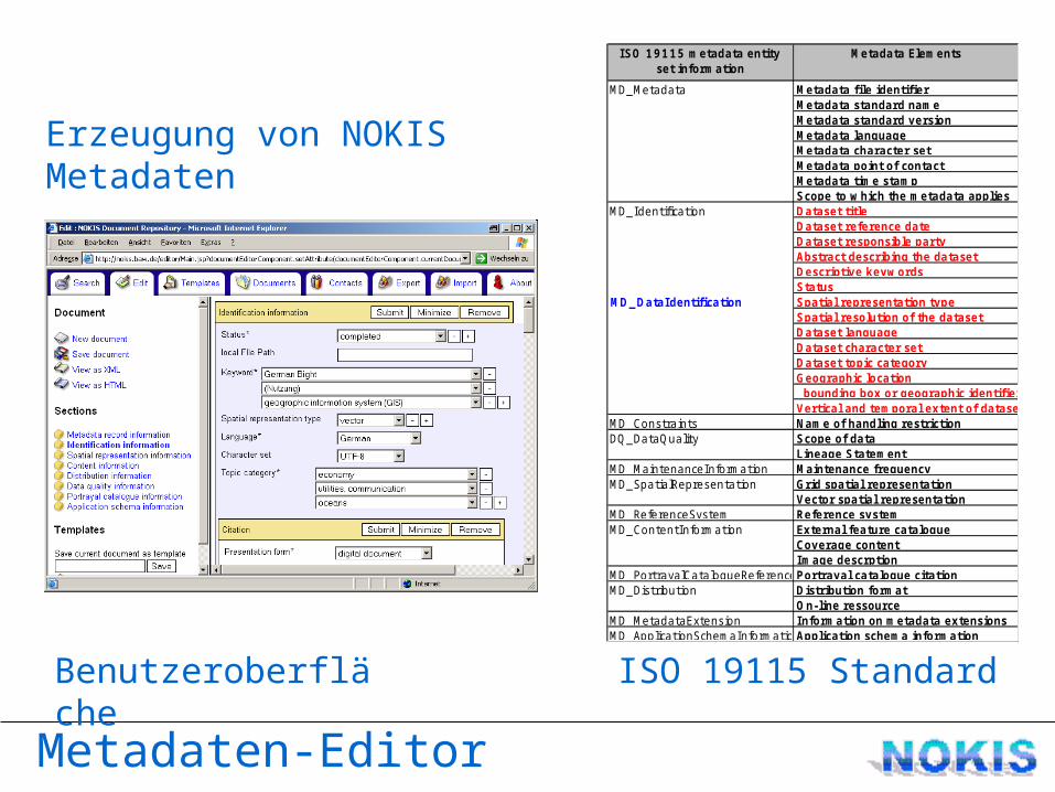
Metadaten-Editor
Benutzeroberfläche
Erzeugung von NOKIS Metadaten
ISO 19115 metadata entity set information
Metadata Elements
Metadata file identifierMetadata standard nameMetadata standard versionMetadata languageMetadata character setMetadata point of contactMetadata time stampScope to which the metadata appliesDataset titleDataset reference dateDataset responsible partyAbstract describing the datasetDescriptive keywordsStatusSpatial representation typeSpatial resolution of the datasetDataset languageDataset character setDataset topic categoryGeographic location bounding box or geographic identifierVertical and temporal extent of dataset
MD_ Constraints Name of handling restrictionScope of dataLineage Statement
MD_ MaintenanceInformation Maintenance frequencyGrid spatial representationVector spatial representation
MD_ ReferenceSystem Reference systemExternal feature catalogueCoverage contentImage descrption
MD_ PortrayalCatalogueReferencePortrayal catalogue citationDistribution formatOn-line ressource
MD_ MetadataExtension Information on metadata extensionsMD_ ApplicationSchemaInformationApplication schema information
MD_ SpatialRepresentation
MD_ ContentInformation
MD_ Distribution
MD_ Metadata
MD_ Identification
MD_ DataIdentification
DQ_ DataQuality
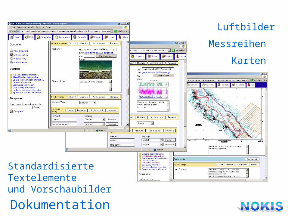
Dokumentation
Standardisierte Textelemente
und Vorschaubilder
Karten
Messreihen
Luftbilder
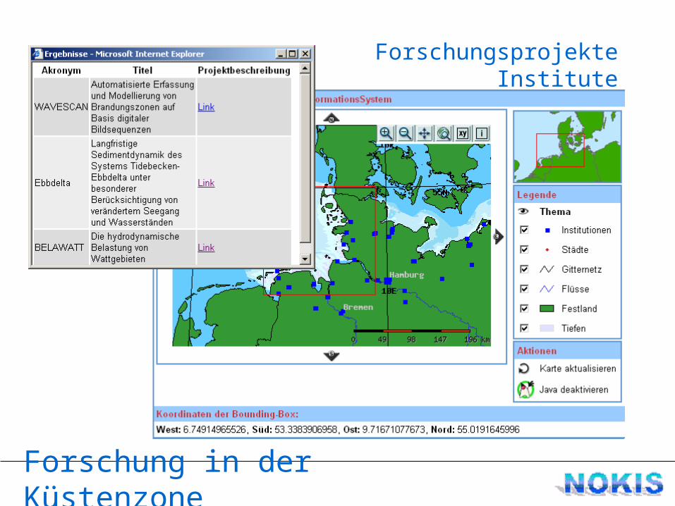
Forschung in der Küstenzone
Dienststellen und InstituteForschungsprojekte
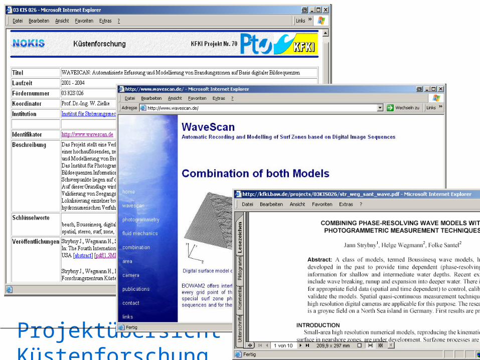
Projektübersicht Küstenforschung
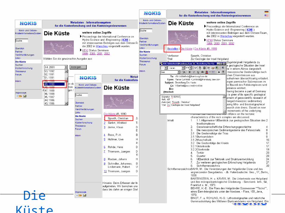
Die Küste
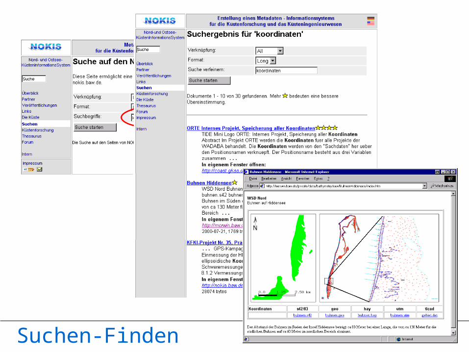
Suchen-Finden
Suchen-Finden-Nutzen
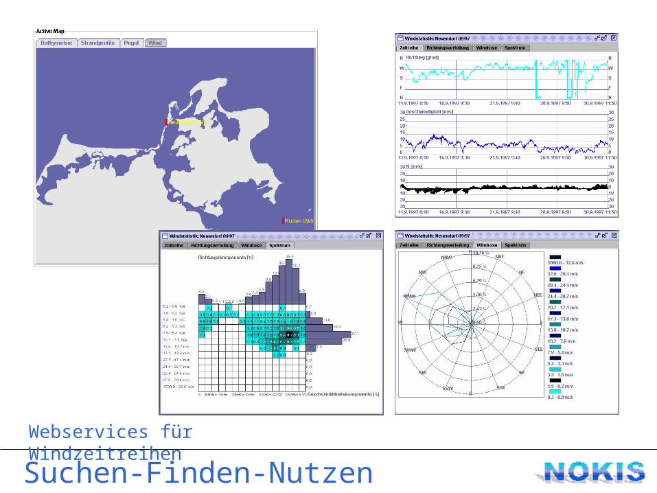
Webservices für Windzeitreihen
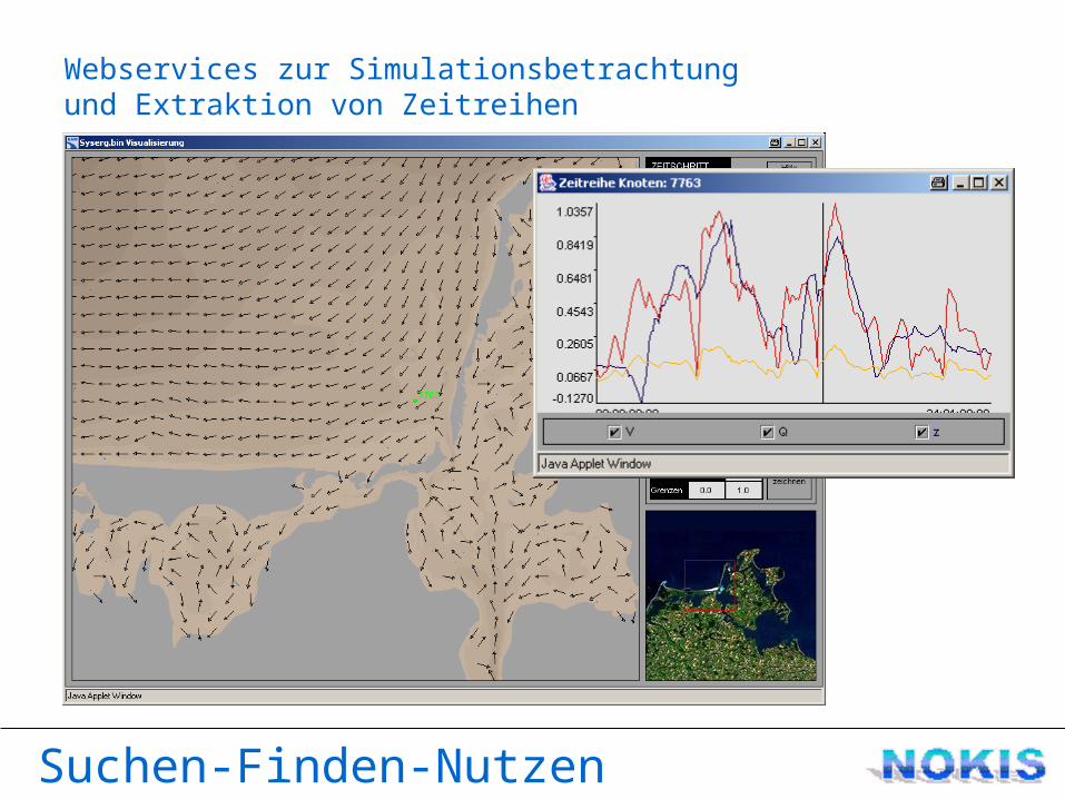
Webservices zur Simulationsbetrachtung
Suchen-Finden-Nutzen
und Extraktion von Zeitreihen
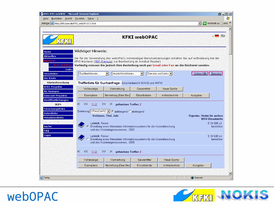
webOPAC
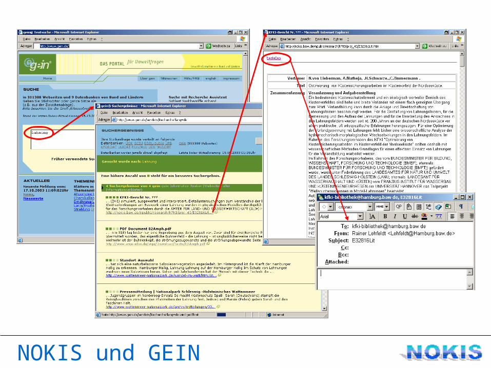
NOKIS und GEIN
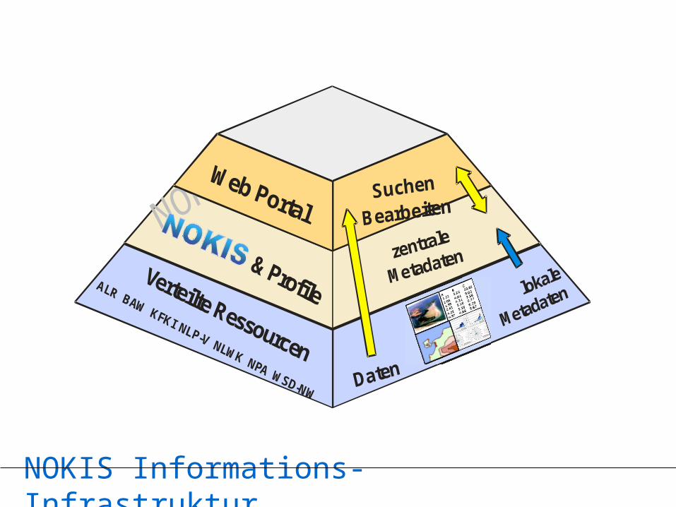
NOKIS Informations-Infrastruktur
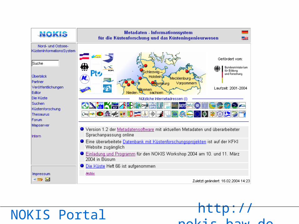
NOKIS-Portal
NOKIS Portal http://nokis.baw.de


![Vorlesung15.ppt [Kompatibilis mód] - KFKI Telephelybarnai/univet/Vorlesung_15.pdf · Biomechanik, Mechanische Eigenschaften von biologischen Stoffen BIOPHYSIK 15. Vorlesung 2 Einleitung](https://static.fdokument.com/doc/165x107/5e1e2f8b642a48570c209dc5/kompatibilis-md-kfki-telephely-barnaiunivetvorlesung15pdf-biomechanik.jpg)