RGZM – Tagungen 34 (Mainz 2018)€¦ · Archaeology + History + Geosciences« at the...
28
Römisch-Germanisches Zentralmuseum Leibniz-Forschungsinstitut für Archäologie Verlag des Römisch-Germanischen Zentralmuseums Mainz 2018 OFFPRINT RGZM – TAGUNGEN Band 34 zugleich INTERDISZIPLINÄRE FORSCHUNGEN zu den Häfen von der Römischen Kaiserzeit bis zum Mittelalter in Europa Band 5 Herausgegeben von Claus von Carnap-Bornheim, Falko Daim, Peter Ettel und Ursula Warnke Claus von Carnap-Bornheim · Falko Daim Peter Ettel · Ursula Warnke (eds) HARBOURS AS OBJECTS OF INTERDISCIPLINARY RESEARCH – ARCHAEOLOGY + HISTORY + GEOSCIENCES International Conference »Harbours as objects of interdisciplinary research – Archaeology + History + Geosciences« at the Christian-Albrechts-University in Kiel, 30.9.-3.10.2015, within the framework of the Special Research Program- me (DFG-SPP 1630) »Harbours from the Roman Period to the Middle Ages«
Transcript of RGZM – Tagungen 34 (Mainz 2018)€¦ · Archaeology + History + Geosciences« at the...

Römisch-Germanisches Zentralmuseum
Leibniz-Forschungsinstitut für Archäologie
Verlag des Römisch-Germanischen Zentralmuseums Mainz 2018
OFFPRINT
RGZM – TAGUNGEN Band 34zugleich
INTERDISZIPLINÄRE FORSCHUNGEN zu den Häfen von der Römischen Kaiserzeit bis zum Mittelalter in Europa Band 5Herausgegeben von Claus von Carnap-Bornheim, Falko Daim, Peter Ettel und Ursula Warnke
Claus von Carnap-Bornheim · Falko Daim Peter Ettel · Ursula Warnke (eds)
HARBOURS AS OBJECTS OF INTERDISCIPLINARY RESEARCH – ARCHAEOLOGY + HISTORY + GEOSCIENCES
International Conference »Harbours as objects of interdisciplinary research – Archaeology + History + Geosciences« at the Christian-Albrechts-University in Kiel, 30.9.-3.10.2015, within the framework of the Special Research Program-me (DFG-SPP 1630) »Harbours from the Roman Period to the Middle Ages«

Redaktion: Ilka Elisabeth Rau (ZBSA), Nina Marschler (Duisburg), Claudia Nickel, Marie Röder (RGZM)Englisches Lektorat: Ilka Elisabeth Rau (ZBSA), Wilson Huntley (Göttingen)Satz: Dieter Imhäuser, Hofheim a. T.Bildbearbeitung: Manfred Albert (RGZM)Umschlaggestaltung: Claudia Nickel (RGZM)
Bibliografische Information der Deutschen Nationalbibliothek
Die Deutsche Nationalbibliothek verzeichnet diese Publikation in der Deutschen Nationalbibliografie: Detaillierte bibliografische Daten sind im Internet über http://dnb.d-nb.de abrufbar.
ISBN 978-3-88467-293-8ISSN 1862-4812
© 2018 Verlag des Römisch-Germanischen Zentralmuseums
Das Werk ist urheberrechtlich geschützt. Die dadurch begründeten Rechte, insbesondere die der Übersetzung, des Nachdrucks, der Entnahme von Abbildungen, der Funk- und Fernsehsendung, der Wiedergabe auf fotomechanischem (Fotokopie, Microkopie) oder ähnlichem Wege und der Speicherung in Datenverarbeitungs-anlagen, Ton- und Bildträgern bleiben, auch bei nur auszugsweiser Verwertung, vorbehalten. Die Vergütungsansprüche des §54, Abs.2, UrhG. werden durch die Verwertungsgesellschaft Wort wahrgenommen.
Druck: johnen-druck GmbH & Co. KG, Bernkastel-KuesPrinted in Germany.
Die Tagung wurde gefördert von der

V
CONTENTS
Foreword . . . . . . . . . . . . . . . . . . . . . . . . . . . . . . . . . . . . . . . . . . . . . . . . . . . . . . . . . . . . . . . . . . . . . . . IX
Claus von Carnap-Bornheim · Falko Daim · Peter Ettel · Ursula WarnkeHarbours as Objects of Interdisciplinary Research – Archaeology + History + Geosciences . . . . . . . . . . . . 1
Introductions
Johannes Preiser-Kapeller · Lukas WertherConnecting Harbours. A Comparison of Traffic Networks across Ancient and Medieval Europe . . . . . . . . 7
Ralf BleileNo Harbours without Ships, no Ships without Harbours – Shipwrecks as Maritime Cultural Heritage of the Baltic Sea . . . . . . . . . . . . . . . . . . . . . . . . . . . . . . . . . . 33
Marianne Nitter · Joris CoolenAny Way the Wind Blows … Wind Fetch as a Determinant Factor of the Quality of Landing Sites . . . . . 45
Thomas Engel · Axel Kunz · Hartmut Müller · Lukas WertherTowards a Virtual Research Environment for Ancient Harbour Data . . . . . . . . . . . . . . . . . . . . . . . . . . . . 59
The Mediterranean
Assaf Yasur-Landau · Ehud Arkin Shalev · Paula Rut Zajac · Gil GambashRethinking the Anchorages and Harbours of the Southern Levant 2000 BC - 600 AD . . . . . . . . . . . . . . . 73
Stefan Feuser · Felix Pirson · Martin SeeligerThe Harbour Zones of Elaia – the Maritime City of Pergamon . . . . . . . . . . . . . . . . . . . . . . . . . . . . . . . . 91
Julia Daum · Martina Seifert The Adriatic Communication Area: Functional Structure of Roman Imperial Port Cities and their Facilities along the Italic and Dalmatian Coasts . . . . . . . . . . . . . . . . . . . . . . . . . . . . . . . . . . . 105
Antonella Antonazzo · Marina Maria Serena Nuovo Two Ancient Landing Places on the Adriatic Sea: Natural Elements and Anthropogenic Infrastructures at Cala Incina and Torre Santa Sabina (Puglia / I) . . . . . . . . . . . . . . . . . . 113
Julia DaumTrajan’s Harbours at the Tyrrhenian Coast . . . . . . . . . . . . . . . . . . . . . . . . . . . . . . . . . . . . . . . . . . . . . . 133
VI
Nicolas Carayon · Simon J. Keay · Pascal Arnaud · Corinne Sanchez The Harbour System of Narbo Martius (Narbonne / F) and its Facilities during Antiquity . . . . . . . . . . . . 151
Ada Lasheras González · Patricia Terrado Ortuño New Approaches to the Study of the Harbour of Tarraco: Archaeological and Literary Research (3rd Century BC - 8th Century AD) . . . . . . . . . . . . . . . . . . . . . . . . . . . . . . . . . . . . . . . 165
Geosciences
Vivien Mathé · Guillaume Bruniaux · Adrien Camus · Julien Cavéro · Camille Faïsse Marie-Pierre Jézégou · François Lévêque · Corinne Sanchez Geophysical Investigations into the Roman Port System of Narbonne . . . . . . . . . . . . . . . . . . . . . . . . . 185
Valentina Caminneci · Vincenzo Cucchiara · Giuseppe Presti Geoarchaeology at the Ancient Harbour of Agrigento . . . . . . . . . . . . . . . . . . . . . . . . . . . . . . . . . . . . . 195
Iconographic and Written Sources
Stefan FeuserImages and Imaginations of Roman Imperial Harbours . . . . . . . . . . . . . . . . . . . . . . . . . . . . . . . . . . . . 209
Dominik Heher · Grigori SimeonovCeremonies by the Sea. Ships and Ports in Byzantine Imperial Display (4th - 12th Centuries) . . . . . . . . . . 221
Alkiviadis GinalisEmperor or Bishop? Skiathos and the Byzantine Harbour Architecture in the 6th Century AD . . . . . . . . 249
Myrto Veikou · Ingela NilssonPorts and Harbours as Heterotopic Entities in Byzantine Literary Texts . . . . . . . . . . . . . . . . . . . . . . . . . 265
The North Sea and the Baltic
Ingo Eichfeld · Daniel NöslerFarmers, Merchants, Seafarers: a New Discovery of an Emporium of the 1st Millennium AD on the Southern Lower Elbe . . . . . . . . . . . . . . . . . . . . . . . . . . . . . . . . . . . . . . . . . . . . . . . . . . . . . . . . 281
Philip LüthHamburg-Harburg, the Harbour of a Small Medieval Town . . . . . . . . . . . . . . . . . . . . . . . . . . . . . . . . . 301

VII
Bente Sven Majchczack · Steffen Schneider · Tina Wunderlich · Dennis Wilken Wolfgang Rabbel · Martin SegschneiderEarly Medieval Trading Sites on the North-Frisian Island of Föhr. First Results of Fieldwork in Witsum and Goting . . . . . . . . . . . . . . . . . . . . . . . . . . . . . . . . . . . . . . . . . 311
Felix RöschThe 11th Century Schleswig Waterfront. Formation, Development and Actors of a Commercial Hotspot . . . . . . . . . . . . . . . . . . . . . . . . . . . . . . . . . . . . . . . . . . . . . . . . . . . . . . . . . . 329
Inland Navigation
Lukas Werther · Lars Kröger · André Kirchner · Christoph Zielhofer · Eva Leitholdt Michael Schneider · Sven Linzen · Stefanie Berg-Hobohm · Peter EttelFossata Magna – a Canal Contribution to Harbour Construction in the 1st Millennium AD . . . . . . . . . 355
Andreas Wunschel · Peter Ettel · Michael Hein · Sven Linzen Christopher-Bastian Roettig · Michael Schneider · Lukas WertherThe Waterfront of Karlburg and Salz in the Early and High Middle Ages – Interdisciplinary (Geo)Archaeological and Geophysical Studies . . . . . . . . . . . . . . . . . . . . . . . . . . . . . . . 373
Lars KrögerFerry Stations as Small Harbours. The Role of River Crossings in the Workaday Life at Southern German Rivers . . . . . . . . . . . . . . . . . . . . . . . . . . . . . . . . . . . . . . . . . . . . . . . . . . . . . . . . . 403
Manuela MirschenzThe Rhine as a European Transportation Route in Roman Times . . . . . . . . . . . . . . . . . . . . . . . . . . . . . 415
Mark DriessenThe Logistic Function of the Rhine-Meuse Delta in the Roman Period: the Harbour Town of Voorburg-Arentsburg as a Case-Study . . . . . . . . . . . . . . . . . . . . . . . . . . . . . . . . 437
List of Contributors . . . . . . . . . . . . . . . . . . . . . . . . . . . . . . . . . . . . . . . . . . . . . . . . . . . . . . . . . . . . . . . 459


IX
FOREWORD
The Priority Programme 1630 »Harbours from the Roman Period to the Middle Ages« funded by the Ger-man Research Foundation (Deutsche Forschungsgemeinschaft) in the years 2011-2018 has made it its prio-rity to unite and connect multidimensional approaches to harbour research within the vast research area of the North Atlantic to the Mediterranean. Modern research of the last three to four decades has particularly shown how the integration of geophysical and geoarchaeological methods has brought new insights into interdisciplinary and interpretational approaches. Thus the logical consequence was to dedicate the first in-ternational conference on the framework of the Priority Programme to this approach and its wide discussion. It took place from 30 September to 3 October 2015 with the title »Harbours as objects of interdisciplinary research – Archaeology + History + Geosciences«. About 130 participants from 15 nations with 70 lectures presented their work approaches and results within the five sections of the conference: »Plenum keynote-lectures«, »Geophysics and Field Research: Developing methods«, »Geoarchaeology: Changing Harbour Environments«, »Archaeological Features: Harbour Facilities and Infrastructure«, »Written and Iconographic Sources: Complementing the Material Evidence«. The ceremonial address of the evening was given by Sabi-ne Ladstätter (Vienna) on the harbour of Ephesos. On the last day of the conference the participants visited the Viking Museum Haithabu as well as exhibitions at the Schleswig-Holsteinisches Landesmuseum Schloss Gottorf in Schleswig. Subsequent to the conference in Kiel, the initiators of the Priority Programme decided on what at first glance appears to be an unusual publication strategy in which the predominantly archaeologically and historically oriented papers are being published in the present volume, whereas some mainly geophysical and geoarchaeological papers will be published in Quaternary International Special Issue »Integrated geo-physical and (geo)archaeological explorations in wetlands« (guest editors: Christoph Zielhofer, Wolfgang Rabbel, Stefanie Berg-Hobohm, Tina Wunderlich), thereby reaching different milieus, which are, however, interconnected by their interdisciplinary research on harbours. Consequently, the thematic structure of the present volume will differ from the actual conference and the submitted contributions are arranged regio-nally as well as topically. Our thanks go especially to Ilka E. Rau, who was both responsible for organising the conference as well as for the editorial responsibilities of this volume. Moreover, our thanks go to the editorial team of the RGZM in Mainz.
The initiators of the SPP 1630 »Harbours from the Roman Period to the Middle Ages«Claus von Carnap-BornheimFalko DaimPeter EttelUrsula Warnke

Harbours as Objects of Interdisciplinary Research – Archaeology + History + Geosciences 133
JULIA DAUM
TRAJAN’S HARBOURS ON THE TYRRHENIAN COAST
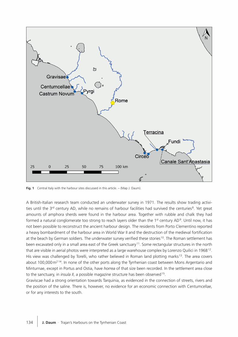
At the beginning of the 2nd century AD, the Emperor Trajan (98-117 AD) heavily invested in the infrastruc-ture of Italy. Besides renovating the Via Appia, he built several harbours on the Italian coasts. In Ancona on the Adriatic Sea, his monumental arch marks the end of the mole and commemorates the restoration of the harbour until today 1. On the western coast of Italy, he had constructed Centumcellae, Portus and Ter-racina, of which Portus near the mouth of the Tiber is the most famous. It received its special status from the relations between Rome and Portus and between Portus and Ostia. The latter supplied the biggest Roman city and modern research regards it to be a distribution centre for the western Mediterranean 2. Thus, the emperor’s interest in Portus is obvious. The other Tyrrhenian harbours of Centumcellae and Terracina are much smaller and were built at a time when both the economy and the demographic density were declining in Etruria and Latium. How did these new harbours affect the long-grown harbour system? An understanding of this development requires a closer look at the harbour landscape along the coasts in their respective vicinity. Are there other harbours close by and, if so, how were they connected to the hinterland? Centumcellae is situated on the southern coast of Etruria, equivalent to regio VII after the division of Italy into districts by Augustus 3. It is surrounded by three older harbours: Pyrgi, Castrum Novum and Graviscae. Terracina is located in Latium et Campania, regio I. Its next neighbouring harbours are Circeo and Fundi. This article will first examine the harbour landscape before Trajan’s building programme. In a next step, the harbours Centumcellae and Terracina will be presented, and lastly an evaluation of their possible impact on the neighbouring harbours will be put forward.
ETRURIA
In 108/109 AD, Pliny the Younger praised Trajan’s new villa at Centumcellae in a letter to his friend Cor-nelianus. He also showed himself impressed by the new harbour facilities. The letter ends with the words »habebit hic portus et iam habet nomen auctoris eritque vel maxime salutaris. nam per longissimum spa-tium litus importuosum hoc receptaculo utetur« 4. At a closer look, the declaration of »no other harbours along the coast« does not hold true. There are three harbours close by (fig. 1): Graviscae 15 km to the north-west, Castrum Novum (7 km) and Pyrgi (20 km) to the south-east. These harbours were established in the 7th and 3rd centuries BC. The harbours Graviscae and Pyrgi were closely connected to the Etruscan cities Tarquinia and Caere.
Graviscae
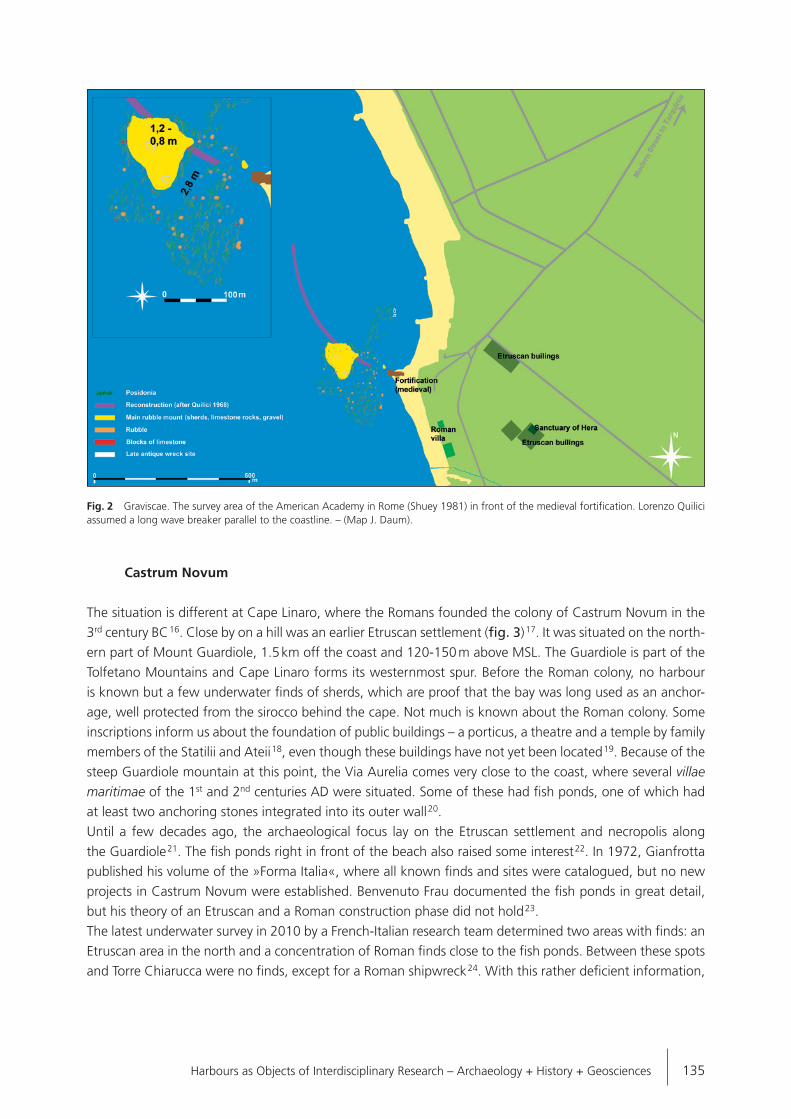
Graviscae is quite isolated. The harbour is connected to the Via Aurelia and Tarquinia. During the last 50 years, the scientific focus has been on the Greek settlement and the Temple of Hera 5, the harbour facili-ties 6 and a Roman villa maritima south of the harbour (fig. 2) 7.
134 J. Daum · Trajan’s Harbours on the Tyrrhenian Coast
A British-Italian research team conducted an underwater survey in 1971. The results show trading activi-ties until the 3rd century AD, while no remains of harbour facilities had survived the centuries 8. Yet great amounts of amphora sherds were found in the harbour area. Together with rubble and chalk they had formed a natural conglomerate too strong to reach layers older than the 1st century AD 9. Until now, it has not been possible to reconstruct the ancient harbour design. The residents from Porto Clementino reported a heavy bombardment of the harbour area in World War II and the destruction of the medieval fortification at the beach by German soldiers. The underwater survey verified these stories 10. The Roman settlement has been excavated only in a small area east of the Greek sanctuary 11. Some rectangular structures in the north that are visible in aerial photos were interpreted as a large warehouse complex by Lorenzo Quilici in 1968 12. His view was challenged by Torelli, who rather believed in Roman land plotting marks 13. The area covers about 100,000 m2 14. In none of the other ports along the Tyrrhenian coast between Mons Argentario and Minturnae, except in Portus and Ostia, have horrea of that size been recorded. In the settlement area close to the sanctuary, in insula II, a possible magazine structure has been observed 15. Graviscae had a strong orientation towards Tarquinia, as evidenced in the connection of streets, rivers and the position of the saline. There is, however, no evidence for an economic connection with Centumcellae, or for any interests to the south.
Fig. 1 Central Italy with the harbour sites discussed in this article. – (Map J. Daum).
Harbours as Objects of Interdisciplinary Research – Archaeology + History + Geosciences 135
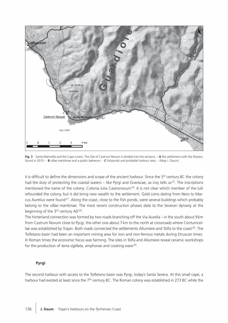
Castrum Novum
The situation is different at Cape Linaro, where the Romans founded the colony of Castrum Novum in the 3rd century BC 16. Close by on a hill was an earlier Etruscan settlement (fig. 3) 17. It was situated on the north-ern part of Mount Guardiole, 1.5 km off the coast and 120-150 m above MSL. The Guardiole is part of the Tolfetano Mountains and Cape Linaro forms its westernmost spur. Before the Roman colony, no harbour is known but a few underwater finds of sherds, which are proof that the bay was long used as an anchor-age, well protected from the sirocco behind the cape. Not much is known about the Roman colony. Some inscriptions inform us about the foundation of public buildings – a porticus, a theatre and a temple by family members of the Statilii and Ateii 18, even though these buildings have not yet been located 19. Because of the steep Guardiole mountain at this point, the Via Aurelia comes very close to the coast, where several villae maritimae of the 1st and 2nd centuries AD were situated. Some of these had fish ponds, one of which had at least two anchoring stones integrated into its outer wall 20. Until a few decades ago, the archaeological focus lay on the Etruscan settlement and necropolis along the Guardiole 21. The fish ponds right in front of the beach also raised some interest 22. In 1972, Gianfrotta published his volume of the »Forma Italia«, where all known finds and sites were catalogued, but no new projects in Castrum Novum were established. Benvenuto Frau documented the fish ponds in great detail, but his theory of an Etruscan and a Roman construction phase did not hold 23. The latest underwater survey in 2010 by a French-Italian research team determined two areas with finds: an Etruscan area in the north and a concentration of Roman finds close to the fish ponds. Between these spots and Torre Chiarucca were no finds, except for a Roman shipwreck 24. With this rather deficient information,
Fig. 2 Graviscae. The survey area of the American Academy in Rome (Shuey 1981) in front of the medieval fortification. Lorenzo Quilici assumed a long wave breaker parallel to the coastline. – (Map J. Daum).
136 J. Daum · Trajan’s Harbours on the Tyrrhenian Coast
it is difficult to define the dimensions and scope of the ancient harbour. Since the 3rd century BC the colony had the duty of protecting the coastal waters – like Pyrgi and Graviscae, as Livy tells us 25. The inscriptions mentioned the name of the colony: Colonia Iulia Castronovum 26. It is not clear which member of the Iulii refounded the colony, but it did bring new wealth to the settlement. Gold coins dating from Nero to Mar-cus Aurelius were found 27. Along the coast, close to the fish ponds, were several buildings which probably belong to the villae maritimae. The most recent construction phases date to the Severan dynasty at the beginning of the 3rd century AD 28.The hinterland connection was formed by two roads branching off the Via Aurelia – in the south about 9 km from Castrum Novum close to Pyrgi, the other one about 7 km to the north at crossroads where Centumcel-lae was established by Trajan. Both roads connected the settlements Allumiere and Tolfa to the coast 29. The Tolfetano basin had been an important mining area for iron and non-ferrous metals during Etruscan times. In Roman times the economic focus was farming. The sites in Tolfa and Allumiere reveal ceramic workshops for the production of terra sigillata, amphorae and cooking ware 30.
Pyrgi
The second harbour with access to the Tolfetano basin was Pyrgi, today’s Santa Severa. At this small cape, a harbour had existed at least since the 7th century BC. The Roman colony was established in 273 BC while the
Fig. 3 Santa Marinella and the Cape Linaro. The Site of Castrum Novum is divided into the sections. – A the settlement with the theatre, found in 2015. – B villae maritimae and a public balneum. – C fishponds and probable harbour area. – (Map J. Daum).

Harbours as Objects of Interdisciplinary Research – Archaeology + History + Geosciences 137
Roman harbour facilities date to the 1st century BC and were apparently founded on Etruscan structures 31. The shore around Pyrgi is shallow with sandy beaches with a formation of solid rock extending into the sea only where this small harbour was constructed. It is an old riverbed that was carved like a channel into the rock 32. The Etruscans used the riverbed as a harbour channel and built a small harbour basin into the south-eastern plateau (fig. 4) 33. A second harbour basin was situated between the southern corner of the Roman castrum and the area of the Etruscan temples. A constant coastal erosion is caused by wave action and cur-rents. The land ridge with a height of 1.50 m is being eroded, with the archaeological material falling to beach level. Thus the coastline is constantly moving to the north 34. This process took place as early as antiquity, as evidenced by the presence of Etruscan remains of houses or wells inside the Roman harbour basin 35. The Etruscans had already tried to protect the coastline with a breakwater. Excavations around the sanctu-ary and the castrum revealed intensive trade in iron ore through the harbour. Raw iron was exported from Tolfetano, but ore was also imported from Elba to Bracciano in the eastern hinterland 36. However, there is no archaeological evidence for such activities in Roman times, but they return in the medieval layers only 37. Just 2.5 km north of Pyrgi, the already-mentioned road to Tolfa and Allumiere branched off from the Via Aurelia, while an eastern connection to Caere and Bracciano left the Via Aurelia 5 km south of Pyrgi. An-other coastal road ran right along the shore, parallel to the Via Aurelia. From Pyrgi to the south, this street reached Alsium after 15 km. In the north, it encounters the Via Aurelia just before today’s Santa Marinella. This street was the decumanus maximus of the Roman colony Pyrgi, leaving the city through the eastern gate, but is submerged today.During the 1970s and at the beginning of the 21st century, extensive underwater surveys were conducted in the harbour area of Pyrgi. In the bigger harbour basin at the eastern corner of the castrum, a brick wall was found 38. The wall survives to a length of 70 m, but the top layers at the eastern end are today spread
Fig. 4 Pyrgi, today’s Santa Severa. – (Map J. Daum).
AdG
Texte surligné
wrong scale! "500 m" = ca. 350 m
138 J. Daum · Trajan’s Harbours on the Tyrrhenian Coast
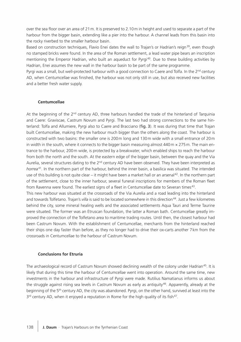
over the sea floor over an area of 21 m. It is preserved to 2.10 m in height and used to separate a part of the harbour from the bigger basin, extending like a pier into the harbour. A channel leads from this basin into the rocky riverbed to the smaller harbour basin. Based on construction techniques, Flavio Enei dates the wall to Trajan’s or Hadrian’s reign 39, even though no stamped bricks were found. In the area of the Roman settlement, a lead water pipe bears an inscription mentioning the Emperor Hadrian, who built an aqueduct for Pyrgi 40. Due to these building activities by Hadrian, Enei assumes the new wall in the harbour basin to be part of the same programme. Pyrgi was a small, but well-protected harbour with a good connection to Caere and Tolfa. In the 2nd century AD, when Centumcellae was finished, the harbour was not only still in use, but also received new facilities and a better fresh water supply.
Centumcellae
At the beginning of the 2nd century AD, three harbours handled the trade of the hinterland of Tarquinia and Caere: Graviscae, Castrum Novum and Pyrgi. The last two had strong connections to the same hin-terland: Tolfa and Allumiere, Pyrgi also to Caere and Bracciano (fig. 3). It was during that time that Trajan built Centumcellae, making the new harbour much bigger than the others along the coast. The harbour is constructed with two basins: the smaller one is 200 m long and 130 m wide with a small entrance of 20 m in width in the south, where it connects to the bigger basin measuring almost 440 m × 275 m. The main en-trance to the harbour, 200 m wide, is protected by a breakwater, which enabled ships to reach the harbour from both the north and the south. At the eastern edge of the bigger basin, between the quay and the Via Aurelia, several structures dating to the 2nd century AD have been observed. They have been interpreted as horrea 41. In the northern part of the harbour, behind the inner basin, a basilica was situated. The intended use of this building is not quite clear – it might have been a market hall or an arsenal 42. In the northern part of the settlement, close to the inner harbour, several funeral inscriptions for members of the Roman fleet from Ravenna were found. The earliest signs of a fleet in Centumcellae date to Severan times 43. This new harbour was situated at the crossroads of the Via Aurelia and a road leading into the hinterland and towards Tolfetano. Trajan’s villa is said to be located somewhere in this direction 44. Just a few kilometres behind the city, some mineral healing wells and the associated settlements Aqua Tauri and Terme Taurine were situated. The former was an Etruscan foundation, the latter a Roman bath. Centumcellae greatly im-proved the connection of the Tolfetano area to maritime trading routes. Until then, the closest harbour had been Castrum Novum. With the establishment of Centumcellae, merchants from the hinterland reached their ships one day faster than before, as they no longer had to drive their ox-carts another 7 km from the crossroads in Centumcellae to the harbour of Castrum Novum.
Conclusions for Etruria
The archaeological record of Castrum Novum showed declining wealth of the colony under Hadrian 45. It is likely that during this time the harbour of Centumcellae went into operation. Around the same time, new investments in the harbour and infrastructure of Pyrgi were made. Rutilius Namatianus informs us about the struggle against rising sea levels in Castrum Novum as early as antiquity 46. Apparently, already at the beginning of the 5th century AD, the city was abandoned. Pyrgi, on the other hand, survived at least into the 3rd century AD, when it enjoyed a reputation in Rome for the high quality of its fish 47.
Harbours as Objects of Interdisciplinary Research – Archaeology + History + Geosciences 139
In Etruria, the construction of Centumcellae had an extensive impact on the harbour network, which is mainly true for the area in the south where the interests of the merchants of Centumcellae, Castrum Novum and Pyrgi overlapped. Traders and their business drifted from Castrum Novum to the new and fast-growing Centumcellae. The harbour of Pyrgi, on the other hand, was connected to the Tolfa area in the north-east and to Caere and Bracciano in the south-east. Because of the orientation in both directions, the harbour not only survived, but was also upgraded with a new quay or mole during the first half of the 2nd century AD.
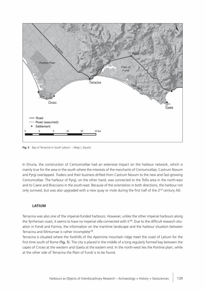
LATIUM
Terracina was also one of the imperial-funded harbours. However, unlike the other imperial harbours along the Tyrrhenian coast, it seems to have no imperial villa connected with it 48. Due to the difficult research situ-ation in Fondi and Formia, the information on the maritime landscape and the harbour situation between Terracina and Minturnae is rather incomplete 49.Terracina is situated where the foothills of the Apennine mountain ridge meet the coast of Latium for the first time south of Rome (fig. 5). The city is placed in the middle of a long regularly formed bay between the capes of Circeo at the western and Gaeta at the eastern end. In the north-west lies the Pontine plain, while at the other side of Terracina the Plain of Fundi is to be found.
Fig. 5 Bay of Terracina in South Latium. – (Map J. Daum).

140 J. Daum · Trajan’s Harbours on the Tyrrhenian Coast
Circeo
The Pontine plain is very flat with just one elevation – Monte Circeo, rising up like an island (fig. 6) 50. The hill is 5.5 km long with two peaks, the western one of which rises 541 m and the eastern one 448 m. On the eastern side of Monte Circeo, the oldest known settlement has been affirmed 51. On the western side of the hill, a harbour was located as part of an artificial channel system which connects, until today, the Mediter-ranean with Lake Paola in the immediate hinterland of the coast (fig. 7). The channel was planned under Nero and finished under Domitian 52. It had been Nero’s plan to build an inland shipping route connecting the lakes and lagoons by a waterway system that would have been independent of weather and currents, facilitating trade between Puteoli and Rome. However, this system was never completed. Two Neronian channels led around Monte Circeo 53. The Fossa Augusta passed the hill on its north side. Until the beginning of the 20th century remains of that channel existed in the eastern part. It is uncertain whether the western channel to the lake was ever finished. The smaller and much better conserved channel is the so-called harbour channel. It was built at the eastern end of the lake, close to the foot of the hill. At the seaward exit of the channel, a harbour was established by Domitian. His main interest in this project was most likely the connection of his big villa on the shore of Lake Paola to the sea, rather than the waterway to Rome 54. To this day the channel is used by local fisherman. It measures about 1 km in length with walls made of opus caementicium and a facade of opus reticulatum, opus latericium and opus mixtum. At the
Fig. 6 The Pontine Plain seen from the Acropolis of Terracina. The green line from the foot of the hill in direction of Terracina is the modern Via Appia nova. In the background on the left: Monte Circeo. – (Photo J. Daum).

Harbours as Objects of Interdisciplinary Research – Archaeology + History + Geosciences 141
seaward end, the walls extend into the sea: with the northern wall reaching c. 100 m and the southern one c. 60 m (measured from today’s shoreline). Hereby, a small harbour basin is constructed south of the channel. In his description of the walls in the 17th century, Lucas Holstenius mentions several iron rings on the wall, probably ship fastenings 55. They were lost during the repairs undertaken by Pope Innocence XIII in the 18th century. Other signs of the harbour are some building remains in the area below Torre di Paola. Among these structures, many Murex trunculus shells have been found. Other finds were terracotta lamps, dating to the late 1st or early 2nd century AD 56.A theory by Lorenzo Quilici and Stefania Quilici Gigli placed a second harbour on the eastern side of the cape. They report to have seen the harbour walls in aerial photographs 57. Today, this part of the coast is covered by the modern marina. Along the coast, several villae maritimae with fish ponds have been docu-mented. It is possible that the walls seen by the Quilicies were part of such a structure, but only fieldwork could verify this statement.In ancient sources, Cape Circeo was known for its sanctuary of Circe and was as such probably mentioned in the Homeric Odyssey 58. A harbour is mentioned only by one ancient author: Strabon described the danger-ous beachy coast south of Astura with the next harbour at Monte Circeo 59. Other than that, Circeo is men-tioned for the cultivation of fruits and vegetables, which were sold in the markets of Rome 60. The murex shells point to the production of purple dye in or near the harbour 61, which indicates surplus production and trade around Monte Circeo, especially from the 1st century AD. Nevertheless, there are no signs of a strong connection to the hinterland of the Pontine plain. Moreover, there is no evidence for a maritime economic relationship between Circeo and Terracina.
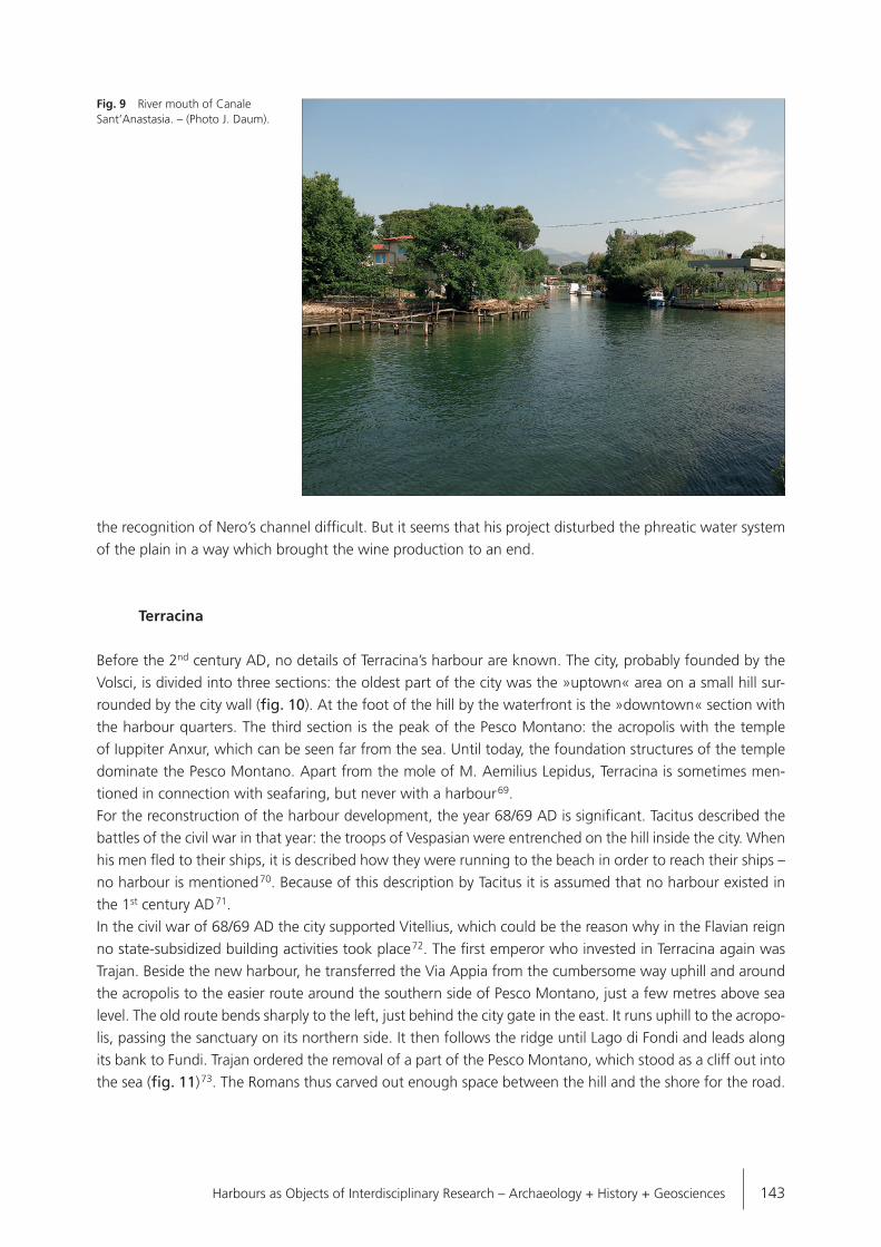
Fundi
The plain east of Terracina is much smaller than the Pontine plain. It begins behind the Pesco Montano, extending 12 km to the south-east (fig. 8). The plain is surrounded by mountains on three sides, the cae-
Fig. 7 The so-called harbour channel of Circeo. It connects the Lago di Paola with the Tyrrhenian Sea. South of the walls at the western end of the channel was a small harbour. – (Map and photo J. Daum).

142 J. Daum · Trajan’s Harbours on the Tyrrhenian Coast
cubi montes 62, while in the south the plain is bordered by the Tyrrhenian Sea. Fundi is situated close to the mountains, far away from the sea, to which it is connected by many small channels and the Lago di Fondi. This sickle-shaped lake is located on the western part of the plain and connected to the sea by channels at both ends. The Canale Canneto runs parallel to the Via Appia Traiana and meets the sea close to the hill Pesco Montano. The Canale Sant’Anastasia on the east is less straight, but deeper and wider than the west-ern channel and most likely navigable 63. The main product of the plain was wine, as several ancient authors mention the white wine caecubo 64. Also shipwrecks found in the western Mediterranean revealed a huge red wine export from Fundi to the western provinces during the 2nd and 1st centuries BC 65. The amphorae used for that wine trade were produced at the outlets of the two channels Canale Canneto and Cannale Sant’Anastasia 66.Though the latter was deep and wide enough for ships, no harbour structures have been recorded (fig. 9). Livy mentions a mole, which was built in the 2nd century BC by the senator M. Aemilius Lepidus somewhere near Fundi with public money 67. With this harbour, he enhanced the infrastructure for his villa in the area of Terracina and Fundi. The location of this mole has not been found yet. It could be a precursor of the harbour of Terracina, a harbour at the Canale Sant’Anastasia or even in a completely different place. In the 1st century AD the demographic picture changed. Many villae were abandoned and no more amphorae were produced at the channels 68. The only hint of what happened to the Plain of Fundi is given by Pliny: he explains that the caecubo was one of the finest wines until the dieback of grapes, due to want of care, shortage of space, but mostly because of the channel construction by Nero, who wanted to build a shipping channel between Puteoli and Rome. Today the plain is interspersed with drainage channels, which makes
Fig. 8 The Plain of Fundi (modern Fondi) surrounded by the Monti Ausoni. – (Map J. Daum).
arthu
Commentaire sur le texte
Livy mentions Terracina, not Fundi
Harbours as Objects of Interdisciplinary Research – Archaeology + History + Geosciences 143
the recognition of Nero’s channel difficult. But it seems that his project disturbed the phreatic water system of the plain in a way which brought the wine production to an end.
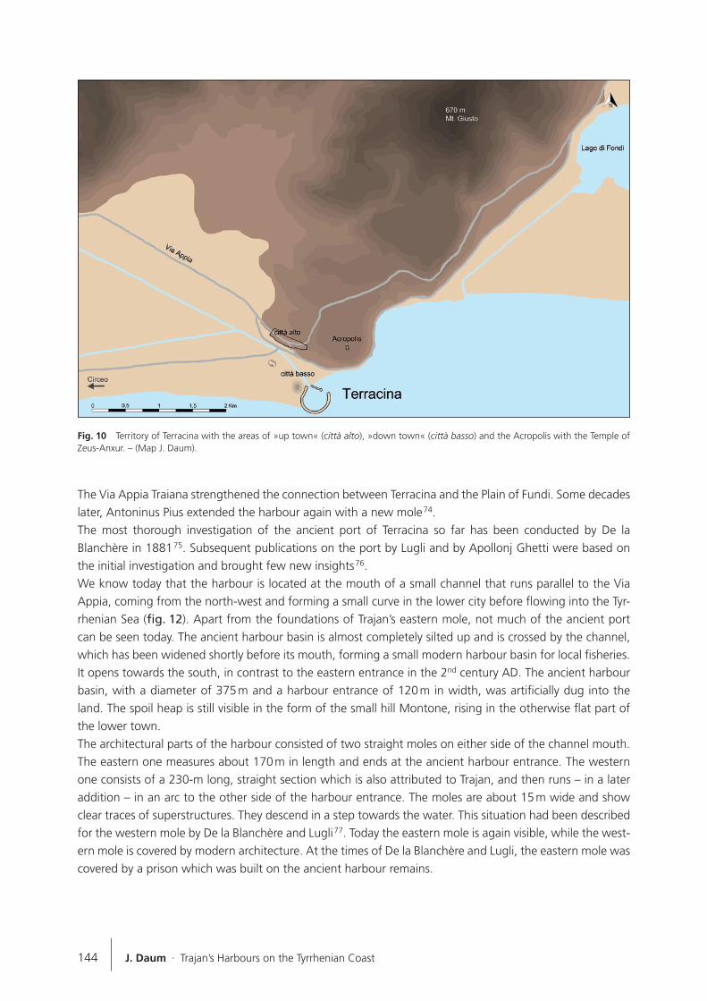
Terracina
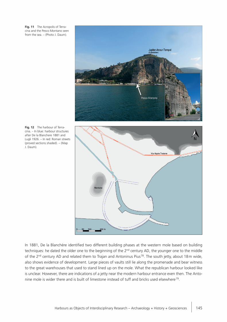
Before the 2nd century AD, no details of Terracina’s harbour are known. The city, probably founded by the Volsci, is divided into three sections: the oldest part of the city was the »uptown« area on a small hill sur-rounded by the city wall (fig. 10). At the foot of the hill by the waterfront is the »downtown« section with the harbour quarters. The third section is the peak of the Pesco Montano: the acropolis with the temple of Iuppiter Anxur, which can be seen far from the sea. Until today, the foundation structures of the temple dominate the Pesco Montano. Apart from the mole of M. Aemilius Lepidus, Terracina is sometimes men-tioned in connection with seafaring, but never with a harbour 69. For the reconstruction of the harbour development, the year 68/69 AD is significant. Tacitus described the battles of the civil war in that year: the troops of Vespasian were entrenched on the hill inside the city. When his men fled to their ships, it is described how they were running to the beach in order to reach their ships – no harbour is mentioned 70. Because of this description by Tacitus it is assumed that no harbour existed in the 1st century AD 71.In the civil war of 68/69 AD the city supported Vitellius, which could be the reason why in the Flavian reign no state-subsidized building activities took place 72. The first emperor who invested in Terracina again was Trajan. Beside the new harbour, he transferred the Via Appia from the cumbersome way uphill and around the acropolis to the easier route around the southern side of Pesco Montano, just a few metres above sea level. The old route bends sharply to the left, just behind the city gate in the east. It runs uphill to the acropo-lis, passing the sanctuary on its northern side. It then follows the ridge until Lago di Fondi and leads along its bank to Fundi. Trajan ordered the removal of a part of the Pesco Montano, which stood as a cliff out into the sea (fig. 11) 73. The Romans thus carved out enough space between the hill and the shore for the road.
Fig. 9 River mouth of Canale Sant’Anastasia. – (Photo J. Daum).
144 J. Daum · Trajan’s Harbours on the Tyrrhenian Coast
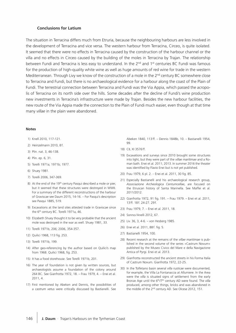
The Via Appia Traiana strengthened the connection between Terracina and the Plain of Fundi. Some decades later, Antoninus Pius extended the harbour again with a new mole 74.The most thorough investigation of the ancient port of Terracina so far has been conducted by De la Blanchère in 1881 75. Subsequent publications on the port by Lugli and by Apollonj Ghetti were based on the initial investigation and brought few new insights 76.We know today that the harbour is located at the mouth of a small channel that runs parallel to the Via Appia, coming from the north-west and forming a small curve in the lower city before flowing into the Tyr-rhenian Sea (fig. 12). Apart from the foundations of Trajan’s eastern mole, not much of the ancient port can be seen today. The ancient harbour basin is almost completely silted up and is crossed by the channel, which has been widened shortly before its mouth, forming a small modern harbour basin for local fisheries. It opens towards the south, in contrast to the eastern entrance in the 2nd century AD. The ancient harbour basin, with a diameter of 375 m and a harbour entrance of 120 m in width, was artificially dug into the land. The spoil heap is still visible in the form of the small hill Montone, rising in the otherwise flat part of the lower town. The architectural parts of the harbour consisted of two straight moles on either side of the channel mouth. The eastern one measures about 170 m in length and ends at the ancient harbour entrance. The western one consists of a 230-m long, straight section which is also attributed to Trajan, and then runs – in a later addition – in an arc to the other side of the harbour entrance. The moles are about 15 m wide and show clear traces of superstructures. They descend in a step towards the water. This situation had been described for the western mole by De la Blanchère and Lugli 77. Today the eastern mole is again visible, while the west-ern mole is covered by modern architecture. At the times of De la Blanchère and Lugli, the eastern mole was covered by a prison which was built on the ancient harbour remains.
Fig. 10 Territory of Terracina with the areas of »up town« (città alto), »down town« (città basso) and the Acropolis with the Temple of Zeus-Anxur. – (Map J. Daum).
Harbours as Objects of Interdisciplinary Research – Archaeology + History + Geosciences 145
In 1881, De la Blanchère identified two different building phases at the western mole based on building techniques: he dated the older one to the beginning of the 2nd century AD, the younger one to the middle of the 2nd century AD and related them to Trajan and Antoninus Pius 78. The south jetty, about 18 m wide, also shows evidence of development. Large pieces of vaults still lie along the promenade and bear witness to the great warehouses that used to stand lined up on the mole. What the republican harbour looked like is unclear. However, there are indications of a jetty near the modern harbour entrance even then. The Anto-nine mole is wider there and is built of limestone instead of tuff and bricks used elsewhere 79.
Fig. 11 The Acropolis of Terra-cina and the Pesco Montano seen from the sea. – (Photo J. Daum).
Fig. 12 The harbour of Terra-cina. – In blue: harbour structures after De la Blanchere 1881 and Lugli 1926. – In red: Roman streets (proved sections shaded). – (Map J. Daum).
146 J. Daum · Trajan’s Harbours on the Tyrrhenian Coast
Conclusions for Latium
The situation in Terracina differs much from Etruria, because the neighbouring harbours are less involved in the development of Terracina and vice versa. The western harbour from Terracina, Circeo, is quite isolated. It seemed that there were no effects in Terracina caused by the construction of the harbour channel or the villa and no effects in Circeo caused by the building of the moles in Terracina by Trajan. The relationship between Fundi and Terracina is less easy to understand. In the 2nd and 1st centuries BC Fundi was famous for the production of high-quality white wine as well as huge amounts of red wine for trade in the western Mediterranean. Through Livy we know of the construction of a mole in the 2nd century BC somewhere close to Terracina and Fundi, but there is no archaeological evidence for a harbour along the coast of the Plain of Fundi. The terrestrial connection between Terracina and Fundi was the Via Appia, which passed the acropo-lis of Terracina on its north side over the hills. Some decades after the decline of Fundi’s wine production new investments in Terracina’s infrastructure were made by Trajan. Besides the new harbour facilities, the new route of the Via Appia made the connection to the Plain of Fundi much easier, even though at that time many villae in the plain were abandoned.
Notes
1) Knell 2010, 117-121.
2) Heinzelmann 2010, 8 f.
3) Plin. nat. 3, 46-138.
4) Plin. ep. 6, 31.
5) Torelli 1971a; 1971b; 1977.
6) Shuey 1981.
7) Torelli 2006, 347-369.
8) At the end of the 19th century Pasqui described a mole or pier, but it seemed that these structures were destroyed in WWII. For a summary of the different reconstructions of the harbour of Graviscae see Daum 2015, 14-16. – For Pasqui’s description see Pasqui 1885, 519.
9) Excavations at the land sites attested trade in Graviscae since the 6th century BC. Torelli 1971a, 46.
10) Elizabeth Shuey thought it to be very probable that the ancient mole was destroyed in the war as well. Shuey 1981, 33.
11) Torelli 1971b, 206; 2006, 354-357.
12) Quilici 1968, 113 fig. 253.
13) Torelli 1971b, 199.
14) After geo-referencing by the author based on Quilici’s map from 1968. Quilici 1968, fig. 253.
15) It has a food storehouse. See Torelli 1971b, 201.
16) The year of foundation is not given by written sources, but archaeologists assume a foundation of the colony around 264 BC. See Gianfrotta 1972, 18. – Frau 1979, 4. – Enei et al. 2011, 4.
17) First mentioned by Abeken and Dennis, the possibilities of a castrum vetus were critically discussed by Bastianelli. See
Abeken 1840, 113 ff. – Dennis 1848b, 10. – Bastianelli 1954, 99.
18) CIL XI 3576 ff.
19) Excavations and surveys since 2010 brought some structures into light, but they were part of the villae maritimae and a Ro-man bath. Enei et al. 2011; 2013. In summer 2016 the theater was identified by Flavio Enei but is not yet published.
20) Frau 1979, 6 pl. 2. – Enei et al. 2011, 30 fig. 85.
21) Especially Bastianelli and his archaeological research group, Associazione Archeologica Centumcellae, are focused on the Etruscan history of Santa Marinella. See Maffei et al. 2011/2012.
22) Gianfrotta 1972, 91 fig. 191. – Frau 1979. – Enei et al. 2011, 13 ff. 18 f. 24-27. 29 f.
23) Frau 1979, 7. – Enei et al. 2011, 18.
24) Sonno / Anelli 2012, 67.
25) Liv. 36, 3, 4-6. – von Hesberg 1985.
26) Enei et al. 2011, 88 f. fig. 5.
27) Bastianelli 1954, 100.
28) Recent research at the remains of the villae maritimae is pub-lished in the second volume of the series »Castrum Novum« published by the Museo Civico del Mare e della Navigazione Antica of Pyrgi. Enei et al. 2013.
29) Gianfrotta reconstructed the ancient streets in his Forma Italia of Castrum Novum. Gianfrotta 1972, 22-25.
30) In the Tolfetano basin several villa rusticae were documented, for example, the Villa La Fontanaccia at Allumiere. In the Area were the villa is situated signs of settlement from the early Bronze Age until the 6th/7th century AD were found. The villa produced, among other things, bricks and was abandoned in the middle of the 2nd century AD. See Olcese 2012, 151.
Harbours as Objects of Interdisciplinary Research – Archaeology + History + Geosciences 147
31) Rovere et al. 2011, 86 f.
32) It was a promontory with a riverbed and two very small islands. See Enei 2004, 19. – Rovere et al. 2011, 83.
33) Enei 2004, 82 cat. no. 48.
34) Average coastal erosion is 3.3 cm each year. Rovere et al. 2011, 89 f.
35) Enei 2004, 27 f.
36) This trade is documented through collected surface finds be-tween Pyrgi and Bracciano. See Zifferero 1990, 73.
37) Zifferero 1990, 72.
38) In the 1970s, the southern corner of the castrum was just a small part of the survey. Oleson 1977, 307. – Enei 2004, 62.
39) Enei 2004, 62 cat. No. 3.
40) Colonna 1960, 363. – Enei 2004, 33 fig. 42.
41) In WWII 80 % of Civitavecchia was destroyed. After the war, Bastianelli described some structures, but without any plans or a thorough documentation. See Bastianelli 1954, 39-44.
42) Bastianelli 1940, 189; 1954, 44 fig. 4. – Quilici 1993, 66.
43) With the presence of the fleet, the function of the inner basin is almost clear. It is indeed not clear if the inner harbour was planned to host war ships from the beginning. No shipsheds were found in this part. Caruso mentioned navalia at the Forte Michelangelo, which are covered by modern buildings. Vgl. De Rossi 1865, 42-46. – Mengarelli 1919, 224. – Bastianelli 1940, 195; 1954, 47 f. – Caruso 1998, 36.
44) The villa of Trajan in not located yet, but its existence is proved by Pliny (ep. 6), while the location of the villa is discussed since the 19th century. See Manzi 1837, 53. – Bastianelli 1954, 61. – Torelli 1980, 115. – Correnti 1990, 209-214.
45) This theory is based on numismatic finds. There were still build-ings constructed after Hadrian. See Bastianelli 1954, 100. – Enei et al. 2011; 2013.
46) Rut. Nam. 1, 223-228.
47) Athen 6, 224c.
48) These other harbours are Centumcellae, Antium, Circeo and Gaeta. Astura is assumed to be constructed by order of Au-gustus, but is not verified. See Suet. Nero 9. – Suet. Augustus 97. – Plin. nat. 32,4. – Hist. Aug. Ant. Pius 8. – Lugli 1928. – Ciccone 1998, 16 f. note 15. – Daum 2016.
49) The archaeological focus in this area was on statues and mosa-ics. Architectural remains were almost destroyed (usually with-out documentation) after the recovery of art work. Cassieri 2000, 23. – Di Fazio 2006, 189. 197.
50) In prehistoric times, when the sea level was higher, it actually was an island.
51) In the caves at the foot of the hill Neanderthaler bones were found. The Roman colony half way up the hill is one of the oldest Roman colonies. See Grimali / Spinapolice 2010, 415.
52) The different phases of the channel are assumed in connection with the phases of the villa at the Lago. See Felici 2004, 15.
53) Lugli 1928, 31 f. 45 ff. Carta no. 2.
54) There is no evidence that Domitian finished any other of Nero’s channels.
55) Holstenius 1666, 1002 line 29.
56) Lugli describes the remains of the channel and the harbour in 1928. Felici focused on the construction of the channel walls to compare them with the harbour structures of Antium. See Lugli 1928. – Felici 1993, 93; 2004, 15.
57) Already Lugli mentioned a structure in the water, but without any closer description or dating. Quilici and Quilici Gigli as-sumed a harbour basin with a size of 9,000 m 2. He saw a wall on a photography of the British Royal Air Force. »A circa 58 m dalla linea di costa e parallela a questa si evidenza a traccia della diga foranea, chiusa a sud ovest, ove si lega a terraferma e poi protesa a nord per circa 158 m, con all’estremità una lieve rientranza.« Quilici / Quilici Gigli 2005, 131.
58) Hom. Od. 10, 149 f. 210. 275 f.
59) Strab. 5, 3, 6.
60) Plin. nat. 15,118. – Strab. 5, 3, 5-6. – Polyb. 31, 22.
61) Felici 2004, 15.
62) The caecubo was one of the finest Roman white wines. See Plin. nat. 14, 61. – Di Fazio 2006, 3.
63) The channel was navigable at least until the 9th century AD, when the so-called Saracens plundered Fondi. See Di Fazio 2006, 50.
64) Strab. 5, 3, 6. – Plin. nat. 14, 61. – Mart. 13, 113.
65) Tchernia et al. 1978, 41 f.; 1978, pl. XV, 2e_3005. – Di Fazio 2006, 54.
66) Olcese 2011/2012, 134-137.
67) The general public was not too excited about the use of their money. Liv. 40, 51, 2 f.
68) Di Fazio 2006, Map. – Olcese 2011/2012, 134 f.
69) Julius Obsequens 24. – Liv. 27, 4, 11 ff. – Liv. 36, 3, 6. – Mart. 10, 51.
70) Tac. hist. 3, 77.
71) Lugli 1926, XVII.
72) Tac. hist. 4, 3.
73) There is no distinct evidence for Trajan’s orders, but he is men-tioned as the restorer of the Via Appia at several cippi. CIL X 6819 – 6853. – Lugli 1926, 210 ff.
74) Hist. Aug. Ant. Pius 8.
75) De la Blanchère 1881.
76) Lugli summarised De la Blanchère briefly, but disagreed with his reconstruction. Apollonj Ghetti repeated Lugli. See Lugli 1926, 126-132. – Apollonj Ghetti 1972a; 1972b.
77) Lugli 1926, 132. – De la Blanchère 1881, 335.
78) Lugli 1926, 128.
79) De la Blanchère 1881, 336.
80) Athen. 6, 224c.
81) Bastianelli 1954, 15.
82) The relationship between Fundi and Terracina, especially of their harbours, could be explained after the localization of the harbour of Fundi and a reconstruction of the environmental
148 J. Daum · Trajan’s Harbours on the Tyrrhenian Coast
development of the plain of Fundi in the 1st century AD, when
the channel of Nero was built.
83) That is what Tacitus assumed. Tac. Hist. 4, 3.
84) Plin. ep. 6, 31.
Sources
Athenaeus Deipnsophistae: C. B. Gulick, Athenaeus. The Deipno-sophists, in seven volumes, 7 (London, Cambridge MA 1970).
Historiae Augustae: D. Magie, The Scriptores Historiae Augustae, in three volumes, 1 (London, Cambridge MA 1967).
Homer: J. H. Voss / H. Rupé / E. R. Weiß / B. Genelli, Homer. Illias und Odyssee (Köln 2000).
Livius Book XXVII-XXX: H. J. Hillen, T. Livius. Römische Geschichte Buch XXVII-XXX, Lateinisch – Deutsch, Sammlung Tusculum (Düsseldorf, Zürich 1997).
Livius Book XXXV-XXXVIII: H. J. Hillen, T. Livius. Römische Ge-schichte Buch XXXV-XXXVIII, Lateinisch – Deutsch, Sammlung Tusculum (Düsseldorf, Zürich 31998).
Livius Book XXXIX-XLI: H. J. Hillen, T. Livius. Römische Geschichte Buch XXXIX-XLI, Lateinisch – Deutsch, Sammlung Tusculum (Düsseldorf, Zürich 32007).
Martial: P. Barié / W. Schindler, M. Valerius Martialis. Epigramme, Lateinisch – Deutsch, Sammlung Tusculum (Berlin 32013).
Plinius nat. Book III: G. Winkler / R. König, C. Plinius Secundus d. Ä. Naturkunde Buch III-IV Geographie: Europa, Lateinisch – Deutsch, Sammlung Tusculum (Düsseldorf, Zürich 22002).
Plinius nat. Book XIV–XV: G. Winkler / R. König, C. Plinius Secun-dus d. Ä. Naturkunde Buch XIV–XV Botanik: Fruchtbäume, Latei-nisch – Deutsch, Sammlung Tusculum (München 1981).
Plinius nat. Book XXXII: R. König / J. Hopp / W. Glöckner, C. Plinius Secundus d. Ä. Naturkunde Buch XXXII Medizin und Pharmako-lie: Heilmittel aus dem Wasser, Lateinisch – Deutsch, Sammlung Tusculum (Zürich 1995).
Plinius ep.: H. Kasten, Gaius Plinius Caecilius Secundus. Briefe, Epi-stularum Libri Decem, Lateinisch – Deutsch, Sammlung Tusculum (Düsseldorf, Zürich 82003).
Polybios Buch XI-XXXIX: H. Drexler, Polybios. Geschichte, Gesamt-ausgabe in zwei Bänden, 2 (Stuttgart, Zürich 1963).
Rut. Nam.: E. Doblhofer, Rutilius Namatianus, De reditu suo sive iter Gallicum, Lateinisch – Deutsch (Heidelberg 1972).
Strabo: S. Radt, Strabons Geographika 2, Buch V-VIII: Text und Übersetzung (Göttingen 2003).
Sueton: H. Martinet, C. Suetonius Tranquillus. Die Kaiserviten, De Vita Caesarum – Berühmte Manner, De Viris Illustribus, Latei-nisch – Deutsch, Tusculum (Düsseldorf 32006).
Tacitus hist.: J. Borst / H. Borst / H. Hross, P. Cornelius Tacitus. His-torien, Historiae, Lateinisch – Deutsch, Tusculum (Mannheim 72010).
References
Abeken 1840: G. Abeken, Scavi di S. Marinella. Bullettino dell’Insti-tuto di Corrispondenza Archeologica 1840, 113-115.
Apollonj Ghetti 1972a: F. M. Apollonj Ghetti, Il porto romano di Terracina e il suo auspicabile ripristino. L’Urbe 35/5, 1972, 6-11.
1972b: F. M. Apollonj Ghetti, Il porto romano di Terracina e il suo auspicabile ripristino [2]. L’Urbe 35/6, 1972, 1-9.
Bastianelli 1940: S. Bastianelli, Civitavecchia. Rinvenimenti nell’area della città. Notizie degli Scavi di Antichità 1940, 183-198.
1954: S. Bastianelli, Centumcellae (Civitavecchia), Castrum No-vum (Torre Chiarucca) Regio VII, Etruria (Roma 1954).
Caruso 1998: I. Caruso, Traiano, Plinio ed il Porto di Centumcellae.Rivista di cultura classica e medioevale 40/1-2, 1998, 33-40.
Cassieri 2000: N. Cassieri, Contributi d´Archivio alla topografia di formia romana. In: N. Cassieri (ed.), Atti del convegno di studi sui giacimenti culturali del Lazio meridionale 5, 1997 (Marina di Minturno 2000) 13-25.
Ciccone 1998: S. Ciccone, Piscinae in Litore Formiano. In: S. Ciccone (ed.), Atti del Convegno di Studi sull’antico territorio di Formia, 1996, Formia, Formianum 4 (Marina di Minturno 1998) 13-30.
Colonna 1960: G. Colonna, Santa Severa (Roma), Fistula iscritta da Pyrgi. Notizie degli Scavi di Antichità 1960, 363.
Correnti 1990: F. Correnti, Centumcellae: la villa, il porto e la città. In: A. Maffei / F. Nastasi (eds), Caere e il suo territorio da Agylla a Centumcellae (Roma 1990) 209-214.
Daum 2015: J. Daum, Hafenbau an der Küste des südlichen Etru-rien. In: Th. Schmidts / M. M. Vučetić (eds), Häfen im 1. Mil-lennium AD. Bauliche Konzepte, herrschaftliche und religiöse Einflüsse. RGZM – Tagungen 22 = Interdisziplinäre Forschungen zu den Häfen von der Römischen Kaiserzeit bis zum Mittelalter in Europa 1 (Mainz 2015) 9-22.
2016: J. Daum, Effizienz und Konkurrenz. Funktionale Beschaf-fenheit von italischen Hafenstädten und ihren Anlagen in der mittleren römischen Kaiserzeit [Diss. Univ. Hamburg 2016, Mik-rofiche].
Dennis 1848: G. Dennis, The Cities and Cemeteries of Etruria 2 (London 1848).
de la Blanchère 1881: R. de la Blanchère, Le port de Terracine. Histoire et archéologie. Mélanges d’archéologie et d’histoire de l’École française de Rome 1, 1881, 332-348.
Harbours as Objects of Interdisciplinary Research – Archaeology + History + Geosciences 149
De Rossi 1865: G. B. De Rossi, Sepolcreto scoperto in Civitavecchia. Bullettino dell’Instituto di Corrispondenza Archeologica 1865, 42-46.
Di Fazio 2006: M. Di Fazio, Fondi ed il suo territorio in età romana. Profilio di storia economica e sociale (Oxford 2006).
Enei 2004: F. Enei, Pyrgi Sommersa, Ricognizioni archeologiche su-bacquee nel porto dell’antica Caere (Santa Severa 2004).
Enei et al. 2011: F. Enei / M.-L. Haack / S. Nardi Combescure / G. Poccardi (eds), Castrum Novum. Storia ed Archeologia di una Colonia Romana nel Territorio di Santa Marinella, Quaderno 1 (Santa Marinella 2011).
2013: F. Enei / M.-L. Haack / S. Nardi Combescure / G. Poccardi (eds), Castrum Novum. Storia ed Archeologia di una Colonia Ro-mana nel Territorio di Santa Marinella, Quaderno 2 (Santa Mari-nella 2013).
Felici 1993: E. Felici, Osservazioni sul porto neroniano di Anzio e sulla tecnica romana delle costruzioni portuali in calcestruzzo. L'archeologo subacqueo 1, 1993, 71-104.
2004: E. Felici, Il Parco nazionale del Circeo: archeologia in uno straordinario paesaggio. L'archeologo subacqueo 10/1, 2004, 9-18.
Frau 1979: B. Frau, Il Ritrovamento di un Porto Etrusco del V sec. a. C. ed una Piscina Romana del I sec. a. C. nell’area marittima di Castrum Novum (Santa Marinella) (Roma 1979).
Gianfrotta 1972: P. A. Gianfrotta, Castrum Novum, Forma Italia Re-gio VII, 3 (Roma 1972).
Grimali / Spinapolice 2010: S. Grimaldi / E. Spinapolice, The Late Mousterian of the Grotta Breuil (Monte Circeo, Lazio, Italy). In-terpreting new and ancient data. In: J. M. Burdukiewicz (ed.), Middle palaeolithic human activity and palaeoecology, new dis-coveries and ideas (Wrocław 2010) 413-423.
Heinzelmann 2010: M. Heinzelmann, Supplier of Rome or Mediter-ranean marketplace? The Changing Economic Role of Ostia after the Construction of Portus in the Light of new Archaeological Evidence. In: M. Dalla Riva (ed.), Roma 2008 – International Con-gress of Classical Archaeology. Meetings between the Cultures in Ancient Mediterranean, Proceedings of the 17th International Congress of Classical Archaeology, Rome 22-26 sept. 2008. Bol-lettino di Archaeologia on line 1 Vol. Speciale, 2010, 5-10.
von Hesberg 1985: H. von Hesberg, Zur Plangestaltung der Co-loniae maritimae. Mitteilungen des Deutschen Archäologischen Instituts, Römische Abteilung 92, 1985, 127-150.
Holstenius 1666: L. Holstenii, Annotationes in geographiam Caroli à S. Paulo, Italiam Antiquam Cluverii et Thesarum geographicum Ortelii […] (Roma 1666).
Knell 2010: H. Knell, Kaiser Trajan als Bauherr. Macht und Herr-schaftsarchitektur (Darmstadt 2010).
Lugli 1926: G. Lugli, Anxur – Terracina. Forma Italia, Regio I, 1, 1 (Roma 1926).
1928: G. Lugli, Circeii, Forma Italia, Regio I, 1, 2 (Roma 1928).
Maffei et al. 2012: A. Maffei / M. Sonno / S. Anelli (eds), Cento anni di ricerche per la ricostruzio-ne dei »Paesaggi Culturali« e per la redazione della carta archeologica dell’Arco del Mignone Civitavecchia 1911-2011 (Civitavecchia 2011-2012).
Manzi 1837: P. Manzi, Stato antico ed attuale del porto città e pro-vincia di Civitavecchia (Prato 1837).
Mengarelli 1919: R. Mengarelli, Civitavecchia. Scavi eseguiti nelle »Terme Taurine« nel territorio di Civitavecchia. Notizie degli Scavi di Antichità 1919, 209-231.
Olcese 2011/2012: G. Olcese, Atlante dei siti di produzione cera-mica (Toscana, Lazio, Campania e Sicilia) con le tabelle dei princi-pali relitti del Mediterraneo occidentale con carichi dall’Italia cen-tro meridionale. IV secolo a. C.-I secolo d. C. (Roma 2011/2012).
Oleson 1977: J. P. Oleson, Underwater Survey and Excavations in the Port of Pyrgi (Santa Severa) 1974. Journal of Field Archaeol-ogy 4/3, 1977, 297-308.
Pasqui 1885: A. Pasqui, Corneto-Tarquinia. Notizie degli Scavi di Antichità 1885, 437-473. 505-524.
Quilici 1968: L. Quilici, Graviscae. In: La Via Aurelia da Roma a Fo-rum Aureli. Quaderni di Topografia Antica 4 (Roma 1968) 107-120.
1993: L. Quilici, Il Porto di Civitavecchia – L’antica Centumcellae. In: F. E. Brown / R. T. Scott / A. R. Scott (eds), Eius Virtutis Studiosi: Classical and Post Classical Studies in Memory of Frank Edward Brown (1908-1988). Studies in the History of Art 43, Symposium Papers 23 (Washington, D.C. 1993) 63-83.
Quilici / Quilici Gigli 2005: L. Quilici / S. Quilici Gigli, La Cosidetta Acropoli del Circeo. Per una lettura nel contesto topografico. In: L. Quilici / S. Quilici Gigli (eds), Forma della città e del territorio. Atlante tematico di topografia antica rivista 14 (Roma 2005) 91-146.
Rovere et al. 2011: A. Rovere / F. Antonioli / F. Enei / S. Giorgi, Rel-ative sea level change at the archaeological site of Pyrgi (Santa Severa, Rome) during the last seven millennia. Quaternary Inter-national 232, 2011, 82-91.
Shuey 1981: E. Shuey, Underwater survey and excavation at Gravisca, the port of Tarquinia. Papers of the British School at Rome 49, 1981, 17-45.
Sonno / Anelli 2012: M. Sonno / S. Anelli, Cento anni di ricerche per la ricostruzione dei »paesaggi culturali« e per la redazione della carta archeologica dell’arco del Mignone: Rinvenimenti sot-tomarini nel comprensorio di Civitavecchia, a ricerca subacquea, Civitavecchia, 1911-2011 (Civitavecchia 2012).
Tchernia et al. 1978: A. Tchernia / P. Pomey / A. Hesnard, L’Épave Romaine dela Madrague de Giens (Var). Campagnes 1972-1975 (Paris 1978).
Torelli 1971a: M. Torelli, Il santuario di Hera a Graviscae. La Parola del Passato 26, 1971, 44-67.
1971b: M. Torelli, Gravisca (Tarquinia). Scavi nella città etrusca e romana. Campagne 1969 e 1970. Notizie degli Scavi di Antichità 1971, 195-241.
1977: M. Torelli, Il Santuario greco di Gravisca. La Parola del Pas-sato 32, 1977, 398-458.
1980: M. Torelli, Etruria (Roma 1980).
2006: M. Torelli, Due Ritratti greci, una villa marittima e le coste di Graviscae. In: M. Bonghi Jovino (ed.), Tarquinia e le civiltà del Mediterraneo, Convegno internazionale Milano, 22-24 giugno 2004 (Milano 2006) 347-369.
Zifferero 1990: A. Zifferero, Insediamenti ed economia: appunti sulle risorse minerarie die monti della Tolfa. In: A. Maffei / F. Na-stasi (eds), Caere e il suo territorio da Agylla a Centumcellae (Roma 1990) 71-75.
150 J. Daum · Trajan’s Harbours on the Tyrrhenian Coast
Summary
The two examples discussed here, Centumcellae and Terracina, show a contrasting picture of harbour landscapes. For the north, Pliny the Younger emphasized the necessity of the new harbour on this harbourless coast, but after a closer look we have seen that several harbours existed there already. Until the construction of Centumcellae, the trade was handled through the other harbours close by – mainly Castrum Novum and Pyrgi. The nearby Castrum Novum declined after the construction of Centumcellae. The other two harbours, Pyrgi and Graviscae were in use at least until the 3rd century AD. The youngest sherds found in Graviscae were from that time and the last mention in written sources of a harbour in Pyrgi was from the 3rd century as well 80. Both harbours had good connections to the hinterland. In the north no evidence for any overlays of the hinterland use can be found. Graviscae was connected to Tarquinia and Centumcellae to the Tolfetano basin. Pyrgi in the south of Centumcellae had a connection to the Tolfetano basin, and to Caere and Bracciano as well. The only harbour which shared the same hinterland as Centumcellae was Castrum Novum. The reasons for the new harbour in Etruria have not been identified yet. Bastianelli assumed that Portus at the Tiber mouth was silting up and Trajan built Centumcellae to relieve Portus 81. In my opinion this is not very probable. If Portus had a silting problem, Trajan would not built two big harbours at the same time. The only connection of Trajan with Centumcellae was his villa. In Latium the situation is different. Trajan had no known personal connection with Terracina or its hinterland. The nau-tical needs were covered by the as of yet undiscovered harbour of Fundi until the middle of the 1st century AD. After the decline of the Plain of Fundi and its assumed harbour there was no harbour from the middle of the 1st century AD until the beginning of the 2nd century AD 82. So it can be assumed that in this case the harbour along the coast was a necessity. Between the reigns of Nero and Trajan the region of Terracina was ignored by the Flavian emperors because of its role in the Civil War in 68/69 AD 83. Based on the Arch of Benevent, the cippi along the road and the written sources, Trajan’s main interest was probably the Via Appia but in contrast to the situation in Etruria »[…] nam per longissimum spatium litus importuosum hoc receptaculo utetur« 84.
AUS DER REIHE / FURTHER READING
Thomas Schmidts · Martin Marko Vučetič (Hrsg.)
Häfen im 1. Millennium ADBauliche Konzepte, herrschaftliche und religiöse Einflüsse
Interdisziplinäre Forschungen zu den Häfen von der Römischen Kaiserzeit bis zum Mittel alter in Europa, Band 1
Das DFG-Schwerpunktprogramm »Häfen von der Römischen Kaiserzeit bis zum Mittelalter – Zur Archäologie und Geschichte regionaler und überregionaler Verkehrssysteme« (SPP 1630) widmet sich unter verschiedensten Aspekten der Erforschung von Häfen als Schnittstellen zwischen Wasser- und Landweg. 19 Beiträge, die auf einer Plenartagung 2014 gehalten wurden, füllen einen geographisch weit gespannten Rahmen, der vom Nordatlantik bis in den östlichen Mittelmeerraum reicht. Breiten Raum nehmen dabei Ergebnisse der häufig in enger Zusammenarbeit mit naturwissenschaftlichen Disziplinen an-gelegten Feldforschungen ein. Eine Besonderheit liegt in der Zusammenschau von Arbeiten aus unterschiedlichen historischen, archäologischen und natur-wissenschaftlichen Disziplinen.
RGZM – Tagungen, Band 22354 S., 242 meist farbige Abb.
Mainz 2015ISBN 978-3-88467-249-5
€ 52,– [D]
Verlag des Römisch-Germanischen Zentralmuseums, Mainz
Ernst-Ludwig-Platz 2 · 55116 Mainz · Tel. 0 61 31 / 91 24-0 · Fax 0 61 31 / 91 24-199
E-Mail: [email protected] · Internet: www.rgzm.de · http://shop.rgzm.de
Johannes Preiser-Kapeller · Falko Daim (eds)
Harbours and Maritime Networks as Complex Adaptive Systems
Interdisziplinäre Forschungen zu den Häfen von der Römischen Kaiserzeit bis zum Mittel alter in Europa, Band 2
The concept of complex systems allows for a better understanding of the interplay between social and environmental factors for the emergence and maintenance of maritime infrastructure and route systems in the ancient and medieval period.Complexity theory and network analysis provide an analytical framework to describe social configurations (cities, maritime communities, polities) and envi-ronmental phenomena (hydrosphere, climate) as complex systems, entangled via mechanisms of feedbacks, adaptation or disruption. In this volume, this approach is applied on various phenomena of maritime history as discussed within the DFG-funded Special Research Programme (SPP 1630) »Harbours from the Roman Period to the Middle Ages« (www.spp-haefen.de).
RGZM – Tagungen, Band 23152 S., 76 meist farbige Abb.
Mainz 2015ISBN 978-3-88467-248-8
€ 32,– [D]
AUS DER REIHE / FURTHER READING
Verlag des Römisch-Germanischen Zentralmuseums, Mainz
Ernst-Ludwig-Platz 2 · 55116 Mainz · Tel. 0 61 31 / 91 24-0 · Fax 0 61 31 / 91 24-199
E-Mail: [email protected] · Internet: www.rgzm.de · http://shop.rgzm.de
Sven Kalmring · Lukas Werther (Hrsg.)
Häfen im 1. Millennium ADStandortbedingungen, Entwicklungsmodelle und ökonomische Vernetzung
Interdisziplinäre Forschungen zu den Häfen von der Römischen Kaiserzeit bis zum Mittel alter in Europa, Band 3
Das DFG-Schwerpunktprogramm »Häfen der Römischen Kaiserzeit bis zum Mittelalter – Zur Archäologie und Geschichte regionaler und überregiona-ler Verkehrssysteme« (SPP 1630) widmet sich der Erforschung von Häfen als Schnittstellen zwischen dem Wasser- und Landweg unter verschiedensten As-pekten.Der Band versammelt 13 Beiträge, die 2015 im Rahmen einer Plenartagung gehalten wurden. Der geographisch weit gespannte Rahmen reicht vom Nord-atlantik bis in den östlichen Mittelmeerraum. Thematisiert werden See- und Binnenhäfen sowie künstliche Wasserstraßen. Der Band vereint Ergebnisse in-terdisziplinärer (geo-)archäologischer und geophysikalischer Feldforschungen, schriftquellenbasierter Untersuchungen und überregionaler Studien.
RGZM – Tagungen, Band 31251 S., 122 meist farbige Abb.
Mainz 2017ISBN 978-3-88467-283-9
€ 46,– [D]