SONNE - ldf.uni-hamburg.de · gelangen. In einem bislang einziggen arti Forschungsansatz sollen...
42
Forschungsschiff SONNE Reisen Nr. SO263 – SO265 01. 06. 2018 – 10. 10. 2018 Magmatische Entwicklung der Kruste von Inselbögen und Back-arcs und Implikationen für hydrothermale Austritte im NE Tonga Inselbogen SONNE-EMPEROR Die Plio/Pleistozäne bis Holozäne Entwicklung des pelagischen Nordpazifiks von der Oberfläche bis zum Meeresboden – Abschätzung seiner Rolle für die globale Kohlenstoffbilanz und das Erdklima SHATSKY EVOLUTION Entwicklung des Shatsky-Rise Hotspotsystems Herausgeber Institut für Geologie Universität Hamburg Leitstelle Deutsche Forschungsschiffe http://www.ldf.uni-hamburg.de Gefördert durch Bundesministerium für Bildung und Forschung (BMBF) ISSN 2364-3692
Transcript of SONNE - ldf.uni-hamburg.de · gelangen. In einem bislang einziggen arti Forschungsansatz sollen...
Forschungsschiff
SONNE
Reisen Nr. SO263 – SO265
01. 06. 2018 – 10. 10. 2018
Magmatische Entwicklung der Kruste von Inselbögen und Back-arcs und Implikationen für hydrothermale Austritte im NE Tonga Inselbogen
SONNE-EMPEROR Die Plio/Pleistozäne bis Holozäne Entwicklung des pelagischen
Nordpazifiks von der Oberfläche bis zum Meeresboden – Abschätzung seiner Rolle für die globale Kohlenstoffbilanz und das Erdklima
SHATSKY EVOLUTION Entwicklung des Shatsky-Rise Hotspotsystems
Herausgeber
Institut für Geologie Universität Hamburg Leitstelle Deutsche Forschungsschiffe
http://www.ldf.uni-hamburg.de
Gefördert durch
Bundesministerium für Bildung und Forschung (BMBF)
ISSN 2364-3692
Forschungsschiff / Research Vessel
SONNE
Reisen / Cruises Nr. / No. SO263 – SO265
01. 06. 2018 – 10. 10. 2018
Magmatische Entwicklung der Kruste von Inselbögen und Back-arcs und Im-plikationen für hydrothermale Austritte im NE Tonga Inselbogen
Magmatic evolution of island arc and back-arc crust and implications for hydro-thermal venting in the NE Tonga arc
SONNE-EMPEROR Die Plio/Pleistozäne bis Holozäne Entwicklung des pelagischen
Nordpazifiks von der Oberfläche bis zum Meeresboden – Abschätzung seiner Rolle für die globale Kohlenstoffbilanz und das Erdklima
The Plio/Pleistocene to Holocene development of the pelagic North Pacific from surface to depth –
Assessing its role for the global carbon budget and Earth´s climate
SHATSKY EVOLUTION Entwicklung des Shatsky-Rise Hotspotsystems
Evolution of the Shatsky Rise Hotspot System Herausgeber / Editor:
Institut für Geologie Universität Hamburg Leitstelle Deutsche Forschungsschiffe
http://www.ldf.uni-hamburg.de
Gefördert durch / Sponsored by: Bundesministerium für Bildung und Forschung (BMBF)
ISSN 2364-3692

Anschriften / Addresses
Prof. Dr. Karsten Haase Telefon: 09131-8522616 GeoZentrum Nordbayern Telefax: 09131-8529295 Universität Erlangen-Nürnberg e-mail: [email protected] Schloßgarten 5 D-91054 Erlangen
Prof. Dr. Dirk Nürnberg Telefon: +49-431-600-2313 GEOMAR Helmholtz-Zentrum Telefax: +49-431-600-2925 für Ozeanforschung Kiel e-mail: [email protected] Wischhofsstr. 1-3 D-24148 Kiel
PD Dr. Jörg Geldmacher Telefon: +49-431-600-2260 GEOMAR Helmholtz-Zentrum Telefax: +49-431-600-2924 für Ozeanforschung Kiel e-mail: [email protected] Wischhofsstr. 1-3 D-24148 Kiel
Leitstelle Deutsche Forschungsschiffe Telefon: +49-40-428-38-3640 Institut für Geologie Telefax: +49-40-428-38-4644 Universität Hamburg e-mail: [email protected] Bundesstraße 55 http: www.ldf.uni-hamburg.de D-20146 Hamburg
Reederei Briese Schiffahrts GmbH & Co. KG Telefon: +49 491 92520 160 Abt. Forschungsschifffahrt Telefax +49 491 92520 169 Hafenstrasse 6d (Haus Singapore) e-mail: [email protected] 26789 Leer http: www.briese.de
Projektträger Jülich Telefon: +49-0381-20356-291 System Erde - Meeresforschung e-mail: [email protected] Schweriner Straße 44 http: www.ptj.de/rostock 18069 Rostock
Forschungsschiff / Research Vessel SONNE
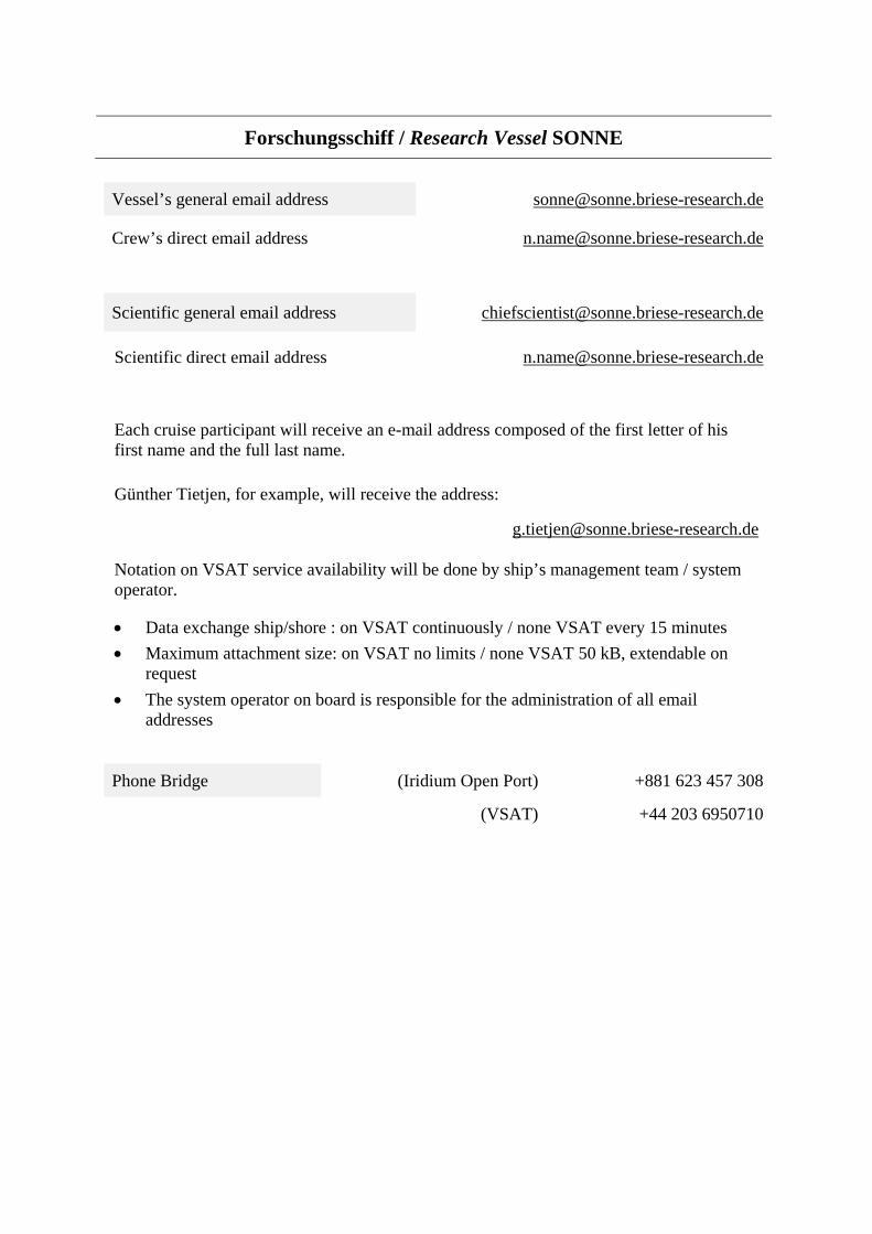
Vessel’s general email address [email protected]
Crew’s direct email address [email protected]
Scientific general email address [email protected]
Scientific direct email address [email protected]
Each cruise participant will receive an e-mail address composed of the first letter of his first name and the full last name.
Günther Tietjen, for example, will receive the address:
Notation on VSAT service availability will be done by ship’s management team / system operator.
• Data exchange ship/shore : on VSAT continuously / none VSAT every 15 minutes• Maximum attachment size: on VSAT no limits / none VSAT 50 kB, extendable on
request• The system operator on board is responsible for the administration of all email
addresses
Phone Bridge (Iridium Open Port) +881 623 457 308
(VSAT) +44 203 6950710
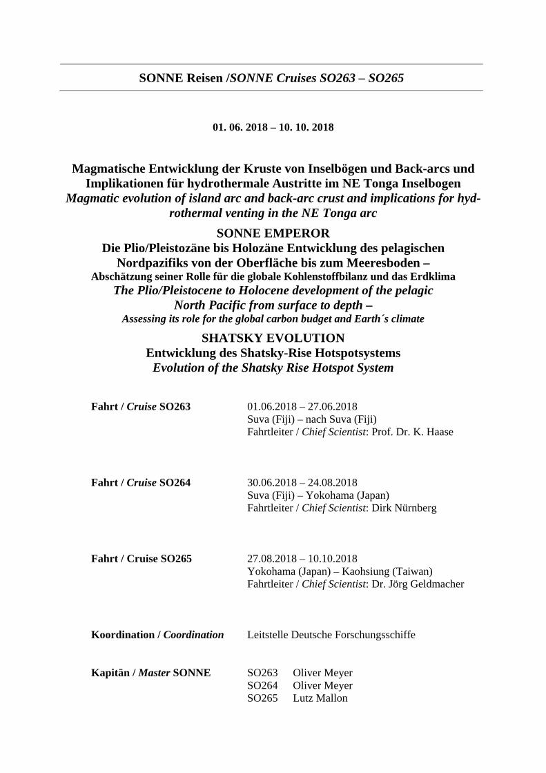
SONNE Reisen /SONNE Cruises SO263 – SO265
01. 06. 2018 – 10. 10. 2018
Magmatische Entwicklung der Kruste von Inselbögen und Back-arcs und Implikationen für hydrothermale Austritte im NE Tonga Inselbogen
Magmatic evolution of island arc and back-arc crust and implications for hyd-rothermal venting in the NE Tonga arc
SONNE EMPEROR Die Plio/Pleistozäne bis Holozäne Entwicklung des pelagischen
Nordpazifiks von der Oberfläche bis zum Meeresboden – Abschätzung seiner Rolle für die globale Kohlenstoffbilanz und das Erdklima
The Plio/Pleistocene to Holocene development of the pelagic North Pacific from surface to depth –
Assessing its role for the global carbon budget and Earth´s climate
SHATSKY EVOLUTION Entwicklung des Shatsky-Rise Hotspotsystems
Evolution of the Shatsky Rise Hotspot System
Fahrt / Cruise SO263 01.06.2018 – 27.06.2018 Suva (Fiji) – nach Suva (Fiji) Fahrtleiter / Chief Scientist: Prof. Dr. K. Haase
Fahrt / Cruise SO264 30.06.2018 – 24.08.2018 Suva (Fiji) – Yokohama (Japan) Fahrtleiter / Chief Scientist: Dirk Nürnberg
Fahrt / Cruise SO265 27.08.2018 – 10.10.2018 Yokohama (Japan) – Kaohsiung (Taiwan)Fahrtleiter / Chief Scientist: Dr. Jörg Geldmacher
Koordination / Coordination Leitstelle Deutsche Forschungsschiffe
Kapitän / Master SONNE SO263 Oliver Meyer SO264 Oliver Meyer SO265 Lutz Mallon
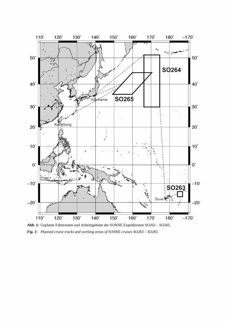
Abb. 1: Geplante Fahrtrouten und Arbeitsgebiete der SONNE Expeditionen SO263 – SO265.
Fig. 1: Planned cruise tracks and working areas of SONNE cruises SO263 – SO265.
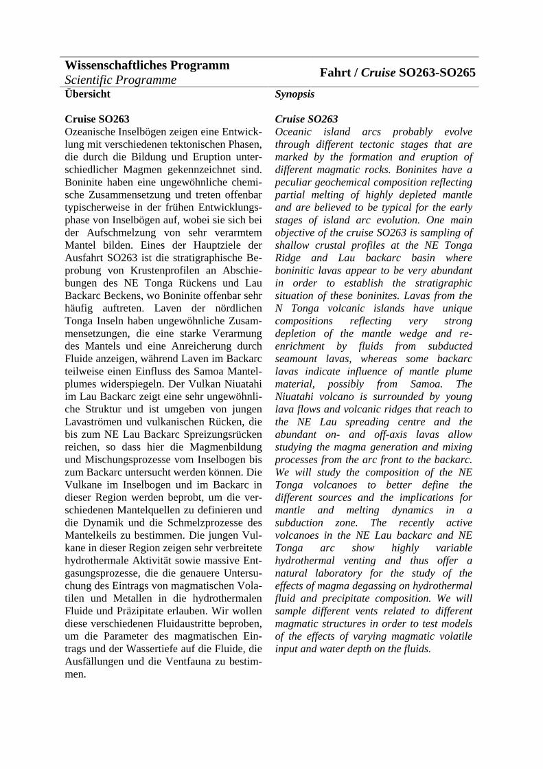
Wissenschaftliches Programm Scientific Programme Fahrt / Cruise SO263-SO265 Übersicht
Cruise SO263 Ozeanische Inselbögen zeigen eine Entwick-lung mit verschiedenen tektonischen Phasen, die durch die Bildung und Eruption unter-schiedlicher Magmen gekennzeichnet sind. Boninite haben eine ungewöhnliche chemi-sche Zusammensetzung und treten offenbar typischerweise in der frühen Entwicklungs-phase von Inselbögen auf, wobei sie sich bei der Aufschmelzung von sehr verarmtem Mantel bilden. Eines der Hauptziele der Ausfahrt SO263 ist die stratigraphische Be-probung von Krustenprofilen an Abschie-bungen des NE Tonga Rückens und Lau Backarc Beckens, wo Boninite offenbar sehr häufig auftreten. Laven der nördlichen Tonga Inseln haben ungewöhnliche Zusam-mensetzungen, die eine starke Verarmung des Mantels und eine Anreicherung durch Fluide anzeigen, während Laven im Backarc teilweise einen Einfluss des Samoa Mantel-plumes widerspiegeln. Der Vulkan Niuatahi im Lau Backarc zeigt eine sehr ungewöhnli-che Struktur und ist umgeben von jungen Lavaströmen und vulkanischen Rücken, die bis zum NE Lau Backarc Spreizungsrücken reichen, so dass hier die Magmenbildung und Mischungsprozesse vom Inselbogen bis zum Backarc untersucht werden können. Die Vulkane im Inselbogen und im Backarc in dieser Region werden beprobt, um die ver-schiedenen Mantelquellen zu definieren und die Dynamik und die Schmelzprozesse des Mantelkeils zu bestimmen. Die jungen Vul-kane in dieser Region zeigen sehr verbreitete hydrothermale Aktivität sowie massive Ent-gasungsprozesse, die die genauere Untersu-chung des Eintrags von magmatischen Vola-tilen und Metallen in die hydrothermalen Fluide und Präzipitate erlauben. Wir wollen diese verschiedenen Fluidaustritte beproben, um die Parameter des magmatischen Ein-trags und der Wassertiefe auf die Fluide, die Ausfällungen und die Ventfauna zu bestim-men.
Synopsis
Cruise SO263 Oceanic island arcs probably evolve through different tectonic stages that are marked by the formation and eruption of different magmatic rocks. Boninites have a peculiar geochemical composition reflecting partial melting of highly depleted mantle and are believed to be typical for the early stages of island arc evolution. One main objective of the cruise SO263 is sampling of shallow crustal profiles at the NE Tonga Ridge and Lau backarc basin where boninitic lavas appear to be very abundant in order to establish the stratigraphic situation of these boninites. Lavas from the N Tonga volcanic islands have unique compositions reflecting very strong depletion of the mantle wedge and re-enrichment by fluids from subducted seamount lavas, whereas some backarc lavas indicate influence of mantle plume material, possibly from Samoa. The Niuatahi volcano is surrounded by young lava flows and volcanic ridges that reach to the NE Lau spreading centre and the abundant on- and off-axis lavas allow studying the magma generation and mixing processes from the arc front to the backarc. We will study the composition of the NE Tonga volcanoes to better define the different sources and the implications for mantle and melting dynamics in a subduction zone. The recently active volcanoes in the NE Lau backarc and NE Tonga arc show highly variable hydrothermal venting and thus offer a natural laboratory for the study of the effects of magma degassing on hydrothermal fluid and precipitate composition. We will sample different vents related to different magmatic structures in order to test models of the effects of varying magmatic volatile input and water depth on the fluids.
Fahrt SO264 Aufgrund seiner wesentlichen Bedeutung für das globale Klima erfordert der Nord (N) Pazifik eine verstärkte Beachtung. Unser FS SONNE-EMPEROR Fahrtvorschlag SO264 zielt auf die Emperor Seamount Kette im N Pazifik und wird paläozeanographische, pa-läoklimatische, chemisch-ozeanographische und marin-biologische Arbeiten integrativ zusammenführen, um zu einem prozessori-entierten Verständnis der komplexen Rolle des N Pazifiks in Bezug auf die Steuerung des ozeanisch-atmosphärischen Gasaustau-sches auf erdgeschichtlichen Zeitskalen zu gelangen. In einem bislang einzigartigen Forschungsansatz sollen hochqualitative Sedimentkerne sowohl aus flachen als auch sehr großen Wassertiefen entlang der Empe-ror Seamount Kette über einen Bereich, der die subtropischen und subarktischen Klima-zonen von ~30°N bis ~50°N umfasst, ge-wonnen werden. Unser vielfältiger metho-discher Ansatz wird es erlauben, sowohl die langzeitliche plio/pleistozäne, als auch die kurzfristige holozäne ozeanographische und klimatische Entwicklung des landfernen N Pazifiks zu rekonstruieren, um insbesondere Aussagen zu den Wechselwirkungen zwi-schen den Oberflächen-, Zwischen- und Tie-fenwassermassen, zu den Fernwirkungen zwischen Ozeanen und Hemisphären, zur Kryosphäre und zu den Austauschprozessen zwischen Ozean und Atmosphäre treffen zu können.
Fahrt SO265 Die Entstehung der großen, submarinen vul-kanischen Plateaus in den Ozeanbecken ist immer noch weitgehend umstritten. Expedi-tion SO265 hat zum Ziel, die Entwicklung des Shatsky-Rise im Nordwest Pazifik zu untersuchen. Es soll herausgefunden wer-den, ob dieses gewaltige Vulkanplateau al-lein durch außergewöhnliche Aktivität an einem Mittelozeanischen Rücken entstanden ist oder ob auch ein sogenannter Mantel-plume (aus der Tiefe der Erde aufsteigendes, heißes Material) beteiligt war. Dies könnte
Cruise SO264 The North (N) Pacific increasingly attracts attention due to its prime role in shaping the Earth’s climate. The RV SONNE-EMPEROR cruise proposal SO264 aiming at the Emperor Seamount Chain in the N Pacific will focus on scientific questions closely linking paleoceanographic, paleo-climatic, chemical-oceanographic, and ma-rine biological studies in an integrated ap-proach to advance the process-oriented un-derstanding of the complex N Pacific’s role for regulating ocean-atmosphere green-house gas exchanges prior to anthropogenic timescales. In a so far unique approach, we intend to recover high-quality sediment rec-ords from a broad meridional transect along the Emperor Seamount Chain in the N Pa-cific, spanning subtropical to subarctic ocean climate regimes from ~30°N to ~50°N. Based on sediment cores retrieved from upper bathyal to mid-abyssal depths, our predominantly (isotope) geochemical proxy approach will shed light on the long-term Plio/Pleistocene to short-term Holo-cene oceanographic and climatic develop-ment of the pelagic N Pacific. The large suite of proxy data will allow us to yield a comprehensive understanding of the inter-dynamic development of surface, subsurface, and deep water masses, and will provide clues on atmosphere-ocean exchange pro-cesses, the evolution of the cryosphere, interhemispheric coupling, and inter-ocean exchange.
Cruise SO265 The origin of large igneous plateaus in the world's ocean basins is a subject of ongoing debate. Exp. SO265 focuses on the evolution of Shatsky Rise (Northwest Pacific) to investigate if this plateau was formed by unusually strong activity of a mid ocean ridge or with additional aid of a so-called mantle plume (upwelling hot material from the Earth's interior). Ultimately, the question shall be addressed if all large marine igneous plateaus were formed by interaction of mid ocean ridges with mantle

Aufschluss darüber geben, ob die Entste-hung aller großen marinen Vulkanplateaus auf die Interaktion von Mittelozeanischen Rücken und Mantelplumes zurückgeführt werden kann.
plumes.
Von/From Suva/Fiji – Nach/To Suva/Fiji Fahrt / Cruise SO263
Wissenschaftliches Programm Projekt SO263 wird Modelle der magmatischen Entwicklung intraozeanischer Subduktionszonen überprüfen und dabei speziell die Rolle von Boniniten in diesen Milieus untersuchen. Außerdem werden in dem Projekt die Manteldynamik und Aufschmelzprozesse während des Über- gangs vom Inselbogen zum Backarc Rifting untersucht. Die häufige hydrothermale Ak-tivität an unterschiedlichen Vulkansystemen erlaubt die Untersuchung der Variation der Fluide und der Ausfällungen in Abhängig-keit von magmatischen Prozessen und der Entwicklung des Ventings. Spezifische Hy-pothesen, die getestet werden sollen: • Boninite sind Schmelzen eines Mantels,
der extrem verarmt durch vorige Auf-schmelzprozesse ist, die Basalte unter-halb der Boninite erzeugt haben. Dieseälteren Laven sind an einer Spreizungs-achse entstanden und treten oft als Gängeauf.
• Der Tongarücken wird vom NE LauSpreizungszentrum (NELSC) geriftet, dasoffenbar Laven mit wenig Einfluss durchSubduktion eruptiert. Allerdings tretenöstlich der Spreizungsachse boninitischesowie dazitische und rhyolitische Lavenauf, die z.T. nur 20 bis 25 km entferntsind. Wir werden testen inwieweit sichMagmen zwischen den einzelnen Syste-men mischen und wo ein Einfluss derSubduktion geochemisch zu bestimmenist.
• Die nördlichsten bekannten Vulkane desTonga Inselbogens Tafahi und Niuato-putapu bildeten sich aus sehr verarmtemMantel und zeigen den Einfluss derSubduktion der Louisville Smt. Kette.Wir wollen testen, ob diese Komponenteder subduzierten Platte auch die Vulkaneweiter nördlich beeinflusst.
• Mehrere hydrothermale Plumes tratenüber dem flachen NELSC Segment bei15°25’S auf und einer über dem Puipui
Scientific Programme Project SO263 will help to test the current models of the evolution of intra oceanic subduction zones and specifically the role of boninites in such settings. Additionally, we will be able to study the mantle dynamics and melting processes during the transition from island arc to backarc rifting. The abundant hydrothermal activity will allow us to study the variations of fluid and pre-cipitate compositions at different stages of venting. Specifically, we want to test the following hypotheses:
• Boninites represent melts of mantle thathas been highly depleted by previousmelting forming the basalts underlyingthe boninites. These older basalts weregenerated by adiabatic melting at aspreading axis and thus should also oc-cur as dikes.
• The Tonga Ridge is rifted by the NE LauSpreading Centre (NELSC) that appar-ently erupts lavas with a slight subduc-tion input. However, east of the NELSCthe lavas are boninitic at W Mata anddacitic to rhyolitic at Niuatahi volcano.These different magmas occur only 20 to25 km apart but whether there is a tran-sition between the different volcanic sys-tems is unknown.
• The northernmost known arc volcanoesof Tafahi and Niuatoputapu formed fromextremely depleted mantle and contain adistinct slab component from the subduc-tion of the Louisville Seamount Chain.This slab component probably also af-fected other young arc volcanoes butnothing is known about the northermostarc volcanoes.
• Several hydrothermal plumes existedabove the shallow NELSC segment at15°25'S and one of above the Puipui la-

Lavafeld reflektiert die vulkanische Eruption in 2008. Untersuchungen an diesem Segment sollen die Dynamik der magmatischen und hydrothermalen Pro-zesse an der Backarc Spreizungsachse zeigen und das Verhältnis der verschie-denen Prozesse beleuchten.
• Der Einfluss von Mantel aus dem SamoaPlume wurde für ältere Gesteine desnördlichen Tonga Rückens postuliert,aber die aktiven Vulkane zeigen solcheinen Einfluss offenbar nicht. Wir wollenuntersuchen, ob dieser Einfluss mit derZeit abgenommen hat und ob diedeutlichen isotopischen Signaturen desSamoa Plumes in den jungen Lavenbeobachtet werden können.
• Die südlichste Spitze des NELSCpropagiert offenbar in die alte Kruste desTonga Rückens und dabei entstehenoffenbar Vulkane. Diese Strukturenwerden wir untersuchen und klären,welche Magmen bei diesen frühestenRiftingprozessen entstehen und ob diesesich von den Backarc-Laven unter-scheiden, z.B. durch niedrigere Auf-schmelzgrade.
• Der Niuatahi Kegel und der Niua SVulkan zeigen extreme Entgasung vonMagmen und wir wollen den Einfluss dermagmatischen Volatile in die Fluideuntersuchen. Dagegen bilden die NiuatahiCaldera und die Niua N Vents SchwarzeRaucher, die möglicherweise ein tieferesMagmareservoir anzeigen. Wir wollendie verschiedenen Laven, Fluide undAusfällungen untersuchen, um die Varia-tion der Stagnationstiefen der Magmenund ihren Einfluss auf die Hydro-thermalsysteme zu testen.
• Die hydrothermalen Austritte im NE LauBecken und Tonga Rücken zeigen einegroße Variation in der Art der Aktivitätund der Zusammensetzung vermutlich inAbhängigkeit vom geologischen Setting,von Nebengestein, von der Wassertiefe,vom Einfluss der subduzierten Platte aufden Gasgehalt der Magmen. Durch dieBeprobung der verschiedenen Fluidewollen wir klären: (1) welchen Einfluss
va field reflects a volcanic eruption in 2008. Sampling and diving on this seg-ment will yield insights into the dynam-ics of backarc spreading centres and the relation of hydrothermal activity to vol-canic processes.
• The influence of the Samoa mantleplume was suggested for older rocksdredged at the northern Tonga Ridge butthe active volcanoes apparently do notshow this component. We suggest thatthe influence of the Samoa plume mantledecreased with time and expect that thedistinct radiogenic isotope and isotopecompositions are not found in young la-vas.
• The southernmost rift tip of the NELSCshows some apparently volcanic struc-tures and we will sample these volcanoesin order to determine whether they showtypical backarc signatures of whetherthey are more typical of early rift mag-mas, i.e. indicate lower degrees of par-tial melting.
• The Niuatahi cone and the Niua S volca-noes both show extreme degassing andthus a very high magmatic input intotheir hydrothermal systems. In contrast,the Niuatahi caldera and the Niua Nvents form sulfide chimneys indicating adeeper magma reservoir. We suggest tostudy the lavas from the different volca-noes, the fluids, and the precipitatesfrom the vents in order to determine thevariations of magma stagnation depthsand its relationship to the input of vola-tile elements.
• The known vent sites in the NortheastLau Basin show a large variation withrespect to the type of hydrothermal ac-tivity and composition due to geologicalsettings, types of host rocks, range ofwater depth, and influence of subductingplate on gas content of magma. Withsampling the suite of hydrothermal fluidsfrom the different systems we would liketo address the following points: (1) The
die Umgebungsgesteine bei sonst glei-chen Voraussetzungen (z.B. Tiefe) haben, (2) wie die zeitliche Entwicklung verläuft, (3) welchen Ursprung die chalcophilen Elemente in den Backarc Settings haben und (4) welchen Einfluss die Wassertiefe auf den volatilen Metallfluss hat.
• Die chemische Speziation der gelöstenMetalle kontrolliert wesentlich dieLöslichkeit und den Transport in derLösung und bestimmt damit sowohl diebiologische Nutzbarkeit und Toxizität alsauch die Reaktionen der Mineral-ausfällungen. Daher wollen wir die Spe-ziation in den verschiedenen Fluiden ausdem Arbeitsgebiet untersuchen, um dieProzesse des Metalltransports in solchenSystemen genauer zu erfassen.
influence of host rocks in otherwise simi-lar settings (i.e., similar water depth, type of venting), (2) the temporal evolu-tion, (3) the source of chalcophile ele-ments in these different backarc settings, and (4) the impact of water depth on volatile metal fluxes.
• As the chemical speciation of dissolvedmetals has a first order control on theirsolubility and transport in solution and,consequently, their bioavailability andtoxicity as well as reactions leading tomineral precipitation the exactknowledge of metal speciation in thespecial fluids from that region is a pre-requisite for understanding metaltransport processes in such systems.
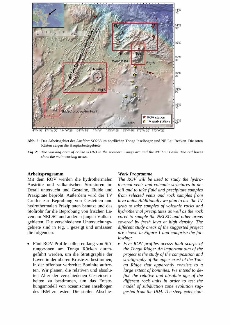
Abb. 2: Das Arbeitsgebiet der Ausfahrt SO263 im nördlichen Tonga Inselbogen und NE Lau Becken. Die roten Kästen zeigen die Hauptarbeitsgebiete.
Fig. 2: The working area of cruise SO263 in the northern Tonga arc and the NE Lau Basin. The red boxes show the main working areas.
Arbeitsprogramm Mit dem ROV werden die hydrothermalen Austritte und vulkanischen Strukturen im Detail untersucht und Gesteine, Fluide und Präzipitate beprobt. Außerdem wird der TV Greifer zur Beprobung von Gesteinen und hydrothermalen Präzipitaten benutzt und das Stoßrohr für die Beprobung von frischen La-ven am NELSC und anderen jungen Vulkan-gebieten. Die verschiedenen Untersuchungs-gebiete sind in Fig. 1 gezeigt und umfassen die folgenden:
• Fünf ROV Profile sollen entlang von Stö-rungszonen am Tonga Rücken durch-geführt werden, um die Stratigraphie derLaven in der oberen Kruste zu bestimmen,in der offenbar verbreitet Boninite auftre-ten. Wir planen, die relativen und absolu-ten Alter der verschiedenen Gesteinsein-heiten zu bestimmen, um das Entste-hungsmodell von ozeanischen Inselbögendes IBM zu testen. Die steilen Abschie-
Work Programme The ROV will be used to study the hydro-thermal vents and volcanic structures in de-tail and to take fluid and precipitate samples from selected vents and rock samples from lava units. Additionally we plan to use the TV grab to take samples of volcanic rocks and hydrothermal precipitates as well as the rock corer to sample the NELSC and other areas covered by fresh lava at high density. The different study areas of the suggested project are shown in Figure 1 and comprise the fol-lowing: • Five ROV profiles across fault scarps of
the Tonga Ridge: An important aim of theproject is the study of the composition andstratigraphy of the upper crust of the Ton-ga Ridge that apparently consists to alarge extent of boninites. We intend to de-fine the relative and absolute age of thedifferent rock units in order to test themodel of subduction zone evolution sug-gested from the IBM. The steep extension-
bungen im Tonga Rücken bieten bis zu 3 km hohe Aufschlüsse, die bisher nur ge-dredgt wurden und an denen die Lavast-ratigraphie bestimmt werden kann. Ein ähnlicher Ansatz funktionierte sehr gut während der SO229 in den Coriolis Troughs.
• Vier ROV Tauchgänge, CTD Stationenund TV Greifer-Einsätze sind an den jun-gen Vulkanen Niua N und S geplant, dieoffenbar die nördlichsten aktiven Vulkanedes Tonga Inselbogens darstellen. AnNiua N wurden bislang nur rhyolitischeLaven beprobt und dort gibt es Hoch-T-Vents, während Niua S ebenfalls rhyoliti-sche Proben lieferte und einen sehr akti-ven S-reichen Fluidaustritt aufweist. Wirplanen detaillierte Beprobung von vulka-nischen Gesteinen sowie hydrothermalenFluiden und Präzipitaten von diesenStrukturen, die neue Einblicke in die Un-terschiede zwischen verschiedenen hydro-thermalen und vulkanischen Prozessen anInselbögen geben werden. Speziell wer-den wir die Verbindungen zwischen derMagmenentgasung und den hydrotherma-len Fluiden untersuchen, um das Metall-budget der Fluide und der Präzipitate zubestimmen.
• Die Beprobung von verschiedenen subma-rinen Vulkanen südlich von Niua mit TVGreifer soll Aufschluss über die Zusam-mensetzung der Laven dort geben. DieseVulkane sollten nach existierenden Mo-dellen den Einfluss der subduziertenLouisville Seamountkette anzeigen.
• Der Niuatahi Vulkan im Back-arc miteiner ungewöhnlich großen Caldera mitca. 8 km Durchmesser sowie die damitverbundenen vulkanischen Rücken im Be-reich des NELSC sollen untersucht wer-den. Ein junger Vulkan in der Caldera(Motutahi) zeigte einen aktiven S Austrittin 2008 und 2012 und wir planen mehrereROV Tauchgänge, CTDs und TV Greifer-einsätze, um diese Struktur detailliert zubeproben und die rezente Aktivität zu un-tersuchen. Die Schwefelaustritte an die-sem Vulkan sind angereichert an volatilen
al faults provide up to 3 km high outcrops where crustal rocks are exposed and the lava stratigraphy can be studied. A simi-lar approach worked well, for example, during SO229 in the Coriolis Troughs.
• Four ROV dives, CTD stations and TVgrab sampling at the Niua N and S volca-noes that are supposed to be the north-ernmost active volcanoes of the Tofua arc:Niua N consists of rhyolitic lavas andhosts high temperature sulfide chimneyswhereas Niua S apparently consists ofrhyolite and shows a very active sulfur pit.Detailed sampling of volcanic rocks, hy-drothermal fluids and precipitates fromthese structures will yield new insights in-to the differences of hydrothermal andvolcanic processes in island arcs. Thiswill allow studying the link between mag-mas and hydrothermal fluids and the in-fluence of the magmatic volatiles on themetal budget of the hydrothermal fluidsand precipitates.
• Sampling of volcanic structures of thenorthern Tonga arc south of Niua withseveral TV grab stations. Little is knownabout the composition of lavas from thenorthern Tonga arc north of Tafahi andthus we suggest mapping and samplingthis region in order to better understandthe distribution of the Louisville slabcomponent.
• Sampling of the Niuatahi volcano and thevolcanic ridge connecting this volcano tothe NELSC. Niuatahi cone (Motutahi)showed an actively degassing sulfur pit in2008 and 2012 indicating it is active andwe plan several ROV dives, CTDs andseveral TV grabs on this cone in order tosample it in more detail and study any re-cent activity. The sulfur flows observed atthis volcano are enriched in volatile ele-ments suggesting significant input ofmagmatic volatiles. Sampling of thisstructure will allow determining the tem-
Elementen und zeigen den Austritt von magmatischen Volatilen. Die Beprobung dieser Struktur erlaubt Einblicke in die Entgasungsprozesse und den Fluss von Elementen vom Mantel in die Kruste und den Ozean. Außerdem planen wir Unter-suchungen der Calderaränder, an der älte-re Vulkanite aufgeschlossen sind, die Hinweise auf die frühe Entwicklung des Vulkans vor dem Einbruch der Caldera geben. Weitere Beprobung der Caldera und der jungen Lavaströme in der Umge-bung ist mit dem TV Greifer und Stoßrohr vorgesehen. Mehrere junge vulkanische Rücken liegen zwischen der Back-arc-Spreizungsachse des NELSC und dem Niuatahi Vulkan und auch diese Struktu-ren sollen beprobt werden, um den Mag-mentransport zwischen Back-arc Achse und Off-Axis Vulkan zu bestimmen.
• Am NELSC sind zwei hydrothermaleVent Sites bekannt, die 2008 aktiv warenund wir planen, eine dieser Gebiete mitdem ROV zu untersuchen, um die Ent-wicklung der Aktivität zu bestimmen. Wirerwarten, dass die Aktivität nachgelassenhat, nachdem das Venting in 2008 durcheinen kurz vorher erfolgten Vulkanaus-bruch ausgelöst wurde.
• Der NELSC propagiert im Süden in diealte Kruste des Tonga Rückens undbathymetrische Karten zeigen hier ver-schiedene vulkanische Strukturen, die mitdem ROV und TV- Greifer untersucht undbeprobt werden sollen. Damit sollen dieProzesse beim frühen Rifting eines Back-arcs bestimmt werden.
poral variations in degassing processes and flux of elements from the mantle to the crust and the ocean. Additionally, we plan one dive on one of the steep caldera walls in order to sample the volcano strati-graphically and determine its magmatic evolution. Additional sampling of the cal-dera and the young lava flows surround-ing the volcano will be done by TV grabs. The about 20 km long NE-SW striking ridge between Niuatahi and NELSC will be sampled by TV grab and rock corer in order to determine the compositional var-iation of the lavas.
• Detailed sampling of the southern NELSCby rock corer and study of the two siteswith hot hydrothermal venting in 2008 onthe NELSC using the ROV with two dives.We expect to find diminished hydrother-mal activity unless new volcanic activityoccurred on this segment.
• We plan one ROV dive at the volcanicstructure in the southernmost rift tip of theNELSC (Fig. 7) and several TV grabs onthe small seamounts in that area. Appar-ently, the NELSC is propagating into theolder crust of the Tonga Ridge and thuswe expect the magmas in this region to bedifferent from those of the NELSC furthernorth. The small volcanic seamounts fur-ther south probably represent a transitionbetween the NELSC and the FonualeiRidge.
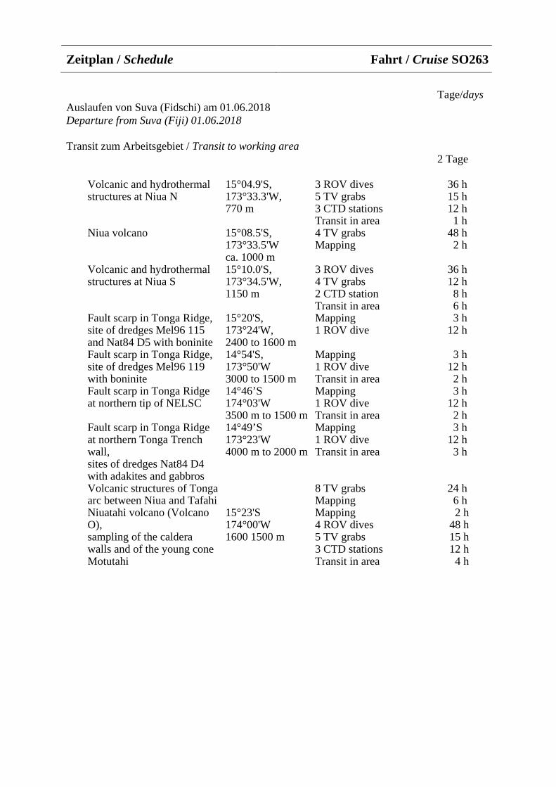
Zeitplan / Schedule Fahrt / Cruise SO263
Tage/days Auslaufen von Suva (Fidschi) am 01.06.2018 Departure from Suva (Fiji) 01.06.2018
Transit zum Arbeitsgebiet / Transit to working area 2 Tage
Volcanic and hydrothermal structures at Niua N
15°04.9'S, 173°33.3'W, 770 m
3 ROV dives 5 TV grabs 3 CTD stations Transit in area
36 h 15 h 12 h 1 h
Niua volcano 15°08.5'S, 173°33.5'W ca. 1000 m
4 TV grabs Mapping
48 h 2 h
Volcanic and hydrothermal structures at Niua S
15°10.0'S, 173°34.5'W, 1150 m
3 ROV dives 4 TV grabs 2 CTD station Transit in area
36 h 12 h 8 h 6 h
Fault scarp in Tonga Ridge, site of dredges Mel96 115 and Nat84 D5 with boninite
15°20'S, 173°24'W, 2400 to 1600 m
Mapping 1 ROV dive
3 h 12 h
Fault scarp in Tonga Ridge, site of dredges Mel96 119 with boninite
14°54'S, 173°50'W 3000 to 1500 m
Mapping 1 ROV dive Transit in area
3 h 12 h 2 h
Fault scarp in Tonga Ridge at northern tip of NELSC
14°46’S 174°03'W 3500 m to 1500 m
Mapping 1 ROV dive Transit in area
3 h 12 h 2 h
Fault scarp in Tonga Ridge at northern Tonga Trench wall, sites of dredges Nat84 D4 with adakites and gabbros
14°49’S 173°23'W 4000 m to 2000 m
Mapping 1 ROV dive Transit in area
3 h 12 h 3 h
Volcanic structures of Tonga arc between Niua and Tafahi
8 TV grabs Mapping
24 h 6 h
Niuatahi volcano (Volcano O), sampling of the caldera walls and of the young cone Motutahi
15°23'S 174°00'W 1600 1500 m
Mapping 4 ROV dives 5 TV grabs 3 CTD stations Transit in area
2 h 48 h 15 h 12 h 4 h
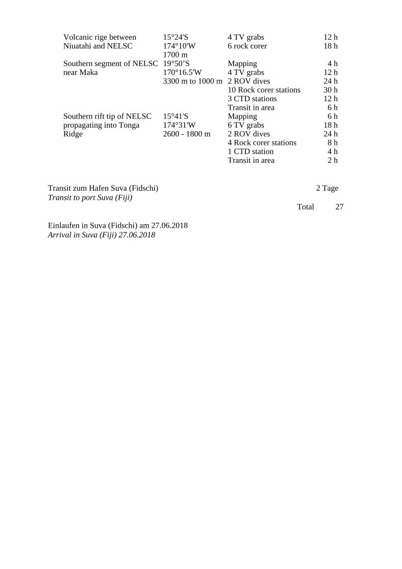
Volcanic rige between Niuatahi and NELSC
15°24'S 174°10'W 1700 m
4 TV grabs 6 rock corer
12 h 18 h
Southern segment of NELSC near Maka
19°50’S 170°16.5'W 3300 m to 1000 m
Mapping 4 TV grabs 2 ROV dives 10 Rock corer stations 3 CTD stations Transit in area
4 h 12 h 24 h 30 h 12 h 6 h
Southern rift tip of NELSC propagating into Tonga Ridge
15°41'S 174°31'W 2600 - 1800 m
Mapping 6 TV grabs 2 ROV dives 4 Rock corer stations 1 CTD station Transit in area
6 h 18 h 24 h 8 h 4 h 2 h
Transit zum Hafen Suva (Fidschi) 2 Tage Transit to port Suva (Fiji)
Total 27
Einlaufen in Suva (Fidschi) am 27.06.2018 Arrival in Suva (Fiji) 27.06.2018
Von/From Suva – Nach/To Yokohama Fahrt / Cruise SO264
Wissenschaftliches Programm SONNE-EMPEROR wird sich auf die Er-stellung eines neuen paläozeanographischen Nord-Süd-gerichteten Referenz-Transektes entlang der Emperor Seamount Chain im N-Pazifik konzentrieren. Unser Ansatz geht erstmalig über frühere Studien hinaus, die nur auf isolierte Standorte in dieser Region fokussierten. Wir werden Proxy-Zeitserien systematisch kompilieren, um die physikali-sche und chemische Paläozeanographie des N Pazifiks zwischen ~30°N und ~50°N zu rekonstruieren. Dieser Transekt quert wich-tige ozeanographische und klimatische Be-sonderheiten, darunter die Kuroshio Exten-sion, die Kuroshio Bifurkation, die Subarkti-sche Grenzlinie und die Subarktische Front (Abb. 03-1). Unser Ansatz wird es uns er-möglichen, sowohl zeitliche als auch räum-liche Veränderungen in den pelagischen subtropischen und subarktischen N-pazifischen Wirbeln im Bereich der ozeani-schen Deckschicht und in größeren Wasser-tiefen auf Zeitskalen von Jahrmillionen bis zu Jahrtausenden zu bestimmen. SONNE-EMPEROR wird damit ein dynamisches und dreidimensionales Verständnis der langfris-tigen Entwicklung von Klimazuständen und ihrer Kopplung sowohl zum regionalen Pa-zifik als auch zum Südpazifik und zum at-lantischen Großklima und Ozeanzirkulati-onsmuster ermöglichen. Ein wesentlicher Bestandteil wird die Ent-wicklung von Klimaproxy-Zeitreihen aus den weitgehend unerforschten küstenfernen Regionen des N Pazifiks sein - mit neuen, quantitativen paläozeanographischen und -klimatologischen Ansätzen. Da derartige Zeitreihen von landnahen Prozessen weitge-hend unbeeinflusst sind, werden sie für die Beurteilung von Ozean-Klima-Modellen zuverlässiger sein - obwohl von nur geringe-rer zeitlicher Auflösung. Damit werden wir zu einem besseren Verständnis der langfris-tigen Entwicklung von Klimazuständen im N Pazifik und ihren Kopplungen zu regiona-len und überregionalen Klimaveränderungen beitragen.
Scientific Programme SONNE-EMPEROR will focus on establish-ing a new paleoceanographic north - south reference transect along the Emperor Sea-mount Chain in the N Pacific. Our ap-proach for the first time progresses beyond previous studies of single isolated sites in this region, as we will systematically com-pile and study proxydata timeseries to re-construct the physical and chemical paleoceanography of the N Pacific between ~30°N and ~50°N. This transect will cross major oceanographic and climatic features, comprising the Kuroshio Extension, the Ku-roshio Bifurcation Front, the Subarctic Boundary, and the Subarctic Front (Fig. 03-1). Our approach will allow us to decipher both temporal and spatial variations in the pelagic N Pacific Subtropical and Subarctic Gyres at surface, subsurface, and deep level on millennial to orbital timescales. Hence, SONNE-EMPEROR will enable a dynamic and three-dimensional understanding of the long-term evolution of climate modes and their linkages not only to regional N Pacific, but also to S Pacific and Atlantic large-scale climate and ocean circulation patterns.
An integral part of SONNE-EMPEROR will be the development of climate proxy timeseries from the so far largely unex-plored offshore, pelagic N Pacific ocean areas with new, quantitative paleoceano-graphic and paleoclimatological methods. As such records will be rather unaffected by land-near processes – although being of lesser temporal resolution - they will be more reliable for ocean climate model as-sessment. Thus, we will contribute to a much improved understanding of the long-term evolution of climate modes and their linkage to regional N Pacific and large-scale varia-bility.
Wir werden spannende und vieldiskutierte Hypothesen zur Rolle des N Pazifiks im Hinblick auf folgende Themen ansprechen:
Entwicklung der subarktischen N-pazifischen Oberflächenschichtung: Aus-wirkungen auf das CO2-Gleichgewicht zwischen Ozean und Atmosphäre auf or-bitalen-tausendjährigen Zeitskalen Breiten- und Zeitveränderungen in der bio-genen Exportproduktion sowie die Grenzen und Effizienz der Nährstoffnutzung sollen abgeschätzt werden, die in hohen Breiten die Stärke der "biologischen Kohlenstoffpum-pe" maßgeblich bestimmen. Um die Mecha-nismen zu identifizieren, die Veränderungen der Wassermassenstruktur und der biologi-schen Produktivität sowie deren „Timing“ steuern, werden wir eine Multi-Proxy-Studie der deglazialen Umweltveränderungen bei höchstmöglicher zeitlicher Auflösung durch-führen. Insbesondere auf orbitalen Zeitska-len werden wir die Wechselwirkung zwi-schen dem N Pazifik, dem äquatorialen Pa-zifik und dem S Pazifik sowie die interhemi-sphärischen Beziehungen untersuchen. Wir werden unser Untersuchungsgebiet lateral erweitern, indem wir die Sedimentkerne der SO202 INOPEX Reise hinzuziehen (Ger-sonde et al., 2012, Rep. Polar Mar. Res. 643), aber auch die der SO225 MANIHIKI (tropischer W Pazifik) und SO213 SOPAT-RA-Projekte (S Pazifik) der Antragsteller. Wir werden dabei auf die vertikale Variabi-lität der Nährstoffverteilung und des Nähr-stoffverbrauchs und seine Beziehung zur Wassermassenstruktur der oberen Deck-schicht eingehen. Die Rolle der Beringstra-ßen-Öffnung vor ~11 ka BP soll hier be-trachtet werden.
Entwicklung der N pazifischen Subtropi-schen und Subarktischen Gyren Wir beabsichtigen, die subtropische bis sub-arktische N-pazifische Thermokline und Pycnocline auf plio/pleistozänen bis holozä-nen Zeitskalen und deren Reaktion auf glo-bale und regionale Veränderungen in Klima und Ozeanographie zu rekonstruieren. Die Wechselwirkungen zwischen dem subarkti-
We will address exciting and highly debated hypotheses on the role of the N Pacific con-cerning the following themes:
Development of Subarctic N Pacific Sur-face Stratification: Effects on Ocean - At-mosphere CO2 Balance over Orbital to Mil-lennial Timescales
We intend to assess latitudinal and temporal changes in biogenic export production, and the limits and efficiency of nutrient utiliza-tion, which determine to a large extent the strength of the “biological carbon pump” at high latitudes. To resolve the mechanisms driving changes in water mass structure and biological productivity and their timing, we will carry out a detailed multi-proxy study of deglacial environmental change at highest possible temporal resolution, but will also expand our studies to orbital timescales. In particular on orbital timescales, we will study the interaction between N Pacific, the equatorial Pacific, and S Pacific oceans, as well as the interhemispheric relationships. We will expand our study area laterally by considering the INOPEX SO202 sediment records (Gersonde et al., 2012, Rep. Polar Mar. Res. 643), but also the proxy records produced within the framework of the appli-cant’s BMBF-funded MANIHIKI (tropical W Pacific, SO225) and SOPATRA projects (S Pacific, SO213). We will further address the vertical variability in nutrient distribution and consumption and its relation to the up-per ocean water mass structure. We intend to assess whether the opening of the Bering Strait at ~11 ka BP affected N Pacific ocean stratification.
Development of the N Pacific Subtropical and Subarctic Gyres We intend to reconstruct the subtropical to subarctic N Pacific upper ocean thermocline and pycnocline on Plio/Pleistocene to Holo-cene timescales, and the response to global and regional changes in climate and ocean-ography. We will decipher the interaction between the subarctic and subtropical gyres,
schen und dem subtropischen Wirbel sowie die Veränderlichkeit und Funktionsweise des gegenwärtigen Kuroshio/Alaska Strom-systems und dessen Auswirkungen auf Meereis und Eisbergdynamik sollen betrach-tet werden. Da Ursachen und Konsequenzen vergangener wärmerer interglazialer Phasen in der N-pazifischen Meerestemperatur-Variabilität noch weitgehend ungeklärt sind (Max et al., 2012, Paleoceanogr. 27, doi:10.1029/2012PA002292; Max et al., 2014, Geology 41(10), doi:10.1130/G35879 .1), werden wir die räumliche Abdeckung der Emperor Seamount Chain mit hochqua-litativen Sedimentarchiven verbessern und uns auf Phasen der Erdgeschichte konzen-trieren, die wärmer waren als heute (frühes Holozän, MIS 5.5, MIS 11).
Die Rolle der pazifischen meridionalen Umwälzzirkulation im globalen Klimasys-tem Es ist nicht bekannt, ob die dichten Oberflä-chenwassermassen im N-Pazifik bis in die Zwischen- oder Tiefenwasserstocke vor-drangen und wie regional variabel solche Prozesse in der Vergangenheit waren. Eine Informationslücke besteht insbesondere bei 1000-3200 m Wassertiefe. Die Wassermas-sen unterhalb von 3000 m wurden zumindest nie belüftet (Keigwin, 1998, Paleoceanogr. 13). Diesem Problem soll mit neuen Sedi-mentarchiven aus Tiefen von <2000 bis ~5000 m und einem kombinierten Ansatz von benthischen δ13C- und Nd-Isotopen (εNd)-Rekonstruktionen begegnet werden, um die regionale/vertikale zeitliche Variabi-lität der tiefen und intermediären Ventilation auf geologischen Zeitskalen und die Bezie-hung zu entsprechenden Prozessen im Ochotskischen Meer und in der Beringsee (vgl. Bubenshchikova et al., 2015, Mar. Micropal. 121, doi:10.1016/j.marmicro. 2015.09.004.; Max et al., 2016, Paleocea-nogr. 32, doi: 10.1002/2016PA002994) zu entschlüsseln. Wir werden uns weiterhin mit den Ozean-Atmosphäre-Fernwirkungen zwi-schen N-Pazifik und Atlantik befassen.
Interozeanische Tele-Verbindungen im Pazifik - der Ozeantunnel
and the changeability and mode of function-ing of the Kuroshio and Alaska current sys-tem and its effect on sea ice and iceberg dynamics. As the causes and consequences of past warmer-than-present interglacial phases in N Pacific SST variability remained largely unexplained (Max et al., 2012; Paleoceanogr. 27, doi:10.1029/2012PA 002292; Max et al., 2014, Geology 41(10), doi:10.1130/G35879.1), we will enhance the still limited spatial coverage of high-quality sediment archives from the Emperor Sea-mount Chain and focus on intervals in Earth’s history that were warmer than today (early Holocene, MIS 5.5, MIS 11).
The Role of the Pacific Meridional Over-turning Circulation in the Global Climate System It is still unknown whether the dense surface water masses in the N Pacific penetrated to the intermediate or the deep-water level during the past and how regionally variable such processes were. So far, there is a gap in information between 1000 m and 3200 m water depth. The water masses below 3000 m experienced no ventilation (Keigwin, 1998, Paleoceanogr. 13). We plan to solve this problem with new sediment records from great depths (from <2000 to ~5000 m water depth) and by using a combined ap-proach of benthic δ13C and Nd isotope (εNd) reconstructions in order to decipher the re-gional/vertical temporal variability of deep and intermediate water ventilation on mil-lennial to orbital timescales, and the rela-tion to according processes in the Okhotsk and Bering seas (cf. Bubenshchikova et al., 2015, Mar. Micropal. 121, doi:10.1016/ j.marmicro. 2015.09.004.; Max et al., 2016,Paleoceanogr. 32, doi: 10.1002/2016PA 002994). We will further address questions regarding the ocean-atmosphere teleconnec-tions between the N Pacific and the Atlantic oceans.
Subsurface Inter-Oceanic Teleconnections in the Pacific – the Ocean Tunnel
Die Art und Weise, wie und ob der „subsur-face“ Wassermassenaustausch zwischen subtropischen und tropischen Ozeanregio-nen stattfindet, ist weiterhin umstritten. Die ozeanographischen Details eines solchen Wassermassenaustausches und deren Wege, als "Ozeantunnel" beschrieben, erfordern weitere Belege. Paläozeanographische Stu-dien konnten zeigen, dass Proxy-Parameter (z.B. εNd, Foraminiferen-Spurenelemente) empfindlich genug zu sein scheinen, um einen derartigen Wassermassenaustausch über geologische Zeiträume nachzuweisen. Weitere Modell- und Proxy-Studien sind jedoch erforderlich, um beurteilen zu kön-nen, ob die kleinskaligen Anomalien inner-halb der Thermokline (z.B. Temperatur, Salzgehalt, Nährstoffkonzentration, Belüf-tung, Isotopensignatur) über lange Distanzen aufrechterhalten bleiben und ob die Ausma-ße solcher Anomalien signifikant genug sind, um das gekoppelte Ozean-Atmos-phären-System nachhaltig zu beeinflussen. Wir sind zuversichtlich, dass wir die ausge-prägten langfristigen plio/pleistozänen Ver-änderungen der Temperatur und des Salz-gehaltes im „subsurface“-Bereich des äqua-torialen W Pazifiks (vgl. Raddatz et al., 2016, Paleo3 471, dx.doi.org/10.1016/ j.palaeo.2017.01.024; basierend auf Proxy-Ergebnissen aus dem SO225 MANIHIKI Projekt der Antragsteller) entweder im S- oder im N-Pazifik wiedererkennen können.
Düngung des pelagischen N-Pazifiks - atmosphärische vs. ozeanische Mikro-nährstoffquellen über die Zeit Der Transport von für die Bioproduktivität des pelagischen N Pazifiks benötigtem Eisen durch atmosphärischen Staub wird als wich-tigster Prozess angesehen, um der Mikro-nährstofflimitierung während der Eiszeiten entgegenzuwirken. Die Simulation von eis-zeitlicher Staubablagerung und deren Quell-regionen für die N-Pazifik-Region (Maho-wald et al., 1999, J. Geophys. Res. 104) än-derte die Ansichten über die Rolle des äo-lisch herangeführten Staubs für die Ozean-düngung in hohen Breiten. Eine systemati-sche Proxy-Studie über die zeitliche und räumliche Variabilität des äolischen Staub-
The manner in which the subsurface water mass exchange between subtropical and tropical ocean areas takes place is still a matter of debate. In particular, the oceano-graphic details of such flow and the path-ways of flow, likewise termed as „ocean tunnel“, need to be determined. Paleocean-ographic studies so far showed that the proxy parameters at hand (e.g., εNd, foram-iniferal trace elements) appear to be sensi-tive enough to trace such flow through geo-logic time. In this respect, further modeling and proxy studies are needed to assess whether the small-scale anomalies in ther-mocline water mass properties (e.g., tem-perature, salinity, nutrient concentration, ventilation, isotopic signature) can be main-tained over long distances, and whether the magnitudes of such anomalies are signifi-cant enough to affect the coupled ocean-atmosphere system. We are positive that we may relate the pronounced long-term Plio-/Pleistocene changes in subsurface tempera-ture, salinity, and thermocline depth in the equatorial W Pacific (cf. Raddatz et al., 2016, Paleo3 471, dx.doi.org/10.1016/ j.palaeo.2017.01.024 – based on proxy re-sults from the applicant´s BMBF-funded project SO225 MANIHIKI) – to either the S or the N Pacific area.
Fertilising the Pelagic N Pacific – Atmos-pheric vs. Oceanic Micronutrient Sources through Time Conventionally, transport of critically need-ed iron to the pelagic N Pacific by atmos-pheric dust is regarded as principal mecha-nism to relieve the upper ocean of micro-nutrient limitation during glacial times. The simulation of Last Glacial Maximum dust deposition and dust sources for the N Pacif-ic region (Mahowald et al., 1999, J. Ge-ophys. Res. 104) changed the views on the role of eolian dust for ocean fertilization during cool climates. A systematic proxy study on the temporal and spatial variability of eolian dust contribution to the N Pacific comprising areas within the Subtropical and
eintrages in den N-Pazifik, inklusive der subtropischen und subarktischen Wirbel, fehlt bislang. Unser N-S-orientiertes Kern-transekt wird es erlauben, Fragen bezüglich der äolischen Staubablagerung, seiner zeitli-chen und räumlichen Variabilität als Reakti-on auf Änderungen der atmosphärischen Zirkulation (Westwind Drift, siehe Abb. 03-1) und der Ausbreitung des Meereises unddessen Auswirkung auf die marine Produk-tivität anzugehen. Insbesondere scheint der Eintrag äolischen Staubes aus NE-Asien, die Verschiebung der Haupttransportbahnen auf glazialen/interglazialen Zeitskalen und die Bedeutung der äolischen Fe-Düngung für die Primärproduktivität und die Kohlen-stoffexporteffizienz wichtig. Unsere Arbei-ten werden zudem die zeitliche Veränder-lichkeit und Stärke des aleutischen Tief-drucksystems in Bezug auf die sibirische Hochdruckzelle und globale Zirkulations-muster beleuchten.
Subarctic gyres, however, is still missing. Our planned N-S-oriented core transect will allow to address issues concerning eolian dust deposition, its temporal and spatial variability in response to changes in atmos-pheric circulation (Westwind Drift, see Fig. 03-1) and sea ice distribution, and its effect on marine productivity. In particular, we will focus on eolian dust contribution from NE Asia, the shift of the main dust trajectory on glacial/interglacial timescales, and the importance of eolian Fe-fertilization for primary productivity and carbon export effi-ciency. These studies will also shed light on the temporal change and strength of the Aleutian Low Pressure System in relation to the Siberian High Pressure Cell and global circulation patterns.
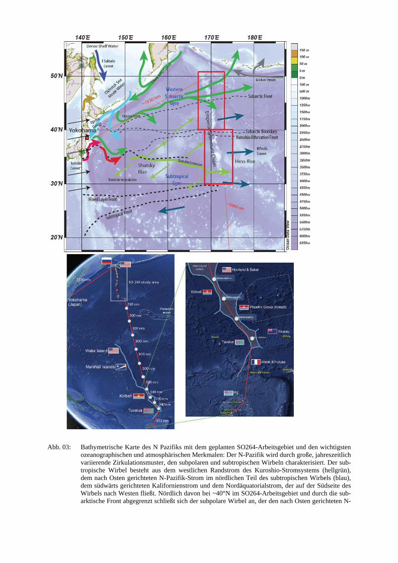
Abb. 03: Bathymetrische Karte des N Pazifiks mit dem geplanten SO264-Arbeitsgebiet und den wichtigsten ozeanographischen und atmosphärischen Merkmalen: Der N-Pazifik wird durch große, jahreszeitlich variierende Zirkulationsmuster, den subpolaren und subtropischen Wirbeln charakterisiert. Der sub-tropische Wirbel besteht aus dem westlichen Randstrom des Kuroshio-Stromsystems (hellgrün), dem nach Osten gerichteten N-Pazifik-Strom im nördlichen Teil des subtropischen Wirbels (blau), dem südwärts gerichteten Kalifornienstrom und dem Nordäquatorialstrom, der auf der Südseite des Wirbels nach Westen fließt. Nördlich davon bei ~40°N im SO264-Arbeitsgebiet und durch die sub-arktische Front abgegrenzt schließt sich der subpolare Wirbel an, der den nach Osten gerichteten N-
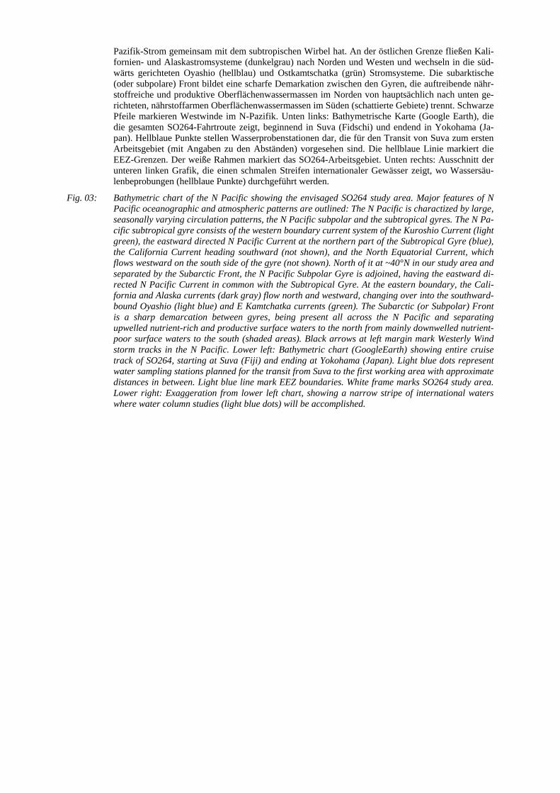
Pazifik-Strom gemeinsam mit dem subtropischen Wirbel hat. An der östlichen Grenze fließen Kali-fornien- und Alaskastromsysteme (dunkelgrau) nach Norden und Westen und wechseln in die süd-wärts gerichteten Oyashio (hellblau) und Ostkamtschatka (grün) Stromsysteme. Die subarktische (oder subpolare) Front bildet eine scharfe Demarkation zwischen den Gyren, die auftreibende nähr-stoffreiche und produktive Oberflächenwassermassen im Norden von hauptsächlich nach unten ge-richteten, nährstoffarmen Oberflächenwassermassen im Süden (schattierte Gebiete) trennt. Schwarze Pfeile markieren Westwinde im N-Pazifik. Unten links: Bathymetrische Karte (Google Earth), die die gesamten SO264-Fahrtroute zeigt, beginnend in Suva (Fidschi) und endend in Yokohama (Ja-pan). Hellblaue Punkte stellen Wasserprobenstationen dar, die für den Transit von Suva zum ersten Arbeitsgebiet (mit Angaben zu den Abständen) vorgesehen sind. Die hellblaue Linie markiert die EEZ-Grenzen. Der weiße Rahmen markiert das SO264-Arbeitsgebiet. Unten rechts: Ausschnitt der unteren linken Grafik, die einen schmalen Streifen internationaler Gewässer zeigt, wo Wassersäu-lenbeprobungen (hellblaue Punkte) durchgeführt werden.
Fig. 03: Bathymetric chart of the N Pacific showing the envisaged SO264 study area. Major features of N Pacific oceanographic and atmospheric patterns are outlined: The N Pacific is charactized by large, seasonally varying circulation patterns, the N Pacific subpolar and the subtropical gyres. The N Pa-cific subtropical gyre consists of the western boundary current system of the Kuroshio Current (light green), the eastward directed N Pacific Current at the northern part of the Subtropical Gyre (blue), the California Current heading southward (not shown), and the North Equatorial Current, which flows westward on the south side of the gyre (not shown). North of it at ~40°N in our study area and separated by the Subarctic Front, the N Pacific Subpolar Gyre is adjoined, having the eastward di-rected N Pacific Current in common with the Subtropical Gyre. At the eastern boundary, the Cali-fornia and Alaska currents (dark gray) flow north and westward, changing over into the southward-bound Oyashio (light blue) and E Kamtchatka currents (green). The Subarctic (or Subpolar) Front is a sharp demarcation between gyres, being present all across the N Pacific and separating upwelled nutrient-rich and productive surface waters to the north from mainly downwelled nutrient-poor surface waters to the south (shaded areas). Black arrows at left margin mark Westerly Wind storm tracks in the N Pacific. Lower left: Bathymetric chart (GoogleEarth) showing entire cruise track of SO264, starting at Suva (Fiji) and ending at Yokohama (Japan). Light blue dots represent water sampling stations planned for the transit from Suva to the first working area with approximate distances in between. Light blue line mark EEZ boundaries. White frame marks SO264 study area. Lower right: Exaggeration from lower left chart, showing a narrow stripe of international waters where water column studies (light blue dots) will be accomplished.
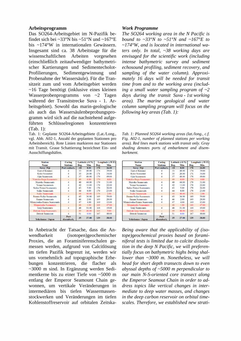
Arbeitsprogramm Das SO264-Arbeitsgebiet im N-Pazifik be-findet sich bei ~33°N bis ~51°N und ~167°E bis ~174°W in internationalen Gewässern. Insgesamt sind ca. 38 Arbeitstage für die wissenschaftlichen Arbeiten vorgesehen (einschließlich zeitaufwendiger bathymetri-scher Kartierungen und Sedimentecholot-Profilierungen, Sedimentgewinnung und Probenahme der Wassersäule). Für die Tran-sitzeit zum und vom Arbeitsgebiet werden ~16 Tage benötigt (inklusive eines kleinen Wasserprobenprogramms von ~2 Tagen während der Transitstrecke Suva - 1. Ar-beitsgebiet). Sowohl das marin-geologische als auch das Wassersäulenbeprobungspro-gramm wird sich auf die nachstehend aufge-führten Schlüsselregionen konzentrieren (Tab. 1): Tab. 1: Geplante SO264-Arbeitsgebiete (Lat./Long., vgl. Abb. A02-1, Anzahl der geplanten Stationen pro Arbeitsbereich). Rote Linien markieren nur Stationen mit Transit. Graue Schattierung bezeichnet Ein- und Ausschiffungshäfen.
In Anbetracht der Tatsache, dass die An-wendbarkeit (isotopen)geochemischer Proxies, die an Foraminiferenschalen ge-messen werden, aufgrund von Calcitlösung im tiefen Pazifik begrenzt ist, werden wir uns vornehmlich auf topographische Erhe-bungen konzentrieren, die flacher als ~3000 m sind. In Ergänzung werden Sedi-mentkerne bis zu einer Tiefe von ~5000 m entlang der Emperor Seamount Chain ge-wonnen, um vertikale Veränderungen in intermediären bis tiefen Wassermassen-stockwerken und Veränderungen im tiefen Kohlenstoffreservoir auf orbitalen Zeitska-
Work Programme The SO264 working area in the N Pacific is bound to ~33°N to ~51°N and ~167°E to ~174°W, and is located in international wa-ters only. In total, ~38 working days are envisaged for the scientific work (including intense bathymetric survey and sediment echosound profiling, sediment recovery, and sampling of the water column). Approxi-mately 16 days will be needed for transit time from and to the working area (includ-ing a small water sampling program of ~2 days during the transit Suva - 1st working area). The marine geological and water column sampling program will focus on the following key areas (Tab. 1):
Tab. 1: Planned SO264 working areas (lat./long., c.f. Fig. A02-1, number of planned stations per working area). Red lines mark stations with transit only. Gray shading denotes ports of embarkment and disem-barkment.
Being aware that the applicability of (iso-tope)geochemical proxies based on forami-niferal tests is limited due to calcite dissolu-tion in the deep N Pacific, we will preferen-tially focus on bathymetric highs being shal-lower than ~3000 m. Nonetheless, we will head for short depth transects down to even abyssal depths of ~5000 m perpendicular to our main N-S-oriented core transect along the Emperor Seamout Chain in order to ad-dress topics like vertical changes in inter-mediate to deep water masses, and changes in the deep carbon reservoir on orbital time-scales. Therefore, we established new strati-
len zu rekonstruieren. Dazu werden neue stratigraphische und paläozeanographische Werkzeuge angewandt, um Calcit-freie Se-dimente in unsere Untersuchungen einzube-ziehen. Vorhergehende Arbeiten haben gezeigt, dass Sedimentkerne von der Emperor Seamount Chain in Bezug auf paläozeanographische Untersuchungen eine z.T. hohe Qualität aufweisen. Während Sedimentationsraten oft niedrig sind, existieren dennoch ausreichend hohe Akkumulationsbereiche, um eine tau-sendjährige Auflösung zu erreichen (z. B. Gebhardt et al., 2008, Paleoceanogr. 23, doi:10.1029/2007PA001513; Jaccard und Galbraith, 2013, Geophys. Res. Lett. 40). Mit dem Einsatz modernster hydroakusti-scher Methoden und einer detaillierten Kar-tierung (KONGSBERG EM122, ATLAS-Parasound) werden wir in der Lage sein, Sedimentbecken und -taschen mit relativ hohen Sedimentationsraten und ungestörten, calcit-reichen Sedimenten zu finden. In grö-ßeren Tiefen werden die Sedimentationsra-ten niedriger sein, was uns aber erlauben wird, weiter zurück in die Vergangenheit zu gehen, mit besonderem Fokus auf die letzten Millionen Jahre (wie sie in paläoklimati-schen Referenzdatensätzen sowohl aus ant-arktischen Eisbohrkernen als auch aus N-pazifischen Randbecken aufgezeichnet sind). Seismische Informationen aus frühe-ren Aktivitäten (DSDP, ODP, WEPAMA, INOPEX) liefern wertvolle Informationen für das geplante hydroakustische Surveying und die Auswahl von Kernstandorten. Die oben genannten Forschungsziele werden durch die Anwendung konventioneller und innovativer, hauptsächlich (isotopen) geo-chemischer Proxies verfolgt, die die physi-kalischen Eigenschaften der Wassermassen (Temperatur und Salzgehalt, Thermoklinen-änderung, Ozeanschichtung), die chemische Zusammensetzung des Meerwassers, Ter-rigeneintrag und äolische Staubzufuhr, ma-rine Produktivität und damit verbundene Nährstoffnutzung, Mode-, und Tiefenwas-serventilation, -formation und –zirku-lationsänderungen. Diese Proxys wurden teilweise von den Antragstellern in anderen Forschungsprojekten erfolgreich angewen-
graphical and paleoceanographical tools to include calcite-free sediments into our stud-ies.
Previous studies have shown that sediment cores from the Emperor Seamount Chain have high quality with respect to paleocean-ographic studies. While sedimentation rates are often low, sufficient higher-accumulation areas exist to even resolve millennial-scale patterns (e.g., Gebhardt et al., 2008, Paleoceanogr. 23, doi:10.1029 /2007PA001513; Jaccard und Galbraith, 2013, Geophys. Res. Lett. 40). By using state-of-the-art hydroacoustic techniques and carrying out detailed mapping (KONGSBERG EM122, ATLAS-Parasound), we are positive to find sediment basins (pockets) at bathymetric highs showing rela-tively high sedimentation rates of calcite-bearing, undisturbed sediments. At greater depths, sedimentation rates will be lower, allowing us to go further back in time, with a particular focus on the last million years (well recorded in paleoclimatic reference records from Antarctic ice cores and N Pa-cific marginal basins). Seismic information from previous activities (DSDP, ODP, WEPAMA, INOPEX) will provide valuable information for planned hydroacoustic sur-veying and selection of core locations.
The abovementioned research objectives will be pursued by merging conventional and innovative, mainly (isotope)geochemical proxies reflecting physical properties of water masses, (sea surface, subsurface, and intermediate water temperature and salinity, thermocline change, ocean stratification), chemical composition of seawater, terri-genous flux and eolian dust supply, marine productivity, and related nutrient utilization, mode, intermediate, and deep water ventila-tion, formation, and circulation changes. These proxies have been partly established and widely used by the applicants within other research projects. Our experience with

det. Unsere Erfahrung mit einem derartigen Multi-Proxy-Ansatz wird es uns ermögli-chen, die geplanten Studien erfolgreich durchzuführen. Proxies werden sowohl im Gesamtsediment als auch in biogenen Sig-nalträgern (z.B. Foraminiferen, Diatomeen, organischem Gewebe) gemessen.
such a multi-proxy approach will allow us to successfully carry out the envisioned studies. Proxies will be measured in both bulk sedi-ments from cores retrieved, and in biogenic signal carriers (e.g. foraminifers, diatoms, organic tissue).
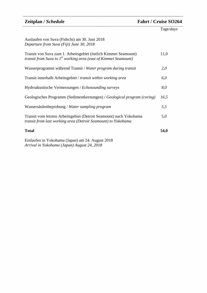
Tage/days
Auslaufen von Suva (Fidschi) am 30. Juni 2018 Departure from Suva (Fiji) June 30, 2018
Transit von Suva zum 1. Arbeitsgebiet (östlich Kimmei Seamount) 11,0 transit from Suva to 1st working area (east of Kimmei Seamount)
Wasserprogramm während Transit / Water program during transit 2,0
Transit innerhalb Arbeitsgebiet / transit within working area 6,0
Hydroakustische Vermessungen / Echosounding surveys 8,0
Geologisches Programm (Sedimentkernungen) / Geological program (coring) 16,5
Wassersäulenbeprobung / Water sampling program 5,5
Transit vom letzten Arbeitsgebiet (Detroit Seamount) nach Yokohama 5,0 transit from last working area (Detroit Seamount) to Yokohama
Total 54,0
Einlaufen in Yokohama (Japan) am 24. August 2018 Arrival in Yokohama (Japan) August 24, 2018
Zeitplan / Schedule Fahrt / Cruise SO264
Von/From Yokohama – Nach/To Kaohsiung Fahrt / Cruise SO265
Wissenschaftliches Programm Die Entstehung der großen submarinen vul-kanischen Plateaus in den Ozeanbecken ist immer noch weitgehend umstritten. Die FS SONNE-Reise SO265 hat zum Ziel, die vul-kanische Entwicklung von Shatsky Rise zu untersuchen und zu erkunden, ob dieses Pla-teau in ein (oder zwei) altersprogressive Hotspotspuren übergeht (Papanin Ridge und/oder Ojin Seamount Provinz), die sich scheinbar bis zum benachbarten Hess Rise verfolgen lassen (Abb. 4). Die Erkenntnisse der kürzlich durchgeführten IODP (In-tegrated Ocean Drilling Program) Expediti-on 324 sind vereinbar mit der Hypothese, dass Shatsky Rise durch Interaktion eines Mantelplumes mit einer Spreizungszone (triple junction) entstanden ist. Allerdings konnte die Beteiligung eines (tiefen) Man-telplumes nicht zwingend nachgewiesen werden. Eindeutige Erkenntnisse darüber können nur vom jungen Ende des Shatsky Rise kommen, wo das Plateau in eine schmale, mögliche Hotspotspur übergeht. Das stärkste Argument für eine Hotspotspur, und für die Beteiligung eines Mantelplumes, wäre der Nachweis einer Altersprogression des Vulkanismus entlang des 500 km langen Papanin Ridge und/oder der Ojin Seamount Provinz.
Insbesondere sollen die folgenden wissen-schaftlichen Fragen und Hypothesen unter-sucht werden:
Arbeitsgebiet I: Nördlicher Teil des Shatsky Rise • Was ist die zeitliche und geochemische
Spannbreite des Vulkanismus am nördli-chen (jungen) Ende des Shatsky Rise?Kann dort ein geringerer Aufschmelzgradund eine stärkere geochemische Hetero-genität (im Vergleich zum Hauptplateau)nachgewiesen werden, wie es basierendauf den Ergebnissen von IODP Exp. 324vermutet wird?
• Wenn ja, ist dies ein Zeichen für den
Scientific Programme The origin of large igneous provinces is a subject of an ongoing debate. R/V SONNE cruise SO265 focuses on the post-plateau volcanic evolution of Shatsky Rise to test if the plateau transitions into one (or two) age-progressive hotspot tracks (Papanin Ridge and/or Ojin Seamount Province) pos-sibly continuing to Hess Rise (Fig. 4). Shat-sky Rise was recently drilled during IODP (Integrated Ocean Drilling Program) expe-dition 324. The drilling results are con-sistent with the hypothesis that Shatsky Rise formed by a mantle plume interacting with a triple junction, although the evidence for the involvement of a (deep) mantle plume is not unequivocal. Linking Shatsky Rise to an age-progressive hotspot track would provide the most-convincing evidence thus far that Shatsky Rise was formed by a mantle plume. SO265 shall sample the northern edge of Shatsky Rise, the more than 500 km long Papanin Ridge and the Ojin Seamount prov-ince, which both could represent the begin-ning of a Shatsky hotspot track.
In particular the following scientific ques-tions and hypotheses shall be addressed:
Working area I: Northern part of Shatsky Rise • What is the range of age and geochemi-
cal composition across the northernedge of the Shatsky Rise? Can increasedgeochemical heterogeneity and a de-creased degree of melting (in compari-son to the main plateau) be detected assuggested by the expedition 324 drillingresults?
• If so, does this point towards the transi-
Übergang von geochemisch homogenen Plateau-Vulkanismus zu einem geoche-misch angereicherten und mehr heteroge-nen Hotspotspur-Vulkanismus?
Arbeitsgebiet II: Papanin Rücken • Was ist das Alter und die geochemische
Zusammensetzung von Papanin Ridge?Repräsentiert er den Anfang einer alters-progressiven Shatsky-Hotspot-Spur?Wenn ja, erwarten wir, 1) dass der Rü-cken jünger als die Hauptphase des Shir-shov Massiv-Vulkanimus ist und 2) dassdie Altersprogression entlang des Rü-ckens von NO (jünger) nach SW verläuft.Es soll auch überprüft werden ob der Pa-panin Ridge im Vergleich zum ShatskyPlateau eine größere geochemische Hete-rogenität aufweist, da Quellenheterogeni-täten bei niedrigeren Aufschmelzgradenim Plume-Stiel besser erhalten bleiben alsbeim exzessiven Aufschmelzen währendPlume-Kopf-Rücken Interaktion.
• Lassen sich Hinweise auf eine räumlichegeochemische Zonierung entlang des Pa-panin Ridge finden? Da die geographi-sche Lage des Shatsky Rise am Beginnder Kreidezeit auf den Rand der Pazifi-schen LLSVP (Large Low Shear VelocityProvince) rekonstruiert wurde (scheinbareine Voraussetzung für die Entstehungvon zonierten Hotspots), ist es gut mög-lich, dass auch Papanin Ridge eine solcheZonierung zeigt. Daher muss überprüftwerden, ob Proben von der Westseite desRückens eine andere geochemische Zu-sammensetzung aufweisen als Probenvon der Ostflanke.
Arbeitsgebiet III: Ojin Seamount Provinz • Was ist das Alter und geochemische Zu-
sammensetzung der Ojin Seamount Pro-vinz und in welcher Beziehung steht die-se Provinz zum Shatsky Rise? Gibt es ei-ne Altersprogression, die sich vom Wes-ten gen Osten hin verjüngt und die kurznach der Bildung des Shirshov-Massivseinsetzt? Dies könnte den Beweis dafürliefern, dass die Seamount Provinz einevom Shatsky Rise ausgehende Hotspot-
tion from a more geochemically homo-geneous plateau volcanism to a general-ly more geochemically enriched and het-erogeneous hotspot track volcanism?
Working area II: Papanin Ridge • What is the age and geochemical com-
position of Papanin Ridge? Does thisridge represent the beginning of a Shat-sky hotspot track? If so, we would 1) ex-pect ages younger then the main phaseof volcanism on the Shirshov Massif and2) an age progression along the ridgewith lavas in the NE being younger than in the SW. Also, we want to test if great-er geochemical heterogeneity is present in the Papanin Ridge compared with the Shatsky Rise, because source heteroge-neity is better preserved at lower-degrees of melting in the plume conduit compared to plume head - ridge interac-tion.
• Is there evidence for a spatial geochemi-cal zonation across Papanin Ridge?Since Shatsky was located at the edge ofthe lower mantle Pacific superswell(LLSVP) in the Early Cretaceous (ap-parently a precondition for generatingzoned hotspots), it is possible that Pa-panin Ridge is geochemically zoned aswell. Therefore, it shall be tested if sam-ples from the western flank of the ridgehave different isotope signatures thansamples from the eastern flank.
Working area III: Ojin Seamount Province • What is the age and geochemical com-
position of the Ojin Seamount Provinceand what is their relation to ShatskyRise? Do they show a west to eastyounging age progression beginningshortly after formation of the ShirshovMassif, which would provide evidencethat they could represent a hotspot trackassociated with the Shatsky Rise. If bothPapanin Rise and Ojin Seamounts prove
Spur darstellt. Wenn sich sowohl der Pa-panin Rücken als auch die Ojin Se-amounts als vom Shatsky Rise ausgehen-de Hotspot-Spuren erweisen, stellt sich die Frage, ob jede Spur eine eigene Zu-sammensetzung hat, die eine räumliche Zonierung reflektiert wie sie kürzlich für das Tristan-Gough-Hotspotspur-System im Südatlantik nachgewiesen wurde.
• Falls sich keine Altersprogression gemäßeiner Hotspot-Spur nachweisen lässt,stellt sich die Frage nach einem alternati-ven Modell für die Entstehung dieserweiträumigen Seamount-Provinz. Reprä-sentieren die Seamounts reaktiviertenVulkanismus, der irgendwie im Bezugzum Shatsky-Plateau-Vulkanismus steht(wie auch für andere pazifische Plateausdiskutiert wird: z. B. Ontong Java, Hiku-rangi, Manihiki)? Wenn ja, was hat dieseReaktivierung verursacht? Letztlich sollgeklärt werden ob die Ojin SeamountProvinz zeitgleich mit den ozeanischenanoxischen Ereignis (OAE) 1 oder 2 ent-standen ist, was auf einen kausalen Zu-sammenhang hindeuten könnte.
Wir erwarten, dass SO265 einen wesentli-chen Beitrag zur Beantwortung der noch offenen Fragen hinsichtlich der Entstehung von ozeanischen Plateaus (Shatsky), Unter-wasserrücken (Papanin) und Seamountpro-vinzen (Ojin) leisten wird (Bezug zum FONA-Unterprogramm GEO:N). Weiterhin können die gewonnen bathymetrischen Da-ten und petrologischen Erkenntnisse auch für zukünftige umweltschutzrechtliche (z.B. Ausweisung von zukünftigen Fischerei-Schutzgebieten) und wirtschaftliche (Roh-stoffpotenzial von vulkanischen Plateaus) Fragestellungen relevant sein.
to be hotspot tracks related to Shatsky, then an important question is if each track shows a distinct composition, re-flecting a spatially zoned plume, similar to what has been observed for the Tris-tan-Gough hotspot track system in the South Atlantic.
• Alternatively, if the Ojin seamounts donot show the proper age-progression tobe a hotspot track, what is the origin ofthis vast seamount province? Do theyrepresent reactivated volcanism associ-ated somehow with the plateau (also dis-cussed for other plateaus in the Pacific,e.g. Ontong Java, Hikurangi, Manihiki)and if so, what are the mechanisms forcausing such reactivation? Finally, isthe age of the Ojin seamount formationcontemporaneous to the oceanic anoxicevent (OAE) 1 or 2 implying a causalconnection?
In conclusion, we believe that SO265 will make significant contributions to solving outstanding questions concerning the origin of oceanic plateaus (Shatsky), submarine ridges (Papanin) and seamount provinces (Ojin) (reference to FONA-subprogram GEO:N). Furthermore, the obtained bath-ymetric and petrological data could become relevant for future ecological (e.g. estab-lishment of marine protected areas) or eco-nomic (resource potential of volcanic plat-eaus) questions.
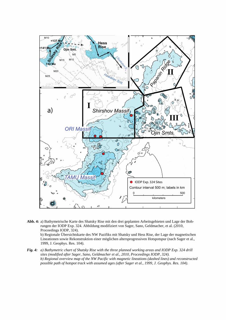
Abb. 4: a) Bathymetrische Karte des Shatsky Rise mit den drei geplanten Arbeitsgebieten und Lage der Boh-rungen der IODP Exp. 324. Abbildung modifiziert von Sager, Sano, Geldmacher, et al. (2010, Proceedings IODP, 324). b) Regionale Übersichtskarte des NW Pazifiks mit Shatsky und Hess Rise, der Lage der magnetischenLineationen sowie Rekonstruktion einer möglichen altersprogressiven Hotspotspur (nach Sager et al., 1999, J. Geophys. Res. 104).
Fig. 4: a) Bathymetric chart of Shatsky Rise with the three planned working areas and IODP Exp. 324 drill sites (modified after Sager, Sano, Geldmacher et al., 2010, Proceedings IODP, 324). b) Regional overview map of the NW Pacific with magnetic lineations (dashed lines) and reconstructedpossible path of hotspot track with assumed ages (after Sager et al., 1999, J. Geophys. Res. 104).
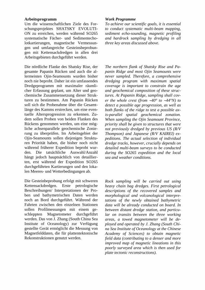
Arbeitsprogramm Um die wissenschaftlichen Ziele des For-schungsprojektes SHATSKY EVOLUTI-ON zu erreichen, werden während SO265 systematische Fächer- und Sedimentecho-lotkartierungen, magnetische Vermessun-gen und umfangreiche Gesteinsbeprobun-gen mit Kettensackdredgen in allen drei Arbeitsgebieten durchgeführt werden.
Die nördliche Flanke des Shatsky Rise, der gesamte Papanin Rücken und auch die al-lermeisten Ojin-Seamounts wurden bisher noch nie beprobt. Daher ist ein umfassendes Dredgeprogramm mit maximaler räumli-cher Erfassung geplant, um Alter und geo-chemische Zusammensetzung dieser Struk-turen zu bestimmen. Am Papanin Rücken soll sich die Probenahme über die Gesamt-länge des Kamms erstrecken, um eine even-tuelle Altersprogression zu erkennen. Zu-dem sollen Proben von beiden Flanken des Rückens genommen werden, um eine mög-liche achsenparallele geochemische Zonie-rung zu überprüfen. Im Arbeitsgebiet der Ojin-Seamounts sollen diejenigen Struktu-ren Priorität haben, die bisher noch nicht während früherer Expedition beprobt wur-den. Die tatsächliche Auswahl/Anzahl hängt jedoch hauptsächlich von detaillier-ten, erst während der Expedition SO265 durchgeführten Kartierungen und den loka-len Meeres- und Wetterbedingungen ab.
Die Gesteinbeprobung erfolgt mit schweren Kettensackdredgen. Erste petrologische Beschreibungen/ Interpretationen der Pro-ben und bathymetrischen Daten werden noch an Bord durchgeführt. Während der Fahrten zwischen den einzelnen Stationen sollen Profilmessungen mit einem ge-schleppten Magnetometer durchgeführt werden. Das von J. Zhang (South China Sea Institute of Oceanology) zur Verfügung gestellte Gerät ermöglicht die Messung von Magnetfelddaten, die für plattentektonische Rekonstruktionen genutzt werden.
Work Programme To achieve our scientific goals, it is essential to conduct systematic multi-beam mapping, sediment echo-sounding, magnetic profiling and hardrock sampling by dredging in all three key areas discussed above.
The northern flank of Shatsky Rise and Pa-panin Ridge and most Ojin Seamounts were never sampled. Therefore, a comprehensive dredging program with maximum spatial coverage is important to constrain the age and geochemical composition of these struc-tures. At Papanin Ridge, sampling shall cov-er the whole crest (from ∼40° to ∼44°N) to detect a possible age progression, as well as both flanks of the ridge to test a possible ax-is-parallel spatial geochemical zonation. When sampling the Ojin Seamount Province, priority shall be given to structures that were not previously dredged by previous US (R/V Thompson) and Japanese (R/V KAIREI) ex-peditions. The actual selection of individual dredge tracks, however, crucially depends on detailed multi-beam surveys to be conducted during the SO265 expedition and the local sea and weather conditions.
Rock sampling will be carried out using heavy chain bag dredges. First petrological descriptions of the recovered samples and morphological and volcanological interpre-tations of the newly obtained bathymetric data will be already conducted on board. In between distant dredge station, and particu-lar on transits between the three working areas, a towed magnetometer will be de-ployed and operated by J. Zhang (South Chi-na Sea Institute of Oceanology at the Chinese Academy of Sciences) to obtain magnetic field data (contributing to a denser and more improved map of magnetic lineations in this poorly surveyed area which is then used for plate tectonic reconstructions).
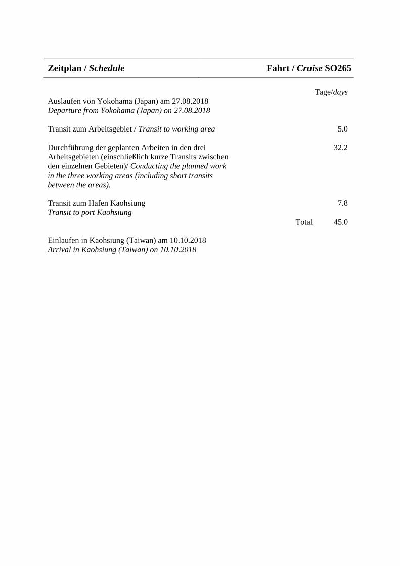
Zeitplan / Schedule Fahrt / Cruise SO265
Tage/days Auslaufen von Yokohama (Japan) am 27.08.2018 Departure from Yokohama (Japan) on 27.08.2018
Transit zum Arbeitsgebiet / Transit to working area 5.0
Durchführung der geplanten Arbeiten in den drei 32.2 Arbeitsgebieten (einschließlich kurze Transits zwischen den einzelnen Gebieten)/ Conducting the planned work in the three working areas (including short transits between the areas).
Transit zum Hafen Kaohsiung 7.8 Transit to port Kaohsiung
Total 45.0
Einlaufen in Kaohsiung (Taiwan) am 10.10.2018 Arrival in Kaohsiung (Taiwan) on 10.10.2018
Beteiligte Institutionen / Participating Institutions
AWI Alfred-Wegener-Institut Helmholtz-Zentrum für Polar- und Meeresforschung Am Alten Hafen 26 D-27570 Bremerhaven / Germany www.awi.de
CADIC-CONICET Laboratorio de Oceanografía Bernardo Houssay 200 9410 Ushuaia, Tierra del Fuego / Argentine www.cadic-conicet.gob.ar/
CHIBA UNIVERSITY Department of Earth Sciences 1-33 Yayoi-cho, Inage-ku, Chiba-shi 263-8522, Japan www.chiba-u.ac.jp/e/index.html
DWD Deutscher Wetterdienst Seeschifffahrtsberatung Bernhard-Nocht-Straße 76 20359 Hamburg / Germany www.dwd.de
FIO The First Institute of Oceanography State Oceanic Administration No. 6 Xianxialing Road, Qingdao, China www.fio.org.cn
GEOMAR Helmholtz-Zentrum für Ozeanforschung Kiel Wischhofstraße 1-3 D-24148 Kiel / Germany www.geomar.de/
GEOTOP & Département des Sciences de la Terre et de l’Atmosphère Université du Québec à Montréal CP 8888, Succ. Centre-Ville Montréal, Québec, H3C 3P8, Canada www.geotop.ca/
GZN GeoZentrum Nordbayern Friedrich-Alexander-Universität Erlangen-Nürnberg, Schlossgarten 5 91054 Erlangen Germany www.gzn.nat.fau.de
IFG/UNIV. KIEL Institut für Geowissenschaften Christian-Albrechts-Universität zu Kiel Ludewig-Meyn-Straße 10 D-24118 Kiel / Germany www.ifg.uni-kiel.de
JAMSTEC Japan Agency for Marine-Earth Science and Technology 2-15, Natsushima-cho, Yokosuka-city, Kanagawa, 237-0061, Japan www.jamstec.go.jp/e/
JUB Physics & Earth Sciences Jacobs University Bremen Campus Ring 1 28759 Bremen Germany www.jacobs-university.de/
LDEO Lamont-Doherty Earth Observatory Columbia University 61 Route 9W Palisades, NY 10964, USA www.ldeo.columbia.edu/
MARUM Universität Bremen Fachbereich Geowissenschaften Postfach 33 04 40 28334 Bremen / Germany www.marum.de
MARUM Zentrum für Marine Umweltwissenschaften der Universität Bremen Leobener Str. 8 D-28359 Bremen Germany www.marum.de

MFM Museum für Naturkunde Berlin Leibniz-Institut für Evolutions- und Biodiversitätsforschung Invalidenstr. 43 10115 Berlin / Deutschland www.museumfuernaturkunde.berlin/
MPI Max-Planck-Institut für Marine Mikrobiologie, Celsiusstrasse 1 28359 Bremen Germany www.mpi-bremen.de
MPI Max Planck Institute for Chemistry Climate Geochemistry Hahn-Meitner-Weg 1 D-55128 Mainz / Germany www.mpic.de
MUSEUM TOKYO National Museum of Nature and Science Department of Geology and Paleontology 4-1-1 Amakubo, Tsukuba 305-0005, Japan www.kahaku.go.jp/english/
OSU Oregon State University College of Earth, Ocean and Atmospheric Sciences 104 CEOAS Admin. Bldg. Corvallis, OR 97331-5503 / U.S.A. www.oregonstate.edu/
SCSIO South China Sea Institute of Oceanology, 164 West Xingang Road, Guangzhou, China english.scsio.cas.cn/
SERV. EXPED Servicio de Apoyo a Expediciones Científicas y Exploración Club Hípico 1205 621-2531 Punta Arenas, Chile
SHIRSHOW INST. P.P. Shirshov Institute of Oceanology Nakhimovski pr. 36 Moscow 117997 / Russia www.ocean.ru/
UB Fachgebiet Petrologie der Ozeankruste Fachbereich Geowissenschaften der Universität Bremen GEO Gebäude Klagenfurter Str. 28359 Bremen Germany www.geo.uni-bremen.de
UBAY Umweltgeochemie Universität Bayreuth Universitaetsstrasse 30 95440 Bayreuth Germany www.umweltgeochemie.uni-bayreuth.de
UH School of Ocean and Earth Science and Technology University of Hawaii at Manoa POST Building, Suite 701 1680 East-West Road, Honolulu, HI 96822 USA. www.soest.hawaii.edu
UM Institut für Geologie und Paläontologie – Historische und Regionale Geologie Westfälische Wilhelms-Universität Münster Corrensstr. 24 D-48149 Münster Germany www.uni-muenster.de/GeoPalaeontologie/historischegeologie
UNIV. DALHOUSIE Dept. Oceanography, Dalhousie University 1355 Oxford Street, PO Box 15000 Halifax, NS, B3H 4R2, Canada www.dal.ca/faculty/science/oceanography.html
UNI HANNOVER Gottfried Wilhelm Leibniz Universität Hannover Institut für Mineralogie Callinstr. 3 30167 Hannover Germany www.mineralogie.uni-hannover.de/mineralogie.html

UNIVERSIDAD MAYOR Campus Manuel Montt; Escuela Geología Av. Manuel Montt 367, Santiago, Región Metropolitan / Chile www.umayor.cl UV Department of Biology Cunningham 202 University of Victoria Canada www.uvic.ca/science/biology
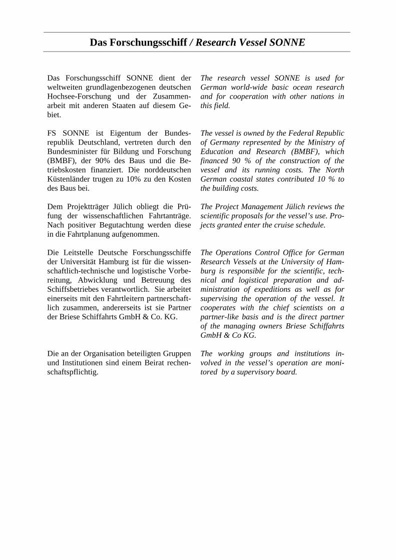
Das Forschungsschiff / Research Vessel SONNE
Das Forschungsschiff SONNE dient der weltweiten grundlagenbezogenen deutschen Hochsee-Forschung und der Zusammen-arbeit mit anderen Staaten auf diesem Ge-biet.
FS SONNE ist Eigentum der Bundes-republik Deutschland, vertreten durch den Bundesminister für Bildung und Forschung (BMBF), der 90% des Baus und die Be-triebskosten finanziert. Die norddeutschen Küstenländer trugen zu 10% zu den Kosten des Baus bei.
Dem Projektträger Jülich obliegt die Prü-fung der wissenschaftlichen Fahrtanträge. Nach positiver Begutachtung werden diese in die Fahrtplanung aufgenommen.
Die Leitstelle Deutsche Forschungsschiffe der Universität Hamburg ist für die wissen-schaftlich-technische und logistische Vorbe-reitung, Abwicklung und Betreuung des Schiffsbetriebes verantwortlich. Sie arbeitet einerseits mit den Fahrtleitern partnerschaft-lich zusammen, andererseits ist sie Partner der Briese Schiffahrts GmbH & Co. KG.
Die an der Organisation beteiligten Gruppen und Institutionen sind einem Beirat rechen-schaftspflichtig.
The research vessel SONNE is used for German world-wide basic ocean research and for cooperation with other nations in this field.
The vessel is owned by the Federal Republic of Germany represented by the Ministry of Education and Research (BMBF), which financed 90 % of the construction of the vessel and its running costs. The North German coastal states contributed 10 % to the building costs.
The Project Management Jülich reviews the scientific proposals for the vessel’s use. Pro-jects granted enter the cruise schedule.
The Operations Control Office for German Research Vessels at the University of Ham-burg is responsible for the scientific, tech-nical and logistical preparation and ad-ministration of expeditions as well as for supervising the operation of the vessel. It cooperates with the chief scientists on a partner-like basis and is the direct partner of the managing owners Briese Schiffahrts GmbH & Co KG.
The working groups and institutions in-volved in the vessel’s operation are moni-tored by a supervisory board.

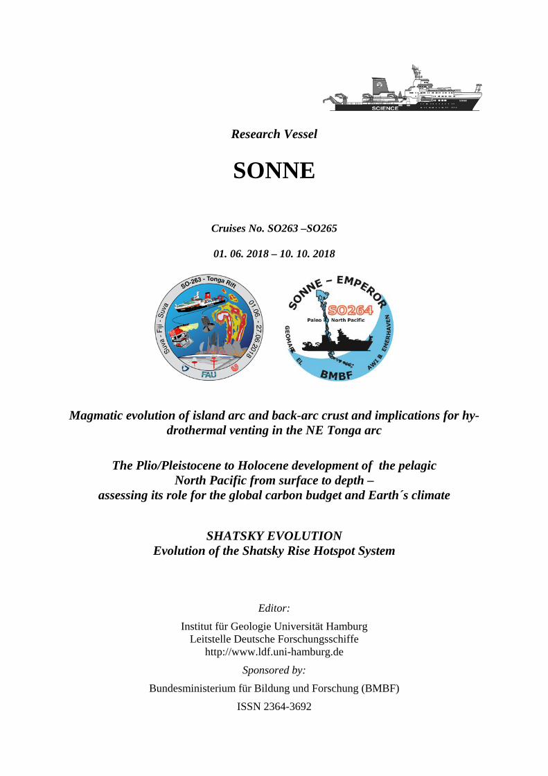
Research Vessel
SONNE
Cruises No. SO263 –SO265
01. 06. 2018 – 10. 10. 2018
Magmatic evolution of island arc and back-arc crust and implications for hy-drothermal venting in the NE Tonga arc
The Plio/Pleistocene to Holocene development of the pelagic North Pacific from surface to depth –
assessing its role for the global carbon budget and Earth´s climate
SHATSKY EVOLUTION Evolution of the Shatsky Rise Hotspot System
Editor: Institut für Geologie Universität Hamburg
Leitstelle Deutsche Forschungsschiffe http://www.ldf.uni-hamburg.de
Sponsored by: Bundesministerium für Bildung und Forschung (BMBF)
ISSN 2364-3692